
|

|

|

ESTIMATION OF NATURAL GROUND WATER RECHARGE
Amitha Kommadath

|
|
|
|
 ABSTRACT
INTRODUCTION
RECHARGE ESTIMATION TECHNIQUES
SOIL WATER BALANCE METHOD
ZERO FLUX PLANE METHOD
ONE DIMENSIONAL SOIL WATER FLOW MODEL
INVERSE MODELLING TECHNIQUE
GROUND WATER LEVEL FLUCTUATION METHOD
HYBRID WATER FLUCTUATION METHOD
GROUND WATER BALANCE METHOD
ISOTOPE AND SOLUTE PROFILE TECHNIQUES
NATURAL GROUND WATER RECHARGE ESTIMATION IN INDIA
CONCLUSION
REFERENCES
ABSTRACT
INTRODUCTION
RECHARGE ESTIMATION TECHNIQUES
SOIL WATER BALANCE METHOD
ZERO FLUX PLANE METHOD
ONE DIMENSIONAL SOIL WATER FLOW MODEL
INVERSE MODELLING TECHNIQUE
GROUND WATER LEVEL FLUCTUATION METHOD
HYBRID WATER FLUCTUATION METHOD
GROUND WATER BALANCE METHOD
ISOTOPE AND SOLUTE PROFILE TECHNIQUES
NATURAL GROUND WATER RECHARGE ESTIMATION IN INDIA
CONCLUSION
REFERENCES
| ABSTRACT: |


|
Water is indispensable to all life on earth. However, fresh water is constantly formed newly through a phenomenon known as hydrological cycle. Ground water recharge is the process by which water percolates down the soil and reaches the water table, either by natural or artificial methods. Here, natural ground water recharge is dealt with. Quantification of the rate of natural ground water recharge is a pre-requisite for efficient ground water resource management. It is particularly important in regions with large demands for ground water supplies, where such resources are the keys to economic development. However, the rate of aquifer recharge is one of the most difficult factors to measure in the evaluation of ground water resources. Estimation of recharge, by any method is normally subject to large uncertainties and errors. In this paper, various methods of estimating natural ground water recharge are outlined and critically reviewed with regard to their limitations and associated uncertainties.
| INTRODUCTION: |
|
Ground water recharge may be explained as the process where by the amount of water present in or flowing through the interstices of the sub-soil increases by natural or artificial means. The amount of water that may be extracted from an aquifer without causing depletion is primarily dependent upon the ground water recharge. Rainfall is the principal source for replenishment of moisture in the soil water system and recharge of ground water. Other sources include recharge from rivers, streams, irrigation water etc. Moisture movement in the unsaturated zone is controlled by suction pressure, moisture content and hydraulic conductivity relationships. The amount of moisture that will eventually reach the water table is defined as natural ground water recharge, which depends on the rate and duration of rainfall, the subsequent conditions at the upper boundary, the antecedent soil moisture conditions, the water table depth and the soil type.
Fresh water is constantly formed anew. This is due to the fact that all the water on earth, either as water vapour in the atmosphere, as subsurface water in streams, lakes, seas and oceans or as ground water in the interstices in the sub-soil, is not at rest, but in a continuous circulatory movement known as the hydrological cycle.
| RECHARGE ESTIMATION TECHNIQUES: |
|
Estimating the rate of aquifer replenishment is probably the most difficult of all measures in the evaluation of ground water resources. The methods available for the estimation of ground water recharge directly from precipitation can be broadly divided into three-inflow, aquifer response and outflow methods according to how the studies are conducted (Kumar C.P, 1977).
The following methods are commonly in use for estimating natural ground water recharge (Sathish Chandra, 1979):
i) Soil water balance method
ii) Zero flux plane method
iii) One-dimensional soil water flow model
iv) Inverse modelling technique
v) Ground water level fluctuation method
vi) Hybrid water fluctuation method
vii) Ground water balance method
viii) Isotope and solute profile techniques
| SOIL WATER BALANCE METHOD: |
|
Water balance models were developed in the 1940s by Thornthwaite (1948) and was later revised. The method is essentially a bookkeeping procedure, which estimates the balance between the inflow and outflow of water. Here, the volume of water required to saturate the soil is expressed as an equivalent depth of water and is called soil water deficit. The soil water balance can be represented by,
Water balance models were developed in the 1940s by Thornthwaite (1948) and was later revised. The method is essentially a bookkeeping procedure, which estimates the balance between the inflow and outflow of water. Here, the volume of water required to saturate the soil is expressed as an equivalent depth of water and is called soil water deficit. The soil water balance can be represented by,
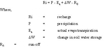
One condition that is enforced, is that if the soil water deficit is greater than a critical value (called the root constant), evapotranspiration will occur at a rate less than the potential rate. The magnitude of the root constant depends on the vegetation, the stage of plant growth and the nature of soil. Various techniques for estimating Ea, usually based on Penman-type equations can be used.
The data requirement of the soil water balance method is large. When applying this method to estimate the recharge for a catchment area, the calculation should be repeated for areas with different precipitation, evapotranspiration, crop type and soil type. This method is of limited practical value, because DW is not directly measurable. Moreover, storage of moisture in the saturated zone and the rates of infiltration along the various possible routes to the aquifer, form important and uncertain factors. Another aspect is that the depth of the root zone may vary in semi-arid regions between 1 and 3 meters. Results from this model are of very limited value without calibration and validation, because of the substantial uncertainty in input data. The model parameters do not have a direct physical representation, which can be measured, in the field.
| ZERO FLUX PLANE METHOD: |
|
The zero flux plane method relies on the location of a plane of zero hydraulic gradient in the soil profile. Recharge over a time interval is obtained by summation of the changes in water contents below the plant. The position of the zero flux plane is usually determined by tensiometers.
Darcy's law gives the flux q, defined as the volume of water per unit time passing through the unit area at any depth:
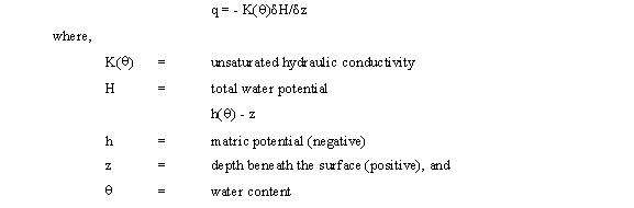
Thus, knowing the unsaturated hydraulic conductivity and potential gradient the flux may be determined. Tensiometers or the neutron scattering technique may be used to measure water potentials. The hydraulic conductivity estimation presents more problems such as (i) K may vary by a factor of 103 or so over the normal moisture content of a typical soil and (ii) K differs depending on the place even in partly homogenous soil
| ONE DIMENSIONAL SOIL WATER FLOW MODEL: |
|
For recharge to occur, water has to move through the unsaturated zone until it reaches the water table. Flow conditions within this zone are far more complex than the flow mechanisms in a saturated aquifer.
The equation of moisture retention curve is a non-linear relation to the water content. Since the moisture retention curve can only be determined experimentally, its true behaviour in practice is only known at a finite number of points. Two methods to obtain values at non-experimental points can be used. The best and most obvious method is by interpolation, but this method can only be successful in those cases where the experimental points are closely spaced. The most recent approach fits an equation to the experimental points. The equations commonly used are the Brooks and Corey function and the Van Genuchten (1980) function. According to Van Genuchten, the moisture retention curve may be expressed as,
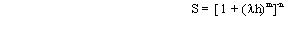
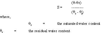
where n and m are characteristic constants which have to be determined for every soil type and m = 1-1/n. This equation expresses the moisture retention curves not in terms of the water content, but rather in terms of the reduced water content defined by the equation
The three parameters namely,
i) the water content
ii) the matric potential (fluid pressure)
iii) the hydraulic conductivity are interrelated
These relationships are however, very sensitive. For example a change in the water content of a few percent often corresponds to a change in the hydraulic conductivity of two or more orders of magnitude.
| INVERSE MODELLING TECHNIQUE: |
|
The inverse modeling technique is a two-dimensional finite element (or finite difference) ground water model of the saturated zone. Current methods of calibrating ground water flow models are either direct or indirect. The indirect approach is essentially a trial and error procedure that seeks to improve an existing estimate approach of the parameters in an iterative manner, until the model response is sufficiently close to that of the real system. The direct approach is different in that it treats the model parameters as dependent variables in a formal inverse boundary value problem.
The inherent non-uniqueness of solution is one of the major difficulty faced in dealing with the inverse problem. Much of the data entered into the inverse modeling technique represent imprecise measurements and processed information that give a distorted picture of the system's true state. The calculation of recharge of an aquifer by the inverse modeling technique must be regarded with caution, if the true 'S' (Storage coefficient) values of the aquifer are not known. If, however, the calibrated S values can be regarded as being very close to the real values, this technique can be of much use in describing the behaviour of the aquifer to the recharge phenomena in general.
| GROUND WATER LEVEL FLUCTUATION METHOD: |
|
This is an indirect method of deducing the recharge from the fluctuation of the water table. The rise in the water table during the rainy season is used to estimate the recharge, provided that there is a distinct rainy season with the remainder of the year being relatively dry. The basic assumption is that the rise in the water table is primarily due to the rainfall recharge. It is recognized that other factors such as pumping or irrigation during the rainy season do not have an influence. If the rise in water table is >Ds, the rainfall recharge, Ri is given by,
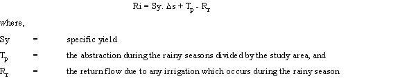
The basic limitation of the above equation is that it neglects the subsurface inflow and outflow and assumes that every inflow and outflow is uniformly distributed over the area. This may be approximately true for the rainfall and even for the return flow from irrigation but it is rarely true for the abstraction from the aquifer. When pumping is reduced or ceases during the rainy seasons, a redistribution of ground water heads occurs so that part of the observed increase in water level may be due to normal well recovery. Moreover, the above equation is dependent on the value of the specific yield, which is difficult to determine since the water table fluctuation occurs in the partially saturated zone.
| HYBRID WATER FLUCTUATION METHOD: |
|
Sophocleous (1991) proposed a hybrid water fluctuation approach to recharge estimation. This method is generally reliable for estimating natural ground water recharge in relatively flat areas with a shallow water table (less than 10m). By associating water table rises with specific precipitation events and by combining the recharge estimates from the soil water balance analysis with the consequent water table rises, one can obtain effective storativity values for each recharge study site, especially after averaging several such values. The site-calibrated effective storativity value can then be used to translate each major water table rise tied to a specific storm period into a corresponding amount of ground water recharge.
Estimation errors in the hybrid water fluctuation method are reduced by running a 'storm period' based soil water balance throughout the year in combination with the associated water level rise. This method gives more reliable results of the recharge estimation than any other approach.
| GROUND WATER BALANCE METHOD: |
|
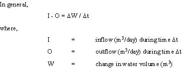
Considering the various inflow and outflow components, the ground water balance equation for a time period ?t is given as:

The above equation is the general ground water balance equation for an unconfined aquifer. The boundaries of an area usually studied do not represent streamlines i.e., they are not perpendicular to the equipotential line. Hence, the lateral inflow and outflow must be accounted for the balance equation.
One of the factors influencing the change in water table is the effective porosity, ne, of the zone in which the water table fluctuations occur. ne changes as the depth of water table changes, especially for water tables less than 3 meters depth. Moreover, it should be noted that if the water drops, part of the water is retained by the soil particles; if it rises, air can be trapped in the interstices that are filling with water. Hence ne for rising water i.e., in general, is less than that for a falling water table. The above equation considers only one aquifer system and does not account for inter flows between the aquifers in a multi aquifer system.
All elements of the water balance equation are computed using independent methods wherever possible. Computations of water balance elements always involve errors, due to shortcomings in the techniques used. The discrepancy of water balance is given as a residual term of the water balance equation and includes the error in the determination of the components, which are not taken into account.
The water balance may be computed for any time interval. To apply the above equation correctly, it is essential that both the area and the period for which the balance is assessed be carefully chosen. All components of the water balance equation other than the rainfall recharge are estimated using the relevant hydrological and meteorological information. The rainfall recharge is calculated by substituting these estimates in the water balance equation. This approach is valid for the areas where the year can be divided into monsoon and non-monsoon periods and the water balance is carried out separately. The former yields an estimate of recharge coefficient and the latter determines the degree of accuracy with which the components of water balance equation have been estimated.
| ISOTOPE AND SOLUTE PROFILE TECHNIQUES: |
|
Isotopes 2H, 3H, 18O and 14C are commonly used in recharge studies, of which the first three most accurately simulate the movement of water, because they form a part of the water molecule. A radioactive tracer provides a means of tracing water movement through the unsaturated zone. In principle, any traces with negligible adsorption may be used, but tritium is preferred. Tritium may either be artificially introduced or environmental tritium may be used. However, environmental tritium has several disadvantages.
i) Tritium is not conservative and is lost from the system by evapotranspiration.
ii) Contamination during sampling and processing is a factor, which is enhanced in remote areas and at low total moisture levels.
iii) Analysis is highly specialized and costly.
iv) Quantitative studies are difficult to achieve, since it is difficult to determine a tritium mass balance.
An environmental tracer suitable for determining the movement of water must be highly soluble, conservative and not substantially taken up by vegetation. The chloride ion satisfies most of these criteria and is therefore considered a suitable tracer, particularly in coastal areas. In this case the ground water recharge is given by,
Ri = D/C (mm/year)
where,
D = wet and dry chloride deposition (mg/m2/year) and
C = concentration in ground water
This method is convenient, fast and cheap. The chief drawback is the uncertainty in the determination of the wet and dry deposition. The principle source of chloride in ground water is from the atmosphere. In this case the recharge can be expressed as
Ri = Rainfall x (Cl of rainfall / Cl of ground water)
The chloride method must be treated with caution. Recharge under conditions of extremely high rainfall with a long recurrence period, is likely to influence the chloride concentration of ground water to a high degree resulting in an over estimate of the mean annual recharge.
| NATURAL GROUND WATER RECHARGE ESTIMATION IN INDIA: |
|
Rainfall is the most important source of ground water recharge in the country. The most commonly used methods for estimation of natural ground water recharge in India include empirical methods, ground water level fluctuation method and the ground water balance method.
Based on the studies undertaken by different scientists and organizations regarding correlation of ground water level fluctuation and rainfall, some empirical relationships have been developed for computation of natural recharge to ground water from rainfall. Some of these empirical relationships for different hydrogeological situations in India are:
a) Chaturvedi Formula
Based on the water level fluctuation and rainfall amounts in Ganga-Yamuna doab, Chaturvedi (1973) derived an empirical relationship to arrive at the recharge as a function of annual precipitation (when rainfall exceeds 40cms).
R = 2.0 (P - 15)0.4
where,
R = net recharge due to precipitation during the year, in inches
P = annual precipitation, in inches
This formula was later modified by further work at the UP Irrigation Research Institute, Roorkee, and the modified form of the formula is,
R = 1.35 (P-14)0.5
The Chaturvedi formula has been widely used for preliminary estimation of ground water recharge due to rainfall. It may be noted that there is a lower limit of the rainfall below which the recharge due to rainfall is zero. The percentage of rainfall recharged commenced from zero at P = 14 inches, increases upto 18% at P = 28 inches, and again decreases. The lower limit of rainfall in the formula may account for the soil moisture deficit, interception losses and potential evaporation. These factors being site specific, one generalised formula may not be applicable to all the alluvial areas.
b) Amritsar formula
Using regression analysis for certain doabs in Punjab, Sehgal developed a formula in 1973, for Irrigation and Power Research Institute, Punjab. The formula was found to hold good for areas were rainfall was between 60 and 70 cms.
R = 2.5 (P - 0.6)0.5
where,
R & P both are measured in inches
c) Relationship of Krishna Rao
Krishna Rao gave the following empirical relationship in 1970 to determine the ground water recharge in limited climatological homogenous areas.
R = K (P - X)
The following relation is stated to hold good for different parts of Karnataka;
R = 0.20 (P - 400) for areas with P between 400 and 600mm
R = 0.25 (P - 400) for areas with P between 600 and 1000mm
R = 0.35 (P - 600) for areas with P above 2000mm
where,
R & P are expressed in millimeters
| CONCLUSION: |
|
| REFERENCES: |
|
| ADDRESS: |
|
1.) Student: I M.E. Environmental Engineering,
Government College. of Technology,
Coimbatore - 641 013
|
|
|