http://www.iisc.ernet.in/
Ecosystem Goods and Services in Uttara Kannada
http://wgbis.ces.iisc.ernet.in/energy/
Energy and Wetlands Research Group, Centre for Ecological Sciences [CES], Indian Institute of Science, Bangalore – 560012, India.
*Corresponding author:
cestvr@ces.iisc.ernet.in

Study Area

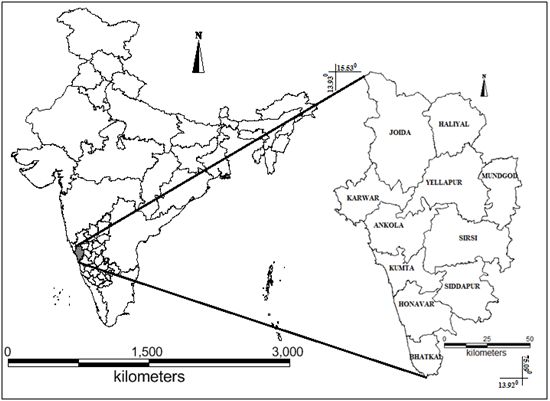
Uttara Kannada district is located in the north – western part of Karnataka state, in India. It lies between 13.9220o N to 15.5252o N latitude and 74.0852o E to 75.0999o E longitude. The district cover an area of 10, 291 km2 which is sub-divided into 11 taluks. The district has the population of 13.53 lakh persons. The population density of the district is 132 persons per km2, which is the lowest in the state. Figure 2 depicts the population density across taluks, the highest population density in Bhatkaltaluk (420 persons per km2) and the least in Supataluk (26 persons per km2). The district’s diverse economy span across subsistence farming, modern agricultural practice, horticulture, forestry, fisheries, handicrafts, industries, power generation, mining, seaports, tourism and many other services. The district ranks at seventh place in the state of Karnataka in terms of Human Development with HDI value of 0.65 and the district is one among the five districts with highest education index value (KHDR, 2005).


Figure 1: Geographical Location of Uttara Kannada District


Figure 2: Talukwise Population Density in Uttara Kannada

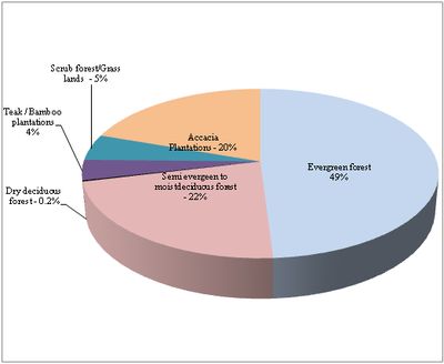
Figure 3 depicts the land use in the district based on the analysis of IRS P6 (Indian remote sensing) multi spectral data of spatial resolution 5.8 m.  Area under forests covers 71.72% of the total geographic area of the district. The forest cover ranges from 47% (Mundgod) to 85% (Supa and Yellapur taluks). Figure 4 illustrates that about 49% of the total forest land in the district is of evergreen type followed by 22% of semi-evergreen to moist deciduous forests. Dry deciduous forests are very less and are found in the eastern part of Haliyal and Mundgod taluk. There has been a significant amount of forest loss owing to various developmental activities across district and conversion of natural forests into plantations. Forest resources across taluks generate significant use and non – use values at local and regional levels. Income obtained from forest substantially supports the majority of the rural communities who are either agriculture or landless poor. A large portion of the income of the tribal and pastoral communities in the district is derived from gathering economy which they use for subsistence as well for marketing.


Figure 3: Land –use Map of Uttara Kannada District


Figure 4: Vegetation Distribution in Uttara Kannada

BACK  «  TOP  »  NEXT
Citation : Ashwath D.N., Subash Chandran M.D. and Ramachandra. T.V, 2012. Ecosystem Goods and Services in Uttara Kannada., Proceedings of the LAKE 2012: National Conference on Conservation and Management of Wetland Ecosystems, 06th - 09th November 2012, School of Environmental Sciences, Mahatma Gandhi University, Kottayam, Kerala, pp. 1-9.
* Corresponding Author :
Dr. T.V. Ramachandra
Energy & Wetlands Research Group, Centre for Ecological Sciences, Indian Institute of Science, Bangalore – 560 012, India.
Tel : +91-80-2293 3099/2293 3503 [extn - 107],      Fax : 91-80-23601428 / 23600085 / 23600683 [CES-TVR]
E-mail : cestvr@ces.iisc.ernet.in, energy@ces.iisc.ernet.in,     Web : http://wgbis.ces.iisc.ernet.in/energy, http://ces.iisc.ernet.in/grass
E-mail    |    Sahyadri    |    ENVIS    |    GRASS    |    Energy    |      CES      |      CST      |    CiSTUP    |      IISc      |    E-mail