MATERIAL AND METHODS |
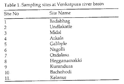
In order to assess the spatial variation of water quality in the river basin, 11 sampling stations were identified (Table 1, Figure 1) and sampling was carried out during post monsoon. Physico-chemical variables were analysed according to APHA, 1985 and Trivedy and Goel, 1986. Streams network in the catchment was digitized based on Survey of India toposheets (1:50, 000) using GIS software. Based on this layer, hydrological parameters like drainage density, catchment area, stream density and stream length were computed. Land use analysis was done with the LISS Data of IRS 1C remote sensing data (of 04 January 2004) using supervised classification based on the maximum likelihood classifier (MLC) with ILWIS 3.1 Image processing software.