 |
IMPACT OF HYDROELECTRIC PROJECTS ON COMMERCIAL
BIVALVES IN A SOUTH INDIAN WEST COAST ESTUARY
|
 |
M. Boominathanta,b, G. Ravikumarb, M. D. Subash Chandrana, T.V. Ramachandraa,*
aEnergy and Wetlands Research Group, Centre for Ecological Sciences,Indian Institute of Science, Bangalore – 560 012, Karnataka, India
bDepartment of Zoology and Biotechnology, A.V.V.M.Sri Pushpam College,Poondi – 613 503,TamilNadu, India
*Corresponding author:cestvr@ces.iisc.ac.in, energy@ces.iisc.ac.in.
Materials and Method
Study area
Both the estuaries studied for bivalves, namely Kali and Aghanashini, are situated towards the central west coast of India, in the Uttara Kannada district of Karnataka (Fig. 1 for locations). The Kali estuary is the northernmost estuary of the district and the Aghanashini estuary is located about 42 km south of it. The Kali River originates near the village Diggi in the densely wooded and hilly Joida taluk of the district. Joined by several streams en route its 184 km course towards the Arabian Sea, is through the rugged terrain of the Western Ghats. Its confluence with the sea is about three km north of Karwar town. Between 1980 and 2000 a series of hydroelectric projects was executed upstream in the river, involving dam constructions at Supa, Bommanhalli, Nagjhari, Kodashalli and Kadra. The estuarine portion of Kali, during the pre-dam period, extended for about 18 km interior from Kodibag at the river mouth to Kerwadi and covered an area of about 30 km2 (Nair et al. 1984).
Preferable place to insert
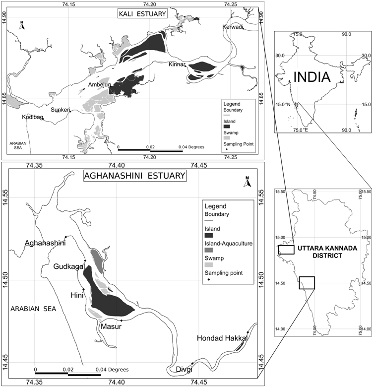 Figure 1 Sampling sites in Kali and Aghanashini estuaries of Uttara Kannada District
The Aghanashini River, originating from two sources, at Manjguni and Donihalla, both in the Sirsi Taluk of Uttara Kannada, runs its 121 km course winding through deep gorges and valleys towards the Arabian Sea, also through richly wooded landscape of the Western Ghats. The river joins the sea between the villages Tadri in the north and Aghanashini in the south about 10 km towards the north of Kumta town. The high tides from the Arabian Sea reach up to Uppinapattana at about 25 km upstream in the river, conferring estuarine status to about 21 km2 of water spread area. As Aghanashini has no hydel projects the estuary is expected to retain its original salinity regimes. The study of Aghanashini bivalves is expected to portray a situation unaffected by hydel projects, which could have been similar to that of its counterpart Kali of pre-dam period. The study area map (Fig. 1), covering both the estuaries, was created by using QGIS version 1.7.4 (Quantum GIS Development Team 2011).
Salinity measurements
In both the estuaries, surface water salinity was measured in February 2012 during high tide using EXTECH EC400 salinity meter. After the subsidence of the torrential monsoon rains, normally in October, salinity starts rising in the estuary, and attain peak salinity conditions by February. Salinity levels that prevailed in the Kali estuary in the pre-hydel power project period were obtained from Nair et al. (1984). Bar graph to showing the salinity difference was produced using statistical software R version 3.0.1 (R Core Team 2013).
Bivalve data collection
The presence of different commercial bivalves in both the estuaries was obtained from Alagarswami and Narasimham (1973) and Rao et al. (1989). Nair et al. (1984) had provided data on distribution range of bivalves in the pre-dam Kali estuary. A later study by Rao et al. (1989) on bivalve diversity in Kali is also quite informative. Live and dead bivalves, the latter represented by shells, were collected randomly from different parts of both the Aghanashini and Kali estuaries, and from persons involved in bivalve fishery. A questionnaire was also used to gather information from the fisher-folks of Kali estuarine villages on bivalve diversity and distribution in the pre-dam period and current times. About 50 members of the fisher-folks were interviewed for this purpose. The data gathered is covered the occurrences of commercial bivalves Tegillarca granosa, Meretrix casta, M. meretrix,Paphiamalabarica, Polymesodaerosa Solander, Villoritacyprinoides and estuarine oysters. As sand mining from both the estuaries was taking place at different localities, searches were also made in the excavated sands for bivalve occurrences. The bivalves collected were identified using diagnostic characters given by Apte (1998), Dey (2006), Morton (1984), Rao (1989), and Rao et al. (1989).
Citation :M. Boominathan, G. Ravikumar, M.D. Subash Chandran and T.V. Ramachandra, 2014. Impact of Hydroelectric Projects on Commercial Bivalves in a South Indian West Coast Estuary, J Biodiversity, 5(1,2): 1-9
|
|
|