Introduction
The forests are valuable resources on innumerable counts viz. as sources of various useful products to humans, for their environmental and ecosystem services (soil and water conservation, regulation of water flow, carbon sequestration, nutrient cylcing etc.) and as centres of biodiversity (Ramachandra, 2007). A wide range of benefits to mankind particularly comes from the tropical forests. Estimating the ‘total economic value’ of forests has become a popular topic and research discussion in the conservation community (Lele et al., 2000). Out of the total 329 million ha land area of India, 43% was under cropping and 23% classified as forests (Ministry of Environment and Forests, 1999). The total area of forest cover in India, as per the latest assessment by Forest Survey of India (2011), has been put at 692,027 km2, or merely 21.05% of the total geographical area. Indian forests were classified by Champion and Seth (1968) into four major groups, namely, tropical, sub-tropical, temperate, and alpine. These were further divided into 16 type groups: Tropical (wet evergreen, semi-evergreen, moist deciduous, littoral and swamp, dry deciduous, thorn, dry evergreen), Sub-tropical (broad leaved hill forests, pine, and dry evergreen), Temperate (montane wet, Himalayan moist temperate, Himalayan dry temperate), and Alpine (sub-alpine, moist alpine and dry alpine scrub). Of these 16 types, tropical dry deciduous constitute the major percentage of the forest cover in India.
The Western Ghats range of hills, running close and parallel to the Arabian Sea along the western Peninsular India for about 1600 km from the south of Gujarat to Kanyakumari, covers an area of about 1,60,000 sq.km. (Ramachandra, 2007). It is among the 34 global biodiversity hotspots on account of exceptional plant endemism and serious levels of habitat degradation. The complex geography, wide variations in annual rainfall from 1000-6000 mm, and altitudinal decrease in temperature, coupled with anthropogenic factors, have produced a variety of vegetation types in the Western Ghats. While tropical evergreen forest is the natural climax vegetation of the more humid western slopes, along the rain-shadow region eastwards vegetation changes rapidly from semi-evergreen to moist and dry deciduous forests, the last one being characteristic of the semi-arid Deccan region as well. Lower temperature, especially in altitudes exceeding 1500 m, has produced a unique mosaic of montane ‘shola’ evergreen forests alternating with rolling grasslands, mainly in the Nilgiris and the AnamalaisAll these types of natural vegetation are prone to or have already undergone degradations due to human impacts (Pascal, 1986; 1988).
The Western Ghats harbours very rich flora and fauna and there are records of over 4,000 species of flowering plants (38% endemics), 330 butterflies (11% endemics), 156 reptiles (62% endemics), 508 birds (4% endemics), 120 mammals (12% endemics), 135 amphibians (75% endemics) and 289 fishes (41% endemics) (Daniels, 2003; Gururaja, 2004; Sreekantha et al., 2007; Ramachandra et al., 2007).
The major forests and associated vegetation types of the Western Ghats are the following:
- Tropical wet evergreen forests – natural climax of high rainfall areas (>200 cm/year)
- Semi evergreen forests – natural climax of moderate rainfall areas (150-200 cm/year) and caused also by disturbances to evergreens
- Moist deciduous forests – natural to 100-150 cm rainfall areas and anthropogenic factors, especially fire in higher rainfall zones
- Dry deciduous forests – in areas with less than 100 cm/year rainfall
- Shola forests – stunted evergreens in the wind protected high altitutde valleys (>1500 m)
- Shola grasslands and grassy blanks – former in high altitude exposed slopes and tops and latter anywhere else due to human impacts
- Savannas – manmade alterations in natural forests; composed grasslands with distantly placed trees
- Scrubs and thickets in highly disturbed areas.
PROFILE OF UTTARA KANNADA FORESTS
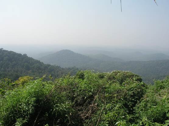
Figure 1 Evergeen to semi-evergreen forest clad hills in Honavar taluk
The Uttara Kannada the northernmost coastal district of Karnataka State (13.9220o N to 15.5252o N lat. and 74.0852o E to 75.0999o E long.) has a geographical area of 10, 291 km2. Topographically the district can be divided into three zones – the narrow and relatively flat to low hilly coastal along the west of Karwar, Ankola, Kumta, Honavar and Bhatkal taluks; the precipitously rising main range of Western Ghats towards the eastern interior of these taluks, the crestline zone composed of Sirsi, Siddpur Supa and Yellapur taluks and Haliyal and Mudgod taluks towards the north-east flattening and merging with the Deccan Plateau. Forest Survey of India (2011) reveals 76% of the district’s area as covered by forests. Akbar Shah (1988) treated 1388.89 km2 of the district’s forests as partially open, 1646.16 km2 as of medium density and only 714.55 km2 as closed forest. Daniels et al. (1989; 1993) divided Uttara Kannada vegetation into 5 broad zones namely – Coastal, Northern evergreen, Southern evergreen, Moist deciduous and Dry deciduous zones. The evergreen to semi-evergreen forests (Figure 1) form major portion of the district especially towards the west which experiences heavy rainfall. With the decline of rainfall towards the eastern portion, the forests change rapidly from moist deciduous to dry deciduous types. Most of the forests towards the western are considered to be of secondary nature owing mainly to the slash and burn cultivation practices which were widely prevalent up to the mid of 19th century and thereafter in an attenuate form until the close of the century. These forests today are in different stages of secondary succession, and in many places old growth forests would appear like the primary forest itself (Chandran 1997, 1998; Chokkalingam et al., 2000).
The earlier accounts of vegetation studies from this district include details of botanical excursions by Santapau (1955) followed by Puri (1960) who gave a general account of the forests of this district. Champion and Seth (1968) classified the vegetation of western and crestal Uttara Kannada as west coast evergreen/ semi-evergreen forest while Pascal (1982, 1984; Pascal et al 1982) in his vegetation maps (on 1: 250000 scale) classified theforests in the high to moderate rainfall areas of Uttara Kannada as mainly Persea macrantha-Diospyros spp.-Holigarna spp. type along with fragments of Dipterocarpus indicus-Diospyros candolleana-Diospyros oocarpa types towards the southern portions, mainly in the Siddapur hills. Chandran (1995) pointed out that before the entry of agricultural and pastoral people, over three millennia ago, primary forests would have covered the district, and quotes palynological evidences based on Caratini et al (1991), which highlighted the decline in forest pollens and increase in savannah pollens from marine core studies from karwar coast towards middle of fourth millennim BP. The forest clearances could have been for shifting cultivation and human settlements. Daniels et al (1995) attributes the reasons for the disappearance of several evergreen species to their inability to coppicing following industrial usages and several other human disturbances. There is a need to monitor the history of fire episodes for different forest types in order to interpret the changes in the semi-evergreen forests. Most of the remnants of good forests could have been converted to secondary forests due to large scale human activities. Based on regeneration patterns of forests in Uttara Kannada and afforestation of almost 6500 ha of land in the post1980’s, Bhat et al. (2000; 2001) gave good prospects for secondary forests. Based on land cover and land use analysis of remote sensing data Ramachandra (2007) observed that high anthropogenic pressures in the district are causing slow transformation of evergreen forests to semi-evergreen and other human impacted landscape elements.
Uttara Kannada possessed many forests traditionally designated by locals as ‘kans’ which were relatively less impacted areas of climax evergreen forests, being sacred groves protected by the people through generations. Kans were referred to first, in the travel account of Francis Buchanan, a British officer designated by Lord Wellington to study the newly conquered British territories along south-west India (Buchanan, 1870; Chandran & Gadgil, 1998). Buchanan found these kans as lofty evergreen forests preserved for growing pepper amidst relative barrenness of the coastal hills. Near Karwar the locals claimed the sacredness of forests to them (referring obviously to the kans) and the need for permission from the village headman, also the priest to village deities, for any inevitable tree cutting which was otherwise considered a taboo. Wingate (1888), the then forest settlement officer of the district noted that the kans were of “great economic and climatic importance and favored the existence of springs, perennial streams and generally indicated the proximity of valuable spice gardens, which derive from them both shade and moisture.”
The kans were large sacred groves, each covering few to few hundred hectares in their original state. There were many such sacred kans in the rest of the evergreen forest belt of the district as well as in other Malnadu districts of Karnataka (Chandran & Gadgil, 1993; 1998). About 4,000 ha of kans from Sirsi and Siddapur taluks were included in a forest working plan for extraction of industrial timbers (Shanmukhappa, 1966). Siddapur taluk of Uttara Kannada, in the Bombay Presidency under the British regime, had 113 kans according to Village Forest Registers (Gokhale, 2001). Some Kans of southern Uttara Kannada, harbour fragments of Myristica swamps, an endangered and ancient habitat of high watershed value (Chandran and Mesta 2001). Gadgil and Chandran (1989) noted that Dipterocarpus indicus of Western Ghats had its northern limits in Uttara Kannada with some of the kans being the only refuge for it. Chandran et al. (2010) studied the detailed ecology including species diversity, basal area, biomass and carbon sequestration of the swampy relic forests of Kathalekan in Uttara Kannada. The study revealed that this forest harbored relic trees such as Dipterocarpus indicus (Endangered) and Palaquium ellipticum and has a network of perennial streams and swamps sheltering endemic and rare population in the world of the tree Semecarpus kathalekanensis (new discovery by Dasappa and Swaminath, 2000) Syzygium travancoricum (Critically Endangered), Myristica magnifica (Endangered), Gymnacranthera canarica (Vulnerable).
The notable tree species found in the different forests are:
- Evergreen forests: Dipterocarpus indicus (in few locations only), Ficus nervosa, Palaquium ellipticum, Syzygium gardenerii, Holigarna grahamii, Artocarpus hirsutum, Dysoxylum malabaricum, Lophopetalum wightianum, Diospyros sylvatica etcare found as emergent species. In the second strata that make an unbroken canopy are medium height trees like Actinodaphne agustifolia, Cinnamomum spp., Diospyros candolleana, Hopea ponga, Myristica spp., Garcinia spp., Knema attenuata, etc. In the lowermost woody strata occur smaller trees and shrubs such as Aglaia anamallayana, Diospyros saldhnae, Syzygium laetum, and some palms like Arenga wightii and Pinanga dicksonii. Lianas are many as well as canes. Most ancient patches of climax forests alone have Myristica swamps and Dipterocarpus indicus.
- Semi evergreen forests: Forests in heavy to moderate rainfall areas subjected to human pressures currently, or in the past due to shifting cultivation etc. tend to be semi-evergreen in nature. These share most evergreen tree species with the evergreen climax forests, but are distinguished by the presence of certain deciduous trees such as Lagerstroemia microcarpa, Terminalia spp. Schleischera oleosa, Stereospermum personatum, Tetrameles nudiflora, Vitex altissima etc. In addition some evergreen species like Alstonia scholaris, Holigarna arnottiana, Mammea suriga, Carallia integerrima etc. are more characteristicof the latter. Climbers and lianas and canes are abundant.
- Moist deciduous forests: Natural moist deciduous forests occur along the rainshadow region where annual rainfall is less than 1500 mm., especially in the taluks of Yellapur east, Haliyal and western parts of Mundgod. Secondary moist deciduous forests could occur anywhere as regeneration in fire affected areas (Mesta, 2008). The species that frequently occur here are Adina cordifolia, Aporosa lindleyana, Careya arborea, Dillenia pentagyna, Lagerstroemia microcarpa, Spondias spp, Strychnos nuxvomica, Terminalia paniculata, T. tomentosa, Xylia xylocarpa etc. Teak, Tectona grandis, occurs naturally along with bamboos, especially Bambusa arundinacea and Dendrocalamus strictus. Teak plantations are plentiful in this zone. Climbers and lianas are present in these forests but lesser in diversity compared to the evergreen-semievergreen forests.
- Dry deciduous forests: In plains and undulating terrain in Mundgod and eastern Haliyal, where rainfall drastically reduces to less than 1000 mm, these forests constitute the natural climax. Trees mainly found here are Albizzia spp., Anogeissus spp., Careya arborea, Bauhinia racemosa, Bombax ceiba, Bridelia retusa, Dalbergia latifolia, Diospyros melanoxylon, D. montana, Lagerstroemia parviflora, Tectona grandis, Terminalia paniculata, Terminalia tomentosa, etc. Teak trees here do not attain large girths and these forests were formerly also known as ‘teak pole’ forests.
- Scrub-savannas: These are formations owing their origin to severe human impacts of past and present. They occur anywhere in the district. The scrub is characterized by shrubby plants, often thorny and spinous ones, with stunted trees. The latter include Careya arborea, Odina wodier, Phyllanthus emblica, Sapium insigne, Sterculia urens, Strychnos nux-vomica, Terminalia chebula, Zanthoxylum rhetsa etc. Of the shrubby plants are Embelia tsjeriam-cottam, Grewia microcos, Helectris isora, Ixora coccinia, Leea macrophylla, Tephrosia purpurea etc. The thorny/spinous shrubs and climbers include Capparis spinosa, Zizyphus rugosa, Plectronia parviflora etc.
- Forest plantations: Over a period of more than a century monoculture forest plantations have been raised in the district. The earliest plantations were of teak and Casuarina, the latter along the sandy coastal stretches, especially in Karwar and Kasarkod (in Honavar taluk). Teak plantations became widespread throughout the district in an effort to meet the rising timber needs and for raising revenues. In the 1960’s began plantations of eucalypts and Acacia auriculiformis a couple of decades later. Mixed plantations of utility trees are being raised in the degraded forests in the vicinity of villages through the involvement of village forest committees.
Citation : Ramachandra T.V., Subash Chandran M.D., Rao G R, Vishnu D. Mukri and Joshi N.V., 2015. Floristic diversity in Uttara Kannada district, Karnataka, Chapter 1, In Biodiversity in India-Vol. 8, Pullaiah and Sandhya Rani (Eds), Regency publications, New Delhi, Pp 1-87
Corresponding author:
|
| |
Dr. T.V. Ramachandra
Energy & Wetlands Research Group, CES TE 15
Centre for Ecological Sciences
New Bioscience Building, Third Floor, E –Wing
[Near D-Gate], Indian Institute of Science,
Bangalore – 560 012, INDIA.
Tel : +91-80-2293 3099/2293 3503 - extn 107
Fax : 91-80-23601428 / 23600085 / 23600683 [CES-TVR]
E-mail : cestvr@ces.iisc.ac.in, energy@ces.iisc.ac.in,
Web : http://wgbis.ces.iisc.ac.in/energy |
|