T. V. Ramachandra (*,+), Uttam Kumar (*), S.N. Prasad (#) & Vaishnav B(*)
* Centre for Ecological Sciences, Indian Institute of Science
+ Centre for Sustainable Technologies, Indian Institute of Science
# Salim Ali Centre for Ornithology and Natural History, Dehradun
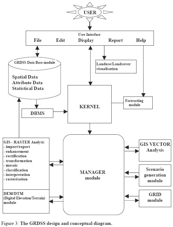
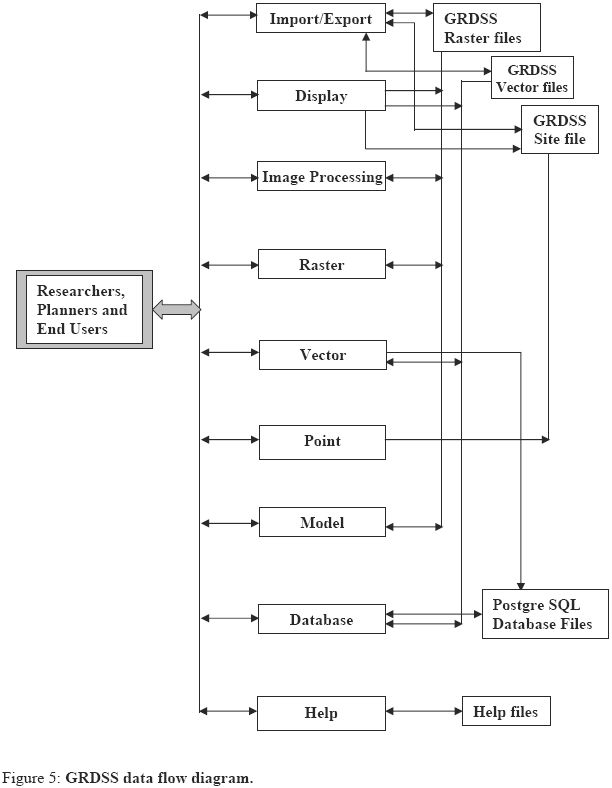
 Figure 1: GRDSS
The process of developing the GUI also involved undertaking the task of identifying the
commands and implementation of the interfacing code. The layout of the interface had to
be altered to suit the end user's perspective. Figure 2 shows the structural diagram of the
GRDSS graphical user interface.
Abstract
Fully structured and matured open source spatial and temporal analysis technology seems
to be the official carrier of the future for planning of the natural resources especially in
the developing nations. This technology has gained enormous momentum because of
technical superiority, affordability and ability to join expertise from all sections of the
society. Sustainable development of a region depends on the integrated planning
approaches adopted in decision making which requires timely and accurate spatial data.
With the increased developmental programmes, the need for appropriate decision support
system has increased in order to analyse and visualise the decisions associated with
spatial and temporal aspects of natural resources. In this regard Geographic Information
System (GIS) along with remote sensing data support the applications that involve spatial
and temporal analysis on digital thematic maps and the remotely sensed images. Open
source GIS would help in wide scale applications involving decisions at various
hierarchical levels (for example from village panchayat to planning commission) on
economic viability, social acceptance apart from technical feasibility. GRASS
(Geographic Resources Analysis Support System, http://wgbis.ces.iisc.ernet.in/grass) is
an open source GIS that works on Linux platform (freeware), but most of the applications
are in command line argument, necessitating a user friendly and cost effective graphical
user interface (GUI).
Keeping these aspects in mind, Geographic Resources Decision Support System
(GRDSS) has been developed with functionality such as raster, topological vector, image
processing, statistical analysis, geographical analysis, graphics production, etc. This
operates through a GUI developed in Tcltk (Tool command language / Tool kit) under
Linux as well as with a shell in X-Windows. GRDSS include options such as Import
/Export of different data formats, Display, Digital Image processing, Map editing, Raster
Analysis, Vector Analysis, Point Analysis, Spatial Query, which are required for regional
planning such as watershed Analysis, Landscape Analysis etc. This is customised to
Indian context with an option to extract individual band from the IRS (Indian Remote
Sensing Satellites) data, which is in BIL (Band Interleaved by Lines) format. The
integration of PostgreSQL (a freeware) in GRDSS aids as an efficient database
management system.
Introduction
GIS (Geographic Information System) is a system of hardware, software and procedures
to facilitate the management, manipulation and analyses of spatial-temporal data. Its
application is wide ranging from micro level to macro level planning. However this
boundless capabilities are limited by ones ability to visualise its implications. It has
become an important component in regional planning with a pivotal role in major
decisions related to earth resources. This includes urban sprawl analysis involving growth
and migration of population, location of industries, employment activities, basic infrastructure (water, electricity, etc.), transportation (railway and road networks),
drainage system (river basin quality, etc.), town planning, etc.
With the growing incidence of ecological and environmental impacts, GIS has been used
to analyse the impact of human activities on the ecosystems. This is possible due to the
options to display and analyse changes in the geo-referenced temporal and spatial data.
This helps to solve complex problems regarding planning and management of resources
and also biophysical modeling. The data input includes spatial, statistical and thematic
data derived from a combination of existing maps, aerial photographs, interpretation of
remotely sensed images and secondary data from the government agencies (census data,
land use data, etc.). Digital image processing technique aids in restoration and
rectification of data, segmentation of data and also in visualisation. The integration of
spatial and temporal technology help in addressing challenges faced by the environment.
The integration of GIS with remote sensing data offers enhanced capability for
inventorying, mapping, monitoring and modeling to understand many environmental
processes. This integration also helps in using remotely sensed image to update the GIS
and also maps. The GIS thematic data and attributes are used to guide image
classification. GRASS, a GIS based open source software distributed under the GNU
GPL (General Public License) integrates these two technologies resulting in numerous
advantages.
GRASS was originally developed by the U.S. Army Construction Engineering Research
Laboratories, a branch of the US Army Corp of Engineers, as a tool for land management
and environmental planning by the military. GRASS is a raster/vector GIS, image
processing system, and graphics production system (http://wgbis.ces.iisc.ernet.in/grass).
GRASS contains over 350 programs and tools to render maps and images on monitor and
paper; manipulate raster, vector, and sites data; process multi spectral image data; and
create, manage, and store spatial data. GRASS has the options to interface with printers,
plotters, digitizers, and databases to develop new data as well as manage existing data.
GRASS uses both intuitive windows interface as well as command line syntax for ease of
operations and is supported by developers and users worldwide. Numerous sub modules
existed in GRASS but most of them are in command line arguments. The command line
syntax for GRASS was cumbersome and time consuming for individuals, who were not
exposed to computer programming and did not possess any programming skills. In order
to overcome this difficulty, it was the necessity for an economically viable, technically
superior and a more flexible spatial and temporal analyses tools that led to the
development of a user friendly graphical user interface (GRDSS) for GRASS GIS along
with the database component as depicted in figure 1.
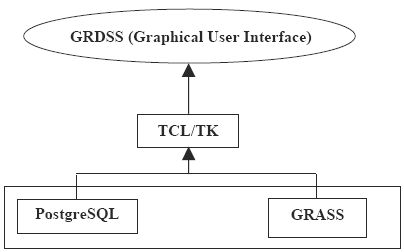 Figure 2: GRDSS - GUI structural diagram
The current development in GRDSS in the allied technologies of remote sensing and GIS
is to build an integrated spatial decision support system (SDSS). Recent advances in the
development of graphical user interface based programming have enabled rapid
prototyping, testing, and application development. Various GIS packages such as
MapInfo (http://mapinfo.com), Idrisi (http://www.idrisi.clarku.edu), Geomedia (http:// w
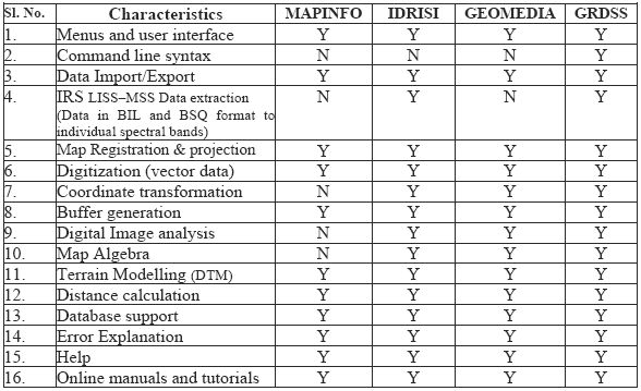
ww.intergraph.com) etc were comparatively studied as per the set criteria listed in table 1.
The limitations of the commercial GIS softwares were also considered while
implementing the GRDSS to offer optimal performance. The following feature
characterises GRDSS development.
- System requirements - The GRDSS GUI sources can be compiled on all PC's
running LINUX. It is a full system with X Window graphical user interface.
Minimum PC can be 486 (or better), with "LINUX". The Linux- system with a
three-button mouse, 32 MB RAM (64 MB recommended) and a hard disk space
of 250MB (beside DOS/Windows partition). GRDSS binaries require only 45-50
MB and to compile additional 150 MB disk space is required (to store the
sources). The GRDSS source code can be compiled using a GNU "C" compiler.
- User friendly interface and menu organisation - The user interface is designed to
suit to the users in India and those who are not much exposed to programming.
The interface is customized and simplified comparable to proprietary softwares in
the market. The menu is organised sequentially in a user-friendly environment
that satisfies both specific and common users.
- Functional capabilities - GRDSS is equipped with the functional capabilities such
as data import/export in different formats (including the IRS data format), map
analysis, data modeling, buffer generation, spatial and non spatial statistical
calculation, digital image processing (spatial, spectral and temporal data analysis),
raster, vector and point analysis and query, map calculator, terrain modeling,
erosion modeling, report generation and can also handle spatial and non-spatial
database (both spatial data and attribute information), etc.
- Help facilities – GRDSS extends all the help facilities present in GRASS. All the
commands with their functions and options are present in help to get started with
the GRDSS. There is a mailing list and mailing list archive where users can post
their doubts and can discuss through e-mails worldwide. The help facilities andthe documents available on the GRASS official website provide enough
information to start with the software.
- Error explanation and manual support - GRDSS is equipped with error
explanation, which automatically renders error messages through the mail facility
in Linux. Beside many sample data sets are available on the GRASS official
website, including online tutorials and manuals.
Overview and description of GRDSS | |
GRDSS supports all basic features required by any GIS package.
- It supports a wide range of data Import/Export that are also supported by other
standard GIS including IRS (LISS3 and PAN) data extraction and DTEM/DTED
(Digital Terrain Elevation Model / Digital Terrain Elevation Data) extraction.
- It has capabilities for displaying the raster/vector images. GRDSS can further
interact with commercial plotters and printers and is capable of color
management.
- GRDSS has the image processing capabilities (rectification, enhancement,
transformation, classification, data analysis, etc.).
- GRDSS has the capability of manipulating raster, vector and point data. This
includes digitization, topology creation, map overlay, arithmetic operations, DEM
generation, decision support, distance, area and statistical report, etc.
- It can perform wetland analysis, terrain modeling with slope, aspect, relief,
profile, cost between two locations to analyze terrain data, runoff-modeling, etc.
- Thematic data preparation, histogram generation, and charts of different formats.
- Database (PostgreSQL) management system.
- Online tutorials with help manuals and sample datasets. Figure 4 depicts the
GRDSS hierarchical menu arrangement.
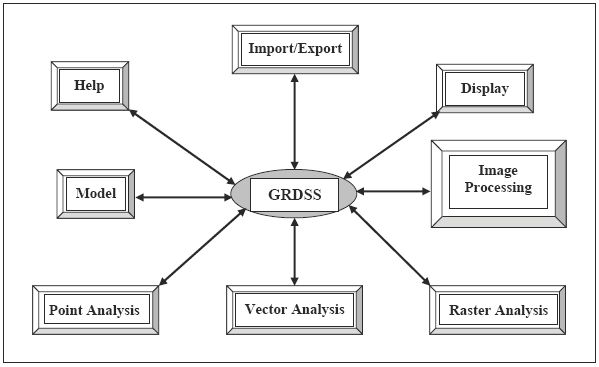
Figure 4: GRDSS hierarchical menu arrangement.Table 2: Functions of GRDSS modules
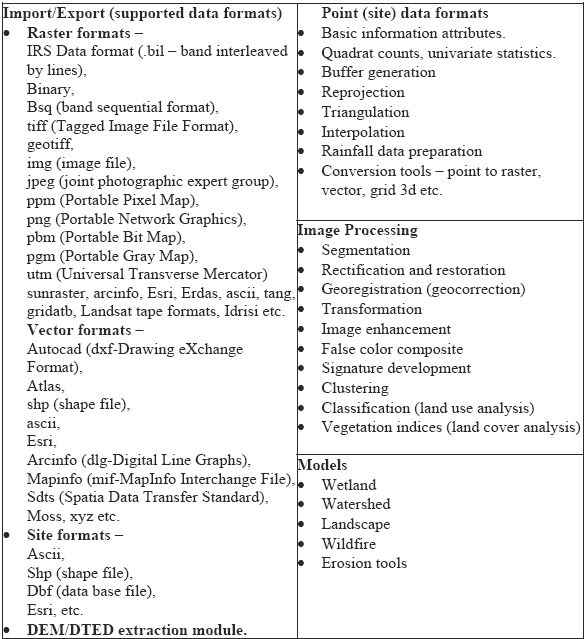
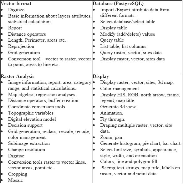
Table 2: Functions of GRDSS modules
GRDSS uses PostgreSQL (a freeware) as a database for data storage, data retrieval, query and manipulation of both spatial and attribute information. It is the most advanced open
source database server used primarily for data storage and retrieval, and complex data
analysis. PostgreSQL is a sophisticated object-relational database management system
(ORDBMS). An ORDBMS is an extension of the more traditional relational database
management systems (RDBMS). For the advanced developer, PostgreSQL even supports
extensibility of its data types and procedural languages.
PostgreSQL has comprehensive SQL support, referential integrity, MVCC or Multi-
Version Concurrency Control to avoid unnecessary locking that increases the reliability
of the database by logging changes before they are written to the database.
Applications
GRDSS provide a support for spatial data as well as attribute data by integrating GIS,
image processing, GPS (global positioning system) and other techniques.
Land cover analysis: This has been done by computing both slope based and distance
based vegetation indices as the district had varying extent of vegetation covers. The result
of land cover analysis is listed in table 3.
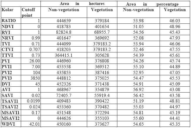 Table 3: Vegetation Indices
Land use analysis: GRDSS through its capability of analyzing the statistical, raster and
vector data with options for map overly, map algebra and other operators aid in analyzing
the landuse pattern. Both supervised and unsupervised classification approaches were
tried to identify landuse categories in the district using Gaussian maximum likelihood
classifier (GMLC). The level of accuracy in GMLC was 94.67% compared to
unsupervised classifier (78.07%). The composition of land use categories (agriculture,
forest, plantation, built-up and wasteland) are listed in the table 4.
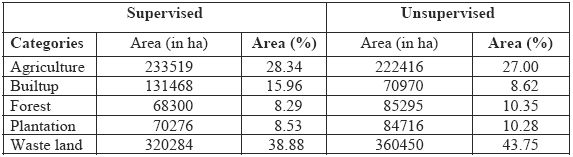 Table 4: Land use details of Kolar district
Accuracy estimation in terms of producer's accuracy, user's accuracy, overall accuracy
and Kappa coefficient were calculated after generating confusion matrix for
supervised classification (table 5) and unsupervised classification (table 6).
coefficient were calculated after generating confusion matrix for
supervised classification (table 5) and unsupervised classification (table 6).
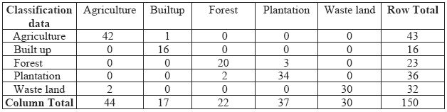 Table 5: Error Matrix Resulting from Classifying Training Set Pixels.
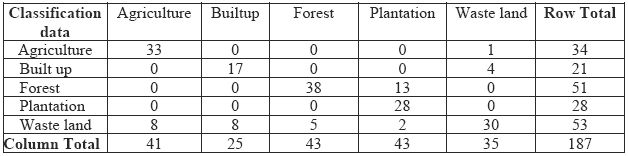 Table 6: Error Matrix for Unsupervised Classification.
The producer’s accuracy, user’s accuracy corresponding to the various categories and overall accuracy results obtained are summarized in table 7.
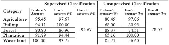 Table 7: Producer’s accuracy, user’s accuracy and overall accuracy.
A value was computed (0.931577) which is as an indication that an observed
classification is 93 percent better than one resulting from a chance.
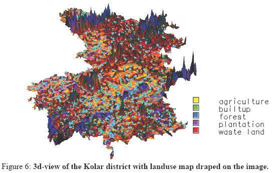
GRDSS was also used to study the watershed status in Kolar district along with land use
and land cover analyses. The digital elevation model generated for the district is depicted
in figure 6. Draping a land use data on the DEM enabled to assess the status of the
catchment of major water bodies. The temporal analysis of Kolar district provided a
picture of land use changes. The analysis indicates the unplanned developmental
activities without proper planning have lead to the conversion of large scale productive
land to waste land (43.75%).
Watershed mismanagement and conversion of waterbodies for various anthropogenic
activities (agriculture, buildings, etc.) were the prime reasons for the depletion of the
water table along with increasing ecological problems such as salinization, runoff, etc.
The land cover and land use analyses showed NRVI, CTVI, PVI1 results are comparable
to GMLC in terms of percentage area. The assessment of the watershed and holistic
approaches in landuse planning considering the actual ground condition could help in
ensuring the sustainable development.
Summary
GRDSS a open source GIS with capabilities such as raster analysis, vector analysis,
image processing, map algebra and other functionalities is comparable to any commercial
software available in the market for various applications including natural resource
management. An economical (free ware) with user friendly GUI’s, GRDSS is hoped to
penetrate in all sections of decision making and contribute to the sustainable development
of India.