|
Landscape Ecology and Biodiversity :
The Western Ghats, one of the well-known biodiversity hotspots of the world, harbours 289 species of freshwater fish of which 119 are endemic. The ecosystems in this region have been, over the past 150 years or so, experiencing tumultuous changes due to the ever-increasing human impacts. In this regard, a study was conducted in Sharavathi River of the central Western Ghats to understand fish species composition with respect to landscape dynamics. The study, using a combination of remote sensing data as well as field investigations shows that the streams having their catchments with high levels of evergreenness and endemic tree species of Western Ghats were also richer in fish diversity and endemism compared to those catchments with other kinds of vegetation. This illustrates that the composition and distribution of fish species have a strong association with the kind of terrestrial landscape elements and the importance of landscape approach to conservation and management of aquatic ecosystems. Occurrence of endangered, endemic species and the discovery of two new species of Schistura genus re-affirm the ‘hottest hotspot’ status of the Western Ghats, a repository of biological wealth of a rare kind, both in its aquatic and terrestrial ecosystems.
- Mapping of endangered, threatened species of flora
- Discovery of two critically endangered tree species
- Discovery of Fish Species - Schistura nagodiensis and S. sharavathiensis
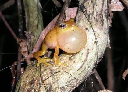
- Discovery of Amphibian - Philautus neelanethrus, Philautus ochlandrae
- Linkage between landscape dynamics and fish diversity
- Direct devlopment mode in bypassing intermediary tadpole stage in Philautus cf. leucorhinus
- Schistura nagodiensis and S. sharavathiensis are the new fish species of Schistura described from Sharavathi river, central Western Ghats.
.gif)
Schistura nagodiensis sp. nov. (SL. 26.0 mm) paratype from type locality, (IISc/CES/WGBIS: 3-5-3-5-007).
.gif)
Schistura sharavathiensis sp. nov. (SL. 32.0 mm) paratype from type locality, (IISc/CES/WGBIS: 3-5-3-5-008).
- A new shrub frog taxon related to the anuran sub-family Rhacophorinae of Rhacophoridae from the Sharavathi River basin of central Western Ghats is described based on the morphological characteristics and diversity in mitochondrial 12S and 16S rRNA genes as Philautus neelanethrus sp.nov. (CES & CCMB, Hyderabad)
- Direct development in amphibians bypassing intermediary tadpole stage has behavioural, evolutionary, and ecological significance. This phenomenon is observed in white nosed shrub frogs, Philautus cf. leucorhinus Lichtenstein and Martens, 1856, is contrary to earlier reports of tadpole stage in its development and only the third species from the Western Ghats to be described completely.
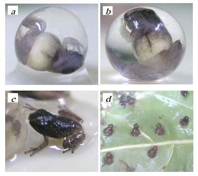
Developmental stages of Philautus cf. leucorhinus till day 19. a,Finger differentiation, limb bends at 384 h; b, Tiny froglet, with reduced tail, at 408 h c, Hatched froglet, at 432 h and d, Froglets at 432 h.
Landscape Dynamics: Biodiversity – Ecology – Hydrology
Landscapes are heterogeneous (group of interacting ecosystems) and differ structurally in the distribution of species, energy, and materials among the patches, corridors and matrix present. Consequently, landscapes differ functionally in the flows of species, energy and materials among these structural landscape elements. Thus, structural and functional aspects along with the changes in the landscape (spatio-temporal) forms core theme of landscape ecological analysis and it hypothesizes that spatial arrangement of ecosystems, habitats or communities has significant ecological implications. The characterization of landscape (shape, size, position and other constituents) can be done using remote sensing in conjugation with Geographical Information System and Global Positioning System. The interactions and flow of species (animals or plants), an energy, water and mineral nutrient among landscape elements emphasizes the focal points within a landscape. And such focal points require special management practices to maintain connectivity, width of the corridors and to avoid breaks and further enhancement of the process. Understanding landscape dynamics has become an important component of ecosystem management as it quantifies the relationship of structural and functional components at various scales.
- Remote sensing data analyses reveal that the western side and south-east region of the river basin are dominated by evergreen to semi-evergreen vegetation. Drainage network analyses reveal higher drainage density and rainfall analyses reveal high intensity rainfall. Classified image and transect based field investigations show large number of evergreen endemics are in western and south-east part of study area.
- Landscape analyses using remote sensing data along with collateral data reveal that vegetation, rainfall and land use are correlated. Occurrences of evergreen to semi-evergreen vegetation region tend to have higher rainfall and perennial streams. The regions with Western Ghats evergreen, endemics tend to retain moisture leading to perennial streams in the region. This helped in evolving restoration strategies to augment water supplies to the Linganamakki reservoir.
|