Temperature: The reservoir has recorded a temperature range of 23.3°- 34°C. The higher values were recorded in the streams and near the shallow banks of the reservoir during the summer period. These extreme conditions make these areas unsuitable for fish species. But the reservoir temperature is optimal for the organisms.
Dissolved oxygen: The hilly terrain favours the oxygenation of the stream water due to high undulations and continuous mixing. The dissolved oxygen concentration ranges from 4.8 to 8 mg/L. The DO Pattern shows systematic variations. The lowest
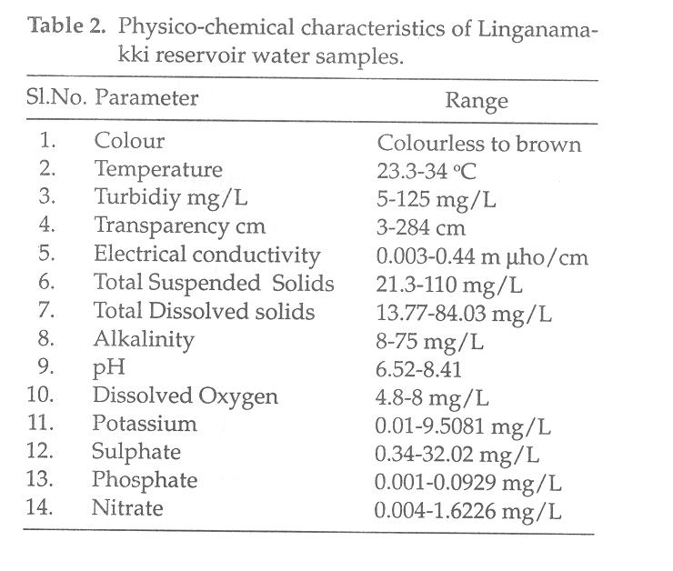 |
concentration was during the dry periods and it increases during monsoon period reaching the peak. This could be due to DO rich water inflow from streams and reservoir, which results in continuous mixing during monsoon periods. Whereas during non monsoon periods, there will be negligible inflow and the reservoir reaches stagnation. Also, the sample collected near Talakalale, which is the outlet point of the reservoir, showed comparatively lower values than other places. This low concentration may be due to the consumption of oxygen by various biotic communities. In the fisheries point of view, the lower values during dry seasons may be harmful, since these values represent the DO at the surface. Naturally it decreases with the depth.
The results of the physico-chemical analysis of the reservoir water samples are as given in Table 2. Overall these values represent the oligotrophic nature of the reservoir and some interference was seen in some of the streams wherein extreme values were obtained.
Rainfall: The region receives more than 250 cm of rain annually. More than 80% of this rainfall takes place during the monsoon months of June to August.
Mean Depth: The water in the dam stays at a height of 55.16m from the lowest riverbed, which is almost equal to the maximum depth of the reservoir. Further, the total capacity of the reservoir is 152 TMcft with area of submergence 326.34 sq.km at full reservoir level of 554.43m. From this data the mean depth of the reservoir comes to about 41.73 meters. This is an excellent representation of a hydel reservoir of hilly region, having deep basin compared to those in the plains with shallow water spread area.
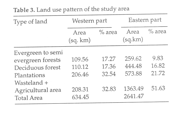
Catchment Area: A close relationship exists between land and water and also aquatic and terrestrial ecosystems. Here an attempt has been made to compare the landuse pattern between western and eastern part of the study area based on remote sensing analysis. The original streamline of river Sharavathi is considered as the dividing line for these two parts. Table 3 shows the individual share of landuse under each landscape element. It is clear that the green cover in terms of evergreen to semievergreen, deciduous and plantation areas is quite high in the western side compared to the eastern side. Similarly, on the eastern side the wasteland and agricultural land is high compared to western side. The catchment area of Sharavathi river is quite low compared to any other rivers of the plain. Naturally, the low catchment area contributes to low nutrients to the reservoir. Table 4 shows the ratio of catchment area and water spread area of some of the reservoirs of Karnataka. This table shows that Linganamakki has the lowest value indicating a small catchment area.
Pollution: Apart from agriculture, all other activities are negligible considering pollution factor. In the catchment area agriculture is the main activity with significant usage of fertilisers and pesticides. These pesticides ultimately reach the reservoir due to runoff. Even though there is no possibility of a high pesticide concentration in the reservoir water, in the higher order organisms like fishes, it becomes significant due to bio-magnification process. Thus, it shows that there is a great need for measuring the effect of pesticides on aquatic organisms.
Phytoplankton status: As such there are no reports on phytoplankton blooms in the reservoir. Phytoplankton sampling was carried out during three summer months in sixteen sampling sites comprising both streams as well as the reservoir. The results revealed a diverse phytoplankton population. The diversity and species richness was more in streams compared to the reservoir.
Zooplankton status: The studies on zooplankton recorded a total of 39 species in different localities of the river basin. Due to the extreme complex nature the species, richness is always very low in the lotic system compared to the lentic water system.