| i. |
Belgaum district |
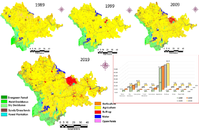
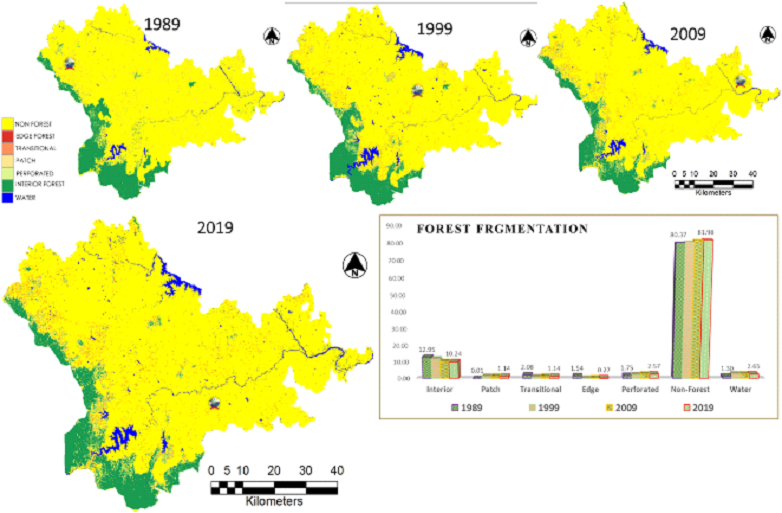
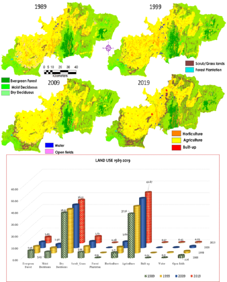
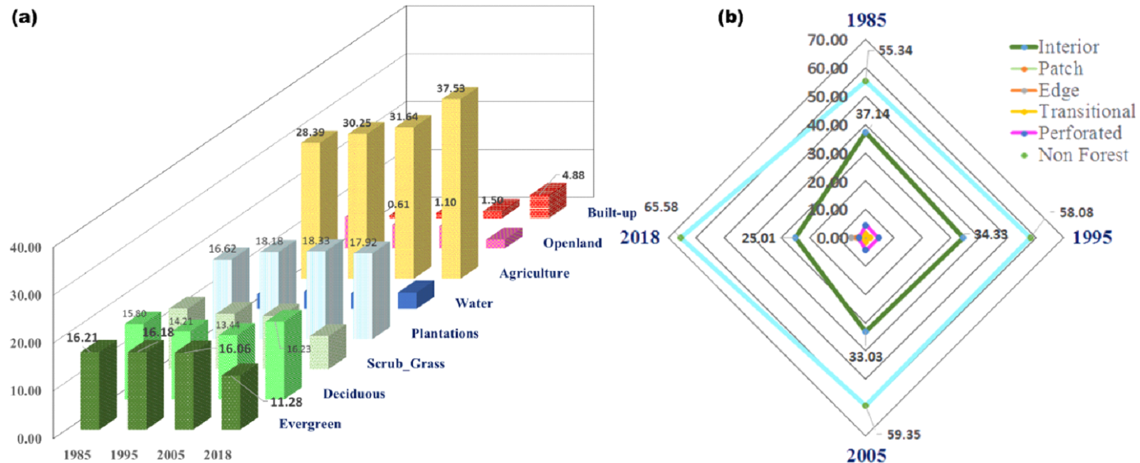
⦁ The land use analysis of Belgaum district shows loss of evergreen forest cover from 7.75 to 5.64% during 1989 to 2019
⦁ The forest fragmentation analysis further reveals the loss of interior forest cover from 14.79 to 6.09 % (1989-2019) noticed with increase in edge, patch, perforated and non-forest cover.
⦁ Modeling the likely changes shows an increase in built-up area by 5.2% by 2019 at the cost of agriculture and forest cover
|
Land use changes in Belgaum |
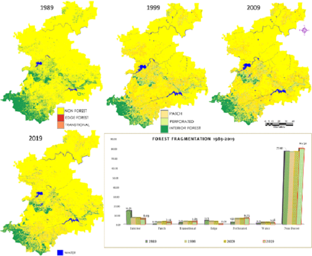
Forest fragmentation during 1989-2019 |
| ii. |
Uttara Kannada district |
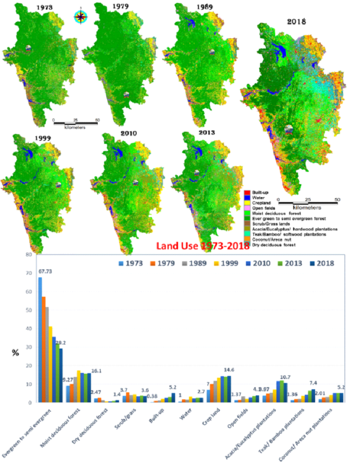
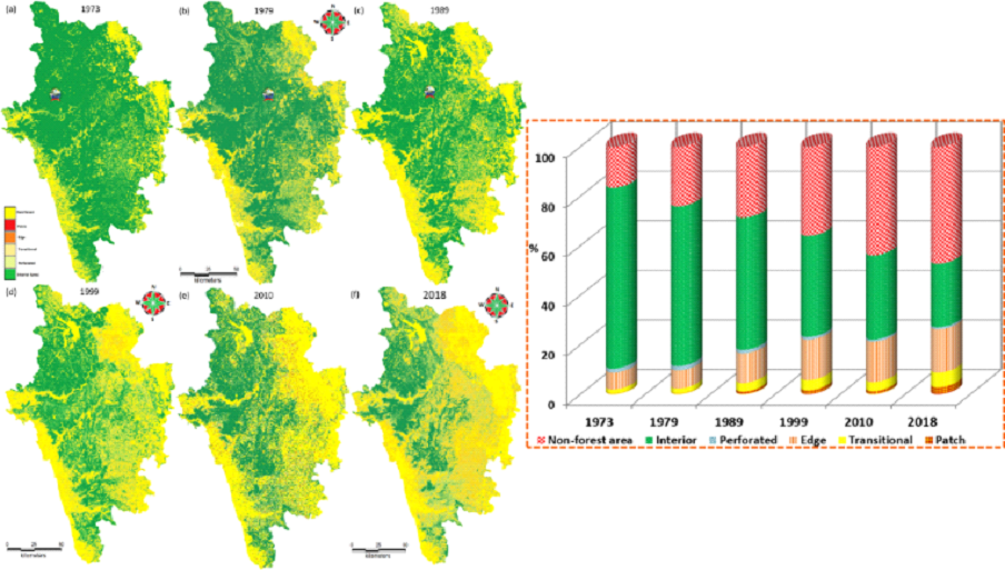
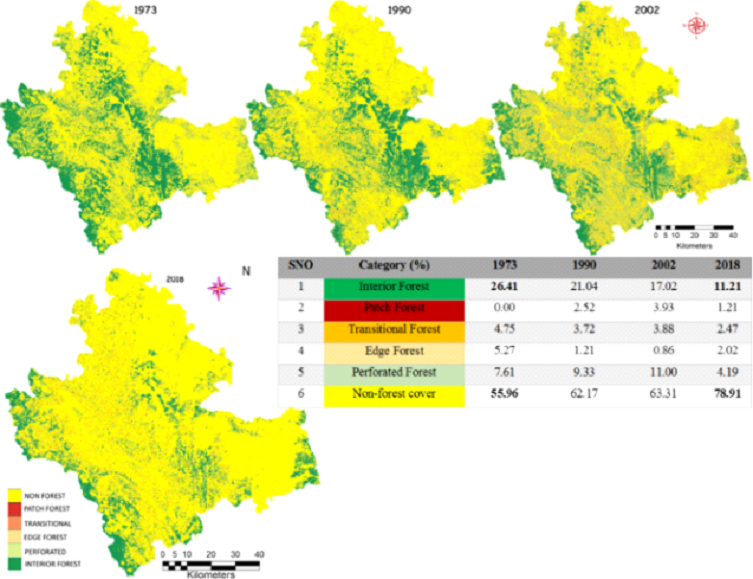
⦁ The evergreen forest cover has declined from 68 to 29% and the area under human habitations have increased during the last four decades, evident from the increase of built-up area from 0.38 to 5.2% (1973-2018). Interior forest has lost from 73 to 22% with increase in edge, patch forest types (Ramachadra et al., 2016; Ramachandra and Bharath, 2018) .
⦁ Simulated likely LU changes highlight the region will have 49% area under forest if the reserve forests are protected or else 45% will be the area under forest. The likely changes might be due to increase in agriculture, horticulture and plantations. The likely increase of built-up cover noticed as 6% and 8.5% by 2022 under two scenarios (Ramachandra et al., 2017) .
|
| |
|
| |
|
| iii. |
Shimoga district |
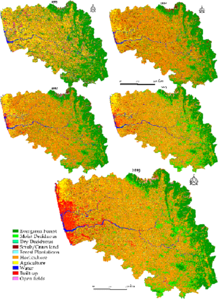
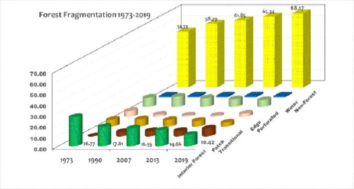
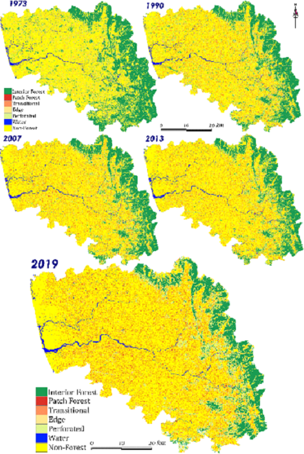
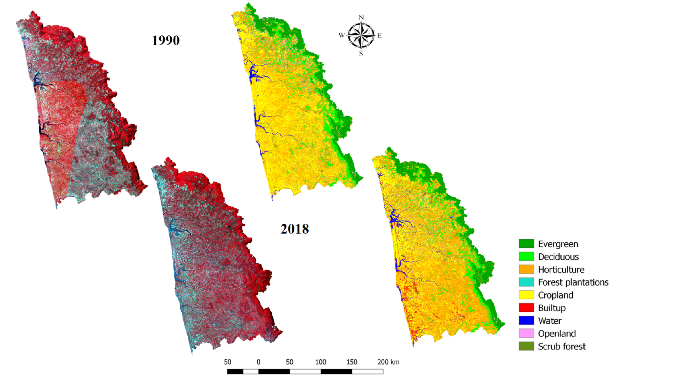
⦁ LU analysis of Shimoga highlights the loss of forest cover from 43.83% (1973) to 34% (2018) with the increase of built-up from 0.63% (1973) to 2.35% (2018), plantations (9 to 30%), industrial and cascaded developmental activities (Ramachandra et al., 2020).
⦁ the loss of interior forest cover (26 to 11%) with increase in non-forest types. The edges and patches have become more prominent due to the disturbances
⦁ The modelling of likely changes highlights the loss of forest cover from 34 to 26 % from 2018 to 2028. The upsurge in built-up cover is noticed from 2.35 to 8% in one decade
|

LU dynamics in Shimoga (1973 to 2018) |
Fragmentation of forests 1973-2018 |
| iv. |
Kodagu district |
⦁ The spatio temporal land use analysis highlights the loss of evergreen cover and increase in built-up and monoculture plantation area. The region had evergreen cover of 40.47 to 24.17 % by 2019. The increase in resorts, buildings, other infrastructure developments have resulted in the increase in built-up cover from 0.42 to 2.34% (Ramachandra et al., 2021) .
⦁ The region had 31.3% intact forest and reduced to 19.7% with increase in non-forest cover and patch forest types.
⦁ The simulation of likely changes for 2031 year depicts the region might have 23% evergreen forest with increase in built-up and monoculture plantation cover (49%).
|

Land Use analysis of Kodagu from 1973 to 2019 |
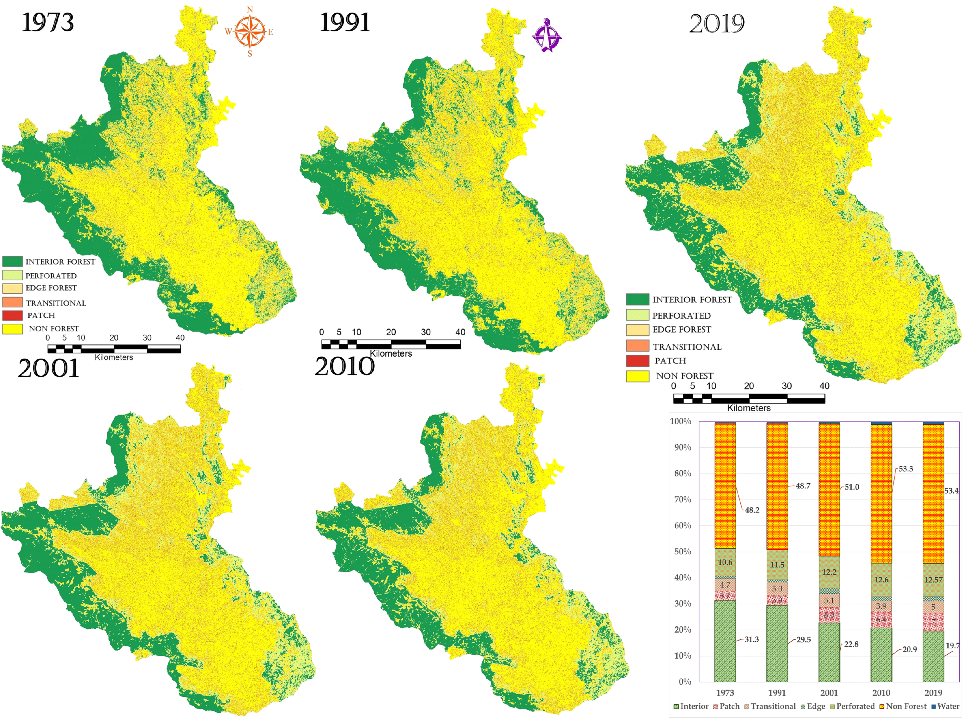
Fragmentation of forests 1973 to 2019 |
| v. |
Chikmagalur district |
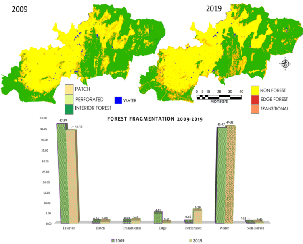
⦁ The increase of built-up patches from 2.55 to 5.16% (2019) is noticed with the loss of evergreen forest cover from 15.28 to 13.81%.
⦁ Forest fragmentation analysis showed the decline of contiguous interior forests from 1985 to 2019 and domination of edge and patch forests. Koppa showed more fragmented forest patches with increased edge and patch forests. The extent of interior forest declined from 30 to 15% during 1985 to 2019. The non-forest cover type is increased from 61 to 65%.
⦁ Forest fragmentation analysis showed decline in forests in Chikmagalur, Kadur, Sringeri taluks due to human alterations in between the forest areas. Decline of interior forest in Mudigere is due to increase in tourism and other developmental activities.
|

Land use dynamics in Chikmagalur |
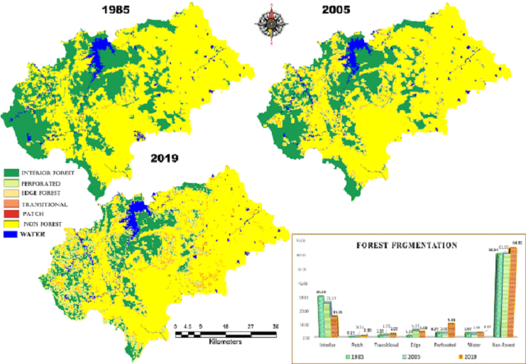
Fragmentation of forests during 1985 to 2019 |
| vi. |
Dakshina Kannada district |
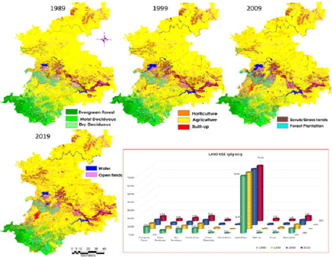
⦁ The district had 35.07% (1973) evergreen cover, reached to 21.91% (2019) with an increase of horticulture from 32.3 to 51.14 %, and built-up cover from 0.49 to 5.95%
⦁ The district had 27% interior forest cover with the least edge and patch forest types in 1973. The degradation has resulted in the loss of interior forest with an increase in the patch, edge forest, and non-forest cover. The interior forests are confined to the mountainous portions of the district and protected areas such as Kudremukh national park, Pushpagiri wildlife sanctuary.
⦁ The increase in non-forest cover from 52 % to 68% has noticed in the last 5 decades.
|
|

Land use dynamics in Dakshina Kannada |
|
Fragmentation of Forests 1973 to 2019 |
| vii. |
Udupi district |
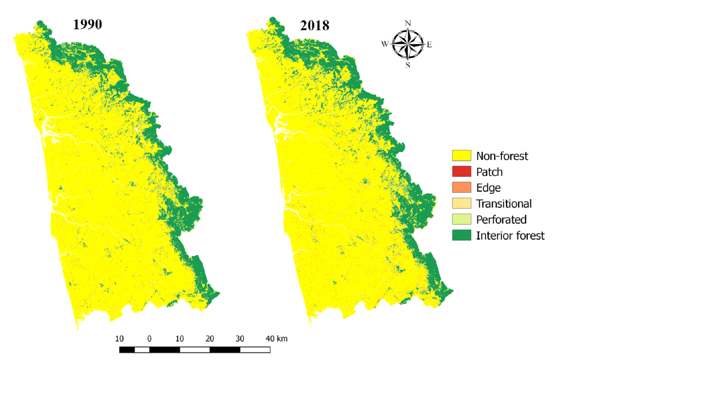
| ⦁ Area under forest cover i.e., evergreen and deciduous, has decreased from 11.63%, 10.47% to 11.38%, 8.37% respectively however, scrub forest increased from 1.85% (1990) to 2.71% (2018). Conversion of agricultural land to commercial use all along the major highways has increased the built-up area (Ramachandra et al., 2021).
⦁ The interior forest has decreased from 17.1% (1990) to 15.9% (2018) while non-forest areas has increased from 75.61% (1990) to 77.14% (2018). Transitional forest has increased from 1.8% (1990) to 1.91% (2018) indicating boundary between interior forest and non-forest has increased.
|
|
|
| viii. |
Mysore |
⦁ The LU analysis highlights the major portion of the district under agriculture (66.57% in 2019) and a loss of moist deciduous forest cover from 3.8 to 2.2 is noticed. The built-up cover has increased from 0.3 to 5 % due to the growth in Mysore city and its sub-urbans.
⦁ The fragmentation analysis further confirms the degradation as interior forest covers only 10% of district forest cover. The perforated patches are increasing 2009-2019 evident from the loss of contiguous patches, which hinders the movement of wildlife.
⦁ Modelling likely changes highlight forest cover will become 13 % by 2029 as compared to 19% (1989).
|
|
|
| ix. |
Chamarajanagara |
⦁ Land use analysis portraits change in deciduous forest cover and increase in scrub forest cover over four decades. The instances of fires in the Bandipur region has transformed large tracts of forests from deciduous to scrub cover. The region has shown increase in agriculture cover 37 to 43%.
⦁ The fragmentation analysis further reveals the loss of intact forest cover from 47 to 44% (2009-2019) and shown increase in edge as well as perforated forests.
⦁ The modeling of LU for 2029 shows increase in built-up area at the cost of agriculture and forest cover.
|
|

|

|
|
| II |
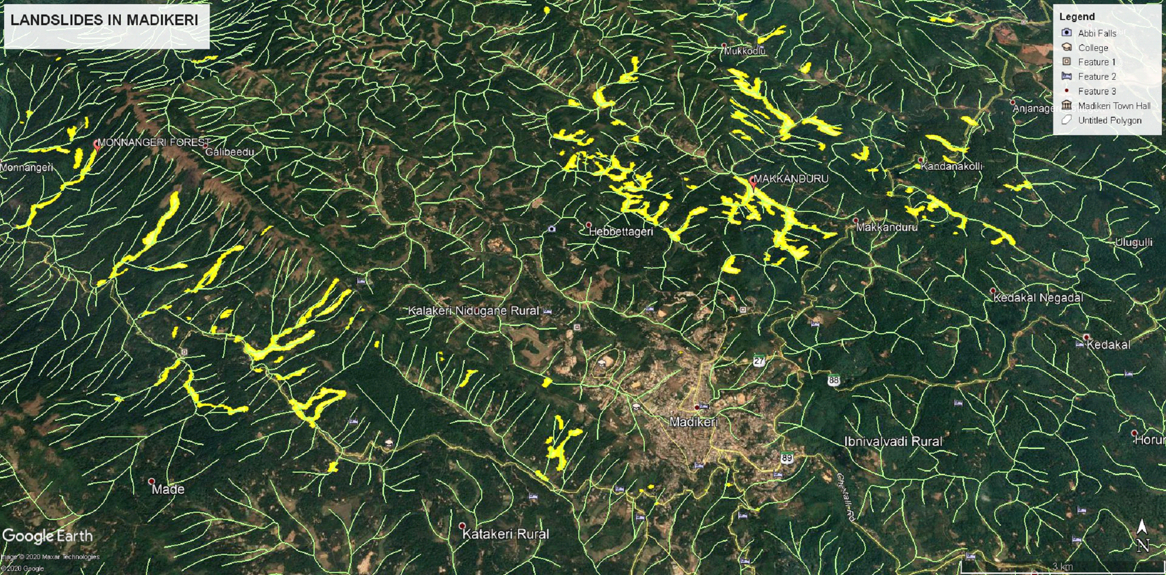
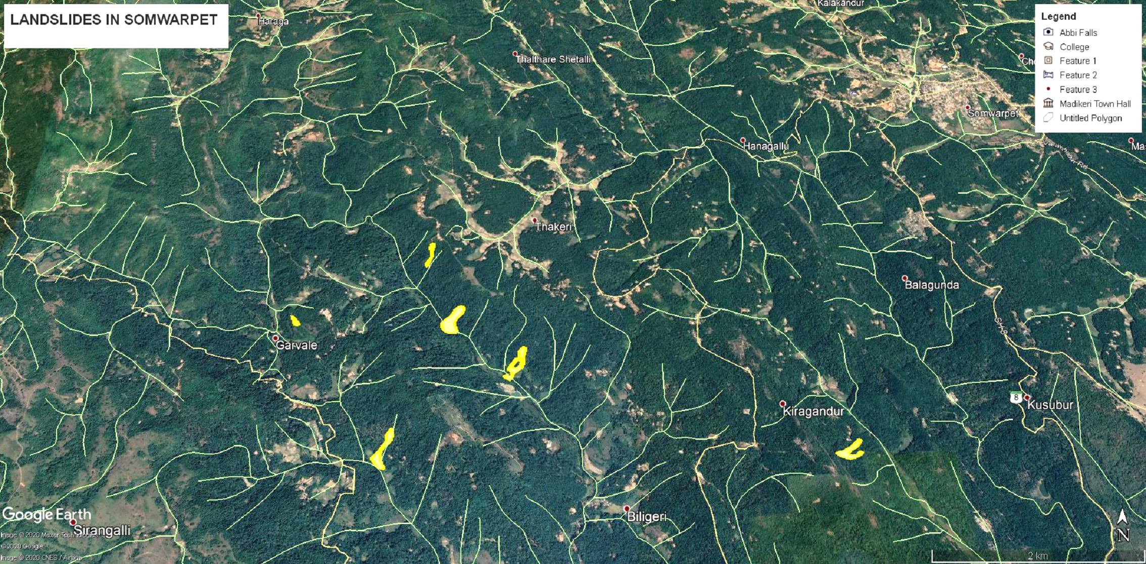
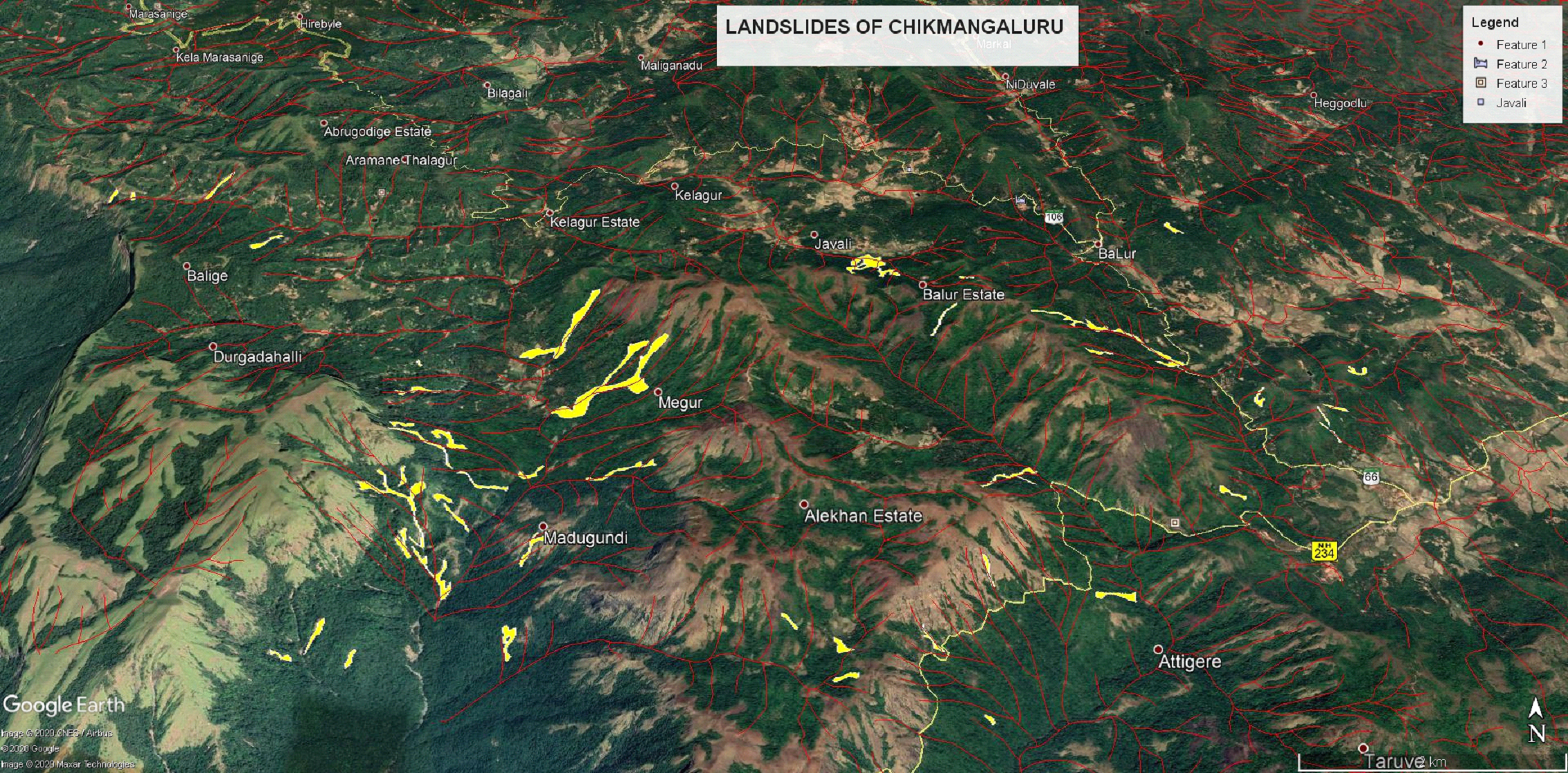
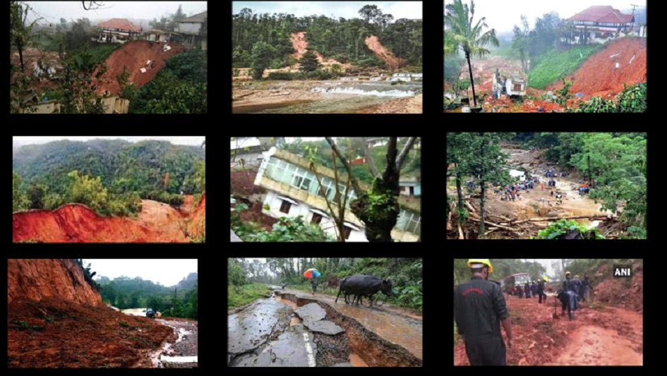
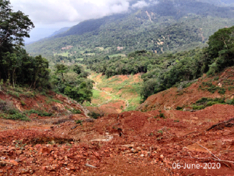
Blockage of streams (hindering natural water flow) leading to poor drainage network in the hilloCks – due to changes in land cover (removal of vegetation or obstruction of drainage channels / streams and construction of resorts, villa’s, etc.
⦁ Landslide oCcurrence correlated with the stream blockages
⦁ Numerous buildings along the path of natural water flow |
|
|
| |
| III. |
Changing climatic regime due to deforestation, precursor to global warming - Large scale land cover changes leading to deforestation in the ecologically fragile Western Ghats, has contributed to an increase of mean temperature of 0.5 0C and decline of rainy days.
⦁ Evident from changes in the precipitation patterns – recurring instances of high intensity precipitation in short duration and reduction in number of rainy days due to changes in the climate. |

Land use dynamics in the Western Ghats |
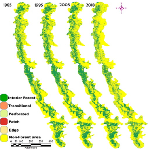
Fragmentation of Forests |

Changes in climatic regime |
|
Global warming with the burgeoning anthropogenic greenhouse gas (GHG) emissions (400 parts per million from 280 ppm CO2 emissions of pre-industrial era) coupled with deforestation has altered climate, eroding the ecosystem productivity and sustenance of water, affecting the livelihood of people. Assessment of LULC dynamics in the Western Ghats using temporal remote sensing data show the decline of evergreen forest by 5% with an increase in agriculture, plantations and built-up area. The interior or intact forests has declined by 10% and are now confined to protected areas. The simulation of likely changes depicts the region will have only 10% evergreen cover and 17% agriculture, 40% plantations and 5% built-up.
The southern Kerala (latitudes of 8-90) shows an increase in temperature from 0.5oC to greater than 1 oC during the past 100 years, while the rainfall has declined by 250 mm and also the decline of rainy days by 2 to 4 days. Latitude 10-12 shows that the temperatures have increased between 0.25 oC to 0.5 oC in a century while rainfall has declined between 100 to 250 mm and decline of rainy days. The analysis indicated that the regions in the southern WG of Kerala, part of Karnataka (8-130) have witnessed large scale climate changes. The Central WG portions (Karnataka) shows less than 0.05 oC increase, while the rainfall shows increasing trends close to 100 mm. The Northern portion of the WG latitudes (16-210) shows increasing temperature of 0.5 degrees and the rainfall has increased between 100 mm and just over 250 mm. This analysis demonstrates that LU has played a major role in moderating microClimatic conditions in WG over a temporal scale. The insights of the current research would help in evolving appropriate mitigation strategies towards sustainable management of forests and mitigate impacts of global warming.
|
| IV. |
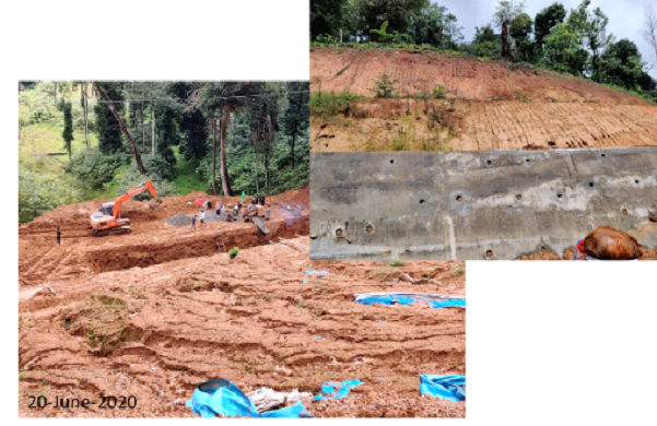
Destabilizing the slope through the removal of the basal support with steep slopes cut for linear projects (roads, pathways, etc.) and residential buildings near the base of the slope |
|
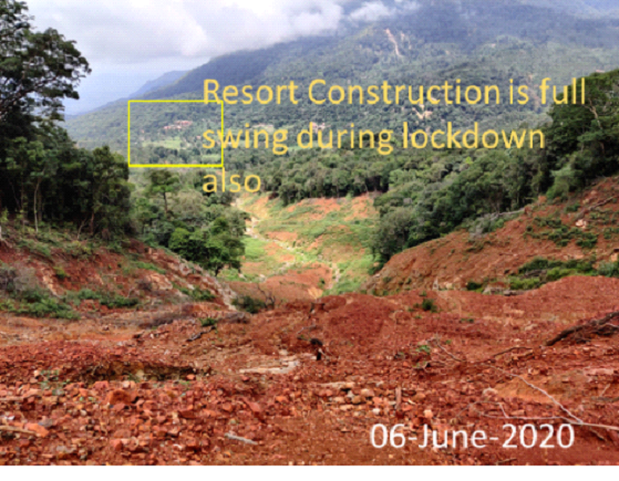
Resorts in ecologically fragile regions - Unregulated tourism |
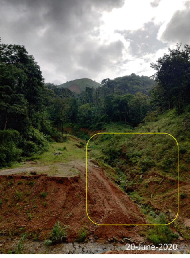
Stream blockage (Diversion for plantation)-Kodagu |
Unscientific mitigation measures-Kodagu |
Stream blockage in Chikmagalur |
 |
A spate of landslides (during the past 15 years) in the coast – due to steep slopes cut, Locations of major landslides in coastal Karwar (overlaid on Google Image by star symbols. Also note the drainage network intensity in the hills. The shore of Arabian Sea all along from south of Baithkol hill is the Sea Bird Naval Base. The habitations are situated between the steep hills, the Arabian Sea, and the Kali River estuary)
|
 Sahyadri ENews: I - LXXVII