|
THE COASTAL REGULATION ZONE (CRZ) FRAMEWORK FOR KARNATAKA COAST: REVIEW
(PDF)
T V Ramachandra, Anirudh Kishore
Energy and Wetlands Research Group,
Centre for Ecological Sciences,
Indian Institute of Science - 560012
1. Introduction
The coast is the interface between the land and sea. These ecosystems include mangroves, coral reefs, estuaries, beaches, etc. Mangroves are a community of salt tolerant plants usually found in the intertidal zones and stagnant swampy coastal waters. Their dense network of roots gives mechanical support to the plants and also traps sediments that flow from the draining rivers. This makes mangroves very effective coastal stabilising agents. The region where a river meets the sea is an estuary. Since freshwater and brackish water are mixing in these regions, they are biologically very active and are understood to be one of the most productive ecosystems in the world. They help in the retention of excess storm water, mitigating floods and serve as natural water purification systems. Estuaries also have mudflats, an ecosystem formed out of the deposition of fine inorganic material and organic debris. Mudflats are rich in invertebrate life and are ecologically very important as they serve as nesting and feeding grounds to many migratory birds. Coastal ecosystems are also considered to be one of the most effective carbon sinks in the world. The beaches are structures located between the lowest low tide level and a landward limit and are formed by the accumulation of unconsolidated sediments transported to the shore by the wave motion. Often found along the landward limit are sand dunes, formed when the sediment transportation through air is obstructed by surface vegetation or any other barrier. Sand dunes are stable structures that provide security to the people living near the coast by acting as a shield against natural calamities that can arise because of climate change. The diversity in their environmental conditions enables them to produce a variety of natural resources that provide beneficial to humans apart from the functions mentioned above. The extraction and utilisation of these natural resources including fishery, fertile soil, bivalves, etc. have helped in securing the livelihood of coastal communities through times.
The coastal zone is a region where land, ocean and atmosphere interact, making it dynamic in nature (Nayak, 2017). This dynamic nature of the regions have led to the formation of diverse ecosystems along the coast including the coral reefs, mangroves, sand dunes, estuaries, creeks and coastal wetlands. The biological productivity and the diversity of floral and faunal species found in coastal ecosystems owing to the different conditions supported by the ecosystems make them unique from other land masses and serve as the main reason for their attractive nature. They harbour a wealth of species and genetic diversity and also perform functions like the storage and recycling of nutrients, water purification and shore stabilisation (Mondal and Bandyopadhyay, 2014). The co-existence of water and land with the constant mixing of saline and fresh water at the coast has been of significant economic value to the humans and remains to be the most exploited geomorphic unit of the earth (Panigrahi and Mohanty, 2012). The economic nature of the coast and the people’s livelihood has been well-documented across different civilisations over the years. The inter-tidal zones where the sea meets the land is not only sustain the livelihood of the local communities, and also beneficial for travel and trade by the sea-routes. The notion of progress and human well-being has been driven by variables such as economic growth, with no challenge for a long time until recently with the notion of sustainable development. The economic prospects pushed communities to the coast, adding to the already existing local communities dependent on it, increasing the pressure on the ecosystems. The coastal regions cover about 10% of the Earth’s land area, and are home to a staggering 60% of the world’s population (Lakshmi and Rajagopalan, 2000) across 123 countries. The rate of extraction of natural resources has almost tripled, with industrialisation, as the extraction of natural resources for domestic purposes was contested by the extraction at much larger rates, rarely scientific, by the industries (Oberle et al., 2019). The unsustainable resource extraction and processing is eroding biodiversity and water. With the growing pressure on the coast to provide for economic gains for the people dependent on it, ecosystems have taken a huge toll because of land reclamation for urban and industrial development, agriculture and mariculture. This is worsened by the pollution that accompanies a growing urban sprawl. These include the eutrophication of water bodies due to excessive untreated organic discharge, contamination of sea food and accumulation of plastic in the water bodies, endangering the marine lives. Coastal zones in most countries are under severe and increasing pressure from rapid urbanisation that comes with over exploitation of coastal resources and continued development in hazard-prone areas (Ajai and Nayak, 2012). The increased dependency on the coast for meeting the demands of maritime trade, expansion of tourism and other recreational facilities and industrialisation has degraded the ecosystems to an extent that 51% of the world’s coasts are now under moderate or high threats of development (Bryant et al., 1995). The degradation of the coast results in a depletion in its quality and quantity with respect to the goods and services provisioned by it. This would mean a decrease in its fish production (and that of other market-based commodities), reduced ability to sequester carbon (mangrove ecosystems), the inability to mitigate natural disaster services, etc.
The increasing pressure on the ecosystems, coupled with their degradation has been posing problems of not just ecological but also of socio-economic nature. The coastal ecosystems, rich in natural resources, contribute approximately one fifth of total global primary production (Mohanty et al., 2008). Traditional methods of extracting resources by local communities over the years are less endangering than that adopted by industries for mass extraction, which has been practiced by the local communities by utilising the natural resources provisioned by the ecosystems. The case is dynamically reversed in the case of industrial extraction where the objective is to make the most profit out of extraction. The labour and monetary capital invested in the process of extraction is only an incurring cost of less significance than the economic output that could be derived from it. The unrest created between the locals and industries as a consequence, increases the competition which increases the rates and extent of extraction. This effect is profoundly felt in the developing countries more so because the local communities are often low income groups that derive the essential resources to run their family from the natural ecosystems. Along the coast, the developing nations have the majority of the growing coastal zone population is found among the lowest
income groups (Sorensen, 2002). The growing inequality among the stakeholders, accompanied by the environmental implications of coastal degradation has necessitated the use of legislative tools in intervening and regulating anthropogenic activities along the coast that are based in sound scientific principles. Internationally, the question of marine resources and marine environmental protection was majorly addressed through the United Nations Convention on the Law of the Sea (UNCLOS). Entering into force in November 1994, this made individual nations responsible for ocean resources through the worldwide adoption of the concept of the 200 miles exclusive economic zone (EEZ). Legislations aimed at ensuring robust health of coastal ecosystems by promoting sustainable management strategies (Nayak, 2017), supported by the administrative set-up and scientific infrastructures in place is necessary to achieve its intended impact on the coastal ecosystems. This involves the collation of information on the coastal resources, habitats, shoreline conditions, anthropogenic activities, coastal vulnerability etc. The information collected, analysed and correlated would support substantial regulating frameworks through informed decision-making. In India, remote sensing data (satellite based information) has been used for generating inventory on coastal resource mapping, landforms, coastal land use and shoreline condition, condition assessment of protected areas, exploration of marine fisheries, mitigation of coastal disasters and understanding of sediment dynamics, etc. (Mondal and Bandyopadhyay, 2014).
2.0 Indian Coast
India’s mainland coast extends to 11,084.5 km, bordered by the Bay of Bengal in the east and south-eat, Indian Ocean in the south and Arabian Sea in the west and south-west. It spans from the Gulf of Kutch in the west, through Kanara in Karnataka, through Cape Comorin, the southernmost region of South India, through the Utkala Kalingal region, to the shoreline near the Sunderbans in the east. The coastal districts with a population of 18.8 crores, contribute to 15.5% of the national population (Census of India, 2011) and it is estimated that nearly one-fourth of the country’s population living within 50 km of the coast (Nayak et al., 2015). The Indian mainland coast consists of 43% sandy beaches, 11% rocky coasts, 36% muddy flats and 10% marshy coast (Central Water Commission, 2016). The east coast is spread across Tamil Nadu, Pondicherry, Andhra Pradesh, Odisha and West Bengal and is dominated by large river deltas and sandy beaches. The west coast spreads across Gujarat, Maharashtra, Daman and Diu, Goa, Karnataka and Kerala with intricate networks of estuaries, backwaters and predominantly rocky coastline. The eastern coastal plain is 80-100 kilometres broad and the western coast is comparatively narrow with a width of 50-65 kilometres (Central Water Commission, 2016). The morphological difference between the east and the west coasts is mainly because of the presence of Western Ghats along the western coast. The long stretch of undulating terrain from Gujarat in the north all the way to Kerala in the south results in an abrupt sloping of the terrain towards the see, making the western coast relatively rocky with sand and sand dunes, which is also the reason for the west coast devoid of major deltas and river estuaries. Compared to this, the east coast being shallow, is largely influenced by major deltas and river estuaries and is mostly dominated by deltaic alluvium (Chandran et al., 2012). With respect to the hydrological regime, the east coast experiences a weak upwelling during the northeast monsoon (October-January), while the west coast is faced with intense upwelling during the southwest monsoon (October-January). The hydro-geomorphological differences between the coasts favour a multitude of coastal and offshore marine ecosystems supporting a diverse biodiversity (Swaminathan et al., 2009) with most of the species endemic to certain areas. Coastal Ecologically Sensitive Areas (CSAs) are home to unique flora and fauna with the coral reefs along supporting over 25% of the marine biodiversity though it constitutes less than 1% of the ocean floor (Nayak et al., 2015). A total of 208 species of protozoan, foraminifera, Tintinnid, dinoflagellate, sponges, cnidarian, Hydrozoa, Siphonophores, polychaetes, Crustacea and Copepoda have been reported along the India coast. There are reports of 2,546 species of fish belonging to 969 genera, 254 families and 40 orders. The reptilian population habited by the coast alone stands at 26 species of sea snakes and 5 species of sea turtles with all 5 nesting on the Indian coast. About 770 species of seaweed (red-184; brown-166; red420) with about 624 marine algal species of various groups are recorded from Indian waters (Swaminathan et al., 2009). The diverse biodiversity found along the Indian coasts gain them the high economic status and the sustained supply of resources is linked to the health of the ecosystems.
3.0 Indian Coastal Ecosystems
The Indian coast owing to the physiological differences that range within the country from the west coast to the east and even along the coasts is home to a range of ecosystems. The tropical climate, and the diverse physiological features within the country (geomorphology, hydrology, ecology etc.) make the coast develop a number of ecosystems, each with their unique biota and corresponding functions. The coastal ecosystems include mangroves, coral reefs, estuaries, beaches, lagoons and islands. The range of ecosystems come together perform biological processes in addition to protecting the coast from vulnerabilities that might arise from the sea and provide livelihood security to nearly one quarter of the Indian population (Swaminathan et al., 2009).
3.1 Mangroves:
Mangrove vegetation are found in the tropical and subtropical coasts globally. They constitute a community of usually woody, evergreen, salt tolerant plants of soft and swampy mud. Usually found in intertidal zones and stagnant swampy coastal waters, they have a dense network of supporting roots that give mechanical support to the tree and trap all the sediments coming in from the streams. Mangrove ecosystems serve as a barrier against storm, providing protection and stability to the coast. Mangroves have special adaptations like physiological and structural mechanisms to thrive in high saline conditions. Mangroves are highly productive system with most of their species commercially important such as king and banana prawns, mud crabs, barramunds, mackrel, mullet, threadfin salmon, bream, whiting, huderikand flatheas. Mangroves in India comprise of 69 species (excluding those of salt marshes and mangrove other associate species, under 42 genera and 27 families. Of these, 63 species (41 genera under 27 families) are present on the East coast; 37 species (25 genera under 16 families) on the West coast; and 44 species (28 genera under 20 families) on the Bay Islands (Chandran et al., 2012). They contribute nutrients to the estuarine-marine ecosystems and are considered to be in the heart of estuarine ecosystem and productivity.
3.2 Estuaries:
Estuaries are the tidal-mouth of the river, forming semi-enclosed coastal water bodies. They are the regions where freshwater from the rivers meet the brackish water and are usually flat expanses of water dotted with small islands and narrow creeks. This unique nature of opening up one end to saline water and the other to fresh water makes estuaries and their associated biodiversity unique. Though they depend on the fresh-water flow from upland rivers to maintain their functions, there is a two-way flow generated with the mixing of fresh and saline water with the continuous variations generating currents. Estuaries are ranked among the highest productive ecosystems globally (Chandran et al., 2012). They serve as spawning, nursery and feeding ground for a number of marine-based life forms and serve as beds for clams, mussels and sea grass. A few of their functions include maintaining coastal stability, salinity, transportation of nutrients and flood mitigation. Estuaries have historically served as fishing grounds and sources for clams and mussels culturing. Estuaries also contain within them deposition of fine inorganic material and organic debris present in debris formed termed as mudflats/ tidal flats. Mudflats are rich in invertebrate life and possess special ecological significance as they serve as nesting grounds and main feeding grounds for many migratory birds.
3.3 Coral reefs :
Coral reefs are three dimensional, shallow water structures dominated by Scleractinian corals and are rich in terms of their biologically diversity. The corals are the largest biogenic calcium carbonate producers and provide substrate for mangrove ecosystems. They also provide habitat to a large variety of flora and fauna, supporting organisms like benthic algae, sea weed, sea grasses, annelids, sponges, crabs, bivalves etc. Even though corals live in nutrient poor waters, their capability to recycle the scarce nutrients (by the whole nutrient community) is enormous. The high productivity is contributed to the efficient retention and recycling of nutrients with the reef system. Coral reefs serve as natural protective barriers against erosion and storm surge by virtue of their formation. In India, coral reefs are mainly found in the Andaman and Nicobar and Lakshadweep islands. On the main land, coral reefs are found in the Palk Bay, Gulf of Mannar, Gulf of Kachchh and Malwan coast. The water body between the circular/semi-circular reef systems and the shore is termed as lagoon.
3.4 Lagoons:
Lagoons are shallow bodies of brackish water partially separated from an adjacent coast by barriers of sand usually. They have narrow openings through the barriers that allow the flow of seawater into the ecosystem. Usually found on low-lying coasts, lagoons are normally aligned to the coast in such a way that their largest diameter runs parallel to the seashore. Being highly productive systems, lagoons have large oscillations in the populations of individual species. This is because, the ecosystem experiences a lot of species migrating to them to take advantage of the considerable production of organic matter and the lack of competition with other species. They function as nursery, breeding and feeding grounds for marine fauna, habitat for mussels and clams and beds for sea grass. Additionally, they influence the shoreline stability by acting as sediment buffers, absorbing the flood waters and wave energy. They provide grounds for the culturing and removal of mussels, shrimps, crabs, fish etc. for human consumption.
3.5 Beaches:
Beaches are structures located between the lowest low tide level and a landward limit, usually defined by a coastal cliff, permanent vegetation or some physical man-made structure. They are formed by the accumulation of unconsolidated sediments transported to the shore and gain a shape over a period of wave generated water motion carrying the sediments. These unconsolidated sediments can range in size from fine-grained sands and mud to rock fragments. Irrespective of the sediments that go into forming a beach, the process in itself is the same across the world. Formed by as an accumulation of unconsolidated sediments, beaches are dynamic landforms, constantly subjected to erosion and/or accretion. Coastal erosion is the landward displacement of the shoreline caused by the wave energy while accretion is deposition of sand on the beaches. They can be caused by the waves and currents from the sea as well as inland sand dune systems that induce erosional and depositional cycles. Sand dunes develop at places where the sediment transportation is obstructed with surface vegetation or any other barrier to the air stream. They range from well vegetated to nonvegetated and from coast parallel to irregular topography. While the fore dunes are in the initial stages of formation and susceptible to removal by storms/high tides, the rear dunes are relatively mature and stable. The stability makes the ecosystem one of the most effective protection against the sea, having them to be the nature’s first line of defence (Chandran et al., 2010). The replacement of sand dunes with walls is a rather regressive effort in strengthening the protection along the coast since the stability of the structure in place is deeply compromised.
4.0 Economic Importance of Indian Coastal Ecosystems
The coastal environment plays a vital role in nation’s economy owing to the different biological processes with the diverse ecosystems. The coastal zones incur competition for its resources from multiple activities and stakeholders (Nayak et al., 2015). The natural resources generation, productive habitats and rich biodiversity found in different ecosystems including the mangroves, coral reefs, sea grasses, sand dunes, lagoons etc. make them important economic biorepositories of the country. Flows from the ecosystem to the humans that are beneficiary to the latter are understood as ecosystem good and services (SEEA-EEA, 2014). The beneficial nature of these flows are necessary to distinguish for the decision regarding conservation against degradation for alternate uses of an ecosystem often hinges on the productive nature of their existence in a strictly economic framework (Kumar et al., 2016). These goods and services are economic in nature and hence, have monetary values hidden, if not direct. Enumerating the value of the existence of an ecosystem can further help in understanding their importance in sustaining the livelihood of the population and the alternative costs that might have to be faced by the government in their absence. Additionally, values of a particular ecosystem from an earlier time to the present can influence the flag points for conservation and restoration strategies. A field in environmental economics looks into the value of such goods and services provided by ecosystems. Services with tangible benefits to the society with market values are termed as provisioning services whereas the regulating, (carbon sequestration, flood mitigation, water purification, micro climate regulation etc.), cultural (recreational, spiritual, cultural etc.) and supporting (soil formation, habitat provision etc.) provide indirect benefits that cannot be measured directly but need proxy variables for the valuation. Marine and coastal ecosystems alone contributed to 32% of the total value of all ecosystems globally, which was estimated to be 33 trillion dollars (Costanza et al., 1997). The values of estuaries (22,838 dollars/ha/year), sea grass (19,004 dollars/ha/year), coral reefs (6,075 dollars/ha/year) and the shelf (1,610 dollars/ha/year) were accounted under coastal ecosystems. The ecosystem services provided of coastal systems was estimated subsequently as 28,917 dollars/ha/year, coastal wetlands at 193,845 dollars/ha/year and coral reefs at 352,916 dollars/ha/year (de Groot et al., 2012).
In an attempt to value the economic worth of coastal and marine ecosystems in India in terms of their beneficial goods and values to humans, a study funded by National Centre for Sustainable Coastal Management (NCSCM) found that the total value of the Indian coast is Rs. 1491.19 billion per annum with the provisioning services coming up to be Rs. 383.06 billion (25.68%) per annum contributed through marine fisheries, seaweed, coastal mineral, coastal salt and water provisioning and regulating services such as carbon sequestration and coastal protection contributing the most (43.93%) (Kumar et al., 2016). A Partial estimate of the recreational value of coastal and marine ecosystems in India without accounting for the consumer surplus reveals that they are worth Rs. 531.8 billion at 2012-13 prices (Mukhopadhyay and Da Costa, 2015). The economic worth of Ashtamudi estuary in Kerala was valued through services including fishery, carbon sequestration, nursery provision and recreational benefits. The net present use value of the estuary was estimated to be Rs. 1923.57 million (Anoop et al., 2008). The option value for the estuary, which is the price people are willing to pay for its optional benefits that might be derived in the future, was valued to at a NPV of Rs. 871 lakhs at a 4% discount rate (Anoop and Suryaprakash, 2008). A detailed study was taken up to value the estuarine ecosystems for the district of Uttara Kannada, Karnataka of the Central Western Ghats region. The total worth of the estuary ecosystems in the district alone was enumerated to be Rs. 1,40,39,296 /ha/year (Ramachandra et al., 2013). The Aghanashini estuary of Kumta taluk was found to be of highly productive and comparatively more intact than estuaries like Kali and Sharavathi due to anthropogenic disturbances to the streams in the form of industrial/domestic discharge and construction of dams specifically in the case of the latter. The economic value of the coral reef systems in Gulf of Kachchh, Gujarat was carried out in the year 2010 (Dixit et al., 2010). The total economic value of the systems were found to be Rs. 79,477/ha/year with the fisheries to be Rs. 4.64 million/year/sq.km of the coral reef area. The economic gain of fishery catch in mangroves as opposed to an alternate landscape was assessed along the south-east coast of India by considering the catches of shellfish and finfish across regions that had different intensity of mangrove cover (Kathiresan and Rajendran, 2002). The difference between an area rich in mangroves as against an area with low and poor mangrove cover with respect to the fishing yield in monetary terms was found to be Rs. 695.4/ha/day. In the state of Odisha, the Bhitarkanika mangrove ecosystem contributed to 14.2% of the overall everyday needs of each household in the surrounding area (Badola and Hussain, 2003). In the state of Gujarat, increasing rates of mangroves degradation prompted a community-based multi-stakeholder initiative under the REMAG (Restoration of Mangroves in Gujarat) project. A study done under the REMAG umbrella revealed that enriched mangrove plantations increased fish catch by 3.923 kg/day with the total value of mangroves if the fisheries and its coastal protection service is weighed in, was found out to be Rs. 9.55 crores/annum or Rs. 1200/ha/year (Das 2016). Studies done on the valuation of coastal ecosystems in India are slowly gaining a lot of interest over the last decade. The realisation of their economic worth would translate to the significance of having them intact, in good health. This approach surpasses the need to make the decision makers or the public understand the scientific worth for their translation in monetary terms is easier to grasp. Table 1 lists the valuation studies for the coastal ecosystems in India.
The diverse ecosystems found along the coast provide for distinct types of ecosystems goods and services that benefit us. The degradation of such ecosystems is majorly because of the anthropogenic pressure and load imposed upon them. On top of unsustainable over-extraction of the resources, the unstained inflow of pollutants deteriorate the ecosystem health. This necessitates awareness on the ecosystem’s diverse nature and economic values with the prudent management approaches through legislative statures promoting environmentally friendly activities and penalising the ones in violation can help in designing effective frameworks that would ensure the path of sustainable development. State issued legislations and directives are often found to be very effective in making the system adapt to a better standard of living, ensuring that the degradation of such natural ecosystems significantly go down with activities and advocacy for their restoration and conservation enter the mainstream only to be a part of a broader framework addressing the nation’s development.
| S.No |
Study Area |
Services evaluated |
Parameters captured |
Approaches involved |
Value |
Unit |
Reference |
| 1 |
Pichavaram mangroves, Tamil Nadu |
Provisioning |
Fishery |
Market price method |
758.2 |
Rs./ha/day |
(Kathiresan & Rajendran, 2002) |
| 2 |
Bhitarkanika Mangrove, Odisha |
Provisioning
Regulating
Regulating |
Fishery
Land accretion
Nutrient retention
Strom protection |
Market price method
Market price method
Market price method
Damage cost avoidance method |
23.85
4,06,9 90
160 million
5340 |
Rs./hour
Rs./year
Rs./acre/year
Rs./household |
(Badola & Hussain, 2003) |
| 3 |
Mangroves along Aghanashin i River estuary, Uttara Kananda, Karnataka |
|
Option Value |
CV - WTP |
1,07,53 |
Rs./year |
(Stone et al., 2008) |
| 4 |
Coral reef systems, Gulf of Kachchh, Gujarat |
Provisioning
Regulating
Cultural
Supporting |
Fishery
Coastal Protection
Tourism
Biodiversity |
Market price method
Damage cost avoidance method
Damage cost avoidance method
Benefit Transfer |
79,477 |
Rs./ha/year |
(Dixit et al., 2010) |
| 5 |
Ashtamudi Estuary, Kollam, Kerala |
|
Option Value |
CV - WTP |
38,84000 |
Rs./year |
(Anoop & Suryaprakash 2008) |
| 6 |
India |
Cultural |
Recreation |
Zonal Travel Cost method |
531.8billion |
Rs./year |
(Mukhopadhyay & Da Costa, 2015) |
| 7 |
Mangroves of Ernakulamand Kannur, Kerala |
|
Option Value |
CV - WTP |
1,10,769 million |
Rs./year |
(Hema & Devi, 2015) |
| 8 |
Estuaries of Karnataka |
Provisioning
Regulating
Cultural
Supporting |
Fishery, Agriculture,Mining (sand and lime shell), Mangroves product harvesting, Salt production Coastal erosioncontrol, Flood control, Strom protection, Carbon sequestration, Disturbance regulation, Gas regulation, Climate regulation, Water supply, Waste treatment, Nutrient retention and cycling, Natural hazard mitigation, Ground ater recharging and Oxygen provision
Coastal erosion control, Flood control, Strom protection, Carbon sequestration, Disturbance regulation, Gas regulation, Climate regulation, Water supply, Waste treatment, Nutrient retention and cycling, Natural hazard mitigation, Ground ater recharging and Oxygen provision
Recreation, Aesthetic, Science and education
Habitat function, Nursery and breeding ground, Biodiversity |
Benefit Transfer |
28,07,852 (Average of all 5 estuaries considered) |
Rs./ha/year |
(Ramachandraet al., 2013) |
| 9 |
Gujarat |
Provisioning
Regulating |
Fishery
Coastal Protection |
Market price method
Damage cost avoidance method |
1200 |
Rs./ha/year |
(Das, 2016) |
| 10 |
Indian coast |
Provisioning |
Marine Fisheries,Seaweeds, Coastal mineral extraction, Coastal salt production, Seawater Desalination, Seawater for Industrial cooling |
Market price method |
1491.19 billion |
Rs./year | (K. S. K. Kumar et al., 2016)
Table 1: Economic valuation of coastal ecosystems in India
5.0 Coastal legislations in India
India is bordered by the Arabian Sea in the west and south-west, Indian Ocean in the south and the Bay of Bengal in the east and south-east with a coast line of 11,084.5 km (NHO, Dehradun). The coastal districts, with a population of 18.8 crore (Census of India, 2011), contribute to about 15.5% of the national population with 4.4 lakh people residing in the island territories. The diversity of resources available along the coast owing to its range of ecosystems such as mangroves, coral reefs, salt marshes and estuaries, along with their associated goods and services makes the coast economically vital to the country’s economy. The tangible goods from fishery (fish, shrimps, bivalves, etc.), timber and a number of non-timber forest products are tradable in markets, while the intangible ones including shoreline stabilization, flood protection, storm water storage and carbon sequestration do not enter the traditional market set-up. The various ecosystems found along the coast with the rivers draining into them have for long supporting the livelihood of a number of communities. They indulge in fishing and aqua-culturing among other activities on an every-day basis to keep their families fed. The revenue generated through coastal tourism, through the recreational and cultural/historic sites, some with national and international significance also contribute to the coasts’ economic importance. Historically, the economic activities facilitated along the coast by the virtue of its diverse natural resources stock which has resulted in dense human habitations across the coast. These diverse ecosystems besides supporting human development, is home to a diverse range of floral and faunal species. Owing to these reasons, it is imperative to consider a sustainable framework that can regulate the magnitude of calamitous anthropogenic activities along the coast.
The health of an ecosystem directly and indirect influences the standard of living. Environmental degradation as a by-product of economic activities is also aided by the prioritisation of the economic outcomes by the state, often materialised in the form of policies (Kulkarni and Ramachandra, 2006). Policy-making in the environmental domain is a multi-disciplinary field that involves the understanding of various aspects of growth including that of the economy in relation to the ecosystems and their health. The United Nations Conference on the Human Environment (famously known as the Stockholm Conference), 1972 was one of UN’s first major conference on international environmental issues. The year 1972 is also regarded as a crucial year for the genesis of environmental legislations and policies in India. During the 24thUNGA of 1972, Mr. PitamberPant, a member of the Planning Commission of India prepared reports on India recognising the impact of population growth on the natural environment. India is a signatory for several international conventions relating to oceans and related activities, some of which are related to marine environment and applicable to coastal area. The important ones include MARPOL 1973/1978; London Dumping Convention, 1972, Convention on Civil Liability for Oil Pollution Damages (CLC 1969) and its Protocol, 1976, Fund, 1971 and its Protocol, 1979, CITES, Convention on Biodiversity, 1992 which includes coastal biodiversity as well.
5.1 Coastal Regulation Zone (CRZ) Notification, 1991:
Coastal legislations in India started taking shape since November 1981 with the then Prime Minister, Indira Gandhi, stipulating a no development zone within 500 m of the high tide line (HTL), keeping in mind the importance of maintaining the beauty and ecological integrity of the coast. The stipulation, however, was an advisory that was sent to the coastal state governments and lacked legislative enforcement. Following this event, the environmentalists engaged in coastal protection collaborated with Maneka Gandhi, the environment minister during 1989-91, to draft a legal framework for coastal protection. The drafted framework was published as the CRZ Notification, 1991 http://environmentclearance.nic.in/writereaddata/SCZMADocument/CRZ%20Notification,%201991.pdf) . Under section 3(1) and section 3(2)(v) of the Environment (Protection) Act, 1986 and Rule 5(3)(d) of Environmental (Protection) Rules, 1986, the notification declared the coastal stretches of the country as coastal regulation zones and regulated activities in the same. The main objective of the notification was to regulate the use of coastal areas for competing anthropogenic uses including housing and industries in order to maintain the ecological viability of these niche spaces (Menon et al., 2015). It declared the coastal stretches of Sea, bays, estuaries, creeks, rivers and backwaters influenced by tidal action up to 500 meters land-ward from the HTL and the land between the HTL and the Low Tide Line (LTL) as CRZ (Coastal Regulation Zone Notification 1991). The prohibited activities include setting up of new industries and expansion of existing industries, manufacture or handling or storage and handling of hazardous substances (except specified petroleum products in port areas), fish processing units, disposal of wastes and effluents, mining of sands, rocks and other rare minerals and mechanized drawing of ground water. It further divided the CRZ area into 4 zones.
(i)CRZ I covered the ecologically sensitive and important areas including conservation reserves, mangroves, coral reefs and breeding and spawning grounds of marine life and thearea between the LTL and HTL.
(ii) CRZ II included areas that were already substantially developed close to the shore-line and were within the municipal limits or legally designated urban areas.
(iii) CRZ III included the relatively undisturbed areas. Areas upto 200 metres from the HTL was marked as ‘No Development Zone’ where no construction was permitted except for repairs of existing authorised structures. No building construction was permitted in CRZ II areas on the seaward side of existing roads/structures with the buildings permitted on thelandward side were subject to the local town and country planning regulations. Inaddressing the already existing traditional communities dependent on the coast, thenotification permitted agriculture, horticulture, gardens and salt manufacturing and the construction of dwelling units between the 200-500 m mark from the HTL.
(iv) CRZ IV zones were the coastal stretches in the Andaman and Nicobar, Lakshadweep andother arid small islands that didn’t already come under the other three zones.
The notification required for all the states to come up with the Coastal Zone Management Plan (CZMP) maps marking the CRZ zones across the entire coast before February 1992 but this process has taken longer time. A Public Interest Ligation (PIL) was filed by the Indian Society for Enviro-Legal Actions that instigated the Supreme Court to force state governments into submitting the CZMPs. Finally, on 27 September 1996, the CZMPs were conditionally approved by the MoEF&CC (Goenka, 2000). The Supreme Court, recognised the overburdening of the state pollution control boards by making them the authorities responsible for the enforcement of the CRZ notification. It ruled that the Central Government should consider setting up state Coastal management authorities under section 3 of the environmental Act and also a national Coastal management authority.
5.2 Coastal Zone Management Authority:
As per the Supreme Court’s direction (Order of W.P. No.664 of 1993), the Ministry had constituted the NCZMA and State CZMA for enforcement and monitoring of the CRZ Notification in the year 1999. These Authorities have been delegated powers under Section 5 of the Environment (Protection) Act, 1986 for taking punitive action against the violations. Its powers and functions include the co-ordination with the State Coastal Zone Management Authorities (SCZMAs), examining of proposals for modifications in the clarification of the coastal zone areas and in the CZMPS received from the CZMAs of the states and union territories, reviewing of cases involving violations of the provisions under the CRZ Notification, provision of technical assistance and guidance to the concerned State Government, Union territory Governments or Administrations, the State Coastal Zone Management Authorities, the Union territory Coastal Zone Management Authorities, and other institutions or organisations in the matters relating to protection and improvement of the coastal environment and serving as an advisory body to the Central Government on policy, planning, research and development and funding in matters relating to Coastal Regulation Zone Management. The NCZMA is followed by the state/union territory Coastal Zone Management Authorities (SCZMAs/UTZMAs). There are a total of 9 SCZMAs and 3 UTCZMAs in India. These institutions are responsible for monitoring and implementing Coastal Regulation Zone rules on a regular basis and the preparation of CMZPs – including mapping the HTL, LTL and the hazard line. Clause 6(c) of the 2011 notification further provides for the constitution of District Level Coastal Committees (DICCs) in all coastal districts though their role isn’t completely defined. The various authorities constituted over different spatial levels helps in streamlining the decision-making process, helping the authorities make better informed decisions. The CRZ Notification was far-reaching in its vision and scope and was a commendable effort by the Ministry of Environment and Forest and Climate Change (MoEf&CC – then MoEF) to bring together all the coastal legislations under one directive, making it was a set of discrete parts with little connection between the tasks and lacked a hierarchical framework that was easy to understand and iterate, unlike the EIA notification. It was a set of independent clauses that were to be taken up in parallel (Menon et al., 2015), making the notification very difficult to implement.
5.3 Issues with the CRZ Notification 1991:
The subsequent amendments to the CRZ 1991 resulted in the dilution of the Notification by permitting more development activities in the CRZ areas (with each amendment). This created unrest among the local communities, especially the fishermen, whose livelihood was threaded by the increased anthropogenic activities along the water bodies as they were polluting the natural environment, resulting in poorer yields. The notification also did not allow for allied fishing facilities such as storage halls, ice factories, fish processing units etc. making the whole process untenable and more cost-intensive. There was no funding mechanism enabled through the Notification for the authorities to take any pro-active measures in the prevention and conservation of the coastal area (Swaminathan et al., 2005). Their jobs become increasingly complex as the stakeholders started conveniently working around the poorly defined terms and definitions in the Notification and it was criticized for lacking a scientific approach. For instance, terms including ‘developed area, substantially built up, relatively undisturbed areas, legally designated urban areas etc.’ were vague and open to interpretations. In July 2004, the Ministry of Environment and Forests set up an Expert Committee headed by Prof. M.S. Swaminathan to carry out a comprehensive review of the CRZ Notification. Its mission was to enable the MoEF to refine coastal regulations on strong scientific principles and to devise regulations that would meet the urgent need for coastal conservation and development/livelihood needs. The vulnerability of the coast was evidently experienced with the tsunami that hit the south-eastern coast of India in December 2004. It demonstrated the vulnerability of the coast and the impacts natural disasters can have on the human and natural capital along the coast, emphasising strongly on the need for developing sustainable coastal management frameworks. The mandate of the committee was to suggest scientific principles for an integrated coastal zone management (ICZM) plan for India, recommendation of methodologies to be followed for the conservation and protection of the coastal and marine resources and recommendations of amendments to the CRZ notification and the regulatory framework. Significant principal recommendations were the rationalization of management boundaries based on the coastal vulnerability of a place, making management of coasts local-centric, moving away from a regulatory framework and adapting to a management framework and creation of institutional infrastructure specifically geared to address coastal management issues and practices scientifically. It proposed the establishment of a National Institute for Sustainable Coastal Zone Management, an All India co-ordinated research project on ICZM and a separate division under MoEF&CC dedicated to coastal management issues. This report highlights the dilution of the law, lack of implementation of the same by the states and lack of resources and infrastructure required for the implementation (Sridhar et al., 2006).
5.4 Draft Coastal Management Zone Notification, 2008:
Following the recommendations of the committee, the Central Government issued a draft Coastal Management Zone (CMZ) Notification(http://environmentclearance.nic.in/writereaddata/SCZMADocument/Island%20Protection%20Z one%20Notfication,%202011.pdf) in the year 2008 with guidelines provided for the management and permitted activities along the coast. The draft CMZ notification, received a widespread objections from the stakeholders - environmentalists, fishermen communities and scientists across all the coastal states, for not consulting the stakeholders. The sustained resistance from the stakeholders forced to keep the notification in abeyance till mechanisms are put in place that can lead to inclusive management efforts integrating the coastal communities’ opinions and knowledge by facilitating their active involvement in the decision-making processes. On June 15, 2009, the ministry constituted a four-member Committee under the Chairmanship of Prof M S Swaminathan to recommend future steps on the draft Coastal Management Zone (CMZ) Notification, 2008. The Terms of Reference (TOR) set for the committee were to examine the various comments received on the draft CMZ Notification, 2008 and advice on the policy and legal framework required for ICZM. The draft Notification’s suggestion to map the setback line was fraught with scientific and data problems that would’ve lead to delays in its implementation. The terms and proposals were also criticized for not being adequately defined, opening them up to selective interpretation. One of the biggest concerns that was shared by all the coastal states is that during the interim period, a huge number of development activities by some interested parties might be taken up with the hope that they might get legalised as the Plan gets approved. Taking all these gaps into consideration, the committee recommended that the ministry continues with the existing CRZ Notification, 1991 with the incorporation of certain aspects from the draft CMZ Notification as seen beneficial and that the CMZ Notification should be allowed to lapse (Swaminathan et al., 2009). As recommended, the CMZ Notification was allowed to lapse with the ministry concentrating of the process of modifying the existing framework of the CRZ Notification in such a way that the alternations can include the best practices, as identified through the CRZ and CMA Notifications and the expert committee's recommendations. It ensured that the decision-making involving the participation of all the stakeholders including the government authorities, scientific institutions and the local communities.
5.5 Coastal Regulation Zone Notification, 2011:
waminathan committee suggested that the CRZ 1991 should be modified to include the seaward side as well so that port-related activities can be regulated based in their impact on the sea. It also suggested the introduction of new management regimes in islands as having a uniform distance of 500 m across small islands would translate to the entire landmass being notified under CRZ, which could potentially be problematic for the island-dwellers in the absence of management plans (Swaminathan et al., 2009). A few more significant suggestions included the need for the strengthening of the mangrove areas through more rigorous mapping and scientific conservation efforts, declaration of regions that required further protection as Critically Vulnerable Coastal Areas (CVCAs) and the security of the rights and as a consequence, the livelihood of local communities living along the coast who have historically depended on it for sustaining themselves. The committee further recommended the use of satellite and information technology to map and monitor the coast in real-time like how it was implemented in the state of Goa. Importantly, it addressed the need to build capacity of the SCZMAs by building information sources for better decision-making as the main problem that was faced by the coastal zone management legislations were the lack of scientific institutional capacity. In the year 2010, with the intention of implementing the National Environment Policy, the Government of India (GOI) embarked upon the World-Bank funded Integrated Coastal Zone Management (ICZM) project. The Society for Integrated Coastal Management (SICOM), established under the Society Registration Act, 1986 by the MoEF&CC, was responsible for its implementation. The SICOM established the National Centre for Sustainable Coastal Management (NCSCM) in the same year with the vision of promoting sustainable coastal practices through increased partnerships, conservation practices, scientific research and knowledge management and to further assist MoEF&CC and the states in the implementation of the CRZ directives. On January 7, 2011, after a series of public consultations in all coastal states that deliberated the draft CRZ Notification 2011 and the suggestions made by the Swaminathan committee, the ministry issued the Coastal Regulation Zone Notification, 2011.
The CRZ 2011 was implemented with a view to ensure livelihood security to the fishermen communities and other local communities living along the coast, protect and conserve the coastal ecosystems and to promote sustainable development based in scientific principles. It declared the coastal stretches of the country, including the water area up to its territorial water limit, excluding the islands of Andaman and Nicobar and Lakshadweep and the marine areas surrounding these islands up to its territorial limit, as Coastal Regulation Zone (Coastal Regulation Zone Notification, 2011). The task of delineation of the HTL and LTL, which would form the baseline for the preparation of CZMP maps, was given to the NCSCM, which was earlier done by the Naval Hydrographic department. Significant deviations from the 1991 Notification are the reduction of ‘No Development Zone’ from 200 m to 100 m from the HTL to meet the increased demands of housing of the local communities and the modification of the CRZ IV to include the bed area between the LTL to the waters between the LTL to the territorial water limit of 12 nautical miles seawards. In addition, the Island Protection Zone (IPZ) Notification, 2011 (http://environmentclearance.nic.in/writereaddata/SCZMADocument/Island%20Protection%20Zone%20Notfication,%202011.pdf) was notified and published covering Andaman and Nicobar Islands and Lakshadweep as opposed to having them addressed as a part of the CRZ Notification. The Notification made special provisions for Goa, Kerala, and Greater Mumbai and included Critically Vulnerable Coastal Areas (CVCAs), as recommended by the Swaminathan committee. These CVCAs are areas that crucially require protection and conservation and include Karwar and Kundapur taluks of Karnataka, Vembnad, Kerala and the Gulf of Khambat and Kutch, Gurajrat along the west coast. Picking up from the suggestion made by the M.S. Swaminathan expert committee report on the conservation of mangroves, the Notification mandates a provision of 50 m buffer for mangroves (CRZ-I) spreading over an area of 1000 square metres. It made the procedures for obtaining CRZ approval clear with the timelines stipulated along with the postclearance monitoring and enforcement mechanisms. For the clearance of a project, the proponent is required to prepare a CRZ map indicating the CRZ-I, II, III and IV areas including other notified ESAs, normally covering 7 km radius around the project site, with the are covered by the project overlaid which will be reviewed by the concerned CZMA, the recommendations of which will be considered by the MoEF&CC or SEIAA for clearance. It required for the shorelines to be mapped through time-series satellite image with no foreshore development permitted in high-eroding areas. In addition to the NCZMA and SCZMAs/UTCZMAs, the 2011 Notification, under Clause 6(c) suggests the constitution of district level Committee chaired by the District Magistrate containing at least three representatives of local traditional coastal communities including from fishermen to ensure the involvement of all stakeholders in the decision-making process. Notably, Tamil Nadu and Karnataka had district level committees even prior to the CRZ 2011.
The CRZ Notification 2011, however, lacked implementation on ground owing to the short-staffed nature of the CZMAs in the states and union territories to monitor and regulate the development along the zones. Clause 5 (vi) of the Notification required the states and union territories to prepare and submit the draft CZMP maps in 1:25,000 scale along with their recommendations in a twenty four month period from the issued date. The timeline issued, however, was extended 4 times through amendments up until 2016. The CZMAs also indicated that the preparation time was affected due to the lack of data, expertise and institutional help adding to the manpower. The added pressure on the coastal ecosystems to provide for goods and services to the growing population along the coast coupled with the excessive degradation majorly in the form of land and water pollution was detrimental to the ecosystems. With the increasing rates of degradation and vulnerability of the coast to climate changes, the government wanted to elicit the limitations with the CRZ 2011 and the various issues in its implementation state-wise. This lead to the constitution of a six-member Committee on June 17, 2014 under the chairmanship of Dr. Shailesh Nayak, then Secretary, Ministry of Earth Sciences. It recognised that the existing staff was actively able to address only the violations along CRZ II and III and weren’t able to take any pro-active steps in CRZ I and IV areas for conservation. The Committee examined it in detail and observed that several of the activities listed under prohibited activities, due to the exemptions, led to ambiguity among the stakeholder (Nayak et al., 2015). It further identified that some activities relating to industries are governed by Acts and legislations outside of CRZ 2011 and that this overlap should be avoided and that the Acts in themselves should be strengthened by including clauses that specifically address their functioning along the coast. In recognising the lack of resources for CZMAs to effectively monitor and regulate the directive, the committee suggested that SICOM should set up appropriate mechanisms for the enforcement of coastal regulations. On the socio-economic front,
(i) the hardship faced by the local communities due to the restrictions imposed on housing, development and tourism
(ii) the increasing pressure on the ecosystems to sustain their livelihood. In view of these issues, the committee suggested that the Notification be recast and that a fresh notification shall be considered by the Government, super-seeding the 2011 Notification.
5.6 Coastal Regulation Zone Notification 2019:
The Shailesh Committee recommended that the MoEF&CC may formulate concrete proposals and initiate activities for the conservation and protection of the coastal ecosystems as they are of immense importance in regulating the coastal environment and securing of the local communities’ livelihood. Sensitisation drives for the CZMAs on the importance of the coastal ecosystems can help them engage in more pro-active measures in the CRZ 1 and IV areas more effectively. In order to promote economic activities along the coast that can reduce the pressure on ecosystems, the committee identified that the ecosystems can attract tourism if properly managed. It also held that new opportunities and initiatives are needed to address the socio-economic development along the coast. This report lead to amends being made to the CRZ 2011 to promote development along the coast with little concernto the already existing violations along the coast., 3 amendments were made that were prodevelopment in 2015. The recommendations along with the proposed draft CRZ Notification 2018 (http://envfor.nic.in/sites/default/files/press-releases/DRAFT%20CRZ%20NOTIFICATION%2020181.pdf) were considered for the preparation of a fresh notification. The draft notification, however, was strongly criticised for its pro-development stand along the coast even though it places a lot of weight on the importance of the coastal ecosystem and their conservation. In the guise of sustainable development, the draft suggested the coast will be opened up industry, real-estate and tourism. The Central Government, in 19 thJanuary, 2019, after considering the views of the stakeholders on the draft, issued the Coastal Regulation Zone Notification 2019 (http://envfor.nic.in/sites/default/files/GSR%2037(E)%20DATED%2018.01.2019.pdf).
The changes brought about in the notification will promote affordable housing, thereby accommodating the people at large looking for shelter. Tourism, identified through the notification to be one of the greatest creators of livelihood and jobs, will be boosted, leading to more infrastructure, especially surrounding the ESAs and ecosystems covered under CRZ I at large. In addressing the growing population and its demand, the Floor Space Index (FSI), which had been frozen since the 1991 notification, has been undone by the 2019 Notification, which permits an extension of the FSI with the intention of enabling redevelopment of the coastal areas. To aggravate the environmental consequences of the above mentioned changes, the Notification further divides CRZ III into CRZ – III A and B depending on the population density where CRZ III-A is densely populated with a density of 2161 persons per square kilometre in accordance tothe 2011 Census. The No Development Zone in these regions have been reduced 200 meters fromthe HTL to only 50 meters. With respect to the conservation of coastal ecosystems, all ESAs have been accorded special importance with specific guidelines related to their conservation and management plans being drawn as a part of the notification. A few of them include the rejuvenation and rehabilitation of dead/destroyed coral areas, protection of mangroves and their buffer areas though detailed plans prepared by the Government, efforts to increase the forest area to aid better in mitigating natural disasters like floods and the identification and protection of turtle nesting grounds as per Wildlife Protection) Act of 1972. However, the emphasis placed on the importance of protecting and conserving the ecosystem is directly challenged by the mechanisms introduced in promoting socio-economic activities along the coast. Though the Shailesh Committee urges on the need for immediate stringent measures to counter the growing pollution levels and illegal encroachments in the CRZ I areas, the efficiency with which these recommendations would be implemented remains to be uncertain given the trends of pollution rates and the effectiveness with which it has been handled over the last few decade.
6.0 Chronology of CRZ Notifications, India
In this section, the chronology of the CRZ Notifications, from their inception, throughtheir amendments, to the recent 2019 notification has been tabulated (Table 2).
| Year |
Date |
Event |
Significant outcomes |
| 1972 |
|
24th United Nations General Assembly (UNGA) meet |
India recognises the impact of population growth the natural environment |
| 1986 |
23-May |
Environment Protection Act (EPA) |
Enacted to implement decisions taken at the UN conference on the Human Environment |
| 1981 |
|
Advisory sent by the then PrimMinister Mrs. Indira Gandhi to thcoastal state governments |
Stipulation of a No Development Zone (NDZ) within 500m of the HTL along the coast |
| 1984 |
March |
Guidelines circulated by the Department of Environment |
Guidelines suggested that environmental impact assessment studies should be carried for any form of developmental project |
| 1990 |
15 - Dec |
S.O. 114(E) - Draft CRZ Notification issued by MoEF& CC (previously known as MoEF) |
Invited suggestions and objections from public on the to-be-implemented directive on coastal zone management |
| 1991 |
19 - Feb |
CRZ Notification 1991 |
Declared 500 m on the landward side from HTL and the area between the HTL and LTL as Coastal Regulation Zones and regulated the activities in the CRZ areas |
| 1994 |
18 - Aug |
S.O. 595(E) - Amendment to the CRZ Notification 1991 |
Relaxed CRZ area to 50 meters along the tidal influenced water bodies |
| 1997 |
31 - Jan |
S.O. 73(E) - Amendment to the CRZ Notification 1991 |
Permitted mining of sand and drawal of groundwater in the CRZ area in Andaman and Nicobar |
| 1997 |
09 - jul |
S.O. 494(E) - Amendment to the CRZ Notification 1991 |
Permitted reclamation within port limits constructions for operation, expansion and modernization of ports |
| 1999 |
|
Constitution of NCZMA and SCMZAs/UTCZMAs by the MoEF&CC as per the S.O.664 of 1993 |
Authorities delegated powers under Section 5 of EPA (1986) to regulate and monitor the activities along the coast in line with the CRZ Notification |
| 2000 |
04 - Aug; |
S.O. 730(E) - Amendment to the CRZ Notification 1991 |
Permitted storage of LNG in the inter-tidal area and exploration and extraction of oil and gas in CRZ areas |
| 2001 |
12-Apr |
S.O. 329(E) - Amendment to the CRZ Notification 1991 |
Permitting setting up of projects and Department of Atomic Energy, Pipelines and conveying systems in CRZ areas |
| 2002 |
21-May |
S.O. 329(E) - Amendment to the CRZ Notification 1991 |
Permitted non polluting industries in the field of IT and other service industries in the CRZ areas of special economic zones |
| 2002 |
19-Oct |
S.O. 110(E) - Amendment to the CRZ Notification 1991 |
Permitted non conventional energy facilities, desalination plants, air strips in Coastal Regulation Zone of A&N and Lakshadweep. Storage of non-hazardous cargo such as edible oil, fertilizer and food grain was also permitted |
| 2003 |
22-Apr |
S.O. 460(E) - Amendment to the CRZ Notification 1991 |
Project costing more than 5 crores requires clearance from Ministry of Environment and Forests |
| 2003 |
30-May |
S.O. 636 (E) - Amendment to the CRZ Notification 1991 |
Permitted construction of embankment facilities for Lakshadweep in Coastal Regulation Zone –I areas |
| 2003 |
24-Jun |
S.O. 725(E) - Amendment to the CRZ Notification 1991 |
Permitted construction of trans-harbour sea linkspassing through Coastal Regulation Zone –I areas |
| 2003 |
24-Jul |
S.O. 838(E) - Amendment to the CRZ Notification 1991 |
Relaxed No Development Zone to 50 mts from 200 mts from HTL in A& N and Lakshadweep for promoting tourism |
| 2004 |
|
M.S. Swaminathan Committee appointed by the MoEF& CC |
Having identified the need for a scientific basis for the coastal management and regulation of activities along the coast, the committee was formed to review the CRZ Notification; its recommendations included the zonation of a vulnerability line, inclusion of territorial waters in the CRZ Zones and changes in the boundaries among others. |
| 2005 |
25-Jan |
S.O. 86(E) - Amendment to the CRZ Notification 1991 |
Permitted sand mining for construction purpose on a case to case basis in the UT of Andaman and Nicobar islands |
| 2007 |
26-Mar |
S.O. 451(E) - Amendment to the CRZ Notification 1991 |
Permitted the setting up of facilities to store fertilizers and raw materials required for manufacturing in addition to the petroleum products and chemicals |
| 2008 |
01-May |
Draft Coastal Managament Zone (CMZ) notification 2008 |
repared in line with the recommendations from the M.S. Swaminathan report, the draft CMZ notification was faced with a lot of protests from the civil society and fishermen at large triggered by the permitted activities along the coast |
| 2009 |
15-May |
S.O. 1243(E) - Amendment to the CRZ Notification 1991 |
Permitted the development of green field Airport at Navi Mumbai subject to detailed scientific study for incorporating adequate environmental safeguard measures |
| 2009 |
15-Jun |
Expert committee chaired by Dr. M.S. Swaminathan constituted by the MoEF&CC |
This 4-member committee was formed to recommend future steps on the draft CMZ Notification of 2008 and to advise the government on the policy and legal framework for Integrated Coastal Zone Management (ICZM); It recommended that the draft CMZ notification be allowed to lapse, keeping the CRZ Notification 1991 as the basic framework with suitable alterations to address the sea level rise induced by climate change and the growing pressure of population on coastal resources and biodiversity |
| 2010 |
|
Establishment of SICOM (Society for Integrated Coastal Management) |
SOCIM was established under the Society Registration Act, 1986 by the MoEF&CC which works as a National Project Management Unit for the ICZM Project |
| 2010 |
|
Establishment of NCSCM (National Centre for Sustainable Coastal Management) |
NCSCM established by SICOM under MoEF&CC with the vision of promoting sustainable coastal practices through increased stakeholdersparticipation, conservation practices based in scientific research and knowledge management and to assist MoEF& CC and the states in implementing the CRZ Notification more effectively |
| 2010 |
Sept |
ICZM Project Phase 1 |
The MoEF&CC, through SICOM (Society forIntegrated Coastal Management) embarked on the World Bank funded ICZM project for India;Comprehensive aerial photography work, sedimentcell mapping, Ecologically Sensitive Areas (ESAs) and shoreline changes were mapped for the entire Indian coast; Gujarat, Odisha and West Bengalselected for the preparation of ICZM plans based inscientific data and in consultation with thestakeholders |
| 2010 |
15-Sep |
S.O.2291 (E) - Draft CRZ Notification 2011 |
A series of public consultations were held in all coastal states prior to the announcement of the draft in early March, 2010 which was then integrated in the Draft CRZ Notification issued in September |
| 2011 |
07-Jan |
CRZ Notification 2011 |
Taking recommendations from the M.S. Swaminathan Committee 2009, the CRZ Notification 2011 was issued. The main objectives of the notification included the security of the livelihood of fisherman and other local communities dependent on the coast, conservation and projection of the coastal environment and to promote sustainable development practices |
| 2013 |
22-Aug |
S.O. 1244(E) - Amendment to the CRZ Notification 2011 |
Revised its position on the CZMP maps fromallowing the State/UT CZMAs to continue with the already approved maps till 31st January, 2014 toasking them to submit the draft CZMPs along with its recommendations on or before 30th September, 2013 |
| 2014 |
30-Apr |
S.O. 2557(E) - Amendment to the CRZ Notification 2011 |
Extension for the submission of CZMP maps till 30th September, 2015 |
| 2014 |
17-Jun |
Committee chaired by Dr. ShaileshcNayak constituted by the MoEF& CC |
The 6-member committee had sittings with the Governments of Maharashtra, Karnataka and Kerala and also critically examined the CRZ notification 2011 to highlight the issues in its framework and execution. Along with recommending improvements to the Notification, the committee suggested that it should be recast and that a fresh notification should be considered by the government. |
| 2014 |
28-Nov |
S.O. 3085(E) - Amendment to the CRZ Notification 2011 |
Inclusion of 'salt works' under activities regulated under the CRZ provision; Activities requiring EIA clearance had to be screened by the CZMA and only then recommended to the MoEF&CC for consideration |
| 2015 |
17-Feb |
S.O. 556(E) - Amendment to the CRZ Notification 2011 |
Permitted the construction of memorials/monuments by the concerned State Governments in CRZ IV (A) areas with adequate environmental safeguards implemented |
| 2015 |
31-Mar |
S.O. 938(E) - Amendment to the CRZ Notification 2011 |
Extension for the submission of CZMP maps till 31st January, 2016 |
| 2015 |
30-Dec |
S.O. 3552(E) - Amendment to the CRZ Notification 2011 |
Permitted land reclamation in case of roads being built on surface provided they are not authorised for permitting development on the landward side |
| 2016 |
22-Mar |
S.O. 1212(E) - Amendment to the CRZ Notification 2011 |
Extension for the submission of CZMP maps till 31st January, 2017 |
|
| 2019 |
19-Jan |
CRZ Notification 2019 |
The recommendations made by the Shailesh Nayak Committee and based in the views received on the draft CRZ Notification 2018, the revised Notification was issued by the MOEF&CC. This new notification, in addition to the emphasis on building conservation strategies of natural ecosystems, promotes economic activities that can be taken up by the local communities with the intention of reducing the pressure on the ecosystems. |
Table 2: Chronology of CRZ Notifications
7.0 CRZ-I Violations – Karnataka Coast
The coast of Karnataka is endowed with numerous ecosystems found within the 320 km coastal line including estuaries, lagoons, bays, sand dunes and beaches. From north to south, it is a narrow strip of territory running parallel to the Western Ghats and from each to west, a broken low plateau. The narrow strip is intersected by many coastal rivers and streams that are westflowing a few of which include Aghanashini, Bedthi, Sita, Sharavathi, Kali and Nethravathi. The coastal Karnataka of the state are composed of Uttara Kannada, Udupi and Dakshina Kannada districts. The coast of Karnataka has high degree of economic development and population density with districts like Udupi majorly focused on small-scale industries that have their raw resource base in the natural ecosystems. The increased economic activities, however, have come at a huge cost for the environmental health along the coast. About 50% of the Karnataka coast is subjected to moderate soil erosion with 6% being subjected to severe erosion (SoER, 2016). The city of Mangalore (capital of Dakshina Kannada) generated 250 tonnes of solid waste per day out of which 200 tonnes were dumped in landfills whereas with the case of Karwar (capital of Uttara Kannada) the numbers were 12 out of 18 tonnes per day that were dumped in landfills and 5 out of 6 tonnes per day for Udupi (capital of Udupi). Subjecting of inshore and estuarine waters with pollution by discharging of untreated domestic and sewage waste accompanied by the inadequate sanitation measures taken in the areas adjacent to the landfills, port activities and dumping of organic waste and debris have majorly degraded the water quality of the coast. The constant drive to expand and urbanise the coast has come in direct clash with the interest of protecting and conserving the natural ecosystems. Starting off as harmless resting grounds for fishermen, regions in and around mangrove gradually start losing their vegetative cover. This is followed by these patches being converted to aquaculture or agricultural lands to support the needs of the people in the area. Once the patches lose their fertility, they become barren lands that invite construction, hence turning dense vegetative cover into buildings and other forms of urban space. The growth of shrimp farming as an enterprise resulted in the inception of numerous aqua-cultural ponds, destroying the mangrove vegetation in the process (Chandran et al., 2012). With the increase in economic activities, there is a corresponding increase in the population of the region, which then leads to more lands (especially mangrove areas) being converted to agricultural/aqua-cultural lands to support the growing population, leading to increased economic wealth and the vicious cycle goes on.
CRZ Notification 2011 defined CRZ I areas as those which are ecologically sensitive and the geomorphologic features that play an important role in maintaining coastal integrity. The CRZ I was further classified into CRZ I-A and CRZ I-B.
(i)CRZ I-A cover mangroves, corals and coral reefs, sand dunes, biologically active mudflats, salt marshes, turtle nesting grounds, horse shoe crabs habitats, sea grass beds, nesting grounds of birds, national parks, marine parks, sanctuaries, reserve forests and other areas protected under the provisions of Wild Life (Protection) Act, 1972 (53 of 1972), the Forest (Conservation) Act, 1980 (69 of 1980) or Environment (Protection) Act, 1986 (29 of 1986); including Biosphere Reserves and areas of archaeological importance and heritage sites.
(ii)CRZ I-B is the area between the Low Tide Line (LTL) and the High Tide Line (HTL) as delineated by NCSCM (CRZ Notification, 2011). Under clause 7 (i)(A)(a) of the notification, the mangroves covering over 1000 square meters are to be provided with a 50 meters buffer zone. The buffer zone of 50 meters has been grossly violated through encroachment, illegal dumping, construction activity and slum redevelopment (Shailesh Committee report, 2010). These encroachments slowly start coming into the mangrove patches eventually, disrupting the ecological balance along the coast supported by the ecosystem. The Shailesh Committee recommended that these buffer regions be developed as a green belt under social forestry or gardens and that the concerned State/UT Governments to earmark adequate funds and strategies for promoting, conserving and reclamation of mangrove areas. Violations of this nature are not only restricted to the mangroves and their buffer zones but across all the ecologically sensitive areas across CRZ-I.
The CRZ-I violations for the state of Karnataka has been marked with respect to the CZMP maps. The maps of scale 1:25,000 were obtained from the Karnataka State Coastal Zone Management Authority (KSCZMA) website (Figure 1). The KSCZMA was constituted in January 4th, 2002 under S.O. 21 (E). The CRZ I-A and CRZ I-B regions were digitised over the georeferenced CZMP maps using Quantum GIS, open sourced geo-information systems software (http://wgbis.ces.iisc.ac.in/foss). The digitised vector layers of the CRZ I areas were overlaid on Google Earth’s satellite data to identify and mark the violations. These violations were identified and marked on a taluk-level across Uttara Kannada, Udupi and Mangalore, the three coastal districts of Karnataka. Violations identified across four important estuaries along the Karnataka coast have been presented in Figure 2.
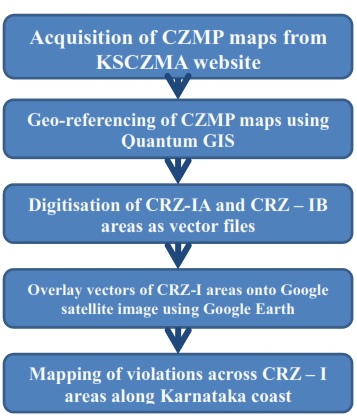
Figure 1. Method for mapping CRZ violations
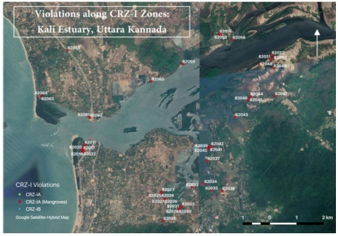
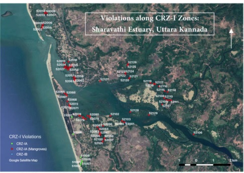
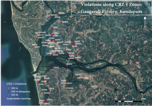
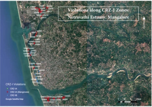
Figure 2: Violations of CRZ-I Zones in (a) Kali estuary (b) Sharavathi estuary (c) Gangavaliestuary (d) Netravathi estuary in Karnataka
Karnataka has a total of 11839.47 ha of the coast delineated as CRZ-I areas across the three coastal districts, i.e., Dakshina Kannada (982.03 ha), Udupi (3040.06 ha) and Uttara Kannada (11839.47 ha). Out of this, the mangroves occupy an area of 2298.94 ha (54%) without including the buffer area. Karwar taluk of Uttara Kannada has the largest area covered by mangroves (934.57 ha) with Bhatkal, Uttara Kannada having the least (13.88 ha) (Table 3).
| District |
Taluk |
CRZ-IB |
CRZ-IA |
CRZ-IA (Mangroves) |
CRZ-I (Taluk-wise) |
CRZ-I (District-wise) |
| Dakshina Kannada |
Mangalore |
702.41 |
279.62 |
155.04 |
982.03 |
982.03 |
| Udupi |
Udupi |
1426.59 |
323.19 |
141.55 |
1749.78 |
3040.06 |
| Kundapura |
796.71 |
493.57 |
261.48 |
1290.28 |
| Uttara Kannada |
Bhatkal |
379.30 |
86.22 |
13.88 |
465.52 |
7817.38 |
| Honavar |
642.82 |
639.75 |
151.66 |
1282.58 |
| Kumta |
2341.03 |
1011.39 |
566.50 |
3352.42 |
| Ankola |
578.93 |
140.54 |
74.27 |
719.4 |
| Karwar |
681.32 |
1316.06 |
934.57 |
1997.39 |
| Total |
7549.12 |
4290.35 |
2298.94 |
11839.47 |
11839.47 |
Table 3: Area covered by CRZ-I zones along Karnataka Coast (in ha)
| District |
Taluk |
CRZ-1A |
CRZ-1A(Mangroves) |
CRZ-1B |
CRZ-1B(TalukWise) |
CCRZ-1 (Districtwise) |
| (No) |
| Dakshina Kannada |
Mangalore |
2 |
146 |
12 |
160 |
160 |
| Udupi |
Udupi |
0 |
193 |
19 |
212 |
375 |
| Kundapura |
0 |
163 |
0 |
163 |
| Uttara Kannada |
Bhatkal |
5 |
5 |
21 |
31 |
288 |
| Honavar |
10 |
129 |
1 |
140 |
| Kumta |
4 |
44 |
4 |
52 |
| Ankola |
0 |
0 |
0 |
0 |
| Karwar |
0 |
65 |
0 |
65 |
| Total |
21 |
745 |
57 |
823 |
Table 4. CRZ-I violations along the coast of Karnataka (Count in no.)
| District |
Taluk |
CRZ-1A |
CRZ-1A(Mangroves) |
CRZ-1B |
CRZ-1B(TalukWise) |
CCRZ-1 (Districtwise) |
| Area (ha) |
| Dakshina Kannada |
Mangalore |
0.07 |
24.96 |
0.42 |
25.45 |
25.45 |
| Udupi |
Udupi |
0.00 |
4.66 |
0.87 |
5.52 |
13.41 |
| Kundapura |
0.00 |
7.88 |
0.00 |
7.88 |
| Uttara Kannada |
Bhatkal |
0.76 |
0.30 |
0.24 |
1.31 |
17.48 |
| Honavar |
3.03 |
2.56 |
0.02 |
5.60 |
| Kumta |
0.28 |
1.57 |
0.05 |
1.91 |
| Ankola |
0.00 |
0.00 |
0.00 |
0.00 |
| Karwar |
0.00 |
8.67 |
0.00 |
8.67 |
| Total |
4.14 |
50.59 |
1.61 |
56.34 |
Table 5. CRZ-I violations along the coast of Karnataka (Area in ha)
A total of 823 instances of violations (Table 4) with respect to the CRZ Notification 2011 were identified across the state covering an area of 56.34 ha (Error! Reference source not found. ). The district of Uttara Kannada was found to have the highest instances of violations (288) with the Honavar Taluk contributing the most (140) within the district. Of the 140 recorded violations, about 92% violations are with respect to the mangroves and their 50 meter buffer zone where applicable as per the CRZ 2011 provisions. The district of Dakshina Kannada (Mangalore taluk) was found to have the least instances of violation (160). However, with respect to the area over which the violations have occurred, the least was in Udupi (13.41 ha) with the highest being 25.45 ha, as identified in Dakshina Kannada (Mangalore taluk). Most of the violations were found to have happened at the 50 meter mangrove buffer areas with the mangroves facing serious degradation problem, as brought out in the Shailesh committee report as well. A significance number of these violations are residential in nature though there are a few violations owing to industrial set-ups and/or expansions over large areas. The district of Udupi, having Kundapura and Udupi taluks along the coast, is known for its extensive small scale industries. The district has violated the mangroves and their buffers the most with a total of 356 violations over a cumulative area of 12.54 ha. Mangroves along estuaries and generally at the banks of tidal-influenced water bodies are critically affected by the development along the banks materialised in the form of infrastructure required for small-scale boat docking and the conversion of land into aqua-culture ponds and agricultural fields among other anthropogenic threats. The depletion of mangroves along the coast and banks of tidal-influenced water bodies, almost always invites more violations in the name of development and in the process, make the areas more vulnerable to natural calamities including floods and sea-level rise. Extensive CRZ-IA violations can be observed closer to estuaries with high productivity values owing to the socio-economic implications highly productive ecosystems have on the local communities. CRZ-IB zones however are very few in numbers with most of the taluks having no violations. They are, however, very high (21) in the case of Bhatkal taluk of Uttara Kannada with four taluks across Karnataka having no violations at all. A list of all the violations marked across the Karnataka coast has been listed taluk-wise as Annexure 1.
|