| Sahyadri Conservation Series: 21 |
ENVIS Technical Report: 51, November 2012 |
 |
CONSERVATION RESERVE STATUS TO LATERITIC PLATEAUS OF COASTAL UTTARA KANNADA |
 |
Energy and Wetlands Research Group, Centre for Ecological Sciences, Indian Institute of Science, Bangalore – 560012, India.
*Corresponding author: cestvr@ces.iisc.ac.in
|
|
CASE FOR COASTAL LATERITE PLATEAUS AS ‘CONSERVATION RESERVES’
Conservation Reserves are declared for the purpose of protecting landscapes, seascapes, flora and fauna and their habitat. The rights of people living inside a Conservation Reserve are not affected. Conservation Reserves can be declared by the State Governments in any area owned by the Government. Particularly stressed are areas adjacent to National Parks and Sanctuaries and those areas which link one Protected Area with another. Such declaration should be made after having consultations with local communities.
Reasons for laterite Conservation Reserves: We are proposing here two lateritic plateaus of coastal Uttara Kannada viz. 1.Bhatkal plateau in Bhatkal taluk and 2. Mugali plateau in Honavar taluk under the conservation category called Conservation Reserves under the provisions created by the Ministry of Environment and Forests. Details of the two plateaus are as follows:
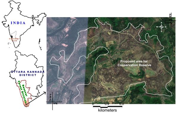
- Bhatkal laterite plateau: The plateau proposed for Conservation Reserve covers part of Bhatkal forest beat and part of Kotkhanda forest beat in the Bhatkal range of Honavar Forest Division. The proposed plateau covers about 425 ha of area within lat.13.99915° -14.02062° N and long. 74.55929°-74.59044°E (Figure 4). The detailed study of the flora was carried out and the plateau can be considered one of the richest lateritic floristic provinces of Uttara Kannada, and hence worth of its conservation for the sake of ecology, biodiversity and posterity.
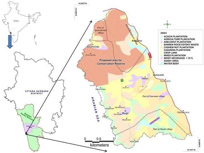
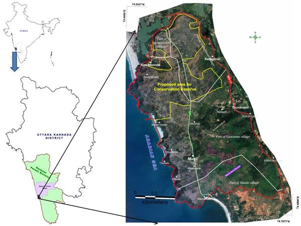
- Mugali laterite plateau: The plateau proposed is also in Honavar Forest Division. It covers area of about 300 ha in the coastal villages of Mugali, Kelaginoor and Apsarakonda villages. The proposed plateau is part of a much larger one and is situated between lat. 14.1977°-14.2437°N and long 74.4406°E-74.4806°E (Figure 5). The detailed floristic study was carried out and details presented in this report.
Both the proposed areas are, admittedly, not adjacent to National Parks and Sanctuaries, nor they link one PA with another. Yet they have very important reasons to be considered as such reserves for the following reasons:
- These Conservation Reserves are going to be, perhaps the first in the world, exclusively for lateritic ecosystems
- Laterite is a unique type of tropical sedimentary rock (basalt derived laterite of Maharashtra mountain tops excluded from its purview), and for the first time in the world described by Francis Buchanan during his journey through Kerala-Karnataka coast in 1801. He described it in Angadipuram in Malabar region where the Geological Survey of India erected a monument in laterite in his memory.
- Western Ghats constitute a global biodiversity hotspot, and several sites have been recently declared by UNESCO as World Heritage Sites. Unfortunately there has been never an effort to recognize the rare herbal vegetation of coastal laterite plateaus and hills, which have a good proportion of rare and endemic herbs.
- Rare animals like Pangolin and Monitor lizard can be conserved ideally in such reserves
- The laterite formations are aesthetically pleasing, and particularly so with the massive flowering of rainy season herbs. The terrain is ideal for tourism and scientific studies
- UNESCO Criterion 9 or declaration of a place as Heritage Site pertains to “outstanding examples representing major stages of earth's history, including the record of life, significant on-going geological processes in the development of landforms, or significant geomorphic or physiographic features”. The coastal laterite formation is a testimony to India’s separation from Madagascar almost 90 million years ago, and the erosion that happened through several million years of the primeval Western Ghats, and deposition of such eroded materials along the coastline, which originally belonged to the Tethys Sea, before the Arabian Sea came into existence.
- The seasonal herbs constitute the main foraging sources for honey bees and various other pollinators during the peak of rainy season, when there is absolute scarcity of any feed for them. Hence such plants may be considered as ‘keystone resources’.
- Moreover the declaration of Conservation Reserves is not going to affect the rights of the people living in the area. On the other hand community participation in management can earn revenue for them, especially from tourism
- The State Government can declare the Conservation Reserves.
Figure 4: Proposed Bhatkal laterite plateau Conservation Reserve
Figures 5: Proposed Mugali laterite Conservation Reserve map (up) and Google imagery
|
|
|
T.V. Ramachandra
Centre for Sustainable Technologies,
Centre for infrastructure, Sustainable Transportation and Urban Planning (CiSTUP),
Energy & Wetlands Research Group, Centre for Ecological Sciences, Indian Institute of Science, Bangalore – 560 012, INDIA.
E-mail : cestvr@ces.iisc.ac.in
Tel: 91-080-22933099/23600985,
Fax: 91-080-23601428/23600085
Web: http://ces.iisc.ac.in/energy
Subash Chandran M.DEnergy & Wetlands Research Group, Centre for Ecological Sciences, Indian Institute of Science, Bangalore – 560 012, INDIA.
E-mail:
mds@ces.iisc.ac.in
Joshi N.V.
Energy & Wetlands Research Group, Centre for Ecological Sciences, Indian Institute of Science, Bangalore – 560 012, INDIA.
E-mail:
nvjoshi@ces.iisc.ac.in
Rao G.R.
Energy & Wetlands Research Group, Centre for Ecological Sciences, Indian Institute of Science, Bangalore – 560 012, INDIA.
E-mail:
grrao@ces.iisc.ac.in
Prakash N. Mesta
Energy & Wetlands Research Group, Centre for Ecological Sciences, Indian Institute of Science, Bangalore – 560 012, INDIA.
E-mail:
prakash_honavar@ces.iisc.ac.in
Balachandran C.
Energy & Wetlands Research Group, Centre for Ecological Sciences, Indian Institute of Science, Bangalore – 560 012, INDIA.
E-mail:
bchandruji@gmail.com
Sumesh N. Dudani
Energy & Wetlands Research Group, Centre for Ecological Sciences, Indian Institute of Science, Bangalore – 560 012, INDIA.
E-mail:
sumesh@ces.iisc.ac.in
Citation: Subash Chandran M.D, Ramachandra. T.V, Joshi N.V., Rao G.R, Prakash N. Mesta, Balachandran C. and Sumesh N. Dudani, 2012. Conservation Reserve Status to Lateritic Plateaus of Coastal Uttara Kannada., Sahyadri Conservation Series 21, ENVIS Technical Report : 51, November 2012, Energy & Wetlands Research Group, Centre for Ecological Sciences, Indian Institute of Science, Bangalore 560 012.