VEGETATION
The forest is classified as evergreen, semi-evergreen and moist deciduous based on the percentage of evergreen trees present in the sampled localities. Table 2 details the vegetation classification.
Table 2. Vegetation classification
| Vegetation type |
Evergreen trees (%) |
| Evergreen |
90 to 100 |
| Semi-evergreen |
50 to 90 |
| Moist deciduous |
Less than 50 |
A preliminary examination or reconnaissance of the study area is required to get a general picture of the landscape and its vegetation. Regional and topographic maps and survey maps assist in determining access routes, topographic obstacles, study of onsite features, and for spatial analysis (GIS - Geographic Information System). The reconnaissance survey would provide:
- Major vegetation patterns and plants communities, including their growth forms and dominant species.
- Correlation between plant communities and features such as topography, geology, soil and water.
- Past and present human influence on the vegetation.
- Identification of unknown plants - the plant materials need to be collected for later determination.
- Herbarium is to be prepared in needy cases.
Dandeli wild life sanctuary has been used for timber (teak) production for quite a long period of time. The area is mostly dry deciduous forest with some intermittent patches of semi evergreen forest. The monocultures of teak are not advisable for the long term benefit of the forest. It becomes important to study spatial pattern of vegetation in the sanctuary for better management.
Data Collection
Primary data collection in representative sample plots has to be done based on both qualitative and quantitative assessments. The frequency and number of the species present in different quadrat samples assess species abundance and diversity. Secondary data collection, which includes the preparation of species list occurring in the study area, is to be done by site visits and by consulting published literature.
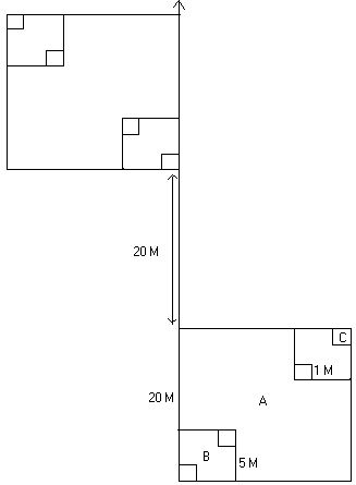
Sampling Methods: A transect based quadrat method is used for vegetation sampling. The transect length may range between 100 to 200 m depending on the terrain and vegetation. However, in extreme cases, as in small islands and very large homogenous patches, transect length can deviate from the general range. Quadrats of 20 X 20 m area are laid along transect, alternating on either side at intervals of 20 m, as shown in Figure 3.

Fig. 3: Schematic representation of transect based sampling method for vegetation study
The area of transects should be chosen without any bias to the terrain or the type of vegetation in the area. All the trees falling within the quadrates and having a girth of more than 30 cm (or 10 cm diameter) are to be recorded. The girth at breast height, height of the tree (ideally through clenometer) and the name of the plant are to be recorded (Table 3). It is difficult to identify all the plant species till species level based on the vegetation structure alone. Collect a small twig of unidentified plants for later identification.
Ground Vegetation Sampling:
Shrub Sampling: As can be seen in Figure 3, 5m X 5m opposite quadrates within the 20m X 20m tree quadrate are taken for shrub sampling. The ground layer of plants (>1m height and higher but GBH < 30cm) should be sampled. Tree sapling, shrubs as well as tall herbs are enumerated in these 25m2 sub samples.
Herb Sampling: As seen in the opposite corners of 1m X 1m in each of the 5m X 5m are taken for herb diversity studies. Plants less than 1m in height are included in this quadrat. The plants may include lower plants like pteriodphytes as well as tree seedling.
Measurement of Canopy Cover: Multi-layered canopy structure as in the tropical rain forests is greatly significant in stopping the force of the torrential seasonal rains, in preventing soil erosion as well as in inducing greater percolation of water into the soil. The ideal way to measure the canopy of the vegetation is through the densitometer but rough estimates can be given by visual estimates. Within each tree quadrat of 20m x 20m, the nature of canopy cover is observed at 5 points and ranked as 0, 1, 2 and 3 as shown in Figure 4. Mean value of the 5 points was taken as the canopy for respective quadrat.

Fig. 4. Visual Estimate of Canopy Cover
Regeneration status of tree species: The regeneration status of various tree species are calculated in the sampled localities based on the representation of any given species of tree in different girth classes. The tree species distributed in all girth classes are considered as having good regeneration, whereas the ones with representation only in the higher girth classes might indicate the prevalence of different ecological conditions in the past.
Data Sheet for vegetation sampling
Date: Time:
Lat. Long. Altitude:
Hamlet: Village: Beet: Range:
Name of the observer:
- Transect no. Quadrat no.
- Transect length.
Canopy Cover:
Table 3: Data Table
| Name of the plant |
Height |
GBH |
Phenology |
Climbers |
Remark |
Specimen number if collected. |
| |
|
|
|
|
|
|
| |
|
|
|
|
|
|
| |
|
|
|
|
|
|
| |
|
|
|
|
|
|
Any unusual sighting like epiphytes, parasites or unusual branching pattern will be recorded in remarks column.
Note: The following additional details are to be recorded from each sampled locality.
- Patch type: Evergreen, semi-evergreen, moist-deciduous, scrub, etc.
- Legal status.
- Nature of the terrain: steep slope/moderate/low to flat/undulating.
- The occurrence of a stream associated with the site.
- Rock outcrops or rockiness: high/moderate/poor to nil.
- Nature of rocks: lateritic/non-lateritic.
- Soil erosion on the site: high/moderate/least.
- Nearest human habitation (approximate distance).
- Notes on human interference viz., lopping, tree cutting, burning, fuel extraction, litter collection, cattle grazing and any other activities.
- Sacred value.
- Non-Timber Forest Produce (NTFP) collection.
Ecological Measurements:
A number of basic measurements are used in describing population and communities. Among these are density, frequency, coverage and biomass. Other important ecological measurements such as population distribution, species diversity and productivity are made from these.
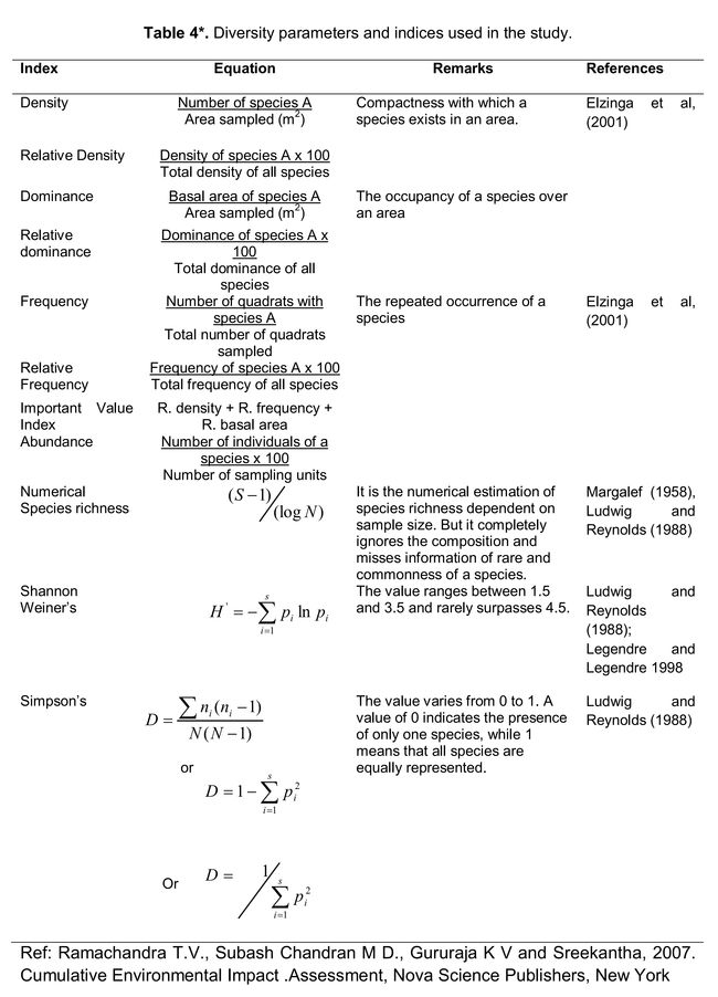
Diversity is an indicator of status of an ecosystem. It consists of two components, the variety and the relative abundance of species. The higher value indicates higher diversity. Diversity is estimated using the Shannon-Weiner and Simpson methods. Various indices that are used in the biodiversity studies, which include both flora and fauna, are listed in Table 4.
