
Introduction
Megacities in India are urbanising at an unprecedented and irreversible rate, as the global proportion of urban population has increased from 28.3% in 1950 to 50% in 2010 (World Bank, 2011). Urbanization is one of the demographic issues in the 21st century in India and efforts are required to understand the changes in the land and to ensure the sustainable use of natural resources (Jieli et al., 2010; Soffianian et al., 2010; Ramachandra et al., 2012a). Understanding the process of urbanisation would help the city planners to understand and plan and eradicate the problems associated with increased urban area and population, and ultimately build a sustainable city. Urbanisation is one of the few major topics that has been studied focusing on socio-economic, and environmental perspectives in urban areas (Cohen, 2006), to economic perspectives in peri–urban areas (Ravallion et al., 2007), to the loss of vegetation(Ramachandra et al., 2012b) and with respect to urban emissions (Banerjee and Srivastava, 2011, Ramachandra and Shwetmala, 2009, Fung et al., 2005). Qualitative attempts have also been made to summarize the development of urbanization studies (Morse, 1965). The urban process refers to the conversion of the rural and natural forms into urban areas due to population immigration into existing urban area. Rural–urban migration is one of the major events that usually accompany economic expansion and hence leads to major agglomerations. Increased density of population has direct impact on the social and economic condition of the cities (Knox, 2009). This phenomenon is particularly significant in developing countries, where the rural–urban areas become one of the very important places of urban growth. These peri-urban areas where the urban sprawl occurs are devoid of basic amenities and are normally left out on most of the civic governing body facilities(Ramachandra et al., 2012b). Urban sprawl is considered tobe one of the major reasons for rural push and spreading of city towards outskirts. The sprawl takes place at the urban fringes resulted in radial development of the urban areas or development along the highways results in the elongated development of urban forms (Sudhira et al., 2003). The urban sprawl quantifies the urban process and urban pattern. Urban Sprawl further affects the urban core areas by phenomena such as massive congestion, insufficient public transportation and infrastructure, lack of proper sanitation and many other basic amenities. With it come extreme socioeconomic disparities, vulnerability to natural and manmade risks (Fuchs et al., 1994; Mitchell, 1999;Kraas, 2007; Kraas and Nitschke, 2008;Ramachandra et al., 2012a). This necessitates the study of spatial urban growth patterns. Urban pattern refers to the spatial properties and configuration of the area at a particular time (Galster et al., 2001). Urban patterns also deals with physical structure and the spatial characteristics of the urban processes that vary over time (Aguilera et al., 2011).
Urbanization process in Delhi has the major impact on the India’s urban development. The rapid increase of urbanization resulted in the increased population density. Geo-informatics such as Geographic Information systems (GIS) with the temporal remote sensing data help to quantify changes in landscape structure that result from various disturbances (Turner and Carpenter, 1998; Punia and Singh, 2011).Earlier studies focused on measuring sprawl through the use of population and its dynamics (Eryilmaz et al., 2008; Ramachandra et al., 2012a). However this approach indicate the effect but don’t effectively quantify the pattern and the distribution of urbanisation. Shannon’s entropy reflects the concentration of dispersion of spatial variable in a specified area/zone was computed to account for the growth , (Sudhira et al., 2003, Sun et al., 2007; Sarvestani et al., 2011; Ramachandra et al., 2012a, Bharath H.A. et al., 2012), and to measure and extent of sprawl.Further attempts are made through spatial metrics to measure and understand the pattern of growth, whichalso aided in characterizing the landscape (e.g., O’Neill et al., 1988; McGarigal and Marks, 1995; Gustafson, 1998; Hargis et al., 1998; Jaeger, 2000; Zhao and Murayama. 2011; Ramachandra et al., 2012a, Ramachandra et al., 2012b).
Spatial metrics measure the units derived from the spatial data that aid in quantifying the landscape features (Herold et al., 2002, Ramachandra et al.,2012a). The metric based spatial analyses provide quantitative characterizations of the spatial and time composition of landscapes, which would be useful to analyse and understand the changes in landscape structure and patterns (Henebry and Goodin, 2002). The combination of remote sensing and spatial metrics helps to derive spatial information about urban growth, its structure and dynamics that helps in understanding of urban growth processes (Deng et al., 2009, Ramachandra et al., 2012b).
In this backdrop, the objectives of this communication i) understanding the urban dynamics through land cover and land use analysis, ii)understand the local level changes that takes place in the region using directional density gradients, iii)understand and quantify the growth and patterns through spatial metrics. This communication is divided into 4 parts. Part 1 gives details of the study area with its associated attributes. Part 2 discusses the methods adopted in the current research, third part deals with the results and discussion of the results. Final part draws the conclusion based on the analysis of the study area.
Study area: Delhi is one of the largest metropolis by area and second largest metropolis by population. It is the eighth largest metropolis in the world by population with more than 16.75 million inhabitants in the territory and with nearly 22.2 million residents in the national capital urban region.Delhi is located at 28.61° North latitude and 77.23° east longitude. It borders the Indian states of Uttar Pradesh to the east and Haryana on the north, west and south and is situated on the banks of the River Yamuna. The River Yamuna serves as the bed of agricultural land (Veronique Dupont, 2004). Delhi lies about 300m above the sea level. Delhi is also known for its heritage as the city or the region that was the capital of Pandavas during the times of Mahabharatha. It is jointly administered by both the federal Government of India and the local Government of Delhi. The annual mean temperature is 25 °C and has an extreme temperature ranging from -0.6 to 46.7 °C. Figure 1 depicts the Delhi administrative boundary(with circular boundary) and ten kilometer buffer considered. The buffer region is expected to reveal the sprawl trend which helps in visualizing the likely urban growth in the region. The National Capital Territory (NCT) of Delhi is spread over an area of 1,484 sq. km. and the Delhi metropolitan area lies within NCT. The NCT has three local municipal corporations: Municipal Corporation of Delhi (MCD), New Delhi Municipal Council (NDMC) and Delhi Cantonment Board (Mookherjeeand Eugene, 2004). The central Delhi is considered as central business district and consists of many industrial and residential areas and Delhi Fort and Jumma masjid are famous monuments found in Central Delhi. The Rastrapathi Bhavan, Parliament House and Supreme Court of India etc. are also located in New Delhi.
Figure 1: Location and spatial extent of Delhi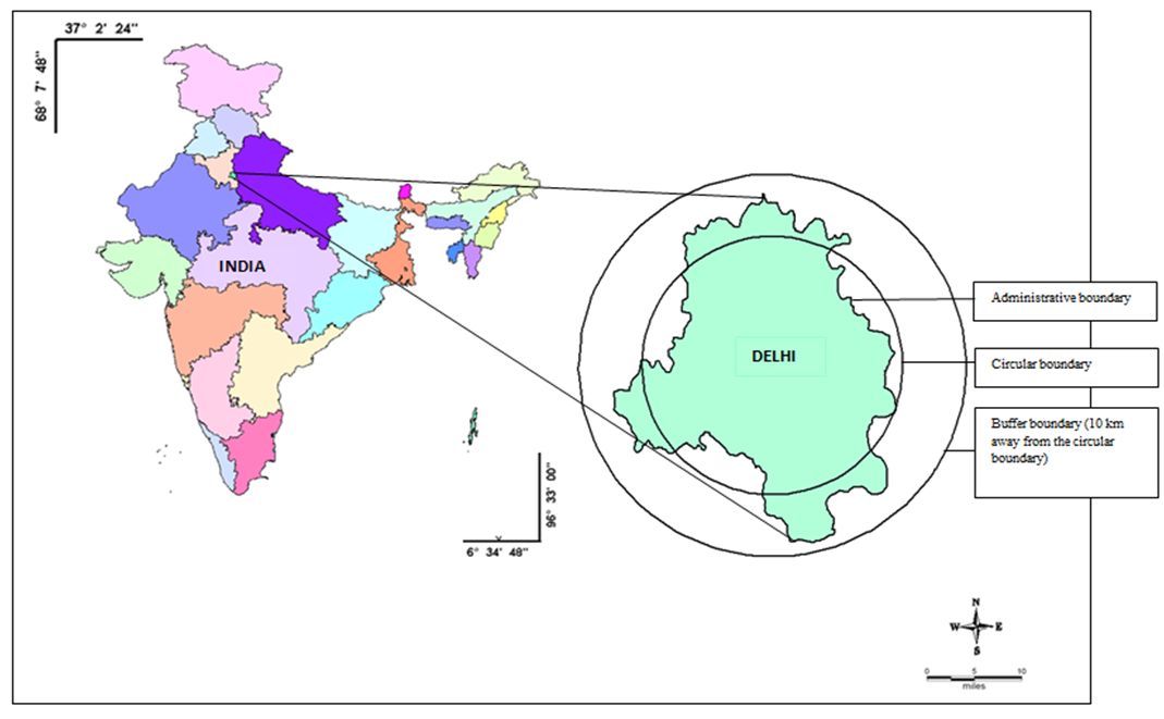
Figure 2: Populationdynamics in Delhi during 1901 to 2011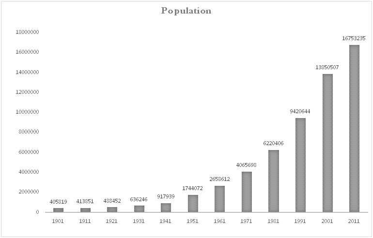
Figure 2 and table 1 portray the population growth of Delhi during 1901 to 2011. Table1 reveals that the population density has increased from 1207 (1970) to 5726 (in 2011) persons per sq.km. The FDI inflows to Delhi during the period 2000-2006 were found to be Rs.318.61 billion. The total FDI inflows into Delhi is about is US$ 20.1 billion according to Economic survey of India. The intensify growth of economy and higher per capita income within the urban district have influenced the real estate’s business resulting hike in the costs of land and cost of living.
Table1: Area, Population and Population density of Delhi
(Source: Census India-1971, 1981, 1991, 2001 and 2011).
| Area (sq.kms.) | Year | Population (lakhs) | Population Density (Persons per sq.km.) | |
| Delhi | 2926.03 | 1971 | 4065698 | 1207 |
| 1981 | 6220406 | 1899 | ||
| 1991 | 9420644 | 2804 | ||
| 2001 | 13850507 | 4371 | ||
| 2011 | 16753235 | 5726 |