New GRASS GIS tutorials
Participants of a GRASS GIS workshop contribute new tutorials
The workshop Geospatial data analysis with GRASS GIS organized by Gulich Institute in Argentina, concluded last week with participants from different Latin American countries defending their work. The workshop went through different topics within GRASS ecosystem, but mostly covered remote sensing, Object Based Image Analysis (OBIA) and time series analysis, making use of GRASS GIS extensions to obtain and process Landsat, Sentinel and MODIS data. All the workshop material including presentations, code, and data, is available here (in Spanish).
To pass the workshop and get their certificate, students were given two options:
- write a report in Spanish for which they should pick a topic of interest, find relevant data and use GRASS modules to obtain results or,
- write a tutorial in English of a topic relevant for them or even something new they wanted to learn.
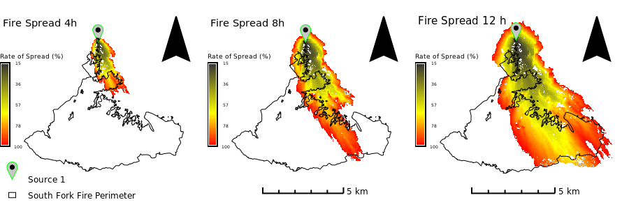
Topics chosen by the students were diverse and interesting: from changes in snow cover in southern Argentina, to productivity of high altitude grasslands, wildfire simulations, segmentation to aid digitalization of implanted forests, network analysis, comparison of classification approaches to map urban areas, landscape characterization, urban heat islands, spatial and temporal gap-filling and species identification through OBIA and machine learning. Students overcame installation difficulties, learnt and studied new modules, searched for data, explored different solutions. Some, even moved to Linux and learnt to use Git. It was really satisfying to see their learning process and outcome.
Here, I’d like to highlight two outstanding tutorials:
- Wildfire Modeling in Yosemite National Park by Abraham Coiman from Venezuela. In this tutorial, Abraham combines the use of GEE, geemap, GeoPandas and GRASS GIS within a Jupyter notebook to simulate wildfire spread in Yosemite National Park.
- Segmentation and species classification using hyperspectral data by Carol Garzon from Colombia. In this tutorial, Carol demonstrates the use of GRASS GIS OBIA toolset for species identification over the paramo using UAV hyperspectral data.

Congratulations all and welcome to the GRASS GIS community!