NAME
r.topidx - Creates a topographic index (wetness index) raster map from an elevation raster map.KEYWORDS
raster, hydrology, wetness, topographic indexSYNOPSIS
Flags:
- --overwrite
- Allow output files to overwrite existing files
- --help
- Print usage summary
- --verbose
- Verbose module output
- --quiet
- Quiet module output
- --ui
- Force launching GUI dialog
Parameters:
- input=name [required]
- Name of input elevation raster map
- output=name [required]
- Name for output topographic index raster map
Table of contents
DESCRIPTION
r.topidx creates topographic index (wetness index), ln(a/tan(beta)), map from elevation mapwhere
- a: the area of the hillslope per unit contour length that drains through any point,
- tan(beta): the local surface topographic slope (delta vertical) / (delta horizontal).
Input maps may have NULL values. For example, if you have a MASK for a watershed (basin map from r.water.outlet), the following command will create a masked elevation map (belev):
r.mapcalc "belev = if(isnull(basin), basin, elev)"
r.stats -Anc prints out averaged statistics for topographic index.
EXAMPLE
Running the command below will generate the topographic index map shown in the figure:g.region raster=elevation -p r.topidx input=elevation output=topidx_elevation
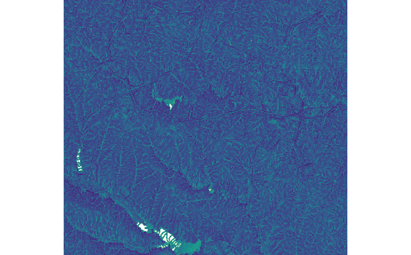
Figure: topographic index map derived from elevation map
REFERENCES
Cho, H., 2000. GIS Hydrological Modeling System by Using Programming Interface of GRASS. Master's Thesis, Department of Civil Engineering, Kyungpook National University, Korea.Moore, I.D., R.B. Grayson, and A.R. Ladson, 1991. Digital Terrain Modeling: A Review of Hydrological, Geomorphological, and Biological Applications. Hydrological Processes 5:3-30.
SEE ALSO
r.topmodel, r.water.outlet, r.mapcalcKnown issues
AUTHORS
Huidae ChoHydro Laboratory, Kyungpook National University, South Korea
Based on GRIDATB.FOR by Keith Beven.
SOURCE CODE
Available at: r.topidx source code (history)
Latest change: Thursday Feb 03 11:10:06 2022 in commit: 547ff44e6aecfb4c9cbf6a4717fc14e521bec0be
Main index | Raster index | Topics index | Keywords index | Graphical index | Full index
© 2003-2023 GRASS Development Team, GRASS GIS 8.2.2dev Reference Manual