NAME
g.gui.mapswipe - Interactively compares two maps by swiping a visibility bar.KEYWORDS
general, GUI, displaySYNOPSIS
g.gui.mapswipe
g.gui.mapswipe --helpg.gui.mapswipe [first=name] [second=name] [mode=string] [--help] [--verbose] [--quiet] [--ui]
Flags:
- --help
- Print usage summary
- --verbose
- Verbose module output
- --quiet
- Quiet module output
- --ui
- Force launching GUI dialog
Parameters:
- first=name
- First (top/right) raster map
- second=name
- Second (bottom/left) raster map
- mode=string
- View mode
- Options: swipe, mirror
- Default: swipe
- swipe: swiping the upper map layer to show the map layer below
- mirror: synchronized maps side by side
Table of contents
DESCRIPTION
The Map Swipe is a wxGUI component which allows the user to interactively compare two raster maps of the same area by revealing different parts of the raster maps. It is useful e.g. for comparing raster maps from different time periods. Map Swipe can be launched from the menu File -> Map Swipe.Map Swipe allows you to:
- switch orientation of the swipe line (horizontal or vertical)
- zooming, panning
- automatically load maps when opening Map Swipe with two selected raster maps in Layer Manager
- compare 2 raster maps or load different combinations of raster and vector maps and set transparency (advanced mode)
- save display to graphics file
- display text labels with map names
- choose between 'swipe' mode (default) and 'mirror' mode (synchronized maps displayed side by side)
- change the appearance of cursor in 'mirror' mode (available in Map Swipe settings)
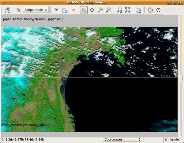
Pre and post disaster images of the tsunami in Japan in 2011. The upper MODIS image taken on February 26, 2011, shows the coastline under normal conditions while the lower MODIS image on March 13, 2011, shows a clear view of tsunami flooding along the coastline. Water, black and dark blue in these false-color images, still covers the ground as much as five kilometers (three miles) from the coast. Source: Earth Observatory/NASA
SEE ALSO
wxGUIwxGUI components
See also the user wiki page.
AUTHOR
Anna Kratochvilova, Czech Technical University in Prague, Czech RepublicSOURCE CODE
Available at: wxGUI Map Swipe source code (history)
Latest change: Saturday Jul 16 18:18:43 2022 in commit: 63e79c72f61149092b9546da4bc343cc581aa180
Main index | GUI index | Topics index | Keywords index | Graphical index | Full index
© 2003-2023 GRASS Development Team, GRASS GIS 8.2.2dev Reference Manual