Our imaginary flight finally nears the Pacific Coastal and Interior Mountains. We proceed across the Sierra Nevadas, the large, strongly glaciated tilt block of crust composed mostly of igneous and metamorphic rocks associated with numerous interpenetrating batholiths. This mountain range rises precipitously to 4,421 m (14,494 ft) at Mt Whitney - the highest point in the 48 states - on its east side (south of this scene). The east side tends to be steep-fronted, being fault-bounded, whereas the western slopes are gentler in inclination, although still deeply dissected by streams. The scene below shows off the northern Sierras with Reno at top center, volcanics in the westernmost Basin and Range appearing in bluish tones, Lake Tahoe nestled in the High Sierras, and many deep valleys. Dark firs and other vegetation persist up to about 2750 m (9000 ft), above which trees are absent and rock bare (light tan).
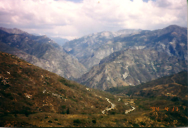
In the high country, glaciation has carved out deep canyons and rugged landscapes. This ground view of the Kings Canyon National Park area to the south is typical.
We then pass west over
rolling ground in the Sierra Foothills across the Central Valley into the Coast
Ranges around the San Francisco Bay area, all shown in this October, 1972 Landsat
image.
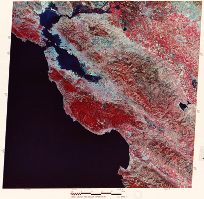
Most of the landmarks we describe next, we can see in this high-altitude aerial oblique image taken by a camera onboard a NASA U-2 aircraft. The view from this perspective looks east-northeast from a point over the Pacific Ocean. In the distance are the snow-capped Sierra Nevadas and the Sacramento Valley. Try to match specific features in this IR photo (which, incidentally, is blue-dominated because the sky blue effect was not compensated by a haze filter) with their counterparts in the Landsat image.
The Central Valley, known in its northern half as the Sacramento Valley (the southern half is the San Joaquin Valley), is one of the great agricultural regions of the world. The numerous farms visible in the above imagery attest to this dominant land use. Cash crops include beans, cotton, rice, barley, and sugar beets. Stockton and Modesto are the two large valley towns.
The Coast Ranges are the most recent products of still active orogeny that results from the collision of the Pacific and North American lithospheric plates. The mountains consist of granular (clastic) sediments in places metamorphosed by high temperatures and pressures or intruded by igneous magmas. Their rocks have been severely deformed, but the ranges generally rise only a few thousand feet above the Pacific sea level. Passing near the coast but inland is the great wrench (horizontal movement) fracture known as the San Andreas Fault (look for the abrupt termination of red [from California oaks, redwoods, and other vegetation] in the mountains south of San Franciso), which is the plane dividing the north-moving Pacific side of the fault from the more static North American side.
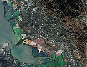
Two coastal bays stand out in this image: Monterey Bay near the bottom (noted for its rich aquatic and bird life) and San Francisco Bay, which to its north becomes San Pablo Bay, along which San Francisco (west), Oakland (east), San Jose (south) and many other Bay Area towns are situated. The fault-bounded hills to the east are part of the Diablo Range, which becomes progressively less vegetated towards the Great Valley (at this time of year it is covered with the same brown, dried grasses we examined in the Morro Bay subscene).
Most of San Francisco appears
in grayish-blue tones that indicate a sparsity of trees in the city (rather surprising
to any resident or visitor who is struck by its great beauty). The exceptions
are the lush vegetation (many eucalyptus trees) in Golden Gate Park (long rectangle)
and the Presidio (a now deactivated military facility). Your monitor resolution
may allow you also to pick out a tine (blue) line of ships (mothballed Liberty
Ships and others from World War II) right of the narrow Carquinez Straits off
the east end of San Pablo Bay.
In the southern part of
the Bay are large patches with lighter blue or green tints. These are salt evaporating
basins. The greenish ones are actually basins with red sediments (bright tones
in Thematic Mapper band 3 that thus pass green light in a transparency). A closer
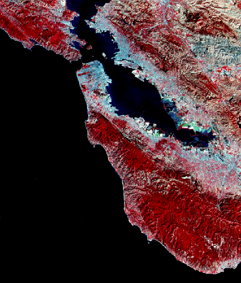
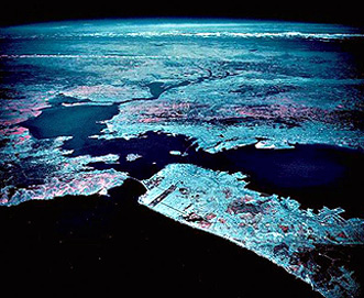
look at these basins is afforded by the MISR sensor onboard the Terra spacecraft;
compare this with the second image below:
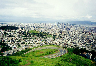
Many, including this writer,
consider San Francisco the most beautiful city in the U.S. Here is a photo taken
in 1994 by the writer that shows the central city from the tourist vista called
Twin Peaks. Lets take a closer look
from space by enlarging the Bay Area portion of the full Landsat image. 6-12:
In the above subscene, find Berkeley, Oakland,Hayward; San
Jose; the San Francisco Airport, Palo Alto, and Mount Diablo (near to which
the writer lived for 2 glorious years). ANSWER We carry this enlargement
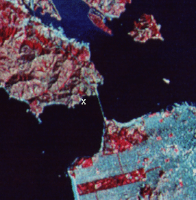
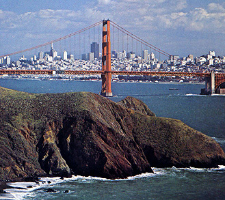
even further to highlight the most famous bridge leading into the Peninsula
from the north, the Golden Gate Bridge. The view of "the City" through
the bridge (lower image) is from the vantage of a small park on the Marin County
side (at X in upper image). The Presidio and Golden Gate Park are also obvious.
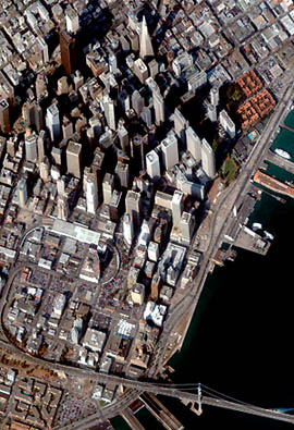
A most remarkable image
of downtown San Francisco with its many tall building (some visible in the above
photo) has been taken by the commercial IKONOS satellite (SpaceImaging, Inc.).
This color version has a spatial resolution of 2 meters:
Before taking leave of
the City by the Bay and central California, we present one more interesting
Landsat image. It shows the Bay area clear of fog (normally in summer fog rolls
in every day) but the Great Valley to the east is entirely fog shrouded. This
is the so-called tule fog that often develops inland under the right meteorological
conditions. Note that this fog has spilled over the low pass where Highway 50
crosses the eastern Coast Range into the Livermore Valley to the west.
Whoa! Some viewers of this
Tutorial who live in the Pacific Northwest may feel slighted in that we haven't
shown any imagery so far that covers their fast-growing region. We can ameliorate
this seeming oversight by allowing our airplane to change course in Nevada and
head northwest into Oregon. The view below is a mosaic (production of this type
of composite scene is treated in the next section) of images covering most of
the western halves of Oregon and Washington:
The large river that divides
the mosaic is the Columbia which is also the state border between Oregon and Washington.
The near vertical set of white patches marks snow found on the higher elevations
of the Cascades. The large patch in the Oregon Cascades is Mount Hood. North of
the river are Mount Rainier and Mount St. Helens, among the numerous active and
dormant, variably eroded, stratovolcanoes that make up the High Cascades. In northwest
Washington is an E-W body of water off the Pacific Ocean that ends to the east
with various islands and several inlets including the N-S Puget Sound along which
Seattle is located. Near the upper left is the Canadian island of Vancouver. From
the Cascades westward the land is heavily wooded (including abundant firs and
evergreens), as indicated by the widespread reds. East of the Cascades, the land
is sparsely covered by trees - a consequence of the rapid reduction in rainfall
as clouds pass over the Cascades, dumping their moisture, and producing a so-called
"rainshadow" that creates a semi-desert ecosystem.
One Landsat scene in southern
Oregon (just below the bottom of the mosaic) contains several features of special
interest both within and east of the Cascades. Look:
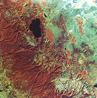
The focal point in this
scene is the circular lake known as Crater Lake. This 12 km wide (8 miles) lake
lies within a volcano, known as Mt. Mazama, that collapsed and erupted violently
about 10000 years ago, perhaps before humans lived in the region. Thick ash
beds resulted - much more than expelled from Mt. St. Helens. Klamath Lake lies near
the bottom. The blue lake to the east is Summer Lake. The Great Sandy Desert
(dark blue) is a series of volcanic flows that are roughly coeval with the Snake
River Plains to the east. When the writer first saw
this image, he was struck by the conspicuous large elliptical feature northeast
of Crater Lake. It resembled a huge volcanic caldera. Visiting it in 1966 during
a field conference, the western part known as the Walker Rim was a cliff composed
of volcanic flows. Solid evidence for a caldera was not obvious. This
may be a coincidental artifact of several topographic features that because
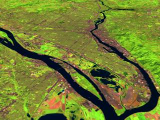
of vegetation distribution gives the impression of ellipticity. Portland, Oregon lies within
the land between the confluence of the Willamette River and the Columbia River.
Here this is seen in this Landsat-5 (RGB = 542) image taken on March 6, 1992
With these scenes, we end
our transcontinental sojourn. If you have crossed the states before, you can
use this tour as a reminder of what you saw. If such a trip is in your future,
this tour is a splendid preview of what you could look for. Bon voyage!
But wait! You should
really be aiming to become a world traveler. For the U.S., there already is an
Atlas of Landsat scenes covering the 48 contiguous states. Would be nice to have
a World Atlas composed of Landsat images (except, since up to 11000 are needed
to cover all land areas, such an atlas would have more pages the a multi-book
Encyclopedia; we recommend using only images for areas where you expect to spend
a lot of time). To affirm that you have now the skills needed to "geographically
locate" a Landsat image, we are going to give you another (littler) test. On the
next page are 8 full and four partial Landsat scenes, taken from all (except the
Antarctic) of the other continents besides North America. They are labeled from
A to H. Using any means at your disposal (but a World Atlas is best) try to locate
each scene. To help you in this, we will put a few key word hints beneath each
image.
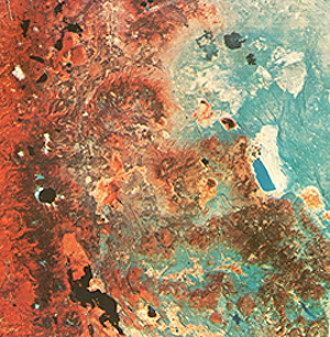
As a further aid to this recognition
test, we will present an unidentified image on this page, give you a chance to
locate/identify it, and then at the top of the (next) quiz page, the writer will
walk you through the process by which he was able to determine the identity of
this scene. All we will say at this point is that this is a MISR image (Section
16) and that it is deliberately oriented such that North is not at the top, as
an added challenge.
So, to proceed with the
game, press "next". This
will get you in the proper frame of mind to then pass onto the second part of
this Section, which is the travelogue through the continents that helps you,
through looking at various characteristic cities and landscapes, to gain a perspective
on the wide varieties of scenery that make up the land surfaces of planet Earth.