|
The
Nevada Basin and Range; The Desert Southwest; and The Snake River Plains
|
A large region of the west from southeastern Oregon and part of Idaho, through nearly all of Nevada, western Utah into most of southern Arizona and eastern California is known as the Basin and Range province. This province, dominated by uplifted blocks of sedimentary and igneous-metamorphic rocks set between broad, flat valleys swings eastward through New Mexico into West Texas, and continues southward into Mexico. Typical examples of the varied landscapes are shown on this page.
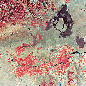
The Colorado Plateau ends in western Utah. Almost the entire state of Nevada
falls within the Basin and Range province. This Landsat image mosaic shows much
of that province in most of Nevada but Death Valley, the southern Sierra Nevada
block, and a bit of the Great Valley (San Joaquin) near Bakersfield, are in
California.
Major C.E. Dutton, an early
explorer of the American West, described these mountains as they appeared on a
map as resembling "an army of caterpillars crawling northward out of Mexico".
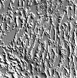
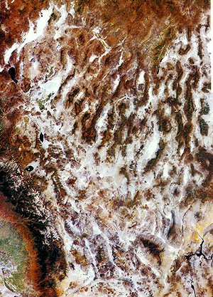
That is re-enforced by the next image, a shaded topographic depiction of the region
made from DEM data (method described on page 11-5; another example
is on page 7-2). This
rendition emphasizes the notable flatness of the valley floors in the basins.
The ranges can be quite distinctive,
standing out between valleys as bare rock, since many are almost devoid of arboreal
vegetation. This scene is in Nevada:
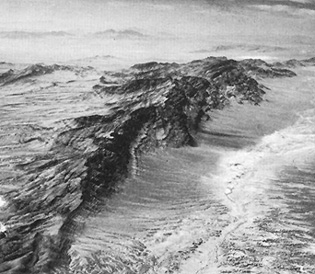
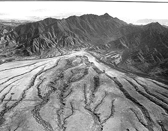
Another range occurs north
of Tucson, AZ and is capped by a pine forest. At the foot of the Santa Catalina
Mountains, shown below, is a thick, deeply gullied alluvial fan.
Such characteristic topography
results from a complex structural history dominated by block faulting (somewhat
like the faulting we described in Kenya on page 3-2). The region,
as it underwent tensional stresses during uplift of the crust, responded by
fracturing. The fractures trend mostly north-south, along which segments dropped
down (faulted), leaving adjacent range blocks higher. The present elevations
can be greater than 2,700 m (8,900 ft), producing relief of 900 to 1,520 m (3000
to 5000 ft) relative to the basins. Among the major ranges in this scene are
the Shoshone, Toyabe, Toquima, Monitor, and Hot Creek Mountains; higher slopes
are forested, as suggested by the reds in this September scene.
The intermontane basins between
ranges are back-filled with great amounts of rock debris descending downslope,
so that the valley floors move upwards as the ranges wear down. The central (lowest)
surfaces of some of the basins contain playas (deposits of fine sediment left
after intermittent lakes evaporate following the rainy season) that are light-toned
in the image. Between playas and ranges, along the transitional zone known as
a piedmont (literally, "foot of the mountain"), are deposits of coarser sediment
(up to cobbles and boulders in size), mixed with clays that make up alluvial fans
(dark gray in the image).
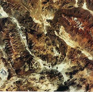
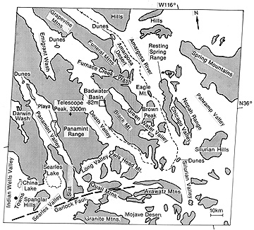
One of the classic areas
within the Basin and Range, near its southwest margin, contains Death Valley
and other block fault ranges. We show it below (locate it within the above mosaic)
along with a map indicating the names of the principal topographic features.
Below the Death Valley
area, the Basin and Range ends against the Mojave Desert. That region is located
within the structural salient north of the southern California Transverse Ranges
(see page 7-2).. Small
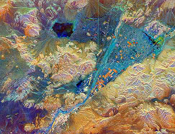
ranges within the Mojave closely resemble the barren block fault mountains of
the Basin and Range types. Here is a color radar image of an area near Barstow,
California, made from SIR-C C- and X-band imagery (see page 8-7). Note the alluvial
fan (in blue).
The Basin and Range type
of geology is widespread over western North America. From Oregon-Idaho through
Nevada and Utah, it spreads east into southern Arizona and New Mexico into northern
Mexico itself. One area of classic ranges and valleys is around Phoenix, with
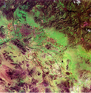
Las Vegas the fastest growing cities in the southwest U.S. The next image was
an experiment done in the early days of Landsat-1 to use MSS Band 7 (IR) to
render vegetation green. The fertile (irrigated from reservoir lakes) land in
the Salt River Valley within which Phoenix was built shows up as actively growing
in this February, 1973 image:
Around and south of Phoenix
the mountain ranges are small and isolated. North are the high, forested Mazatzal
Mountains - a much larger block that includes also the Sierra Ancha and Pinal
Mts. In the latter, note a pinkish red patch, which marks mine waste from the
Globe-Miami-Superior copper mining district. In these mountains is the dammed
Roosevelt Lake: it is a wonder on weekends to find 1000s of power boats being
hauled from Phoenix to cruise those waters. By now, you have gained
experience with picking out features in the landscape at the medium scales presented
in Landsat imagery. Before finishing our trip, we challenge you to apply your
experience by locating or identifying geographic and geologic landmarks in a
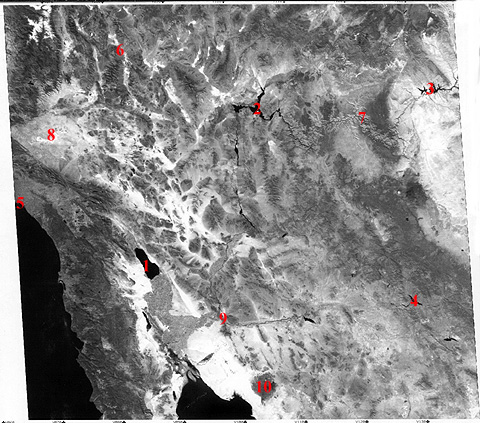
space image somewhat to the south of our main flight line. This image is much
smaller in scale, covering about 1,100 km (684 miles) on a side. Make this a
game of finding the places listed below. Look over the black and white Day-Vis
HCMM image that shows most of the southwestern U.S. (part of southern California
and Nevada, most of Arizona, a bit of Utah, and small segments of the Mexican
states of Baja California and Sonora), including some of the Basin and Range.
6-11:
Use a U.S or World Atlas to aid in correlating landmarks in the scene with mapped
features. To help you get oriented, the red numbers 1, 2, and 3 are the Salton
Sea, Lake Mead, and Lake Powell, respectively. Pin these down on an atlas to
give you a feel for the scale. Then, relying on the maps, identify what is at
or around the numbers 4 through 10. (The answers are below). Finally, without
the aid of number guides, try to find the Gulf of California, San Diego, the
Imperial Valley, the Sierra Nevada range, Las Vegas, Phoenix, and Tucson. Also,
what is the name of the great geologic fault that marks (as a straight tonal
boundary) the southern edge of the Mojave Valley? ANSWER The northern end of the
Basin and Range abuts against the Snake River Plains in Idaho, seen here in
this Landsat-1 full scene:
The Idaho Rocky Mountains
are seen near the top. The Plains themselves are a series of bluish-gray lava
flows (mostly basalt) that began some 10 million years ago. More recent is the
large Crater of the Moon National Monument - the conspicuous black blotch. Water
from the Snake River is used to irrigate the farms that produce Idaho potatoes,
sugar beets, barley, wheat. In 1963, when the writer
(NMS) was working in the AEC's Plowshare program (at Livermore, CA) for engineering
uses of nuclear explosives, he was given the responsibility of finding a site
in the plains basalts for Project Schooner. The most promising area was Bruneau
Canyon just west of the left edge of this image. After more than a month on
site, and several expensive drill holes, he recommended abandoning this once
promising area (the county where the detonation would have taken place has 25000
cows and less than 5000 people - logistically favorable) when unexpected lake
beds were found buried by younger flows near the surface.