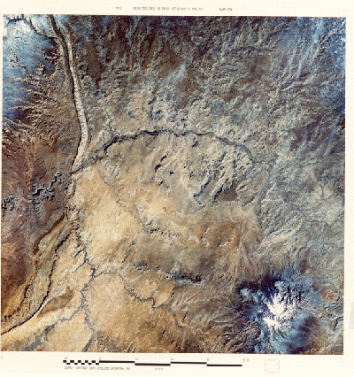
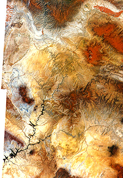
After about 500 km (311 mi) travel westward, our trip swings to the southwest as it moves over the Colorado Plateau. The Plateau includes a small part of western Colorado and northwestern New Mexico, much of northern Arizona and a substantial part of Utah. A good part of the Plateau is seen in this mosaic of several Landsat images:
Many people consider this the most scenic
of all provinces in the U.S. because of its marvelous landforms and its colorful
rocks. Many of its mainly Upper Paleozoic and Mesozoic rock units are bright reds,
oranges, and yellows, whereas others are light to dark gray to brown. To the southwest
of this scene, the Grand Canyon; the most famous feature in the Plateau; exposes
typical, multi-colored units. Bryce, Zion, and Canyonlands National Parks also
display spectacular colored rocks.
In Section 2, page 2-3, you have already
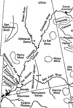
examined one small area in the Plateau, the Waterpocket Fold. To help you visualize
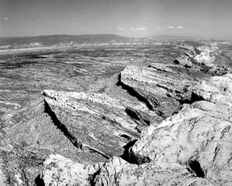
the landscape of this vast region, we show two ground scenes of characteristic
features, first, the San Rafael Swell (see map), a broad dome, and second, the
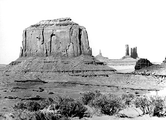
buttes that are so conspicuous in
Monument Valley, almost a trademark
for that part of the country and site of many western ("cowboy") movies, is
a landscape dominated by buttes (prominences composed of flat rock stacks that
are the remnants of stripping away of most of the higher layers from an earlier
plateau cover).
We will concentrate now on just one
Landsat image that includes parts of the lower right of the mosaic. The scene
shown here includes the Four Corners - the only place in the U.S. in which that
many states touch each other at one point.
Unfortunately, we can’t discretely identify the point, but it lies about
30% up and 15% in from the lower right corner of the image). This false color image, taken in
January, approximates some of these colors. At this time of year the sparse
vegetative cover of sage, mesquite, and grasses does not produce a typical red
signature, so that the surface tones are entirely those of rock and soil. The Plateau rocks are almost everywhere
still in the subhorizontal positions, in which they were deposited as sediments.
Because they erode along steep faces or scarps, where cap rock is hard, the
layers stack like steps to form plateaus, mesas, and buttes. The Gothic Mesas,
just to the right of image center, are typical. Monument Valley begins near
the lower left corner. The Plateau has participated in the general deformation
of the West chiefly by uplifting without folding. However, Combs Ridge, a prominent
monocline (like the Waterpocket Fold) is evident about 15-20% in from the left
edge of the image. Near the bottom right corner are the snow-capped Carrizo
Mountains, partially volcanic in origin, which rises at Pastora Peak to 2,870
meters (9,414 ft). These highlands blend into the Chuska Mountains to the south,
just out of view..
This barren region has a very low population.
Part of the scene includes the Navajo Indian Reservation. The small towns of Mexican
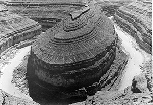
Hat and Bluff in Utah lie along the San Juan River. At center left, this river
has entrenched (deeply downcut) its meanders to produce steep canyon walls that
make up the picturesque Goosenecks, shown in this photo.
Just to the west of the image, the
San Juan River joins the Colorado River, upstream from the artificial Lake Powell,
formed by the Glen Canyon Dam. Finally, there is a "streakiness" in much of
the lower part of the image. Prevailing winds, re-enforced by joint (fractures)
control of landscape erosion, cause this effect. 6-10: What causes "goosenecks"? ANSWER