The largest expanse of land in the world that is a single political unit is Siberia, the huge tract that makes up most of Russia. Siberia is sparsely populated relative to European Russia, owing mainly to its harsh winter climate. It is, however, one of the richer sections of the Earth’s crust in mineral wealth and timber. Three types of landscape/ecosystem are predominant: the lowlands steppes, the subarctic tundra, and vast stretches of mountains. Because of its size, we will show two examples.
The first scene shows the westward flowing stretch of the Ob River, in the western Siberian Lowlands, about 500 km (300 miles) east of the Urals; as it moves further west it will turn north into the Kara Sea above the Arctic Circle. Its overall length is more than 4000 km (2500 miles). This meandering river now is in flood (June) after spring snow melt. The myriad of lakes in the upper half are formed as sinks owing to poor drainage in the underlying glacial tills. The entire region lies within the taiga forest zone, consisting of Siberian fir, stone pine, larch, and spruce. Surgut is the only town of any size in the image.
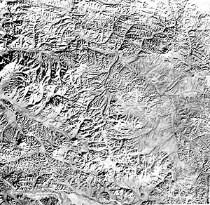
In the far eastern reaches of Siberia, mountainous terrain predominates. Here are mountain-like hills and divides on a rolling plateau surface etched by past glaciation and current stream erosion; these extend from the Chersogo Mtns just to the south. Already, by this October 28th, 1972 date, the entire region is snow covered. The main drainage path is the Indigirka River (lower left), into which flow the Ulakhan (mid-left) and Nera (upper left) rivers. Only a large village, Oymyakon on the Indigirka, is show on the regional map.
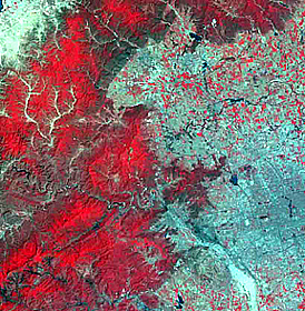
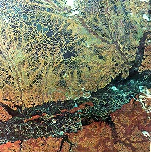
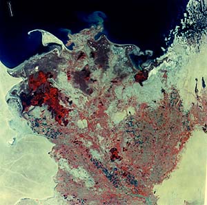
The image below is part of the Kyzul Kum desert region of Uzbekistan, one of the Muslim countries loosely tied to Russia. The region is north of Afghanistan, in southwest Asia. The major river, running up through the center of the image, is the Amu Dar’ya, the longest (2300 km; 1440 miles) in this part of Asia, and is noted for carrying the heaviest sediment load (derived from the Tian Shan mountains) of any major river in the world. This load is carried into the Aral Sea (top) which actually is a large lake, slowly evaporating so that its maximum depth now is about 25 m (80 ft). The river has built a very large delta on which cane thickets and woody brushlands are widespread. Marshlands are indicated by the deep reds. Some farming occurs on the delta but is isolated owing to frequent flooding and is most prevalent where irrigation ditches have been dug. The swarm of sandy "islands" in the upper right are dunes now dissected and submerged by locally rising waters.
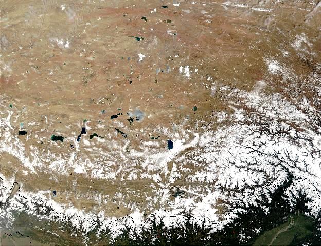
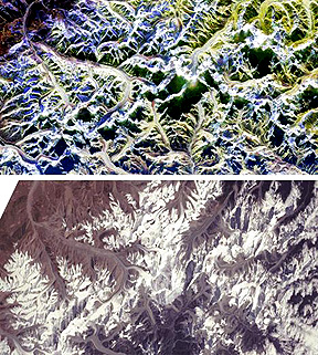
This next scene includes literally
"The Top of the World". The Himalaya Mountains, highest on Earth, and the highest
flatlands on our planet making up the Tibetan Plateau to the north. This Terra
MISR image shows much of both topographic features:
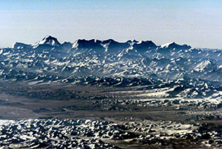
The grandeur of these mountains
has been captured in this photo taken looking south from the International Space
Station from a height of 120 miles. The seventh tallest mountain in the Himalayas,
Dhauchagriri, lies second from the left in this stretch; the Tibet Plateau is
in the middle ground.
The Himalayas occupy nearly
all of the country of Nepal (a bit of India is present at the bottom of the
next image). Its capital, Katmandu, is visible in the valley above the left
center edge. Going northward from the bottom, one passes across the High Plains
of the Ganges to a line of dissected gravel deposits, known as the Siwalik Hills
(elevations up to 1300 m [4300 ft], carried down from the high mountains during
active uplifts in the later Tertiary. Their deeper red color indicate subtropical
forests of bamboo and other vegetation. The relief becomes strikingly rugged
in the Lesser Himalayas (3000 m [10000 ft]), that continue to rise towards the
crest region of the High Himalayas (6000-8800 m [20000 to 29000 ft) marked by
snow cover in this December image. Mt. Everest (8848 m [29028 ft]) does not
stand out from neighboring peaks; it is near the upper right corner. Surprisingly,
snow is largely absent from the intermediate heights, owing to the drying out
of monsoonal rain clouds that have crossed the Indian subcontinent. This is a good time to
introduce an odd-shaped image, made by the Large Format Camera (LFC) flown on
one of the Space Shuttle missions (the camera and mission will be reviewed in
more detail on page 12-4). What you
see below includes the area in the above Landsat scene (find it) but also goes
much farther west and north.
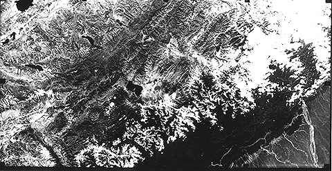
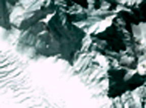
When one thinks of the
Himalayas, often the name "Mount Everest" flashes through the mind. This tallest
(28030 ft) peak on Earth is the ultimate goal of intrepid mountain climbers.
The best reason for trying this daring feat was given by Mallory's famous (and
profoundly simple) dictum: "Because it is there". More than 1000 have since
scaled it following the first successful try by Sir Edmund Hillary and his scherpa.
Here are two views: the top a SIR-C radar image that brings out the rugged topography;
the bottom a Landsat view:
Recently, the IKONOS multispectral
sensor made a notable image at 4 meter resolution that includes Mount Everest.
It is the triangular-shaped feature in the upper right; with this pattern, go
back to the previous figure to locate the peak.
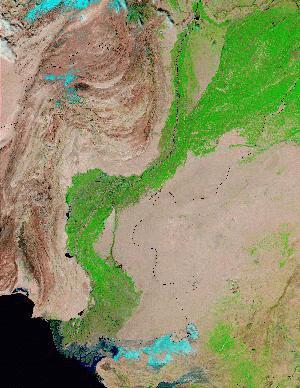
Before entering India again,
lets first look at much of Pakistan and western India as imaged by Terra's MODIS.
The fertile valley of the Indus River is bright green. Note the mountain structures
of Pakistan to the west which we will see again in a mosaic in Section 7.
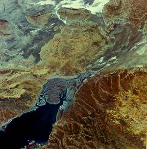
The Gulf of Kutch (lower
left) in western India (State of Gujarat) is surrounded by the Kutch lowlands
on the north and the Kathiawar Peninsula on the south. The region is also known
as the Rann of Kutch. Vast tidal and saline marshes, with little vegetation,
are distributed both in the upper left (the Great Rann) and at the head of the
Gulf. (the Little Rann). These mudflats are superposed on alluvial plains, possibly
developed when the Indus River to west once emptied further east into the Indian
Ocean. The dark brown areas on land are low rises capped by part of the Deccan
basalt flows that extend over much of western India. Only the area in the lower
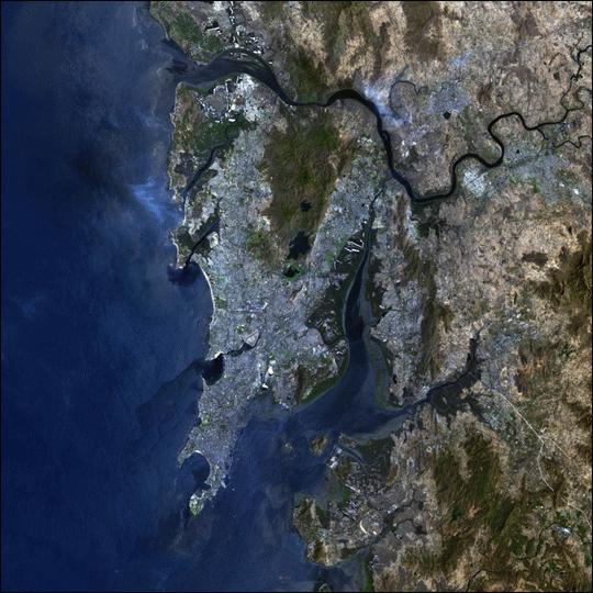
right is notably populated. South of the Rann, on India's
west coast, is one of its famed cities - Bombay (now renamed Mumbai, to detach
it from its English colonial history). Here it is in a Landsat-7 ETM+ image.
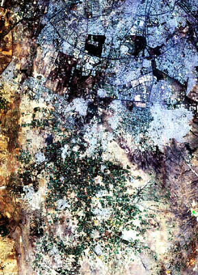
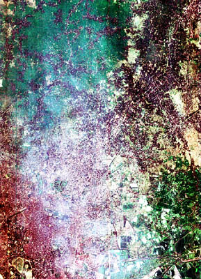
Moving north, then east
we see two PROBA images of India's capital, New Dehli, and then its most crowded
city, Calcutta.
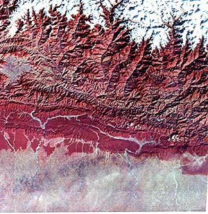
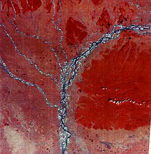
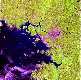
The Brahmaputra River northeast
of Calcutta, noted for its huge load of sediments, begins where several feeder
rivers from the mountains of Tibet and the easternmost State of India, Assam
meet. The river flows through Assam (right half of image) past the Shillong
Plateau and the Garo Hills (a Precambrian crystalline complex) and upper Bangladesh
(left), and finally into the Lower Ganges at Dacca (below this scene). In this
view, it is joined by several rivers from the foothills of Sikkim and Bhutan.
The Brahmaputra during rainy season can be greater than 8 km (5 miles) wide.
Here, more than a month after the end of the monsoons, most of the water has
flowed on, leaving choked stream beds and numerous small channels, a condition
known as a braided stream. Images of Bangkok, Hong
Kong, Beijing, Tokyo and several other parts of Asia appear elsewhere in the
Tutorial. Here we show two more cities. One is now a discrete nation: Singapore.
Below is an astronaut photo of part of the island on which the city of Singapore
is located:
Further east lies the Korean
Peninsula northwest of Japan. Here is a satellite image that shows the capital
of South Korea (pinkish-red) inland from the port of Inchon (site of MacArthur's
bold amphibious landing during the Korean War).
This ASTER image shows
a part of Seoul on the right:
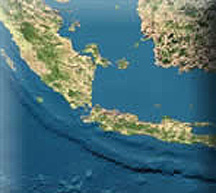
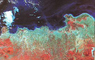
The confederation of thousands
of islands makes up the nation of Indonesia. This metsat view shows most of
Sumatra, Java, and part of Borneo. The majority of the islands are an "island
arc" - a series of uplifts in the ocean on the continental plate side of a tectonic
zone undergoing subduction (here, to the south) the lower part of which remains
submerged by the ocean.
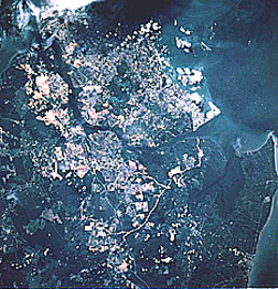
Jarkata is the capital
of Indonesia. It lies against the ocean near the northwest corner of the Island
of Java. Here is a Landsat-2 view:
The city is the uniformly
blue area next to the sea about 1/3rd left of the right margin. The prominent
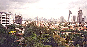
volcano at the left (west) edge is Merat. Jakarta is a sprawling modern city,
as evident in this ground photo.
The most extraordinary
single meal ever consumed by the writer (NMS) was at the Hotel Indonesia during
his mission for the U.S. State Department in 1974. It was a super Javanese "smorgasbord"
spread over a 60 foot long line of tables with dozens of tasty entree's. A 20
piece Gamelin orchestra, and 12 dancing girls provided entertainment. The entire
cost, including drinks, was $10 U.S. Unforgettable!