|
Geological
Setting at White Mountain, Utah
|
The test case to exemplify the value of remote sensing in picking out diagnostic alteration is an area in southwest Utah, known as White Mountain, studied by the writer (NMS) during his research days at NASA. Both iron and clay minerals are conspicuous at the site owing to decomposition of minralized volcanic rocks (the minerals are of insufficient nature and concentration to be viably minable). The area was overflown by the 24-channel Bendix multispectral scanner and numerous Landsat TM images also cover it. With the aid of a published geologic map and ground photos, the alteration and other lithologies at White Mountain are described.
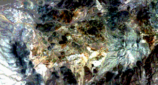
We now investigate a superb illustration of this last situation. Here is a Landsat Thematic Mapper (TM) subscene of an area in southwestern Utah:
The subscene, about 35 km (22 mi) on a side, resides within Beaver Co., Utah. It is about 24 km (15 mi) west of the small town of Milford and 64 km (40 mi) north of Cedar City, gateway to Zion National Park to its south. The physiographic setting places this area well within the Basin and Range Province, which, geologically, is a series of generally north-south trending mountain blocks that are upfaulted between downdropped valleys or basins. The area lies within the High Desert country of the U.S. Southwest. On the left side of the image is a part of the Wah Wah Range, a typical block-fault mountain system. To the right are a group of isolated hills composed of eroded volcanic flows and small outliers, such as White Mountain (gray roundish landform near the image center), of Paleozoic sedimentary rocks. Lowlands within the scene extend into basins filled with eroded debris from the uplands, including alluvial wash (such as the bright-toned area in left center) that form sloping aprons. Distinguish this terrain from the clouds and their shadows. Just to the left of White Mountain is an elongated (east-west) area, about 8 km (5 mi) long, characterized in this false color version (Bands 2,3,4) by blotchy orange-brown to tan tones. These colors are a classic expression of gossan staining associated with a mineralized zone.
5-3: Make sure you find this mineralized area with its distinctive staining; is there evidence for similar gossan elsewhere in the image? ANSWER
Here, we show a part of
this area in a natural color aerial photo (somewhat overly red-brown in its
printing) obtained during the NASA Aircraft Mission 340 flown for the writer
(NMS) in 1976 (see page
2-3 for details).
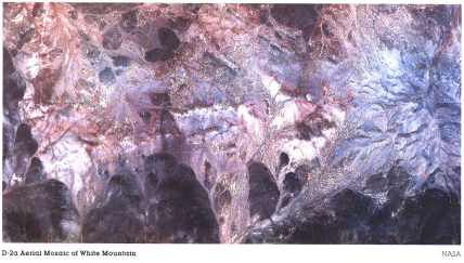
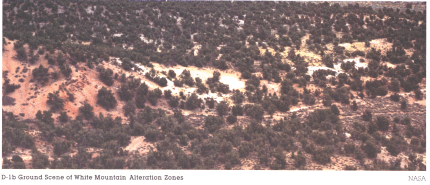
In a ground photo, we see
the same area consists of gentle rolling terrain covered sporadically by cedar
and sagebrush.
In the satellite image,
this vegetation does not stand out as blotches of red, suggesting that cedar
has a weak reflectance response in the near-IR. 5-4:
How many different colors, that may relate to the alteration,
can you discern in this ground photo? ANSWER A published geologic
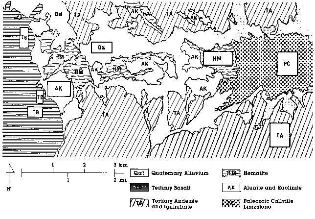
map (Stringham and Brooke, 1962) of this area indicates a wide variety of
alteration types have developed here. Their report states that mineralization
consists of pyrite and chalcopyrite (copper-bearing). The latter is not of
sufficient grade (amounts) for mining. A group of volcanic rocks called andesites
show the most alteration. After they flowed into this region and cooled, volcanic
gases and hot solutions modified some of them. One alteration type is kaolinite,
a common clay mineral used in ceramics. It is light brownish-white at this
location. A second, light-gray mineral is alunite, a hydrous potassium aluminum
sulphate. The principal alteration mineral is hematite, the anhydrous iron
oxide, which is medium grayish-red. Minor amounts of limonite are present,
but the yellow-brown color of the space image corresponds mainly to altered
hematite rather than the similar gossan. Very white areas of siliceous sinter
are scattered about and a few areas contain natural sulphur, which comes from
the breakdown of the original sulphides. In the ground-based photograph above,
the light patch coincides with mainly a kaolinite-alunite (k/a) mix, and the
reddish area is hematitic staining on weathered volcanics. To appreciate their
general distribution in this subscene, examine the map below, a simplified
version of the published map, which didn't reproduce well on this Web Page.
This map can be printed for ease of reference in studying the images below.
We now consider a set of
Landsat images we processed to illustrate how to apply remote sensing data effectively
in mineral exploration. Suppose, to start, that we are modern prospectors, searching
for some metal (gold is the obvious choice, but copper is often the more likely
find). If we had chosen a large region in which to hunt, we would be grateful
for Landsat imagery that encompasses many thousands of square miles. Even in
a full scene, the anomalous color in the White Mountain area (as this alteration
district is known) would grab our attention because it is typical of a gossan
signature. Our first logical step would be to zoom in on our image processor
to the immediate area showing this signature in a natural color (TM Bands 1-3)
rendition.
Dark areas in the subscene
relate mainly to the volcanics. On the left side, the map shows that these are
basalts (an almost blackish rock, typical of Hawaiian volcanoes and of the Snake
River volcanic plains of Idaho). Those dark areas at the top and bottom are
somewhat lighter (but still dark grayish-brown) andesites, which are typical
of volcanoes in the western U.S., such as Mt. St. Helens. White Mountain stands
out on the right in light bluish-gray tones. It contains a radial pattern that
corresponds to furrowed gullies draining down from its central peak. The main
alteration zones make up a pattern with an east-west branch that meets a north-south
segment on the left. Most of this alteration is displayed in the yellow-browns
seen in the regional subscene. Other zones are much lighter (sort of tan) in
this image. These two principal zonal types broadly match the hematite and k/a
areas on the generalized map shown above. Areas on that map that we identified
as alluvium (soil and loose surface debris) show up in several variant colors
in the subscene. Those with a color similar to the hematite are alluvial deposits,
derived from the altered hematitic zones. An equivalent subscene made from Bands
2,3,4 (not reproduced here) contains very little discrete red patches, confirming
the sparsity of active, reflectant vegetation. 5-5:
Granted that it is troublesome to scroll up and down on
this page, we still think it worth your time to compare the units in the geologic
map with their approximate counterparts in the aerial photo at page top and
the Landsat subscene near the bottom. You may conclude that the match isn't
perfect. Why might this be so? ANSWER