|
The
U.S. Capital: Washington, D.C.; Baltimore, MD; Philadelphia, PA
|
Most U.S. citizens and
many foreigners eventually visit Washington, D.C. to take in the wonders and
sights of the Nation’s Capital. This page takes one on just such a tour
using a combination of ground scenes, aerial photography, and space images.
You will be asked to identify a number of the famed monuments and federal buildings,
using an atlas if necessary. You will also visit its neighbor city, Baltimore.
The U.S. Capital: Washington,
D.C.; Baltimore, MD; Philadelphia, PA
4-9:
This general question, or activity, applies to this whole
page. Each of the images represents a higher resolution version of the preceding
image, generally with a different sensor/satellite system. Try to fit each successive
one to its predecessor. Locate the landmarks and features that are described
in the text. Your biggest challenge will be to relate features in the radar
image to the others. ANSWER
We now move to the eastern
seaboard to focus on the southern part of the great metropolitan corridor that
runs from Boston, through New York and Philadelphia, and past Baltimore and Washington,
D.C. ending in Richmond, VA.
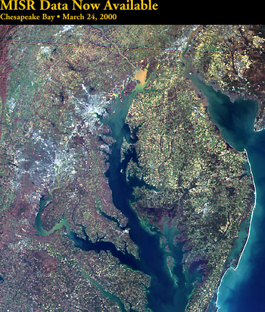
Let's start with a very
recent image (Spring, 2000) of parts of Maryland, Virginia, and New Jersey,
and all of Delaware, as imaged by MISR, one of the instruments onboard Terra
(see page 16-9). Most of the
Chesapeake Bay and all of the Delmarva Peninsula appear. Washington and Baltimore
in this rendition are whitish. At the head of Chesapeake Bay, the orange-brown
patch denotes sediment carried into the Bay from the Susquehanna River.
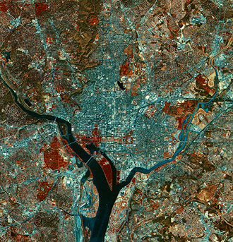
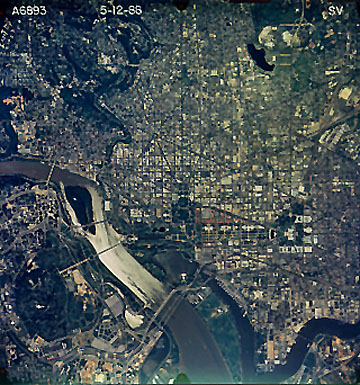
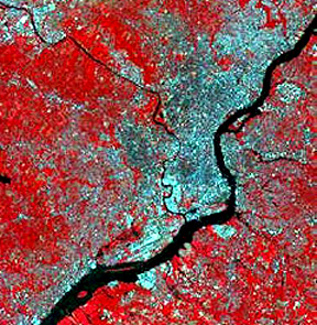
We next show those two
cities below in a famous subscene (about 113 km [70 mi] across) that was taken
from the October 11, 1972 pass of Landsat-1 on a remarkable viewing day in which
the air was crystal clear after a major storm passed.
The effects of that storm
are evidenced by the light blue tones in the Potomac River, resulting from a
heavy silt load dumped by runoff from the rainfall upstream. The increase in
sediment does not affect the Chesapeake Bay to the east, of course, the inner
city areas of Baltimore and Washington are by the blue tones that signify numerous
large buildings and a limited number of trees. More than five million people
live in this urban region but much of the population dwells in residential areas
in which tree-dotted landscapes remain (recent surveys identified the Washington
area, in particular, as the most heavily forested urban locale in the eastern
U.S.). A large blotch of deep red (abundance of trees) in the northeast part
of the Washington suburbs represents the largely undeveloped tract of land comprising
the Beltsville Agricultural Experiment Station, which the U.S. Department of
Agriculture operates. Interstate 95 between Washington and Baltimore - the heaviest
traveled major road in the East - stands out in contrast to its vegetated edges.
We can also see Highway 50 past Annapolis, the capital of Maryland,and, the
high Bay Bridge over the Chesapeake narrows is just visible.
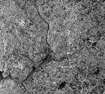
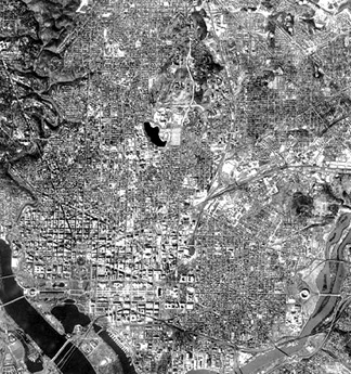
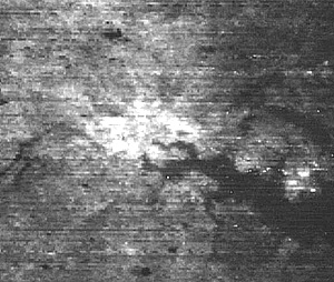
We use a SIR-C L-band radar
image, which was obtained on April 18, 1994, from the Space Shuttle to look
closer at the metropolitan area surrounding the U.S. capital.
In this image, north is
to the upper right. No distinct tonal patterns marking the more densely populated
and built-up sections of the area are evident, but many of the major roads leading
in and out appear as thin dark lines. Two dark patches coincide with the National
Airport (just below the center) and Andrews Air Force base (lower right). Farmlands
(diminishing as outlying areas develop) make up many of the other darker patterns.
We find most of these farms to the east in the Coastal Plains.
The Coastal Plains' precise
juncture (at the Fall Line) with the hilly Piedmont (see map on page 6-1 and accompanying
text) to the west is obscure but the rolling terrain on the left side of the
image infers where the Piedmont begins. A remarkable feature of this image is
the three light-toned lines forming part of a square. These lines coincide with
the boundary between the District of Columbia and Maryland. Staff at the Jet
Propulsion Laboratory (SIR-C's operators) interpreted this tonal phenomenon
as expressing strong reflections from building corners that line avenues along
the boundaries. But, this writer, who lived in the area for 21 years, is skeptical
of the explanation, because there is no unusual concentration of large buildings
lining the streets along the boundaries. Along the NE-SW edge many building
are residences no different than other homes away from the boundary streets.
The line next to the boundary running NW-SE (right side of square) that continues
beyond the District is a power line.
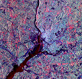
Some of these features
stand out better when the several radar bands on SIR-C are combined to make
this color composite:
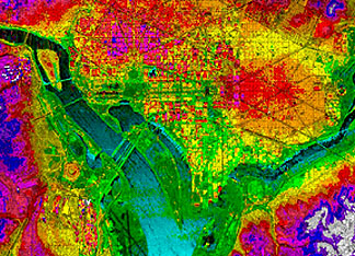
This radar image of part
of D.C. was made by an aircraft system operated by JPL as part of its interferometry
program to make topographic maps (see page 11-10). The IFSAR
system uses two radar images, taken moments apart, that are thus staggered spatially
to get a "stereo" effect. In this image, the colors represent variations in
elevation, which, although generally less than 30 meters (100 ft) in relief,
can still be determined by the radar interferometric method:
The next two images, made
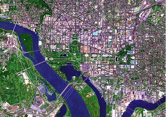
by SPOT sensors, present much more detail in the central metropolitan area around
the District of Columbia. The false color version at the top (about 24 km [15
mi] on a side) is made by the HRV multispectral sensor that provides 20 meter
resolution. On the bottom is a 10 meter panchromatic image that extends about
13 km (8 mi) on a side, showing the central city and its many federal buildings.
The HRV image nearly encompasses
the Capitol Beltway which rings the Washington area but does not stand out here.
Several vegetated areas are worth identifying: the wooded area known as Rock
Creek Park; Roosevelt Island in the Potomac; the Arlington National Cemetery;
and the National Arboretum. The circular Robert F. Kennedy (RFK) stadium is
easily identified. (Check an atlas to locate these features.) The panchromatic
SPOT image shows the layout of buildings around the Mall and the downtown business
area, as well as, homes (many are joined row houses) in the District. Consult
a map to confirm the location of most of the well-known individual edifices.
Use major streets such as Independence, Constitution, Pennsylvania, New York,
and Massachusetts Avenues, and the Interstate 395 extension, so help locate
sites.
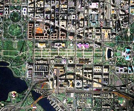
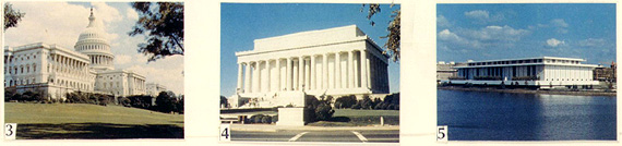
The centerpoint in this
and the next two images is the Mall that runs from the Lincoln Memorial (4)
eastward to the U.S. Capitol (3) (Note: The spelling "Capitol" is used
to specify the building and immediate surroundings and the hill [Capitol Hill]
on which they are located to avoid possible confusion with other federal aspects
of the nation's capital.). These two structures (see pictures below), along
with the Kennedy Center for the Performing Arts (5), are examples of the graceful
white marble edifices that house many of the government offices, monuments,
and cultural centers, in what many believe is one of the most beautiful capital
cities in the world.
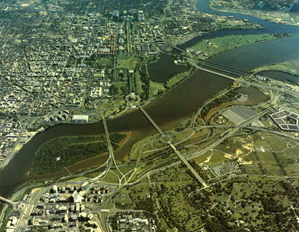
This aerial oblique color
photograph, which was taken from the Virginia side of the Potomac affords a
"birds-eye" view of this central area.
Viewers who have visited
the capital city should recognize many of the landmarks. On the lower right
is the Pentagon, and part of the National Cemetery is in the foreground. Beyond
Roosevelt Island is the Kennedy Center. Nearby are the Lincoln Memorial and,
on the Tidal Basin, the Jefferson Memorial. The White House is hidden by trees
but the Ellipse (a near-circular drive and parkland) is just to its south. The
Washington Monument is too thin to be seen clearly in this photo. But, many
government office buildings lining the mall are evident.
Because Washington, D.C.
is the home base of NASA and it is often hailed as the "Capital of the Free
World (or Democracy)", it is a favorite target for imaging by nearly all the
Earth-observing satellites currently flying. Although the writer (NMS), from
his hands-on experience, has long been partial to Landsat, he now freely admits
that Terra (Section 16) is at present the most versatile spacecraft of this
genre in the sky. Here is a Terra ASTER 15 m resolution image of Washington
that, even though not the equal in detail of those shown below, is, together
with imagery from Terra's other sensors, evidence of that versatility:
The image below, displayed
in near full screen size, is a merge of a 5 m IRS panchromatic image with a
30 m natural color Landsat subscene. This visually attractive rendition covers
much of the Virginia side of the Federal District, including the Arlington National
Cemetery and the Pentagon.
Compare what you can see in
this high resolution color aerial photograph below with the scene just above.
This should persuade you that space "cameras" are now competitive with those flown
on airplanes. For reference, the U.S. Capitol Building and its grounds lie near
right center in both scenes (above and below).
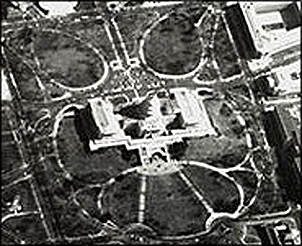
The military surveillance
satellite KH7 (see page
2-26e) took this 7 meter image of the U.S. Capitol building and grounds
in the summer of 1965.
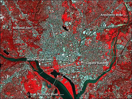
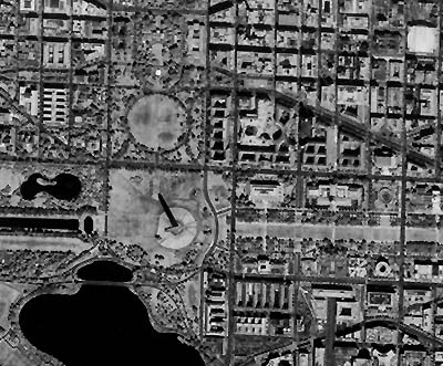
Now to an identification
challenge in this next image of Washington, D.C. It was constructed by merging
a Landsat TM subscene rendered in the IHS (Intensity; Hue; Saturation) color
system and a 2-meter (6.6 feet) resolution space photo made by cosmonauts using
the Kosmos KVR-1000 camera onboard the Russian Mir space station.
Use a map to locate the
following: Washington Monument; Jefferson Memorial; U.S. Capitol Building; Union
Station; National Air and Space Museum; Hirschorn Gallery; National Gallery
of Art; National Museum of Natural History; Smithsonian Administration Building;
Federal Bureau of Investigation (FBI); The White House; U.S. Dept. of State;
and the U.S. Dept. of the Treasury. However, don't look for the NASA building
if you have an older map, because its headquarters has moved and most atlases
don't show this new location.
4-10:
There is something (a structure) in this image (related
to the Kosmos part) that can give you the approximate time of day when Kosmos
was passing over. Can you figure this out and estimate the hour. What important
monument is out of the picture? ANSWER
Before we leave the U.S.
Capital section of Washington, let's look once again at the marvelous IKONOS-2
image showing the left half of the same area as in the above MIR KVR-1000 image.
This was first introduced in the Overview to appraise you of the very significant
development in applied remote sensing in which high resolution imagery (here,
about 2 meters also) has come into the marketplace with the decision by the
Russians to "go commercial", followed by the launching of several satellites
operated by private companies. In that Overview is also the 1 meter IKONOS panchromatic
black and white image of buildings and a bit of the Mall just west of the Capitol
Building.
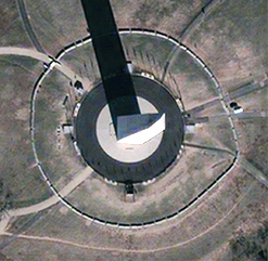
In January, 2002, an even
higher resolution (<1 meter) image of the Washington Monument was provided
among the first scenes released by the QuickBird satellite launched in later 2001:
You were informed that, in
the Landsat scene, the blue area near the top of the Landsat image is the city
of Baltimore, Maryland. Since the writer (NMS) lived outside that town for 11
years and has many fond memories of the good life it offered (including winning
seasons by the Baltimore Orioles), I would be remiss not to show several images
that capture its "flavor". The top one is a standard false color image made by
the Landsat-7 ETM+. This shows most of Baltimore's central city, and its western,
eastern, and southern suburbs (the northern part is not present). Conspicuous
is the large inlet coming off Chesapeake Bay to the east, as rising post-glacial
waters invaded the Patapsco Valley.
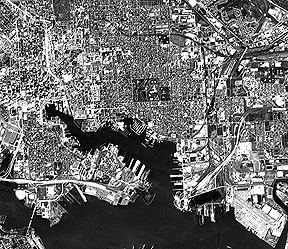
Second is a JERS-1 image
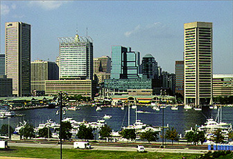
of the downtown, with its wonderful Inner Harbor development. Below that is
a color photo looking at the skyline. Unlike Washington, which has a restriction
on the height of buildings to keep a balance in proportion, Baltimore, like
most big U.S. cities, has an imposing set of tall buildings, as seen in the
ground photo that shows much of the Inner Harbor.
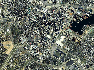
The next image was made
by the IKONOS satellite. It is among several used in the movie "The Sum of All
Fears", adapted from the book by Tom Clancy. In the book, the football field
in Denver was the one blown up by a terrorist nuclear bomb. For the movie, the
scene was shifted to Baltimore where Jack Ryan's wife worked as a medical doctor.
In each image, details of the Inner Harbor stand out; the Camden Yard stadium,
whom of the Baltimore Orioles, appears near the bottom, along with part of the
("blown-up") stadium used by the Baltimore Ravens football team.
Urban areas are normally
warmer by several degrees or more relative to the suburbs and countryside. This
is often referred to as the "heat island" effect. This Landsat-2 image of Baltimore
shows a much warmer area (lighter tones) in the central city around the Inner
Harbor:
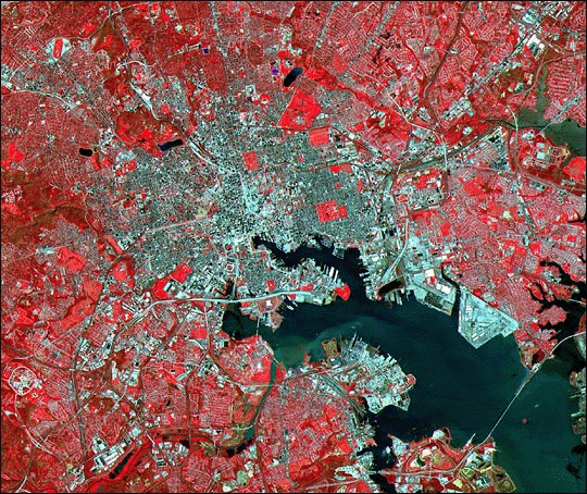
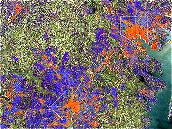
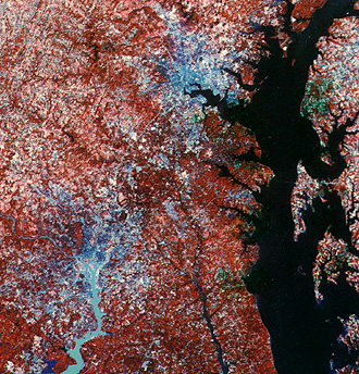
A Landsat subscene that
includes both Washington and Baltimore has been processed by a special algorithm
to classify ground cover to determine the degree to which the surface acts as
impervious (the term refers to ability of water to penetrate into the substrate)
to rainfall (this is important in specifying how much water enters the ground
and estimating the water that remains to cause possible flooding). Red is highly
impermeable, i.e., strongly impervious; blue is moderate and green is low impervious.
Reds associate with inner city dominance of buildings and roads; blues are typical
of suburbs; and greens generally associate with forests and fields.
Finally, largely to assuage
the writer's in-laws, who live outside Philadelphia, here is a Landsat image
of that city:
The size of the city's
environs is misleading, if one goes only by the blue areas. Most of the red
areas are actually populated suburbs, which are noted for their preservation
of natural and planted trees.
During colonial days, Philadelphia
was the largest city in North America (more than 30000 citizens). For part of
the Revolutionary War, it was occupied by the British under General Howe but
later was evacuated by their Army.
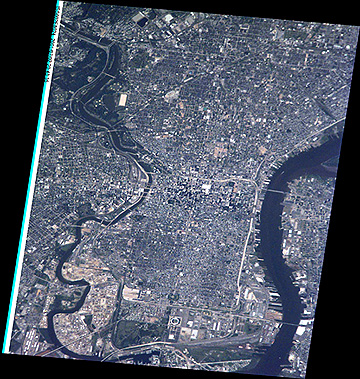
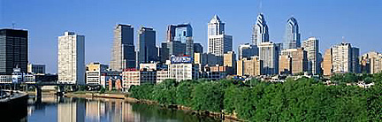
Today, Philadelphia is
still among the largest cities in the U.S. This photograph was taken of the
central city by astronauts onboard the International Space Station.
As one drives along the
Schuylkill Expressway, next to the river of that name, the skyline of Philadelphia
makes a strong impression: