|
Recognition
of Faults and Joints
|
Another regional scale feature usually easy to recognize in suitable space imagery is that of faulting. A fault is a fracture in the Earth’s crust along which there has been some relative movement of rock on one side against the other side. This appears as some form of displacement or offset of once contiguous units. Joints are fractures that do not involve differential movement; they are usually too small in size to be directly recognizable from space but their effect on topography may reveal their presence. Two examples are shown.
Faults are fractures along which there is relative sliding movement of the blocks in opposite directions on either side. We recognize them by various criteria:
1) Layers of different types and ages of rock units sit side-by-side
2) Abrupt topographic discontinuities of landforms
3) Depressions along the fault trace (broken rock is more easily eroded)
4) Scarps or cliffs
5) Sudden shifts of drainage courses.
6) Abrupt changes in vegetation patterns
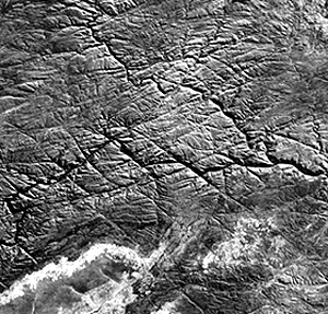
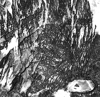
Joints can be conspicuous under certains conditions, where they are long, continuous, wide-spaced and enlarged by erosion. This is well shown by the joint system cutting a basalt flow in Zambia over which flows the Zambesi River (Victoria Falls).
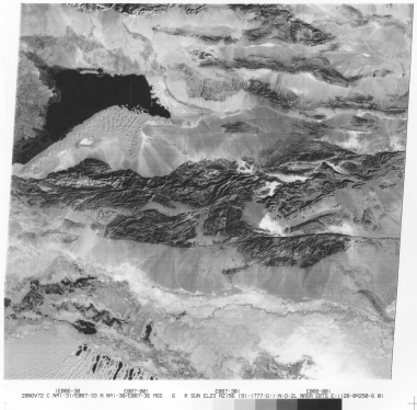
The scene below of the Kuruk
Tagh fault in part of the Tian Shan mountains of westernmost China shows a sharp
fault trace running east-west through the Kuruk Tagh hills. It's composed of folded
sedimentary strata, metamorphic rocks, and igneous intrusions. The block of crust
on the north side has shifted sub-horizontally to the west (left) at least 60
km relative to the block containing the corresponding segment of mountains to
the south. This type is a left-lateral wrench fault (also called a strike-slip
fault). It's a type similar to the San Andreas fault, which is a right-lateral
fault, with the Pacific plate moving northward against the North American plate
the famed earthquake-maker running from the Gulf of California through the California
Coastal Ranges north of San Francisco (see the Los Angeles mosaic further down
this page and the L.A. image in Section 4 and the San Francisco
images in Section 6).
Comparable to the San Andreas
fault is the Dead Sea Fault that runs from just below the mountains of east
Lebanon southward through the Sea of Galilee and the Dead Sea (both actually
lakes), thence into the Gulf of Aqaba. This fault marks one of the three arms
of the Afar Triple Junction (see page 17-3). Here it is shown
in a mosaic made from two Landsat images.
The fault is recognized
in part by topographic discontinuities (mountains in Jordan not fitting with
those on the western side) and because the Jordan River and the two lakes follow
zones of weakness that are erodes so that they are lower than their surroundings
(land adjacent to the Dead Sea has the lowest elevation on land anywhere on
Earth; in places below - 300 feet). The Kuruk Tagh fault in
east Asia, another strike-slip fault, is easy to identify because of topographic
offset (as well as equivalent parts of the strata and metamorphosed rock units),
fault scarps, and displaced drainage. This and similar major wrench faults in
south-central Asia represent crustal adjustments to the stresses induced by
the collision of India against Asia (see mosaic in Section 7).
2-13:
Can you find a second major fault in this scene?
ANSWER Another major fault zone
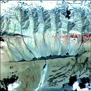
in western China near Tibet is the Kunlun strike-slip (left lateral) system.
In the ASTER image below, the fault has split into two parallel segments. The
lower one has produced a topographic barrier against which water (black) has
been impounded to form a long, narrow lake. Above a series of alluvial fans
is the upper segment from within which water has emerged to flow downslope and
to enable vegetation (red) to grow.
One of the best known and
studied fault zones in the world makes up the East African Rift complex that runs
from Ethiopia south through Kenya (see also Section 3, page 3-2. Here, a part
of Africa is splitting off from the continental nucleus to its west, as an incipient
mid-ocean ridge is forming by rifting centered on the Afar in Ethiopia. This image,
extracted from a photo taken by astronauts using the Large Format Camera (LFC),
shows a number of step faults (of the 'normal' type) which cuts into basaltic
flows making up rift valleys:/p>
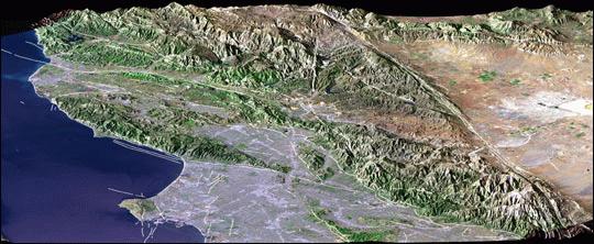
A region in the U.S. famed
for its propensity to earthquakes is much of California from the Mexican border
to about 100 km (62 miles) north of San Francisco. North of the Los Angeles
Basin is a series of mountain ranges trending towards an east-west orientation.
These collectively are known as the Transverse Ranges, and include the San Gabriel
and Santa Monica Mountains north of Los Angeles. They are criss-crossed by faults
that have a strong effect on their topography. Although most of these are wrench
or strike-slip types of faulting (dominantly horizontal slip motion), they are
capable of influencing the fronts of ranges in a manner similar to the normal-type
of fault. Here is a perspective view of the Transverse Ranges made by combining
Landsat imagery with topographic data acquired by JPL's SRTM mission (radar
altimetry). Fault lines have been drawn on the resulting image, which also depicts
the Los Angeles Basin (left) and the Mojave Desert (right).
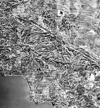
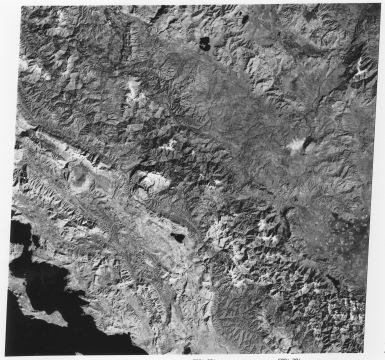
No doubt the most famous
fault in North America is the San Andreas, a major strike-slip type, that runs
from the Gulf of California northward more or less parallel to the California
coastline until it finally passes out to sea as a transverse fault in Bodega
Bay north of San Francisco. In the ranges north of Los Angeles the San Andreas
marks a prominent straight boundary with the southern Mojave Desert. This is
evident in this image which is actually a beautifully produced aerial photomosaic
that includes the Los Angeles Basin, with its many cities, to the south.
An aerial oblique photo
shows the fault in an area of the Coast Ranges in the Carizzo Plains northeast
of Morro Bay. The fault here has a small scarp or cliff to the west of which
the land is slightly higher and dissected.
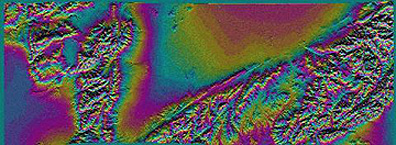
Segments of the San Andreas
have been imaged by Landsat, SPOT, and radar systems many times. Here we show
the latest example: an unusual portrayal of its appearance in a C-band image
specially processed to give landform information, with elevation variation shown
as a series of color bands. The imaging instrument is the Shuttle Radar Topography
Mission (SRTM) that is discussed more fully in Section 11. Compare
this image with the aerial photomosaic shown above: the straight boundary along
the northern Tranverse Ranges in both images stands out. The image orientation
is shifted somewhat from the mosaic, with the Mojave salient apex now pointing
down at the left.
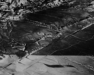
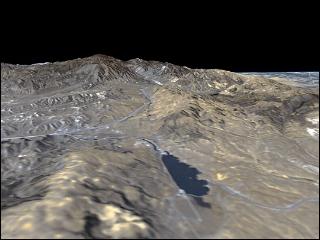
As is described in Section
11 and elsewhere, imagery coupled with elevation data (in STRM's case, from
its own stereo-like capability) can be recast in the perspective mode as though
it is being viewed much like an aerial oblique photo. Here is an STRM construction
of the topography west of Palmdale, Calif. (an earthquake-active area) in which
a somewhat straight valley (holding the lake) roughly coincides with the San
Andreas fault.
Wrench faults have nearly
vertical fault planes (contact surfaces between blocks). A second fault type
is the thrust fault, in which the fault plane is at low angles relative to Earth's
surface and the usual direction of movement carries the upper (near-surface)
block over the lower block, causing rocks of different ages to be juxtaposed.
Thus, a shallow, tabular slice of crust slides (thrusts) over the fault plane
and on top of the surface ahead of it. Several such thrust slices (sheets) may
stack one on top of the other in a staggered pattern, leading to a sequence
of thrust block bands that outcrop in mountainous terrains. If each block consists
of rock types that are different in composition and erosive response, these
will appear at the surface as intervals of rock with contrasting topography.
This topography is superbly displayed in the scene below of the Pindus Mountains
of western Greece and Albania.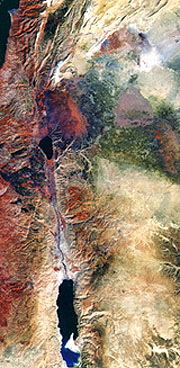

We can differentiate five tectonic zones, named in this generalized map, by sight because of distinct topographic variations and tonal differences related to contrasting rock types. The direction of tectonic transport is from east to west (right to left) causing the sheets to partially overlap below the surface, but each front edge occupies a different geographic position relative to the one it overrode and the one overriding it. This zone of thrust belts is part of the Balkan Alpine system, an offshoot of the European Alps that runs sub-parallel to the Apennine Mountains of Italy (see Alps mosaic in Section 7). As part of the tectonic adjustments caused by the African Plate shoving northward against the European Plate, a small tectonic plate underlying the Tyrrhenian Sea (off Sardinia) is squeezed against the Adriatic plate. The Adriatic plate then pushes it eastward against the Aegian plate, underthrusting it and causing the thrust slicing shown here.
2-14: Which two tectonic zones are hardest to recognize and separate in the above image? ANSWER