A plethora of spectacular surface images have accrued from the Mariner 9 and Viking missions. Below, we show only a few, to whet your intellectual appetite, but for the curious, consult these two references for many more pictures: The Geology of Mars, T.A. Mutch et al., 1976, Princeton University Press and Viking Orbiter Views of Mars, C. R. Spitzer, Ed., 1980, NASA SP-441.
A reminder: As has been alluded to before in this subsection, Mars seems to consist of two dominant terrains - the northern half is mostly a volcanic plains with numerous volcanic phenomena, but is only moderately cratered; the southern part of Mars also consists of igneous (probably volcanic) rock crust but that is much more heavily cratered and has not seen major surface reworking or lava paving. Tectonic features - almost entirely faulting (probably tensional) are found over the entire planet.
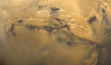
We start with the greatest trench in the ground ever discovered in the solar system. Look at this Viking color mosaic, extracted from the near hemisphere view we showed earlier, here centered on the most conspicuous feature on Mars: the Valles Marineris which extends nearly 4,000 km (2,486 mi) (close to the width of the 48 contiguous United States) and attains depths between 2 and 7 km (1.25-4.35 mi).
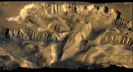
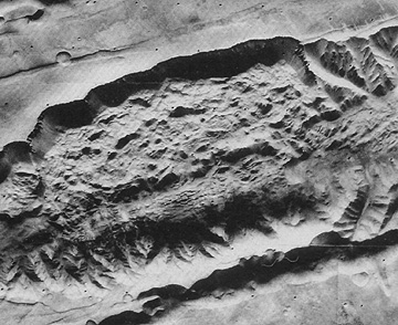
The canyon is actually a series of structural troughs, produced by faulting, radial to the Tharsis bulge to the northwest, which rises some 11 km (6.8 mi) above the surrounding plains, on which are the three dark-shield volcanoes , named on the preceding page. These volcanoes reach about 10 km (6.2 mi) above the bulge. A look inside the canyon wall, along a segment called South Candor Chasma, conveys the sense of steep slopes, perhaps furrowed by water erosion, and basal landslide deposits.
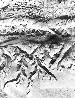
A close-up of a slide in Valles Marineris gives details of the massive debris pile-up, as material pulled away from the steep canyon wall.
Along some edges of Valles Marineris are what appear at first to be tributary valleys. But they don't enter at levels equivalent to the floor base. They seem to criss-cross in a pattern that suggests tectonic control. One proposed explanation has them as due to subsurface water sapping.
19-39: What general explanation can be given for the formation of Valles Marineris? ANSWER
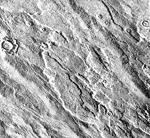
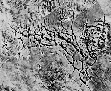
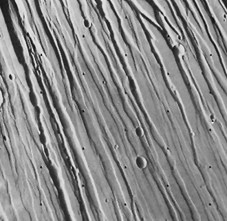
Other tensional grabens are found in various parts of Mars, especially in the newer terrains. These can occur in intersecting networks, such as below which portrays Noctis Labyrinthus in the northern Tharsis region. This tecto-morphological feature is also called fractured terrain.
Sets of subparallel fractures cuts across the terrain on the flank of the Tharsis region (Tharsis is a huge upbulge of martian crust more than 4000 km across and 10 km higher than surrounding lowlands at its top; Olympus Mons and the Tharsis volcanoes attest to it volcanic nature). In overall pattern, the sets are radial to the Tharsis apex. Here is one such set which cuts across older craters (but several younger craters superpose on the fractures).
As is often true for volcanic terrains (such as the East African Rift), sets of close-spaced parallel grabens (fault-bounded downdrop blocks of crust) related to tension induced by loss of support after lava withdrawal have been found also on Mars:
At the other extreme, short fractures may appear as isolated gashes, as seen here. These may be incipient or early stage breaks in a surface undergoing only moderate tensional stress.
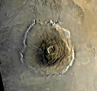
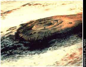
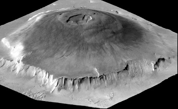
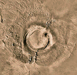
Next, we switch our review to volcanism on Mars. We show (top), from Mariner 9, and later from Viking (center), the huge structure known as Olympus Mons in the Tharsis region, which is a broad shield volcano (now dormant), many times the area and volume of the big island of Hawaii, which consists of basaltic outflows from several major vents. Olympus has a median diameter of 625 km (388 mi) and a height of 25 km (16 mi). Its elliptical central caldera, shown in a zeroed-in view (center), is 80 km (50 mi) in major axis. Olympus Mons is the largest volcanic structure known on any of the planets. A cliff 6 km (3.7 miles) high surrounds it, and stands out in the perspective view (bottom), derived by combining an image with topographic data obtained from laser altimeter data. Scientists still debate the origin of this cliff, but some of them cite it as evidence of an escarpment resulting from wave erosion by an ancient (now vanished) ocean that may have covered at least part of Mars. Note the distinctive grooved terrain (volcanic origin?) beyond the volcano's edge.
19-40: This steep cliff around Olympus Mons is peculiar and not characteristic of terrestrial shield volcanoes. Speculate on a possible origin. ANSWER
There are three volcanoes lined up in the Tharses Montes area east of Olympus Mons; from south to north they are Arsia Mons, Pavonis Mons, and Ascraeus Mons. Each is a large shield volcano with a well developed central caldera. Typical is Arsia Mons, about 300 km (200 miles) wide at its base:
One of the best formed
volcanoes in Bilbis Patera, which lies between Olympus Mons and the Tharsis
group. As seen here by Viking Orbiter 1, the base of the volcano is about
100 km (62 miles) in diameter. The caldera is large compared to the total
size, like some volcanoes in the Galapagos Islands off the Ecuador coast.
The largest volcanic
structure on Mars is the great bulge in the northern Tharsis region known
as Alba Patera, only a few kilometers high but 1600 km (1000 miles) in longest
dimension. As such, it rates as the largest shield volcano in the Solar
System.It is broken by a series of concentric fractures and a set of elongate,
subparallel fracture grabens, as seen in this Mariner mosaic.
At Alba Patera's top
are an older summit caldera (left) and a smaller, more recent one. Note
the lava flows descending its gentle slopes.
Alba Patera's flanks
show numerous overlapping flows, indicating multiple periods of lavas extruded
from tube outlets both at the caldera and along the slopes. In this Viking
Orbiter image, the flows are flat-topped but steep-sided; volcanic ridges
appear in the lower left.
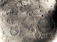
Extensive impact cratering
was observed by Mariner 4, which sent back the first ever images (21 all
told) taken of another planet's surface (one seen in the top photo below)
by a space probe that approached to within 9800 km (6086 miles). As imaged
the next year by Mariner 6, the Sinus Sabeus region of the southern highlands
(bottom) preserves typical impact craters in the ancient terrain that apparently
has not been extensively resurfaced by lavas. Note that none of the larger
craters in this view have central peaks.
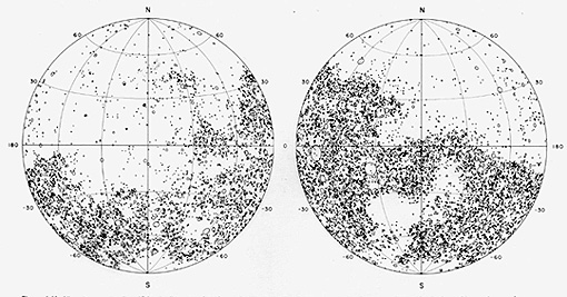
Mariner 9 and the Vikings
confirmed that a large fraction of the (older) martian surface mainly in
the southern hemisphere remains heavily cratered. This is evident in this
sketch drawing from Mutch et al., The Geology of Mars, 1976 in which
all craters larger than 15 km are positioned.
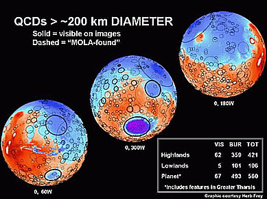
A recent study made
by a colleague of the writer (NMS), Dr. Herbert Frey of NASA Goddard - assisted
by his teen age daughter Erin - has led to a map of the distribution of
large surface-visible plus now buried impact structures that nevertheless
show circular surface manifestations. The latter have been located using
the MOLA laser altimetry data.
One can argue that this
landscape has many similarities to the still cratered Earth in its early stages
before extensive water had collected into major oceans. Likewise, buried impact
structures can be discerned on the lunar surface. These have since been covered
by lunar ejecta. This may mean that the martian surface is also covered by
ejecta deposits that spread over older craters.
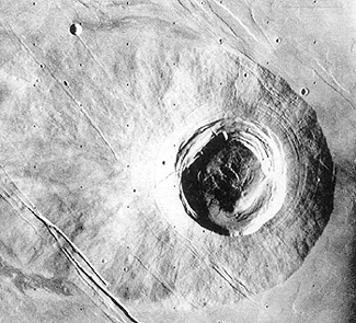
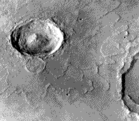
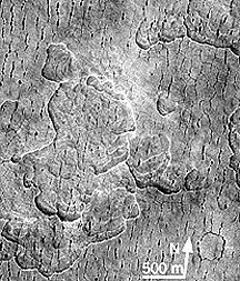
Some of the martian
impact structures retain well-preserved ejecta blankets that display prominent
lobes, such as seen here around the crater Yuty. The ejecta was probably
fluidized by vaporization of carbon dioxide-rich ice lying just beneath
the surface.
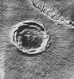
One type of impact
crater is different from those on the Moon, Mercury and Venus in that the
edge of the ejecta blanket has a steep scarp, evident in the Viking image
below, or even a peripheral rise called a rampart. This type is called a
pedestal crater.
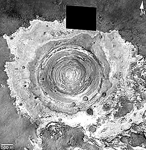
This next crater is
small, young, and shows most of the same features as do terrestrial craters.
Located in Terra Meridiani, this crater is 2.6 kms wide (1.6 miles; rim
to rim), has at least 1 nested slump zone in its interior and a distinct
exterior ejecta blanket, and has exposed what appears to be internal layering
of the martian surface units. The image was made by the Mars Global Surveyor.
Still another large
impact crater, Poona, has a remarkable uniform set of rays, equispaced
over the full 360° around the rim:
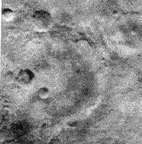
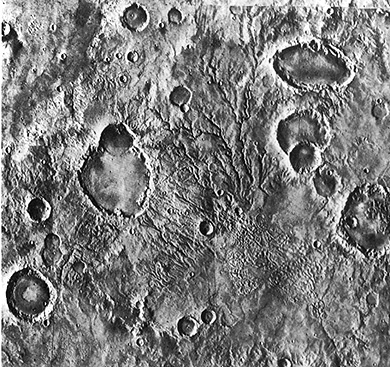
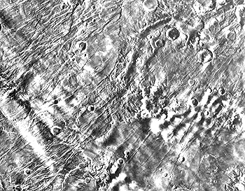
This next Viking
scene, in the southern Highlands, seems to have both impact and volcanic
craters. Some without ejecta beyond their rims, especially the elliptical
one, are calderas. Several others have aspects more characteristic of
degraded impact structures. This was an active region, with channels (either
volcanic or stream) and other types of terrain.
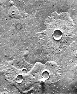
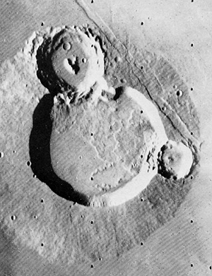
Now look at these
three craters (Ulysses Patera):
19-41: What type(s) of craters are present in this Viking scene
(the largest structure is about 80 km [50 miles] across at its base)?
ANSWER