During the preceding Sections we talked about individual satellites, each in its own orbit and making measurements usually independent of other co-operational satellites. But the notion of multi-sensor and multi-platform satellites has already been introduced. Thus, when more than one Landsat or SPOT or IRS, etc., satellite is in orbit and functioning at any given time, the possibility of multitemporal data gathering is activated. Weather satellites are a prime example of having different satellites all looking at the Earth during a given period of time. Data from them can be correlated and integrated to provide information on weather during any specified day. Another variation of such integration occurs when data from simultaneous observations or successive observations or from different platforms are combined by some mode of registration, usually done through computer processing.
In the past 10 years or so, and especially in recent years, the concept of satellite formation flying has crept into the thinking of those seeking different approaches to new programs. Some have described their awareness of birds, such as geese, flying in structured flocks (or bombers in the Second World War) as the source of this concept. Formation flying can be defined as "groupings of duplicate or similar satellites, having sensors in common or are complementary (related), that talk to each other and share data processing (onboard and/or by means of utilizing comparable ground stations and facilities), payloads, and mission functions." The multiple satellites are, in one or more ways, said to be synchronized. Two sites that briefly overview satellite formation flying are found at these SpaceFlight Now and E0-1 sites.
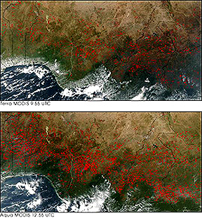
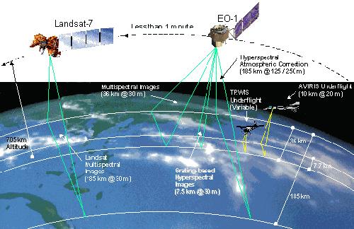
The Terra/Aqua pair and other EOS satellites are part of an integrated series of satellites that will, in effect, be prime examples of formation flying or synchronization. Terra is in formation with Landsat-7, EO-1, and SAC-C. Aqua, which follows Terra orbital pathways about 3 hours later, will eventually be joined by CALIPSO, CloudSat, PARASOL, and Aura.
This image shows the value of flying the Terra-Aqua pair in close formation in which each satellite covers the same area on the same day but separated by several hours when passing over a scene. At 9:55 AM Terra imaged the Central Africa coastal part of western Nigeria. At that time, a large number of small fires deliberately set by local farmers (the "slash and burn" custom) to clear the land for a new crop planting are clearly evident. When Aqua passed this scene 3 hours later, the number of fires had increased significantly.
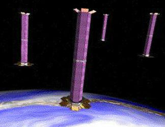
The classic example of formation flying is given by the Global Positioning System (GPS), which we considered earlier on Page 11-6. There we learned that the U.S. is operating a program called NAVSTAR which facilitates location of any point on Earth to a high degree of accuracy (read that page for principles; you are probably familiar with some of its many applications, such as getting directions while driving your expensive car, locating yourself while hunting, or sending your position when shipwrecked at sea). A NAVSTAR satellite looks like this:
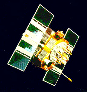
At present there are 27 operational NAVSTAR satellites (24 in the basic array; three others as "spares" or "reserves" to be emplaced as individuals fail). They all support the same sensor system, essentially a radio transponder which communicates with receivers distributed worldwide and linked to parent ground stations. Their orbits are carefully specified and maintained to have mutual regularity in spacing. Thus:
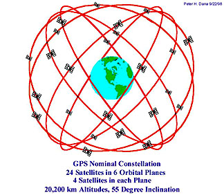
When plotted on a flattened global projection, the regularity of the orbital paths becomes apparent:
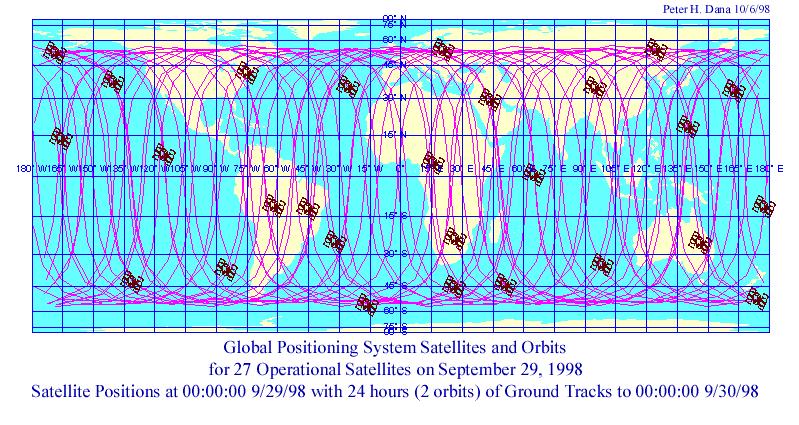
This type of formation flying is known as the "Constellation" configuration. The satellites are moderated space at considerable distance from one another but can maintain communication with one another as well as with ground stations. Another configuration of similar satellites is called "Cluster", in which a small group of satellites are located relatively close to each other as they follow orbits that permit them to remain the same distances apart. Here is a suggested arrangement of a group that would comprise the TechMap 21 system:
Still another formational configuration can be termed the "Trailing" mode. It is illustrated by the present pairing of Landsat 5 and EO-1 which follows the first satellite in the same orbit, so that EO-1 crosses the same "real estate" at a slightly later time (about 1 minute). This diagram illustrates the two satellites in their common orbit and includes some of the operational parameters.:
An obvious advantage to this
is that the trailing satellite not only sees slightly different temporal conditions,
but can be equipped with one or more different sensors that provided additional
sensing capabilities. In other words, if new sensors with improvements or operating
in different parts of the spectrum are developed after the earlier satellite is
placed in orbit, it would be next to impossible to add these to that satellite
but the second satellite would be so close to the first in time and space, so
that the effect is almost as if the sensor(s) has been emplaced on the first one.
One added benefit in grouping
satellites in a co-ordinated program is that, under appropriate circumstances,
each can be built and launched at lower costs. And, if one of a group fails
after orbiting, the cost of replacing it would normally be less that replacing
or Shuttle-servicing a large satellite operating as a stand-alone. Among candidates for formation
flying are very small and lightweight satellites called nanosatellites (under
10 kilograms [22 pounds]), or larger cousins called microsatellites (under 100
kilograms). An example of the first is the experimental communications satellite
called SNAP-1 (shades of the first Sputnik!) developed by the University of
Surrey, and shown here:
Another example of formation
flying of small objects will be the Magnetospheric Constellation, consisting
of 100 microsatellites whose orbits are set to provide simultaneous coverage
on a global scale. A useful review of the small satellite synchronized operation
is given in the Leonardo concept. Application categories
especially suited to formation flying include astronomy observers, communications,
meteorological and climate , and environmental. In astronomy, multiple satellites
at specific spacings open up the opportunity to use them as components in an
array that permits the principles of interferometry to increase effective resolution.
JPL is planning a project called Starlight
that will use a spread of space telescopes whose effective observational base
is significantly widened; scheduled for 2006, its primary goal is to search
for planets. Another JPL mission, planned for 2009, SIM, using multiple
spacecraft to study stars by interferometry. A major effort is underway
to combine and coordinate programs to gather environmental and meteorological
data now acquired independently by several agencies. Thus, NASA, NOAA, and the
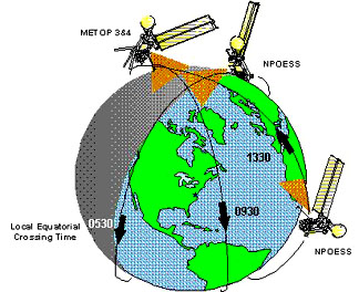
Dept. of Defense are joing forces to set up NPOESS (National Polar Orbiting
Environmental Satellite System), scheduled to be fully operational around 2008.
Three satellites, each with up to 10 sensors (most but not all duplicated on
each satellite), will be placed in orbits that cross the equator at times four
hours apart. This is the current planned configuration:
The new spacecraft will
be modeled after the present day POES program run by NOAA. More about this ambitious
scheme can be learned by visiting these online sites: Air Force participation
and NOAA, which describes some
of the candidate sensors. Tasks considered for this grouping include improved
3 to 5 day forecasts, storm tracking, and crop management. Prior to launch,
the proof of concept will be tested by the OSSE (Observing System Simulation
Experiment). To close, this last page
highlights a trend illustrated by the EOS series of using pairs to multiples
of satellites that fly in regular patterns, spacings, or time separtions, such
that, coordinated together, the result is a symbiotic increase in information. The next page gives some
useful references and further reading pertaining to the EOS program.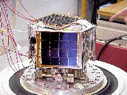 ">
">