On this page we will try to summarize the several meanings associated with the "multi" concept covered in the preceding three pages. We will choose a single part of the Earth where a sequence of recent natural events associated with one locality have been attracting worldwide attention. Using primarily numerous ground and space images, this event will be examined using multiplatforms, multisensors, and multitemporal coverage.
The event is the repeated series of eruptions of one of the world's most famous volcanoes - Mt. Etna near the northeast tip of Sicily where that island lies west of the Straits of Messina at the toe of the "boot" of Italy. This volcano, of the Strombolian type (Stromboli lies just to the north), is the most active in Europe and, for that matter, is the oldest timewise in Man's historical knowledge (recorded) of active, erupting volcanoes. The earliest documented mention goes back to about 2000 BCE; Etna has erupted 192 time since. Two series of eruptions, in 2002 and in 2002, will be studied here.
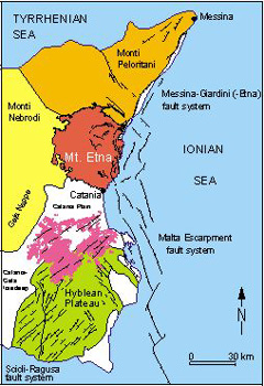
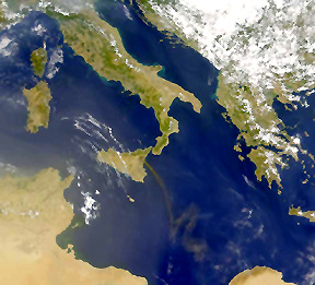
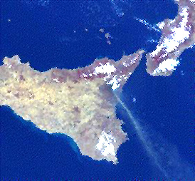
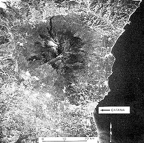
First, let us establish a general geologic setting, shown in this map; the exposed volcano itself covers about 1200 square kilometers:
Being a part of the great alpine system of folds and faults that resulted in the northward movement of the African tectonic plate against the Mediterranean and the European plate to its north that resulted in the Alps and Apennines, the rocks exposed in Sicily are strongly deformed into folds, nappes, and faults. The dominant rock type here, and throughout much of the alpine system, is limestone and other carbonates. Mt. Etna seems to overlie a "hot spot" where plumes of molten rock approach or reach the surface (Vesuvius and Vulcano in southern Italy are other examples). Etna's volcanic rock is intermediate silicic (trachyandesite; some basalt) and many lava flows have aa surfaces; scoria and bombs are common. Both pyroclasic (ash) and flow eruptions are the usual mode. The lavas come from at least two shallow magma chambers, each of which seems to be fed by a deeper large magma reservoir at a depth of greater than 50 kilometers.
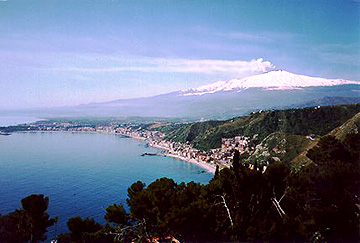
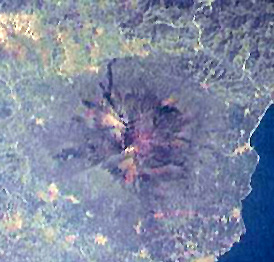
Mount Etna has a conelike structure but with gentler slopes than characteristic of stratovolcanoes; it resembles somewhat the shield volcano that makes up Mauna Loa on the Island of Hawaii. The summit, which has a caldera, reaches to 3350 meters (10991 ft). Of that, only the upper 2000 meters are volcanic; this edifice of interleaved pyroclastics and flows rests on a sedimentary rock base. Here is a view of this snow-capped peak as seen from near Messina, looking west-southwest.
The chances are better than even that at any visit, smoke will be issuing from the vent.
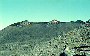
Most of the upper half of Mt. Etna is relatively barren of vegetation; its surfaces show evidence of many previous flows and channeling.
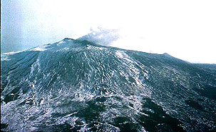
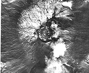
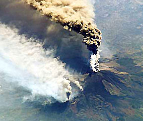
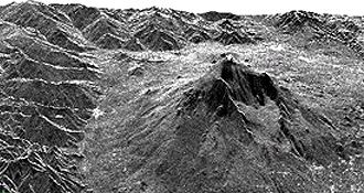
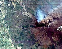
The summit itself is shown first in an aerial photo and then in a ground photo:
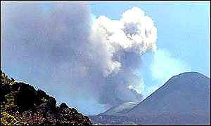
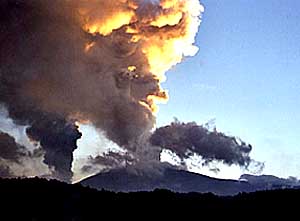
The next six photos were taken from the ground at various times during eruptions that took place intermittently between 1999 and the end of 2001. The first shows the ash-steam cloud at sunset.
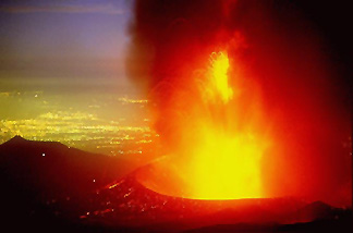
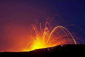
Here is a nighttime view of crater eruption; the yellow spots are lights in small villages and individual homes.
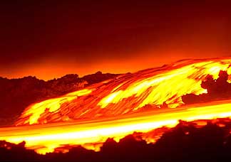
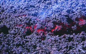
Lava flows down the sides of Etna were common.
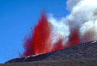
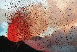
Fire fountains are jets of lava pushed upward by gases during an eruption. The first below comes from a curtain of lava ejected along a fissure; the second is a fountain coming from a spatter cone.
After an eruption involving lava flow, the surface is typically one of "aa" (clinker-like individual fragments), as seen here:
NOTE: In preparing this section (Feb. 2003), the writer (NMS) has decided to "kick himself" for having missed an opportunity to see the Etna fireworks for himself. He was the instigator and co-author of Volcanic Landforms and Surface Features, a large picture atlas published in the early 1970s but has never seen an eruption anywhere. We had plans to go to Greece in 2001 but had to abort. Perhaps there's still time left.
Now we are ready to study Mt. Etna from space. Most of the scenes below result from July-August, 2001 and October-November, 2002 eruptions; a few scenes were acquired in 1999-2000.
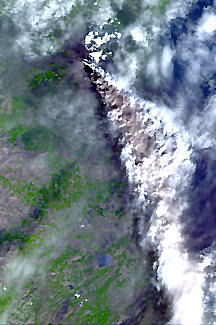
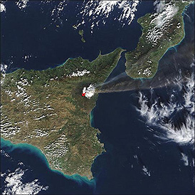
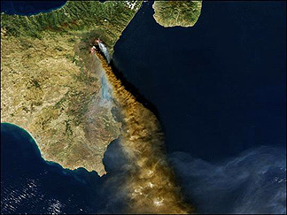
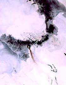
For a regional perspective, look first at this October, 2002 SeaWiFS image
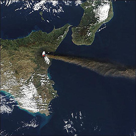
This view of actively-erupting Mt. Etna was obtained by the Orbview-2 satellite
The Atmospheric InfraRed Sounder on EOS's Aqua is capable of making regional imagery; thus:
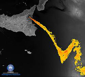
The ATRS (Along Track Scanning Radiometer) can provide different aspects of a ground scene. Here the island of Sicily is dark but the plume from Etna has been colored yellow.
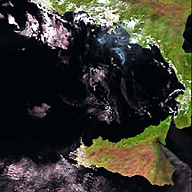
Or, the scene can be presented by ATRS in a quasi-true color mode
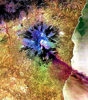
The Medium Resolution Imaging Spectrometer (MERIS) on Envisat can produce images with different colorations. The two scenes below, focusing on Mt. Etna, show differing renditions:
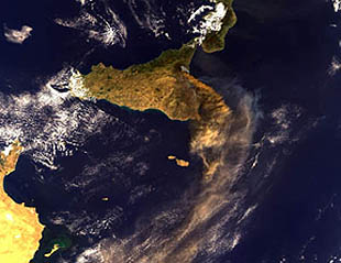
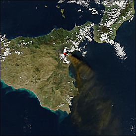
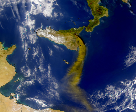
SeaStar, a European satellite that concentrates on oceanographic states, also produces adequate displays of land surfaces, here showing all of Sicily with an active Mt. Etna.
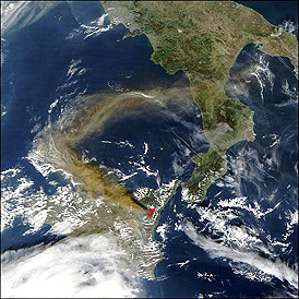
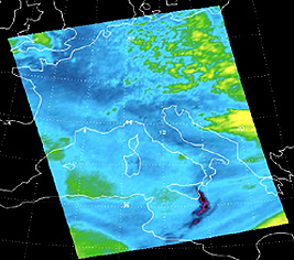
Satellites used in meteorological studies can be processed to highlight small areas. Here is a DMSP (Defense Meteorological Satellite Program) image of the area around Mt. Etna.
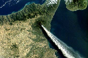
An Etna eruption was seen and photographed by an astronaut on the International Space Station as it passed just south of Sicily. The result is much like an aerial oblique photo but covers a much larger viewing area.
Here is another ISS astronaut image taken with a different camera on July 22, 2001.
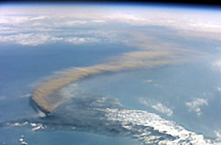
On another occasion, an astronaut took this downwind view concentrating on the smoke plume itself.
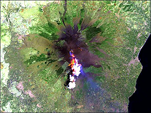
Landsats have passed over Mt. Etna many times since 1973. This is a false color composite subscene obtained by the TM on Landsat-5.
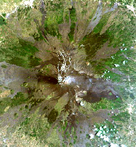
Individual TM bands can be instructive. Here is a Band 5 subscene image of Mt. Etna as imaged by Landsat-7. The light tones highlight areas where vegetation is prominent.
Many of the Etna images on this page attempt to render the scene in natural color. Here is a Landsat TM version:
Using longer wavelength bands to include in the color composite yields colorful images, such as this one made with Bands 4, 5, and 3 as red, green, and blue respectively:
And note this Landsat-7 color composite; compare it to the ASTER image seen below - they are almost identical in the renditions shown, since similar bands (chosen to simulate true color) were used.
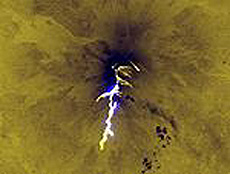
This interesting subscene was taken using the thermal band on Landsat-7 during a night pass on August 5, 2001. The hot lava flows stand out.
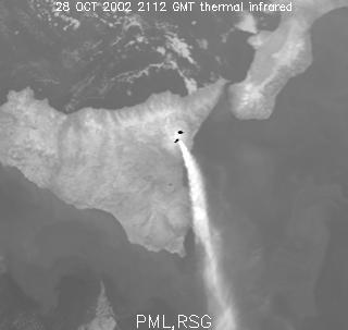
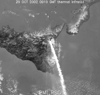
Meteorological satellites are effective at placing Mt. Etna into context. Those with a thermal channel can also pinpoint the active hot spots on the summit and flanks. These two images were gathered duringg the nights of October 28 and 29, 2002 respectively.
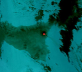
This Metsat (this term is used for any meteorological satellite whose specific identity is not given) image has been processed to show Sicily in the night as dark except for the bright orange of surface lava, with its strong thermal signal.
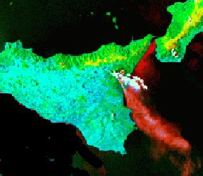
A daytime Metsat image has been reprocessed to give a color version in which the land is green and the Mt. Etna smoke plume is red.
A thermal channel on the ERS-2 ATSR (described above) produced the next two images, both taken at night.
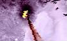
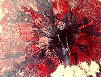
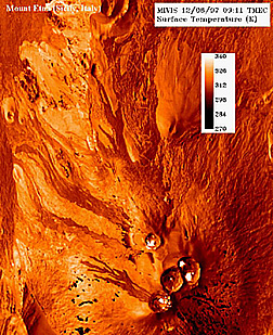
An experimental aircraft-mounted hyperspectral sensor (see following pages in this Section) called MIVIS produced this image of the surface temperatures near the summit of Mt. Etna.
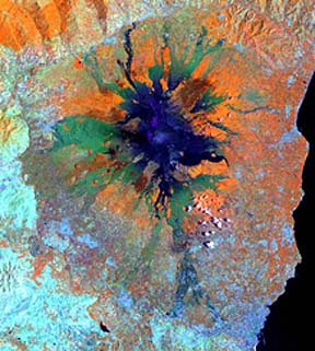
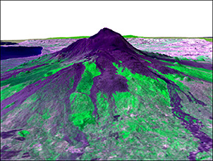
Radar is also quite useful for studying land surface conditions, such as topography (and changes thereof), around Mt. Etna. This next image is a SIR-C C-Band and X-Band color composite of Mt Etna and surrounding terrain. North is to the right.
As was discussed in Sections 8 and 11, perspective views of surface topography, in this case Mt. Etna as imaged by SIR-C, can be produced using either elevation data from maps or from onboard altimeters.
The SAR radar on ERS-2 provided both scene and altimetric data needed to generate this perspective view:
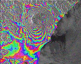
As was explained on pages 11-8 - 11-10, radar interferometry is capable of indicating changes in surface heights or elevations. Here is the interference ring pattern that was determined from ERS-1 data acquired in 1995. This suggests some ground swelling.
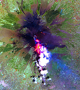
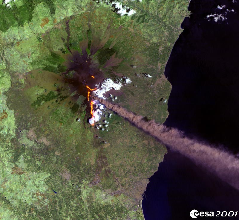
One of the hallmarks of the smoke plumes from most Mt. Etna eruptions is a relatively high SO2 content, mixed with steam and ash. This is an ATRS image of an eruption on July 21, 2001 at Mt. Etna. Bands 7, 5, 2 (RGB) were combined to make the image.
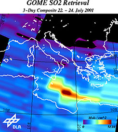
On board that spacecraft is the GOME (Global Ozone Monitoring Experiment) sensor which can provide quantitative measurements of SO2 content. The map below shows the distribution of SO2 summed over the period between July 22 and 24, 2001.
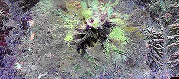
Another ESA satellite, PROBA (Project for Onboard Autonomy) monitored Mt. Etna during the first stages of eruption in 2002. The next two images show both the CHRIS and the HRS sensor products obtained then.
We come now to images generated from several sensors on the EOS program's Terra and Aqua satellites. These satellites are described in detail in Section 16. They are among the most versatile earth-observing satellites now in orbit.
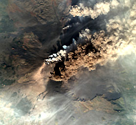
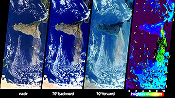
The first image from Terra was made by the MISR sensor which is capable of looking at the scene simultaneously at several fixed angles.
Terras's ASTER is able to
produce images using or combining visible, near-IR, and thermal band data. Here
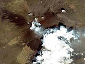
is a near true-color ASTER image:
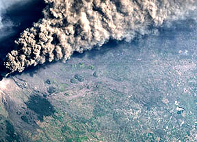
An earlier monitoring of
this eruption, in early August of 2001, produced this striking view of the hot
lava fields, as imaged by Terra's Aster.
In this next ASTER image,
one of the thermal bands is included in making the false color composite.
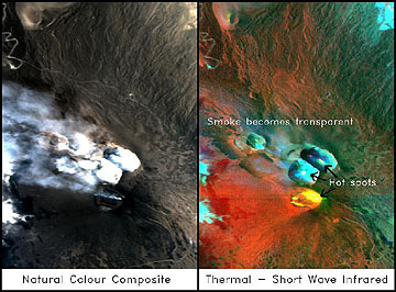
ASTER can pinpoint the
hot lava extruding from its sources high up on Etna. This set of views shows
a color composite for context and two thermal band views showing these hot spots:
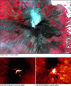
We will now use the MODIS
sensor on Terra to do a time sequence study of the changes in smoke plume directions
over a short span between November 3 and October 28, 2002. See the captions
for details:
In late October of 2002
Etma was imaged at high resolution during a pass by Digital Globe's Quickbird-2.
The view shown here is somewhat degraded so as to fit the screen. The image
downloaded from the DigitalGlobe site, as shown with many megabytes, is remarkable
for its detail - comparable to high quality aerial photography.
Space Imaging's IKONOS
has obtained a number of Mt. Etna images, but only one was found through the
Internet. Here it is, at a resolution of 4 meters.
Later on in this Section
we will concentrate on the relatively new technology of Hyperspectral sensors.
For now, we show a scene (shown again and explained on page 13-10 made of Mt.
Etna by a European hyperspectral system called DAIS (see page 13-9).
Etna then is one of the
more active, and often spectacular, erupting volcanoes in the world. However,
the many recorded eruptions cannot be marked as violent (like Krakatoa or Thera),
yet at least one having that savage nature did occur in the past and some volcanologists
predict another catastrophic eruption in the future. A thorough review of Mt
Etna's behavior is found in the April 2003 Scientific American article
entitled "Mount Etna's Ferocious Future". We alluded to the other
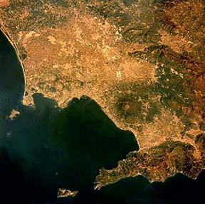
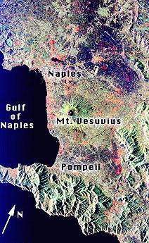
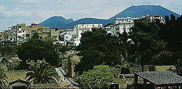
famous volcano in Italy - Vesuvius, perilously close to Naples. This still active
stratocone lies just inland between Naples and Pompei. The next two images establish
the geographic context of this volcano:
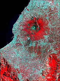
Much more detail is evident
in this ASTER false color image. It shows both a partial outer rim and a small
volcanic cone with the depression at the top of Vesuvius.
In 79 A.D., a sudden violent
eruption of Vesuvius blew its top and sent huge glowing ash clouds towards the
Bay of Naples. Everyone in towns like Herculaneum and Pompeii were buried alive
by these "nues ardentes" (hot ash that hugs the surface, moving downslope much
like an avalanche). Both towns have been exposed as they were by archeological
digs that removed the ash cover.
We take leave now of this
part of Section 13 that has dealt with ground truth and the "multi" concept
to advance to an introduction to hyperspectral remote sensing after some principles
of spectroscopy are espoused.