<>
10-1:
For the moment we shall define resolution in a photograph as the
size of the smallest object whose tonal appearance is notably different
from its surroundings or background; technically there is a more precise
definition, given in terms as the minimum spacing between two dark lines
embedded in a light background that can be visually separated. How does
spatial resolution vary in this oblique photo. ANSWER
The second type of aerial
photos is oriented vertically, that is, it results from pointing the camera
straight down (to the nadir, at the photo center point) to show the surface
directly from above. The size of the photo and the sizes of the features represented
within the photos can vary depending on the following: the camera's optical
parameters, the surface area of the exposed film (frame size), the subsequent
printing sizes (e.g., enlargement), and the altitude of the camera platform.
The ratio of the size
of any object, feature, or area within the photo to its actual size in the
picture is called the scale (defined and discussed on the third page
of this Section).
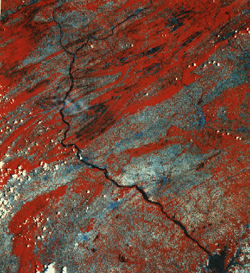
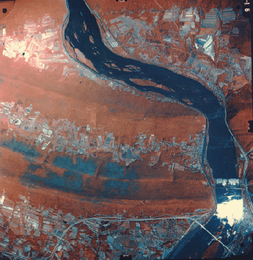
We now present a series
of aerial photos, acquired at different times and scales, most covering
areas that lie within this June, 1977, Landsat image (scale = 1:1,000,000)
of south-central Pennsylvania, a scene we have looked at in earlier sections,
and especially during the Exam
at the end of Section 1.
This scene contains
heavily forested fold ridges. Some of the bluish-black areas are defoliation
patches caused by the Gypsy Moth. Others areas near top center are surfaces
covered with black dust from the Anthracite coal strip mining in fold valleys.
Bluish areas in the wide valleys are fields still bare or with early stage
growth. The Susquehanna River which empties into the top of Chesapeake Bay
bisects the image. Near the left center, a blue pattern with spokes is Harrisburg,
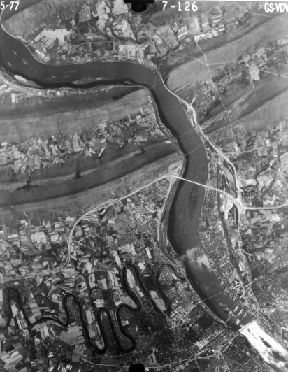
the state capital, with York below it and Lancaster to the right. Next,
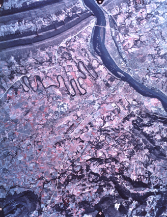
we show a standard medium-scale ( moderate area of coverage but with considerable
detail [individual buildings still visible]), black and white aerial photo
of part of Harrisburg. The scale value given is that of the original photo
before it was reduced to your screen size; quoting this value helps to appreciate
what can be seen (resolved) at that scale, no matter what the eventual picture
size becomes through enlargement or reduction.
Harrisburg (Scale
= 1:100,000)
The number in the upper
left corner of this black and white photo of Harrisburg is the date; on the
right is the Mission number; and in center is a number denoting the flight
line and particular photo within that line. Individual fields, smaller rivers,
bridges, and roads are easily picked out.
10-2:
One meaning of scale is this: 1 inch on the photo equals X inches
on the ground. For the 1:100,000 photo above, determine how many feet are
represented by an inch (on the photo, or in this case, the image on your
screen) and likewise how many mile(s) extend across that inch.
ANSWER
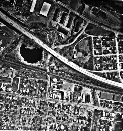
The next photo is large
scale (small coverage area and high resolution for identifying features
smaller than buildings, e.g., cars) and covers an area within Harrisburg,
just east of the previous photo, bisected by Interstate 83. Note particularly
the lake-filled quarry (left center).
10-3
In which other photo on this page can you find the quarry lake?
For the above photo, what is/are the number of miles represented by an inch
on the screen? Make an educated guess as to the effective resolution of
this 1:4000 photo; how did you do it? ANSWER
Image Scale