Abstract: Wetlands of India, estimated to be 58.2 million hectares, are important repositories
of aquatic biodiversity. The diverse ecoclimatic regimes extant in the country resulted in a
variety of wetland systems ranging from high altitude cold desert wetlands to hot and humid
wetlands in coastal zones with its diverse flora and fauna. The review deals with the status
and distribution of wetlands and causes and consequences of wetland losses. It also provides an
overview of the use of Remote Sensing and Geographic Information System (GIS) tools in flood
zonation mapping, in monitoring irrigation and cropping patterns, water quality analysis and
modelling, change analyses and in mapping of surface water bodies and wetlands. The review
provides a methodology and an action plan for evolving a nationwide network of conservation
preserves of wetlands. The major elements of this methodology involve use of IRS LISS III sensors
for delineating turbidity, aquatic vegetation and major geomorphological classes of wetlands.
An extensive fieldwork to generate attribute information on biodiversity and socioeconomic
themes is a significant component of the suggested methodology. GIS tools to integrate
habitat information with the field information are envisaged to be the final component in evolving
a conservation network of wetlands for the entire country.
Resumen: Los humedales de la India, cuya superficie estimada es de 58.2 millones de hectáreas,
son depósitos importantes de la biodiversidad acuática. Los diversos regímenes ecoclimáticos
que existen en el país han dado por resultado una extensa gama de sistemas de humedales
que abarca desde los humedales de desierto frío de alta altitud, hasta los humedales
cálidos y húmedos de las zonas costeras con su flora y fauna diversas. La revisión versa sobre la
condición y la distribución de los humedales, y las causas y consecuencias de su pérdida. También
proporciona una visión de conjunto sobre el uso de herramientas de Percepción Remota y Sistemas
de Información Geográfica (SIG) en la elaboración de mapas de la zonación de inundación, el
monitoreo de patrones de irrigación y de cultivo, el análisis de calidad de agua y su modelado, el
análisis de cambios y en la elaboración de mapas de cuerpos de agua superficial y de humedales.
La revisión hace una sugerencia metodológica y ofrece un plan de acción para la creación de una
red nacional de reservas para la conservación de humedales. Los principales elementos de esta
metodología involucran el uso de sensores IRS LISS III para definir la turbidez, la vegetación
acuática y las principales clases geomorfológicas de los humedales. Un componente significativo
de la metodología sugerida es el trabajo extensivo de campo para generar la información tanto de
atributos de biodiversidad como de temas socioeconómicos. Se prevé que las herramientas de SIG
para integrar información de hábitat con información de campo serán el componente final en la
conformación de una red de conservación de humedales en todo el país.
Resumo: As terras húmidas da Índia, que estão avaliadas em 58,2 milhões de hectares, são importantes repositórios de biodiversidade aquática. Os diferentes ecoclimas existentes no
país caracterizam-se por uma variedade de sistemas húmidos oscilando dos desérticos frios de
alta altitude aos quentes e húmidos das zonas húmidas costeiras com a sua flora e fauna diversificada.
Este revisão trata do status e distribuição das zonas húmidas e causas e consequências
da perda destes zonas. Ela proporciona, também, uma visão de conjunto do uso das ferramentas
de Detecção Remota e do Sistema de Informação Geográfica (GIS) nos mapas de zonagem,
monitorização da irrigação e dos padrões de cultura, análise da qualidade da água e modelação,
análise das mudanças e mapeamento dos cursos de água e das terras húmidas. A revisão proporciona
a sugestão de uma metodologia e um plano de acção para envolver uma rede nacional
de conservação e preservação das terras húmidas. Os maiores elementos desta metodologia envolvem
o uso dos sensores do IRS LISS III para delinear a turbidez, a vegetação aquática e as
principais classes geomorfológicas das terras húmidas. Um trabalho de campo extensivo para
gerar informação sobre os atributos da biodiversidade e temas sócio-económicos, é uma componente
significativa da metodologia sugerida. A utilização das ferramentas do GIS para integrar
a informação sobre o habitat com a informação de campo, é encarada como a componente final
no envolvimento de uma rede de conservação das terras húmidas para todo o país.
Key words: Aquatic vegetation, avifauna, conservation, fishes, geographic information system (GIS),
protected areas, remote sensing, tropical wetlands.
Introduction
Wetlands are defined as ‘lands transitional between
terrestrial and aquatic eco-systems where
the water table is usually at or near the surface or
the land is covered by shallow water (Mitsch &
Gosselink 1986). The value of the world’s wetlands
are increasingly receiving due attention as
they contribute to a healthy environment in many
ways. They retain water during dry periods, thus
keeping the water table high and relatively stable.
During periods of flooding, they mitigate flood and
to trap suspended solids and attached nutrients.
Thus, streams flowing into lakes by way of wetland
areas will transport fewer suspended solids
and nutrients to the lakes than if they flow directly
into the lakes. The removal of such wetland
systems because of urbanization or other factors
typically causes lake water quality to worsen. In
addition, wetlands are important feeding and
breeding areas for wildlife and provide a stopping
place and refuge for waterfowl. As with any natural
habitat, wetlands are important in supporting
species diversity and have a complex of wetland
values.
The present review is aimed at providing in a
nutshell, the distribution of wetlands, the value of
wetlands, the causes and consequences of the loss
of wetlands. The review attempts to provide a
glimpse of the use of modern spatial technology
tools, viz. Remote Sensing / GIS for obtaining an
assessment, description and monitoring of inland
wetlands. The review also gives a methodology for
an ongoing nationwide attempt on evolving a conservation
area network or a protected area network
of inland wetlands.
Distribution of wetlands in India
India, with its annual rainfall of over 130 cm,
varied topography and climatic regimes support
and sustain diverse and unique wetland habitats.
Natural wetlands in India consists of the highaltitude
Himalayan lakes, followed by wetlands
situated in the flood plains of the major river systems,
saline and temporary wetlands of the arid
and semi-arid regions, coastal wetlands such as
lagoons, backwaters and estuaries; mangrove
swamps; coral reefs and marine wetlands, and so
on. Infact with the exception of bogs, fens and typical
salt marshes, Indian wetlands cover the whole
range of the ecosystem types found. In addition to
the various types of natural wetlands, a large
number of man-made wetlands also contribute to
the faunal and floral diversity. These man-made
wetlands, which have resulted from the needs of irrigation, water supply, electricity, fisheries and
flood control, are substantial in number. The various
reservoirs, shallow ponds and numerous tanks
support wetland biodiversity and add to the countries
wetland wealth. It is estimated that freshwater
wetlands alone support 20 per cent of the
known range of biodiversity in India (Deepa &
Ramachandra 1999)
Wetlands in India occupy 58.2 million hectares,
including areas under wet paddy cultivation
(Directory of Indian Wetlands). Majority of the
inland wetlands are directly or indirectly dependent
on the major rivers like, Ganga, Bhramaputra,
Narmada, Godavari, Krishna, Kaveri, Tapti. They
occur in the hot arid regions of Gujarat and Rajasthan,
the deltaic regions of the east and west
coasts, highlands of central India, wet humid
zones of south peninsular India and the Andaman
and Nicobar & Lakshwadeep islands.
Indian wetlands are grouped as:
Himalayan wetlands
Ladakh and
Zanskar
: Pangong Tso, Tso Morari, Chantau,
Noorichan, Chushul and Hanlay
marshes
Kashmir
Valley
: Dal, Anchar, Wular, Haigam,
Malgam, Haukersar and Kranchu
lakes
Central
Himalayas
: Nainital, Bhimtal and Naukuchital
Eastern
Himalayas
: Numerous wetlands in Sikkim,
Assam, Arunachal Pradesh,
Meghalaya, Nagaland and Manipur,
Beels in the Brahmaputra and
Barak valley
Indo-Gangetic wetlands
The Indo-Gangetic flood plain is the largest
wetland system in India, extending from the river
Indus in the west to Brahmaputra in the east. This
includes the wetlands of the Himalayan terai and
the Indo-Gangetic plains.
Coastal wetlands
The vast intertidal areas, mangroves and lagoons
along the 7500 kilometer long coastline in
West Bengal, Orissa, Andhra Pradesh, Tamil
Nadu, Kerala, Karnataka, Goa, Maharashtra and
Gujarat. Mangrove forests of the Sunderbans of
West Bengal and the Andaman and Nicobar Islands.
Offshore coral reefs of the Gulf of Kutch,
Gulf of Mannar, Lakshwadeep and Andaman and
Nicobar Islands.
Deccan
A few natural wetlands, but innumerable
small and large reservoirs and several water storage
tanks in almost every village in the region.
Wetland values
Wetlands provide many services and commodities
to humanity. Regional wetlands are integral
parts of larger landscapes, their functions and values
to the people in these landscapes; depend on
both their extent and their location. Each wetland
thus is ecologically unique. Wetlands perform numerous
valuable functions such as recycle nutrients,
purify water, attenuate floods, maintain
stream flow, recharge ground water, and also serve
in providing drinking water, fish, fodder, fuel,
wildlife habitat, control rate of runoff in urban
area, buffer shorelines against erosion and recreation
to the society. The interaction of man with
wetlands during the last few decades has been of
concern largely due to the rapid population growth
- accompanied by intensified industrial, commercial
and residential development further leading to
pollution of wetlands by domestic, industrial sewage,
and agricultural run-offs as fertilizers, insecticides
and feedlot wastes. The fact that wetland
values are overlooked has resulted in threat to the
source of these benefits.
Wetlands are often described as “kidneys of the
landscape” (Mitsch & Gosselink 1986). Hydrologic
conditions can directly modify or change chemical
and physical properties such as nutrient availability,
degree of substrate anoxia, soil salinity, sediment
properties and pH. These modifications of
the physiochemical environment, in turn, have a
direct impact on the biotic response in the wetland
(Gosselink & Turner 1978). When hydrologic conditions
in wetlands change even slightly, the biota
may respond with massive changes in species
composition and richness and in ecosystem productivity.
Traditional limnological methods of assessment
of water quality are time consuming and uneconomical,
but using remote-sensing data assessment
of water quality and productivity in surface
impoundment is both cost effective and fast. The indicators useful for such an assessment include
suspended materials visible to the human
eye, which include suspended inorganic material,
phytoplankton, organic detritus and dyes.
Diversity of aquatic vegetation and avifauna
Aquatic biodiversity is dependent on hydrologic
regime; geological conditions and efforts are
being made to conserve the biodiversity found in
wetlands, streams and rivers. The goal of this irreplaceable
biodiversity is to minimize its loss
through sustainable management and conservation
practices. The first step in conservation of biodiversity
is to assess the diversity of natural resources
present and identify those, which are important
and most irreplaceable (Groombridge &
Jenkins 1998). Awareness of the unique nature of
biodiversity, the plethora of factors contributing to
decline in habitat quality and species populations
has been growing in the past decade.
In India, lakes, rivers and other freshwaters
support a large diversity of biota representing almost
all taxonomic groups. Algae in open waters
represent the floristic diversity and macrophytes
dominate the wetlands. It is difficult to analyze the
algal diversity in India with reference to different
habitats, endemicity to India, as well as the
changes that occur due to anthropogenic disturbances.
From an ecological point of view, the diversity
of species present in the wetlands is an indication
of the relative importance of the aquatic
biodiversity issue as a whole.
The total numbers of aquatic plant species exceed
1200 and a partial list of animal for aquatic
and wetland system is given by Gopal (1995). Wetlands
are also important as resting sites for migratory
birds. Aquatic vegetation is a valuable source
of food, especially for waterfowl. In the winter, migratory
waterfowl search the sediment for nutritious
seeds, roots and tubers. Resident waterfowl
may feed on different species of aquatic vegetation
year-round. Avifauna species found in India have
been listed by Gopal (1995).
Diversity of fishes
The Indian fish fauna is divided into two
classes, viz., Chondrichthyes and Osteichthyes. The
Chondrichthyes are represented by 131 species under
67 genera, 28 families and 10 orders in the Indian
region (Kar et al. 2000). The Indian Osteichthyes
are represented by 2,415 species belonging to
902 genera, 226 families and 30 orders, of which,
five families, notably the family Parapsilorhynchidae
are endemic to India. These small hill stream
fishes include a single genus, viz., Parapsilorhynchus
that contains 3 species. They occur in the
Western Ghats, Satpura mountains and the
Bailadila range in Madhya Pradesh only. Further,
the fishes of the family Psilorhynchidae with the
only genus Psilorhynchus are also endemic to the
Indian region. Other fishes endemic to India include
the genus Olytra and species Horaichthys setnai
belonging to the families Olyridae and Horaichthyidae
respectively. The latter occur from the Gulf of
Kutch to Trivandrum coast. The endemic fish families
form 2.21 per cent of the total bony fish families
of the Indian region. 223 endemic fish species are
found in India, representing 8.75 per cent of the
total fish species known from the Indian region and
128 monotypic genera of fishes found in India, representing
13.20 per cent of the genera of fishes
known from the Indian region.
Wetland losses – a threat to ecological balance
Wetlands are one of the most threatened habitats
of the world. Wetlands in India, as elsewhere
are increasingly facing several anthropogenic pressures.
Thus, the rapidly expanding human population,
large scale changes in land use/landcover,
burgeoning development projects and improper use
of watersheds have all caused a substantial decline
of wetland resources of the country. Significant
losses have resulted from its conversion threats
from industrial, agricultural and various urban
developments. These have led to hydrological perturbations,
pollution and their effects. Unsustainable
levels of grazing and fishing activities have
also resulted in degradation of wetlands.
The current loss rates in India can lead to serious
consequences, where 74% of the human population
is rural (Anon. 1994) and many of these
people are resource dependent. Healthy wetlands
are essential in India for sustainable food production
and potable water availability for humans and
livestock. They are also necessary for the continued
existence of India’s diverse populations of
wildlife and plant species; a large number of endemic
species are wetland dependent. Most problems
pertaining to India’s wetlands are related to
human population. India contains 16% of the
world’s population, and yet constitutes only 2.42% of the earth’s surface. Indian landscape has contained
fewer and fewer natural wetlands over
time. Restoration of these converted wetlands is
quite difficult once these sites are occupied for nonwetland
uses. Hence, the demand for wetland
products (e.g., water, fish, wood, fiber, medicinal
plants etc.) will increase with increase in population.
Wetland loss refers to physical loss in the
spatial extent or loss in the wetland function. The
loss of one km2 of wetlands in India will have
much greater impacts than the loss of one km2 of
wetlands in low population areas of abundant wetlands
(Foote Lee et al. 1996). The wetland loss in
India can be divided into two broad groups namely
acute and chronic losses. The filling up of wet areas
with soil constitutes acute loss whereas the
gradual elimination of forest cover with subsequent
erosion and sedimentation of the wetlands
over many decades is termed as chronic loss.
Acute wetland losses
Agricultural conversion
In the Indian subcontinent due to rice culture,
there has been a loss in the spatial extent of wetlands.
Rice farming is a wetland dependent activity
and is developed in riparian zones, river deltas
and savannah areas. Due to captured precipitation
for fishpond aquaculture in the catchment areas
and rice-farms occupying areas that are not wetlands,
water is deprived to the downstream natural
wetlands. Around 1.6 million hectares of
freshwater are covered by freshwater fishponds in
India. Rice-fields and fishponds come under wetlands,
but they rarely function like natural wetlands.
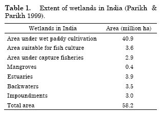
Of the estimated 58.2 million hectares of
wetlands in India, 40.9 million hectares are under
rice cultivation (Anon. 1993).
Direct deforestation in wetlands
Mangrove vegetation are flood and salt tolerant
and grow along the coasts and are valued for
fish and shellfish, livestock fodder, fuel wood,
building materials, local medicine, honey, bees
wax and for extracting chemicals for tanning
leather (Ahmad 1980). Alternative farming methods
and fisheries production has replaced many
mangrove areas and continues to pose threats.
Eighty percent of India’s 4240 km2 of mangrove
forests occur in the Sunderbans and the Andaman
and Nicobar Islands (Anon. 1991). But most of the
coastal mangroves are under severe pressure due
to the economic demand on shrimps. Important
ecosystem functions such as buffer zones against
storm surges, nursery grounds and escape cover
for commercially important fishery are lost. The
shrimp farms also caused excessive withdrawal of
freshwater and increased pollution load on water
like increased lime, organic wastes, pesticides,
chemicals and disease causing organisms. The
greatest impacts were on the people directly dependent
on the mangroves for natural materials,
fish proteins and revenue. The ability of wetlands
to trap sediments and slow water is reduced.
Hydrologic alteration
Alteration in the hydrology can change the
character, functions, values and the appearance of
wetlands. The changes in hydrology include either
the removal of water from wetlands or raising the
land-surface elevation, such that it no longer
floods. Canal dredging operations have been conducted
in India from 1800s due to which 3044 km2 of irrigated land has increased to 4550 km2 in
1990 (Anon. 1994). Initial increase in the crop productivity
has given way for reduced fertility and
salt accumulations in soil due to irrigated farming
of arid soils. India has 32,000 ha of peat-land remaining
and drainage of these lands will lead to
rapid subsidence of soil surface.
Inundation by dammed reservoirs
Presently, there are more than 1550 large reservoirs
covering more than 1.45 million ha and
more than 100000 small and medium reservoirs
covering 1.1 million ha in India (Gopal 1994). By
impounding the water, the hydrology of an area is
significantly altered and allows for harnessing
moving water as a source of energy. While the
benefits of energy are well recognized, it also alters
the ecosystem.
Chronic wetland losses
Alteration of upper watersheds
Watershed conditions influence the wetlands.
The condition of the land where precipitation falls,
collects and runs-off into the soil will influence the
character and hydrologic regime of the downstream
wetlands. When agriculture, deforestation
or overgrazing removes the water-holding capacity
of the soil then soil erosion becomes more pronounced.
Large areas of India’s watershed area are
being physically stripped of their vegetation for
human use.
Degradation of water quality
Water quality is directly proportional to human
population and its various activities. More
than 50,000 small and large lakes are polluted to
the point of being considered ‘dead’ (Chopra 1985).
The major polluting factors are sewage, industrial
pollution and agricultural runoff, which may contain
pesticides, fertilisers and herbicides.
Ground water depletion
Draining of wetlands has depleted the ground
water recharge. Recent estimate indicates that in
rural India, about 6000 villages are without a
source for drinking water due to the rapid depletion
of ground water.
Introduced species and extinction of native biota
Wetlands in India support around 2400 species
and subspecies of birds. But losses in habitat have
threatened the diversity of these ecosystems
(Mitchell & Gopal 1990). Introduction of exotic species
like water hyacinth (Eichornia crassipes) and
salvinia (Salvinia molesta) have threatened the
wetlands and clogged the waterways competing
with the native vegetation.
In a recent attempt at prioritization of wetlands
for conservation, Samant (1999) noted that
as many as 700 potential wetlands do not have any
data to prioritize. Many of these wetlands are
threatened.
Wetland management - current status
Wetlands are not delineated under any specific
administrative jurisdiction. The primary responsibility
for the management of these ecosystems is in
the hands of the Ministry of Environment and
Forests. Although some wetlands are protected
after the formulation of the Wildlife Protection
Act, the others are in grave danger of extinction.
Effective coordination between the different ministries,
energy, industry, fisheries revenue, agriculture,
transport and water resources, is essential
for the protection of these ecosystems.
Protection laws and government initiatives
Wetlands conservation in India is indirectly influenced
by an array of policy and legislative
measures (Parikh & Parikh 1999). Some of the key
legislations are given below:
- The Indian Fisheries Act - 1857
- The Indian Forest Act - 1927
- Wildlife (Protection) Act - 1972
- Water (Prevention and Control of Pollution) Act - 1974
- Territorial Water, Continental Shelf, Exclusive
Economic Zone and other Marine
Zones Act - 1976
- Water (Prevention and Control of Pollution)
Act - 1977
- Maritime Zone of India (Regulation and
fishing by foreign vessels) Act - 1980
- Forest (Conservation act) – 1980
- Environmental (Protection) Act - 1986
- Coastal Zone Regulation Notification -
1991
- Wildlife (Protection) Amendment Act -
1991
- National Conservation Strategy and Policy
Statement on Environment and Development
– 1992
- National Policy And Macro level Action
Strategy on Biodiversity-1999
India is an also signatory to the Ramsar Convention
on Wetlands and the Convention of Biological
Diversity. Apart from government regulation,
development of better monitoring methods is
needed to increase the knowledge of the physical
and biological characteristics of each wetland resources,
and to gain, from this knowledge, a better
understanding of wetland dynamics and their controlling
processes. India being one of the mega diverse
nations of the world should strive to conserve
the ecological character of these ecosystems along
with the biodiversity of the flora and fauna associated
with these ecosystems.
National wetland strategy
National wetland strategy should encompass
(i) Conservation and collaborative management,
(ii) Prevention of loss and restoration and (iii) Sustainable
management. These include:
Protection
The primary necessity today is to protect the
existing wetlands. Of the many wetlands in India
only around 68 wetlands are protected. But there
are thousands of other wetlands that are biologically
and economically important but have no legal
status.
Planning, managing and monitoring
Wetlands that come under the Protected area
network have management plans but others do not. It is important for various stakeholders along
with the local community and corporate sector to
come together for an effective management plan.
Active monitoring of these wetland systems over a
period of time is essential.
Comprehensive inventory
There has been no comprehensive inventory of
all the Indian wetlands despite the efforts by the
Ministry of Environment and Forests, Asian Wetland
Bureau and World Wide Fund for Nature.
The inventory should involve the flora, fauna, and
biodiversity along with values. It should take into
account the various stakeholders in the community
too.
Legislation
Although several laws protect wetlands there
is no special legislation pertaining specially to
these ecosystems. Environment Impact Assessment
needed for major development projects highlighting
threats to wetlands need to be formulated.
Coordinated approach
Since wetlands are common property with
multi-purpose utility, their protection and management
also need to be a common responsibility.
An appropriate forum for resolving the conflict on
wetland issues has to be set up. It is important for
the ministries to allocate sufficient funds towards
the conservation of these ecosystems.
Research
There is a necessity for research in the formulation
of national strategy to understand the dynamics
of these ecosystems. This could be useful
for the planners to formulate strategies for the
mitigation of pollution. The scientific knowledge
will help the planners in understanding the economic
values and benefits, which in turn will help
in setting priorities and focusing the planning
process.
Building awareness
For achieving any sustainable success in the
protection of these wetlands, awareness among the
general public, educational and corporate institutions
must be created. The policy makers, at various
levels along with site managers need to be
educated. As the country’s wetlands are shared,
the bi-lateral cooperation in the resource management
needs to be enhanced.
Use of remote sensing and GIS in
wetland management
Remote sensing data in combination with Geographic
Information System (GIS) are effective
tools for wetland conservation and management.
The application encompasses water resource assessment,
hydrologic modeling, flood management,
reservoir capacity surveys, assessment and monitoring
of the environmental impacts of water resources
project and water quality mapping and
monitoring (Jonna 1999).
Flood zonation mapping
Satellite data are used for interpretation and
delineation of flood-inundated regions, flood-risk
zones. Temporal data helps us to obtain correct
ground information about the status of ongoing
conservation projects. IRS 1C/D WIFS data having
180 km spatial resolution and high temporal repetitiveness
has helped in delineating the zonation
of flooding areas of large river bodies, thus helping
in the preparation of state-wise and basin wise
flood inventories.
Inventory and monitoring of irrigation and
cropping pattern
Remote-sensing data paves way for economic
methodology for inventorying, monitoring and
management of water bodies due to improving spatial,
spectral and temporal resolution. Satellite
data in association with the geographical information
systems provides a cost and time-effective tool
for identification, mapping, inventorying and
monitoring of cropping pattern, crop production
and condition, monitoring irrigation status and in
the diagnosis of poorly performing irrigation patterns.
Indian IRS-1A and 1B satellites data has
been used for inventorying irrigation systems,
cropping pattern, water logging, tank irrigation,
watershed delineation, silting during post monsoon,
temporal changes in the water-spread and
irrigated area. These inventorying data are used
as inputs for formulation of conservation and
management plans for development of land and
water resources.
Water quality analysis and modeling
Remote sensing data is used for the analysis of
water quality parameters and modeling. Water quality studies have been done carried out using
the relationship between reflectance, suspended
solid concentration, and chlorophyll-a concentration.
In the near infrared wavelength range, the
amount of suspended solids content is directly proportional
to the reflectance. Due to spatial and
temporal resolution of satellite data information of
the source of pollution and the point of discharge,
inflow of sewage can be regularly monitored.
Using IRS LISS II data (Sasmal & Raju 1996)
monitored the suspended load in estuarine waters
of Hoogly, West Bengal in a GIS environment. In
this study band 4 of the data set was found to
show a wider range of digital classes indicating a
better response with depth than rest of the bands.
Landsat TM and IRS –1A data were used to estimate
sediment load in Upper lake, Bhopal (Raju
et al. 1993). This study showed high relationship
between the satellite as well as ground truth radiometric
data and total suspended solids. Different
image processing algorithms are also used on
Landsat MSS dataset to delineate sediment concentration
in reservoirs (Jonna et al. 1989). Qualitative
remote sensing methods have been used for
real time monitoring of Inland Water quality
(Gitelson et al. 1993) Airborne sensor has also been
used to study the primary productivity and related
parameters of coastal waters and large water bodies
(Seshmani et al. 1994).
Mapping changes in the river course
Hazra & Bhattacharya (1999) studied the
changes in the river course of Ganga - Padma
River over space and time to delineate the vulnerable
zones for environment management, using
visual interpretation techniques to identify and
delineate various geomorphological and geological
features. The results indicate the river will shift
along its course due to natural calamity and in
some places due to anthropogenic interferences.
Delineation of extinct river course
Because of its sensitivity to moisture and
penetration capabilities in arid regions, satellite
remote sensing also helps in displaying anomalies
in the terrain that are caused due to the pattern of
vegetation/water bodies, sand-dunes, lithology,
drainage courses, salt lakes, topography and
slopes, natural breaks etc. which help in creating a
conceptualized model of the extinct river-course.
Hence it proves an effective tool for the study of
the course of ancient Saraswati (Sharma et al.
1999) more than any other method.
Water resource management
GIS and remote sensing was used for the development
of water resources in Sai-Gad subwatershed
of Almora District, Uttar Pradesh
(Mohan et al. 2000). Various thematic maps on the
hydro-geomorphological characteristics, elevation,
slope, drainage, surface water bodies and land-use
have been generated and integrated for the action
plan for Water Resources Development.
For the evaluation of hydro-geochemical conditions
of Niva river basin, Chittoor district in Andhra
Pradesh drainage maps of the basin were
prepared and the imagery data were interpreted
using standard interpretation keys such as colour,
tone, texture and pattern of drainage, shape and
topography. The results revealed that the underground
potential of the basin is moderate to good
(Rao 1997).
The drainage pattern of Jharia coalfield, Bihar,
India as observed on IRS-1A LISS II image
shows that the region is drained by 11 streams,
which eventually drain into river Damodar
(Srivastava 1997). It is thus helpful in conducting
environmental impact assessment.
Use of satellite remote sensing data coupled
with aerial photo-interpretation greatly aid in
planning ground water exploration and help in
locating the sources by identification of geomorphological
units. Air-borne and space-borne data
were used for the qualitative evaluation of ground
water resources in Keonjhar district, Orissa (Das
et al. 1997). The study revealed the importance of
hydrogeomorphological mapping from remotely
sensed data in groundwater targeting in the structurally
complex terrain of the district. Resistivity
soundings and exploratory digging further corroborated
the study.
Remote sensing, geophysical, DBTM (Digital
Basement Terrain Model) and GIS (Geographic
Information System) were used for sustainable
utilisation of water resources of Alaunja watershed,
located in ‘Chotanagpur’ plateau of Bihar
(Kumar 1999). The study helped in the prioritization
of water resource development in the watershed
i.e., delineation of the area suitable for
groundwater/surface water utilisation.
With the development of highly precise remote
sensing techniques in spatial resolution and GIS, the modeling of watershed has become more physically
based and distributed to enumerate interactive
hydrological processes considering spatial heterogeneity.
A distributed model with SCS curve
number method called as Land Use Change (LUC)
model was developed (Mohan & Shresta 2000) to
assess the hydrological changes due to land use
modification. The model developed was applied to
Bagmati river catchment in Kathmandu valley
basin, Nepal. The study clearly demonstrated that
integration of remote sensing, GIS and spatially
distributed model provides a powerful tool for assessment
of the hydrological changes due to landuse
modifications.
Habitat mapping using microwave
remote sensing
Microwave remote sensing tools have an important
role to play in applications relating to wetland
monitoring and mapping. In optical remote
sensing, the visible and infrared part of the electromagnetic
spectrum is made use of to characterize
objects of interest. However, during monsoon
season, the suitable atmospheric windows for acquisition
of optical data are limited to cloud free
period. This is a major lacuna for wetland applications
as wetlands are highly seasonal and dynamic
systems compared to terrestrial ecosystems. The
radar imaging system overcome many of these
limitations by providing increased canopy penetrations
and day and night acquisitions nearly independent
of weather conditions (Ramsey 1995;
Ramsey & Laine 1997). It is, therefore, imperative
to use radar data for a better understanding of the
dynamics of wetland ecosystems as also their assessment,
monitoring and management. There are
also several advantages using microwave data.
Microwave sensors have unique sensitivity towards
the moisture content of earth material.
They are also highly sensitive to textural properties
of vegetative cover. Therefore, they can be
used to discriminate grasses, aquatic vegetation,
forest and crop cover. In this way the surrounding
people can use them to identify the encroachment
inside a national park for agricultural activities.
Identification of different habitat is also an
important activity for wetland monitoring and
management. Studies indicate that Synthetic aperture
Radar data is far superior to optical satellite
data in delineation of open water, habitat and
aquatic vegetation. Though radar remote sensing
can play an important role in wetlands but so far
very little work has been carried out and there is
huge potential to explore and exploit the different
capabilities of radar data for wetland research.
High incidence angle radar data has been used to
delineate the open water habitat with aquatic
vegetation critical for waterfowl in wetlands The
study of Keoladeo Ghana National park in
Bharatpur has shown that radar data is 3 to 4
times better in delineating extent of open water,
aquatic vegetation categories and also localities of
high soil moisture content (Srivastava et al. 2001).
This information will be of great significance in
formulating Habitat Suitability Index (HSI) models
for a variety of faunal species.
The interconnectivity of wetlands
The interconnectivity of wetlands and changes
in it over a period of time were documented for
large areas of Bangalore urban and rural districts
by Deepa & Ramachandra (1999). From a landscape
perspective, it is vital that studies on interconnectivity
are given emphasis. The results are of
crucial significance in designing conservation preserves
of wetlands.
Wetland mapping – a status review
Wetlands play a vital role in maintaining the
overall cultural, economic and ecological health of
the ecosystem, their fast pace of disappearance
from the landscape is of great concern. The Wildlife
Protection Act protects few of the ecologically
sensitive regions whereas several wetlands are
becoming an easy target for anthropogenic exploitation.
Survey of 147 major sites across various
agro climatic zones identified the anthropogenic
interference as the main cause of wetland degradation
(The Directory of Indian Wetlands 1993).
Current spatial spread of wetlands under various
categories is shown. (Table 1) (Parikh & Parikh
1999).
The National wetland committee of the Ministry
of Environment and Forests (MoEnF), Govt. of
India has recommended a number of proactive
steps. Accordingly, twenty-two sites were declared
tentatively as wetlands of National and International
significance for long term conservation. The
committee recommended a nation wide inventory
of wetlands to be undertaken under the guidance
of National wetland committee with the support of the Standing Committee on Bioresources (SC-B) of
the National Natural Resource Management system
(NNRMS) and MoEF. The Space Application
Center (SAC) Ahmedabad, of the Indian Space Research
Organization (ISRO) had undertaken, in
collaboration with various state remote sensing
application centers, a nation wide mapping of
Inland wetlands. This was done on a reconnaissance
scale and was completed in 1997. The study
recommended mapping at larger spatial scale as
wetlands below 56 ha in size could not be delineated.
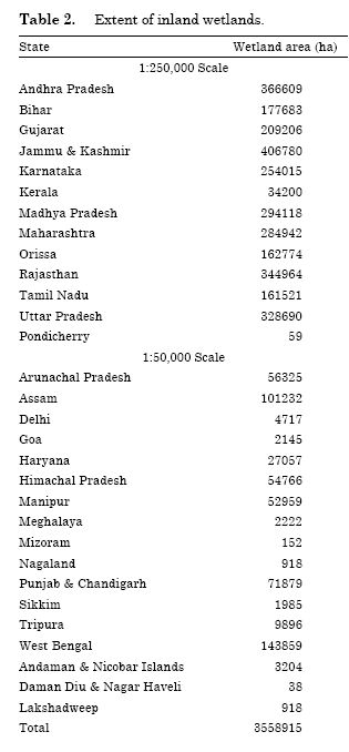
The Space Application Center (SAC) has
mapped the wetlands at 1:250000 scale in the
mainland as well the islands using the visual interpretation
of coarse resolution satellite data. The
states of Sikkim, West Bengal, Goa Punjab, Haryana,
Himachal Pradesh, Chandigarh, Delhi, Andaman,
Nicobar, Lakshwadeep, Dadra and Nagerhaveli
were mapped at 1:50000 scale. However, in
the rest of the country, only wetlands of 56.25 ha
and above in size could be mapped (Table 2). It is
known that a vast majority of wetlands-often in
number, extent and conservation importance is
below 50 ha in size (For example, those in the
Indo-gangetic plains and in the Deccan peninsula).
Thus, the inventory covered only a small number
of wetlands: more over, the conservation values
are not known for those wetlands even whose inventory
has now been obtained. The data merely
indicates location of wetlands, the classification of
wetlands on 1:250,000 scale is moreover, only geomorphologic
in nature (such as Oxbow lakes,
Playas, Lakes and Ponds etc.) and has no other
factual biological conservation value. By itself, the
information will only be partly useful for conservation
of wetlands. This estimate is likely to be twice
if we include wetlands of size 50 ha or less (Das et
al. 1994 for Etwah and Mainpuri districts of U.P.).
Requirement and information needs
for wetland mapping
Past research on wetland conservation in the
country has shown conclusively that micro wetlands or satellite wetlands around a bigger wetland
act as a constellation of habitat mosaic for
resident and migratory waterfowl (Vijayan 1991).
This is of special importance for inland wetland
habitats in the flyways of migratory birds in the
Indo-Gangetic plains and in Deccan peninsula.
Often, the size of these micro wetlands is much
smaller than 50 ha. Therefore, there is a great
need to map wetlands of size smaller than 50 ha.
Thus, the objective is to develop an inland wetland
inventory for the entire country. This will be
carried out by means of available data and by also
fresh data generation using modern spatial technologies.
Thus by using digital remote sensing
data for wetland mapping and analysis, information
at any scale of all Wetlands will be available
according to the management and conservation
requirements. Realizing the importance of wetlands,
the Ramsar convention in 1971 has urged
the member countries to designate noted wetlands
as Ramsar sites or wetlands of International Significance.
Many conservationists (e.g. Choudhury 2000)
have recognized this and a wetland conservation
strategy should therefore have an extensive bias of
participatory process. A hierarchical watershed
based approach will have a positive impact in not
only reversing the chronic cases of wetland resource
depletion but also help design a network of
wetland conservation preserves. These preserves
would strive to not only conserve precious aquatic
biodiversity but also help serve as refuge for important
economically useful wild plants and animal
genetic resources.
Ongoing programme of wetland conservation
It is with this goal, the programme aims at developing:
- a user friendly and cost effective process of
wetland mapping from a biodiversity conservation
perspective.
- an inland wetland information system encompassing
inter alia socioeconomic data on wetlands
and ecological, ornithological and other biodiversity
values and
- establishment of a basis and framework for
effective national, regional and sub-regional monitoring
of wetlands using satellite data and other
spatial information as well as ancillary data.
The programme output is expected to aid in
evolving a National Inland Wetland Conservation
Strategy. The strategy includes policy, administrative
and monitoring measures.
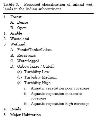
Classification scheme of inland wetlands
Classification scheme proposed by Gopal
(1994) on Inland wetlands in the Indian subcontinent
is a mix of hydrological and biological
(aquatic plants diversity) factors. However, from a
practical conservation planning perspective, the
immediate need of the hour is to produce a reasonably
detailed classification based on a mix of
habitats and aquatic vegetation. The merits of
such a classification lies mainly in its utility to be
used by both managers and academicians. Such a
scheme is possible with extensive state of art spatial
technologies and a carefully chosen field information
and data. The current sensor resolution
of course would permit aquatic vegetation classification
at species assemblages level, if not at species
level. However, for the reasons of wider usage
and lower costs, it is nevertheless possible to use
the 20 m resolution sensors of IRS series of Indian
remote sensing satellites. Hence the modified classification
system (Table 3) should be adopted for
classification of inland wetlands using remote
sensing data.
A proposed methodology
For classification of Inland wetlands using remote
sensing techniques, Band 4 of IRS 1C LISS
III image data is to be density sliced for the separation
of water bodies. The threshold values for
water mask are to be obtained interactively. A bit
map is to be generated for the water bodies. This
mask will be used for further classification of water
bodies into turbidity pattern and aquatic vegetation.
Although, the density slicing of band 4 provides
acceptable results in most of the cases, it
may sometime, lead to confusions with non-water
classes. Major class of confusion is the shadow due
to terrain. Such anomalies can be removed
through stratified density slicing and through contextual
refinements.
Normalized Difference Vegetation Index
(NDVI) that minimizes effect of the shadow can
also be used for separation of water bodies, as the
wetland areas fall in lower NDVI zone, than terrestrial
vegetation. However, NDVI may also exhibit
confusing results as many other nonvegetated
classes like snow, barren, land etc. may
exhibit the NDVI values comparable to water
body. However, an interactive integration of
band 4 and NDVI will clearly separate water bodies.
Turbidity patterns
Turbidity patterns are best reflected by the
band 1of IRS 1C, LISS III image data. Higher the
DN value in band 1, higher is the turbidity. The
turbidity classification is a subjective one as it is
impractical to relate the quantitative values for
turbidity (which are dynamic according to the season)
with the reflectance. Thus, determination of
the threshold for different turbidity levels needs to
be carried out by examining the major (large sized)
water bodies in the area.
Aquatic vegetation
Aquatic vegetation need to be classified
within the water body mask that is generated
using band 4 of IRS LISS III data. The Normalised
Differential Vegetation Index (NDVI) {generated
as: (IR-)/(IR+R) where, IR is DN value in
Band 3 and R is DN value in band 2 of IRS 1C
LISS III is to be obtained for water bodies. The
NDVI values are subjectively divided into vegetation
levels i.e. nil, poor, moderate and high vegetation
coverage.
After country wide mapping of inland wetlands,
some selected wetlands of each state which
are prioritized due to their biodiversity values are
to be considered for detail mapping on 1:50,000
scale.
Conclusion
It is noteworthy that even a small country
like UK could designate 161 wetlands as Ramsar
sites, India being a mega-diversity country, so far
managed to delineate a mere six sites till date.
There is obviously much ground to be covered in
our conservation efforts of wetlands. In addition,
a paradigm shift in conservation ethic is also a
strong need of the hour. This shift is necessary
and perhaps mandatory due to the very nature of
resource being conserved and ‘protected’. Since
wetlands are a common property resource, it is an
uphill task to protect or conserve the ecosystems
unless; the principal stakeholders are involved in
the process. The dynamic nature of wetlands necessitates
the widespread and consistent use of
satellite based remote sensors and low cost, affordable
GIS tools for effective management and
monitoring.
Acknowledgements
Financial support from UNDP, New Delhi and
MoEn&F Govt. of India is gratefully acknowledged.
T.V. Ramachandra and N. Ahalya also acknowledges
the financial assistance from the Indian
Institute of Science. Thanks are due to Dr.
M.L. Manchanda, Head, RRSSC-D and Shri S.
Adiga, Director, NNRMS, Department of Space, for
RRSSC facilities. We also thank Dr. P.S. Roy,
Dean, IIRS, Dehradun for evinsing keen interest
in this study. T.V. Ramachandra is greatful to
Prof. N.V. Joshi, Prof. Sukumar, Prof. Devashish
Kar, Prof. Rajasekara Murthy, Dr. M.B. Krishna
and Dr. B.K. Chakrapani for useful suggestions,
Mr. Joshua D. David, Mr. Rajini Kanth, Mr. Kiran
Rajashekariah, Ms. Ranjani V.G., Ms. Deepa and
Mr. Reddy M.S. for their support in data compilation,
field investigation and laboratory analysis
and manuscript preparation. Thanks are due to
Bilal Habib for reviewing the manuscript at its
final stage of publication.
References
- Ahmad, N. 1980. Some aspects of economic resources of
Sunderbans mangrove forests of Bangladesh. pp. 50-
51. In: P. Soepadmo (ed.) Mangrove Environment:
Research and Management. Report on UNESCO
Asian Symposium, held at University of Malaya,
Kuala Lumpur, Malaysia, 25-29 August 1980.
- Anonymous, 1991. India 1990. A Refrence Annual. Research
and Reference Division, Ministry of Information
and Broadcasting, Govt. of India, Delhi.
- Anonymous, 1993. Directory of Indian Wetlands. World
Wildlife Federation, New Delhi
- Anonymous, 1994. World Development Report. World
Bank Development Report.
- Chopra, R. 1985. The State of India’s Environment. Ambassador
Press, New Delhi.
- Choudhury, B.C. 2000. Conserving wetlands: emerging
scenario. pp. 131-138. In: A. Bhardwaj, R. Badola &
B. M. Rathore (eds.) Proceedings of the workshop on
the ‘Conserving Biodiversity in the 21st Century,
through Integrated Conservation and Development
Planning on a Regional Scale’. LBSNA Mussorie
and WII Dehradun.
- Das, S., S.C. Behera., A. Kar., P. Narendra & S. Guha.
1997. Hydrogeomorphological mapping in ground
water exploration using remotely sensed data – A
case study in Keonjhar District, Orissa. Journal of
the Indian Society of Remote Sensing 25: 247-250.
- Das, K.K., S.N. Prasad., P.S. Roy & S.K. Bhan. 1994.
Mapping of Potential Crane Habitat in Etawah and
Mainpuri Districts (U.P.) using Satellite Remote
Sensing Techniques. A Project Report: Indian Institute
of Remote Sensing, Dehradun and Salim Ali
Centre for Ornithology and Natural History,
Kalampalayam, Coimbatore.
- Deepa, R.S., & T.V. Ramachandra. 1999. Impact of Urbanization
in the Interconnectivity of Wetlands. Paper
presented at the National Symposium on Remote
Sensing Applications for Natural Resources:
Retrospective and Perspective (XIX-XXI 1999), Indian
Society of Remote Sensing, Banglore.
- Foote Lee, S., Pandey & N.T. Krogman. 1996. Processes
of wetland loss in India. Environmental Conservation
23: 45-54.
- Gitelson, A., G. Garbuzov., F. Szilagyi., K.H. Mittenzwey.,
A. Karnielli & A. Kaiser. 1993. Quantitative
remote sensing methods for real-time monitoring
of inland water quality. International Journal of
Remote Sensing 14: 1269-1295.
- Gopal, B. 1994. Conservation of inland waters in India:
an overview. Verhandlungen der Internationalen
Vereinigung fur Theorestische und Angewandie Limnologie
25: 2492-2497.
- Gopal, B. 1995. Biodiversity in Freshwater Ecosystems
Including Wetlands, Biodiversity and Conservation
in India, A Status Report. Vol. 4, Zoological Survey
of India, Calcutta.
- Gosselink, J.G. & R.E. Turner. 1978. The role of hydrology
in fresh water wetland ecosystems. pp. 63-
78. In: R.E. Good, D.F. Whigham & R.L. Simpson
(eds.) Freshwater Wetlands: Ecological Processes
and Management Potential. Academic Press, New
York.
- Groombridge, B. & M. Jenkin. 1998. Freshwater Biodiversity:
A Preliminary Global Assessment, WCMC.
Biodiversity Series No.8, World Conservation
Press.
- Hazra, P.B. & B. Bhattacharya. 1999. River shifting and
bank failure problem of Ganga- Padma in West
Bengal. pp. 385-390. In: S. Adiga (ed.). Retrospective
and Perspective. Proceedings of ISRS National
Symposium on Remote Sensing Applications for
Natural Resources. Dehradun.
- Jonna, S. 1999. Remote sensing applications to water
resources: retrospective and Perspective. pp. 368-
377. In: S. Adiga (ed.). Proceedings of ISRS National
Symposium on Remote Sensing Applications for
Natural Resources. Dehradun.
- Jonna, S., K.V.S. Badarinath & J. Saibaba. 1989. Digital
image processing of remote sensing data for water
quality studies. Journal of the Indian Society of Remote
Sensing 17: 59-64.
- Kar Devashish., A.V. Nagarathna & T.V. Ramachandra.
2000. Fish diversity and conservation aspects in an
aquatic ecosystem in India. INTECOL, 6th International
Wetland Symposium, August VI -XII, 2000,
Quebec, Canada. Organized by International Association
of Ecology (http://www.cqvb.qc.ca/wetland2000/)
and Society of Wetland Scientists (http://
www.sws.org/intecol/abstracts_program/index.html).
- Kumar, A. 1999. Sustainable utilisation of water resource
in watershed perspective – a case study in
Alaunja watershed, Hazaribagh, Bihar. Journal of
the Indian Society of Remote Sensing 27: 13-22.
- Mitchell, S. & B. Gopal. 1990. Invasion of tropical
freshwater by alien species. pp. 139-154. In: P. S.
Ramakrishnan (ed.) Ecology of Biological Invasion
in the Tropics.
- Mitsch, W.I. & I.G. Gosselink. 1986. Wetlands. Van
Nostrand Reinhold, New York.
- Mohan, S. & M.N. Shrestha. 2000. A GIS based integrated
model for assessment of hydrological changes
due to land-use modifications. pp. 27-29. In: T.V.
Ramchandra (ed.) Symposium on Restoration of
Lakes and Wetlands, November 2000, Indian Institute
of Sciences, Bangalore.
- Parikh, J. & K. Parikh. 1999. Sustainable Wetland. Environmental
Governance – 2, Indira Gandhi Institute
of Development Research, Mumbai.
- Raju, P.L.N., A.K. Chakraborti & C.V. Deshpande.
1993. Estimation of suspended sediment load upper
lake, Bhopal using remote sensing techniques.
pp. 25-27. In: B. Sahai, D.C. Goswami,
A.K. Rai, N.D. Sharma, K.V. Ravindran & P.K.
Sharma (eds.). Proceedings National Symposium
on Remote Sensing Applications for Resource
Management with Special Emphasis on N. E. Region,
Guwahati.
- Ramsey III, E.W. & S.C. Laine. 1997. Comparison of
landsat thematic mapper and high-resolution
photography to identify change in complex coastal
wetlands. Journal of Coastal Wetlands 13: 281-
292.
- Ramsey III, E.W. 1995. Monitoring flooding in coastal
wetlands by using radar imagery and ground-based
measurements. International Journal of Remote
Sensing 16: 2495-2502.
- Rao, H.V.N. 1997. Restoration of Ulsoor lake, Bangalore.
pp. 20-24. In: Proceedings of One – Day Workshop on
Lakes for Bangalore Water Needs – Beautification
and Pollution Prevention, Environment Association
of Bangalore.
- Samant, S. 1999. Prioritization of biological conservation
sites in India wetland. pp. 155-167. In: Shekhar
Singh, A.R.K. Sastry, Raman Mehta & Vishaish
Uppal (eds.). Setting Biodiversity Conservation
Priorities for India. World Wide Fund for Nature,
India.
- Sasmal, S.K. & P.L.N. Raju. 1996. Monitoring suspended
load in estuarine waters of Hooghly with
satellite data using PC based GIS environment. In:
Proceedings of National Symposium on Coastal Zone
Management. Feb. 25-26 Behrampur University,
Behrampur, Orissa.
- Seshamani, R., T.K. Alex & Y.K. Jain. 1994. An airborne
sensor for primary productivity and related
parameters of coastal waters and large water bodies.
International Journal of Remote Sensing 15:
1101-1108.
- Sharma, J.R., A.K. Gupta., S. Pathak., A.S. Rajawat.,
D.C. Sharma, K.S. Srivastava & V. Soni. 1999. Results
of the remote sensing based studies on reconstruction
of the course of river Saraswati in western
India. pp. 378-384. In: Proceedings of ISRS National
Symposium on Remote Sensing Applications for
Natural Resources- Retrospective and Perspective.
- Srivastava, H.S., S.N. Prasad., M.L. Manchanda & S.
Adiga. 2001. Radar remote sensing applications in
wetland habitats - a case study with multi-incidence
angle radarsat SAR data. pp. 87-92. In: I.V. Muralikrishan
(eds) Spatial Information Technology
Remote Sensing and GIS. Vol 2. B.S. Publications,
Hyderabad.
- Srivastava, V.K. 1997. Study of the drainage pattern of
the Jharia coalfield (Bihar) India, through remote
sensing technology. Journal of the Indian Society of
Remote Sensing 25: 41-46.
- Vijayan, V.S. 1991. Keoladeo National Park Ecology
Study. Final Report. Bombay Natural History Society.
|