 |
Conservation of Wetlands for Ensuring Regional Water Security
| 
|
| T.V. Ramachandra |
Co-ordinator, Energy & Wetlands Research Group, Center for Ecological Sciences [CES],
Centre for Sustainable Technologies (astra)],
Centre for infrastructure, Sustainable Transportation and Urban Planning [CiSTUP],
Indian Institute of Science, Bengaluru,
Karnataka, 560 012, India
Web URL: http://ces.iisc.ac.in/energy; http://ces.iisc.ac.in/foss,
Email: cestvr@ces.iisc.ac.in; energy@ces.iisc.ac.in,
Tel: 91-080-22933099, 2293 3503 extn 101, 107, 113
|
|
Water is one of the fundamental elements of the universe from which early life originated millions of years ago on earth. Every life on the earth is primarily dependent on water which hosts innumerable aquatic species from single cell creatures to gigantic blue whales. As the evolution of human took place, civilized human settled down on the fertile river banks. In other words, river banks are the motherhood for civilized human and most of the civilization around the world. These river or lake banks gave water for drinking and also for cropping along with mineral rich soil. Civilized men knew the importance of water and respected these water bodies. Advantages of traditional water harvesting structures are:
- Water made to stand for a period so as to allow infiltration / percolation and recharging of groundwater aquifers to sustain good water levels in the surrounding wells;
- a saturated sub soil/top soil, enhances the green cover in the surroundings;
- green cover in the catchment reduces soil erosion and hence sedimentation of rivers; and
- mitigation of instances of frequent floods and runoff.
Deterioration of traditional water harvesting practices in other parts of burgeoning Bangalore has resulted in the inequity in water distribution and growing water scarcity, which has escalated water conflicts during the 20th century. Irresponsible management of natural resources is evident from (i) sustained inflow of untreated sewage and industrial effluents; (ii) dumping of solid waste (with 70% being organic); (iii) transport of untreated wastewater in storm water drains (water drains are essentially arteries of a landscape carrying water), etc.
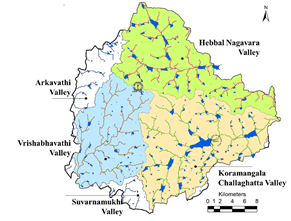
Bangalore being located on the ridge, forms three watersheds as precipitation flows as runoff in three directions along the valleys (Figure 2) - Koramangala Challaghatta Valley (K&C Valley), Hebbal Valley (H Valley) and the Vrishabhavati Valley (V Valley). Under the administrative boundary of Bruhat Bengaluru, K&C valley is the largest encompassing an area of 255 square kilometers, followed by Hebbal valley with an area of 207 square kilometers and Vrishabhavati valley with an area of 165 square kilometers. Both K&C valley and Hebbal valley joins at Nagondanahalli village (BBMP Ward 94 – Hagadur) which further flow to Dakshina Pinakini River, where as Vrishabhavati valley joins Arkavathi river which is a tributary of river Cauvery.

Figure 1: River and wetlands – Drainage Network along the Major valleys
Number of wetlands in Bangalore has reduced from nearly 285 (spatial extent of Bangalore: 161 sq.km. in early seventies) to 194 (spatial extent of Bangalore: 741 sq.km. in 2006). Unplanned rapid urbanisation during late nineties, witnessed large-scale unrealistic, uncontrolled developmental activities in the neighborhood of wetlands. Land use analysis in Bangalore City shows 1005% increase in urban (built-up) area between 1973 and 2016 i.e., from 8.0% (in 1973) to 77% (in 2016). Land use prediction using Agent Based Model showed that built up area would increase to 93.3% by 2020, and the landscape is almost at the verge of saturation.
Average annual rainfall in Bangalore is 787 mm with 75% dependability and return period of 5 years. Catchment wise water yield analysis indicates that about 49.5% (7.32 TMC) in the Vrishabhavathi valley (including Arkavathi and Suvarnamukhi), followed by 35.2% (5.2 TMC) in Koramangala Challaghatta valley and 15.3% (4.2 TMC) in Hebbal Valley and the total annual water yield is about 14.80 TMC. Domestic demand of water (at 150 lpcd) is 20.05 TMC per year (1573 MLD). This means about 73% of Bangalore’s water demand can be met by efficient harvesting of rain water. Quantification of sewage generated shows that about 16.04 TMC (1258 MLD) of sewage is generated in the city.
Sewage treatment with complete removal of nutrients and chemical contaminants by adopting decentralized treatment plants similar to the success model (secondary treatment plant integrated with constructed wetlands and algae pond) at Jakkur lake. In addition to this, water available with efficient rainwater harvesting is about 14.8 TMC. This means that total of 30.85 TMC of water is available annually to cater the demand of 20.05 TMC, provided the city administration opts for decentralized optimal water management through (i) rainwater harvesting by rejuvenating lakes. The best option to harvest rain water is through interconnected lake systems, (ii) treatment of sewage generated in households in each locality (opting the model at Jakkur lake – STP (Sewage Treatment Plant) integrated with constructed wetlands and algal pond; (iii) conservation of water by plugging the pilferages (due to faulty distribution system); (iv) ensuring water supply 24x7 and (v) ensuring all sections of the society get equal quantity and quality of water. Rejuvenating lakes in the region helps in retaining the rain water. Treating sewage and options to recycle and reuse would minimize the demand for water from outside the region. The analysis illustrates that the city has at least 30 TMC (Bangalore city) of water, which is higher than the existing demand (20.08 TMC, at 150 lpcd and 2016 population), if the city adopts 5R’s (Retain, Rejuvenate, Recycle, Reuse, Retain and Responsible citizens). In order to enhance the water retaining capability in the catchment, it is essential to harvest rain water and undertake large scale watershed programme (soil and water conservation). Lakes are the optimal means of rainwater harvesting at community level. This entails
- Reestablishing interconnectivity among lakes (needs to remove all encroachments without any consideration, as the water security of a region is vital than the vested interests, who have unauthorisedly occupied without respecting future generation’s food and water security. This would also reduce the frequency of floods and consequent damage to life and property,
- removal of all encroachments of lakes and lake bed,
- rejuvenation and regular maintenance of water bodies - this involves desilting of lakes to (a) enhance the storage capacity to retain rainwater, (b) increase the recharge potential – will improve groundwater table, (c) ensure recharging without any contamination,
- allowing only treated sewage (removal of chemical and biological contaminants) through adoption of integrated wetlands ecosystem (Jakkur lake model),
- creation of wetlands with native vegetation and regular harvesting of macrophytes; food and fodder, which supports local people’s livelihood, and
- maintaining at least 33% green cover with native vegetation (grass, trees, shrubs)in the catchment and planting riparian vegetation in the buffer region. This would help infiltration of water and retain this water.
Reference: https://www.researchgate.net/publication/308970543_WATER_SITUATION_IN_BENGALURU
|
Dr. T.V. Ramachandra
Centre for Sustainable Technologies, Centre for infrastructure, Sustainable Transportation and Urban Planning (CiSTUP), Energy & Wetlands Research Group, Centre for Ecological Sciences, Indian Institute of Science, Bangalore – 560 012, INDIA.
E-mail : cestvr@ces.iisc.ac.in
Tel: 91-080-22933099/23600985,
Fax: 91-080-23601428/23600085
Web: http://ces.iisc.ac.in/energy
Citation: Ramachandra T.V., 2017. Conservation of Wetlands for Wnsuring Regional Water Security, The Environment Management, Vol. III, Issue I, Jan – Mar, 2017, pp. 1-3.
| Contact Address : |
| |
Dr. T.V. Ramachandra
Energy & Wetlands Research Group,
Centre for Ecological Sciences, TE 15, New Biology Building, Third Floor, E Wing, [Near D Gate], Indian Institute of Science, Bangalore – 560 012, INDIA.
Tel : 91-80-22933099 / 22933503-extn 107
Fax : 91-80-23601428 / 23600085 / 23600683 [CES-TVR]
E-mail : cestvr@ces.iisc.ac.in, energy@ces.iisc.ac.in,
Web : http://wgbis.ces.iisc.ac.in/energy |
| |