3. STUDY AREA |
3. STUDY AREA |
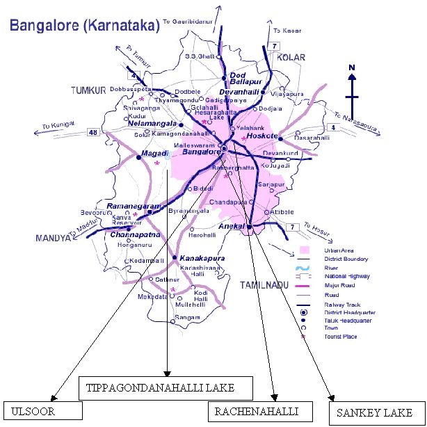
Bangalore district is located in the heart of South Deccan of Peninsular India. It is situated in the southeastern corner of Karnataka state (12039' 13018' N latitude and 77022' 77052' E longitude) with a geographical area of about 2,191 sq.km and an average elevation of 900 m above sea level. The climate of the district enjoys an agreeable temperature range from the highest mean maximum of 330C in April to lowest mean maximum of 140C in January. It has two rainy seasons from June to September and October to November coming one after the other but with opposite wind regime, corresponding to south-west and north-east monsoons. The mean monthly relative humidity is lowest in the month of March (44%) and high during the month of June to October, being between 80 to 85% on an average. The mean annual rainfall is 859.6 mm and the mean number of rainy days is about 57. Bangalore receives 54% of the total rainfall in the Southwest monsoon period with a rainfall of 496 mm and 34 rainy days whereas the Northeast monsoon contributes a mean rainfall of 241 mm and means rainy days being 14 (Kamath, 1990). The location of Bangalore district is shown in figure 4.
Bangalore city once sported a large number of lakes, ponds and marshy wetlands, which ensured a high level of ground water table and pleasant climate. It is a great pity that many of the lakes and ponds have already disappeared due to various anthropogenic activities and pressures due to unplanned urbanization and expansion. Surviving lakes are reduced to cesspools due to direct discharge of industrial effluents, sewage and unregulated dumping of solid wastes.
Figure 4: The location of Bangalore district.
Lakes of Bangalore occupy about 4.8% of city's geographical area (640 sq.km) covering both urban and rural areas (Krishna et al ., 1996). Bangalore has many man-made lakes but no natural lakes. They were built for various hydrological purposes and to serve the needs of drinking water and irrigation. Totally there were 262 lakes coming within the green belt area of Bangalore city. The table below gives the distribution of tanks in Bangalore district (Chakrapani, 1996).
S. No. |
Name of the Taluk |
Number of lakes |
1 |
Bangalore North | 61 |
2 |
Bangalore South | 98 |
3 |
Hoskote | 23 |
4 |
Anekal | 44 |
5 |
Magadi | 11 |
6 |
Nelamangala | 13 |
7 |
Devanahalli | 12 |
The number of lakes in Bangalore has fallen from 262 in 1960 to 81 at present (Lakshman Rau, 1986). Four lakes were selected based on use values for the study. The exact location of the selected lakes is given figure 5.
Figure 5: The location of selected lakes in Bangalore district.
The location of each lake with its catchment details and status has been described in the following section. The selection of sampling points is important because the sampling at one part of the lake doesnot reveal the status of the entire water body. The sampling points in each lake are given in figures 6 to 9.
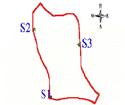
The Sankey lake was constructed in the 19 th century by Col. Sankey in the western part of the city, between Malleswaram and Sadashiv nagar areas, to meet the drinking water demand. It is spread over an area of 10 hectares. The lake has a well-maintained park and a corporation swimming pool at the southern part and nursery towards the north, adjacent to the tank. The water presently used for watering the plants surrounding the lake. The tank reserves the recreational requirement of the region and has boat club run by the Karnataka State Tourism Development Corporation (KSTDC). Figure 6 gives the boundary and the sampling points in the lake
Figure 6: Location of sampling points in Sankey lake.
Scale 1: 50,000.
S1 Sampling point 1 N (13 0 00' 29.3'' E 77 0 34' 21.4'' - Outlet and small inlet).
S2 Sampling point 2 N (13 0 00' 41.1'' E 77 0 34' 22.7'' - Near bridge).
S3 Sampling point 3 N (13 0 00' 36.4'' E 77 0 34' 30.2'' - Near entrance, Sadashivnagar).
RACHENAHALLI LAKERachenahalli lake is situated in Bangalore north taluk and has area of about 60 hectares. The water of the lake is mainly used for agricultural and washing purposes of surrounding area. The tank is almost dry with only patches of water at shallow depths. Bangalore Development Authority has started the work on construction of road along the shorelines of the tank, which has affected the tank in declining the water quality as well as quantity. Figure 7 depicts the boundary and sampling points in the lake.
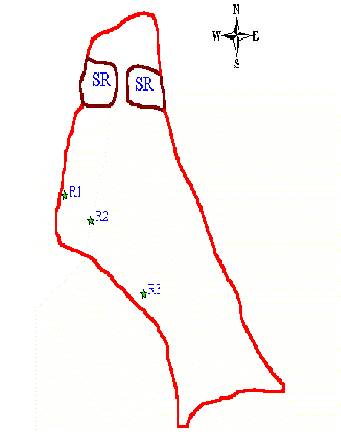
Figure 7: Location of sampling points in Rachenahalli lake.
Scale 1: 50,000.
SR Submerged rocks.
R1 Sampling point 1 (N 13 0 03' 53.4'' E 77 0 36' 50.9'').
R2 Sampling point 2 (N 13 0 03' 50.7'' E 77 0 36' 48.1'').
R3 Sampling point 3 (N 13 0 03' 45.1'' E 77 0 36' 40.1'').
ULSOOR LAKEUlsoor lake situated in the eastern part of the city is spread over an area of about 50 hectares. It has three islands and receives direct industrial and domestic wastewaters from the surrounding area of Tannery road, Ulsoor. The wastewater is aerated and then let into the lake. It has a park in its vicinity, a corporation swimming pool adjacent to the lake. Madras engineering group (MEG) uses this lake for boat training. Fish death was reported in this lake in leading newspapers on January 26 th , 2005. Figure 8 shows the boundary, islands and sampling points in the lake.
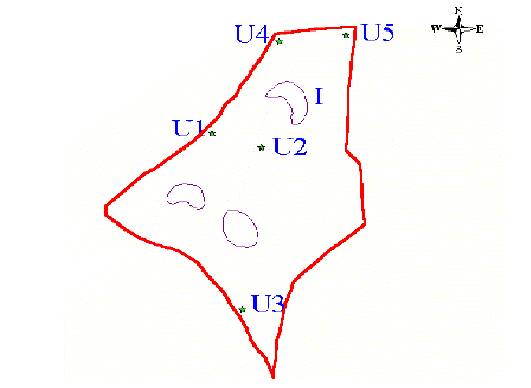
Figure 8: Location of sampling points in Ulsoor lake.
Scale 1:50,000.
I Islands.
U1 Sampling point 1 (N 12 0 58' 57.9'' E 77 0 37' 20.4'' - Madras engineering group).
U2 Sampling point 2 (N 12 0 58' 56.5'' E 77 0 37' 10.4'' - Center of the lake).
U3 Sampling point 3 (N 12 0 58' 40.2'' E 77 0 37' 11.6'' - Outlet).
U4 Sampling point 4 (N 12 0 59' 10.9'' E 77 0 37' 10.9'' - Near inlet).
U5 Sampling point 5 (N 12 0 58' 07.2'' E 77 0 37' 19.5'' - Near fish sales unit).
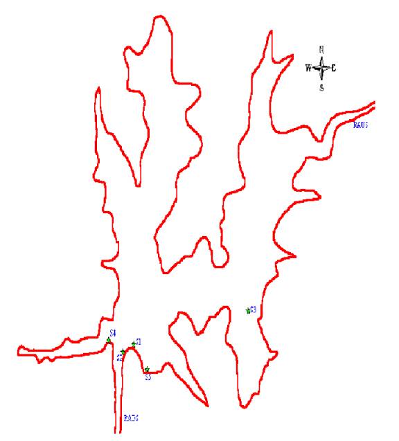
Tippagondanahalli lake is a large lake, which quests the drinking water needs of Bangalore since many decades. The Tippagondanahalli lake is located on the boundaries of three taluks namely Bangalore South, Nelamangala and Magadi of Bangalore rural district. The Nandi hills and Devarayadurga form the catchment area for the lake. The area of the lake is 3.5 sq.miles at maximum capacity of 74 feet. However, the lake has not received adequate rain in the catchment and hence it is drying due to less inflow of water. The inlet to the lake is River Arkavathi, which takes its origin at Nandi hills. The lake supplies 40 million liters of drinking water per day to a part of Bangalore city as opposed to the maximum capacity of 120 million liters per day due to water shortage. Figure 9 gives the sampling points and boundary of the lake.
Figure 9: Location of sampling points in Tippagondanahalli lake.
Scale 1: 50,000
RAUS River Arkavathi upstream.
RADS River Arkavathi downstream.
S1 Sampling point 1 (N 77 0 20' 31.2'' E 12 0 58' 9.6'').
S2 Sampling point 2 (N 77 0 20' 16.7'' E 12 0 57' 49.3'' - Near spill over point).
S3 Sampling point 3 (N 77 0 21' 3.2'' E 12 0 58' 15.9'' - Near inlet).
S4 Sampling point 4 (N 77 0 20' 5.3'' E 12 0 58' 15.9'').
S5 Sampling point 5 (N 77 0 20' 47.9'' E 12 0 57' 10.3'' - Near dam - Inlet to filtration unit).