1. Urban sprawl
Urban sprawl is the outgrowth along the periphery of cities and along highways. Although an accurate definition of urban sprawl may be debated, a consensus is that urban sprawl is characterized by an unplanned and uneven pattern of growth, driven by multitude of processes and leading to inefficient resource utilization. Urbanisation in India has never been as rapid as it is in recent times. As one of the fastest growing economies in the world, India faces stiff challenges in managing the urban sprawl, while ensuring effective delivery of basic services in urban areas. The urban areas contribute significantly to the national economy (more than 50 per cent of GDP), while facing critical challenges in accessing basic services and necessary infrastructure, both social and economic. The overall rise in the population of the urban poor or the increase in travel times due to congestion along road networks are indicators of the effectiveness of planning and governance in assessing and catering for this demand. Agencies of governance at all levels: local bodies, state government and federal government, are facing the brunt of this rapid urban growth. It is imperative for planning and governance to facilitate, augment and service the requisite infrastructure over time systematically. Provision of infrastructure and assurance of the delivery of basic services cannot happen overnight and hence planning has to facilitate forecasting and service provision with appropriate financial mechanisms.
This chapter addresses the issue of urban sprawl in the Indian context with a focus on Bangalore and analyses the status of planning practice in India with a note on utility of spatial planning tools. As a synthesis of the prevailing situation, the ensuing section outlines the critical challenges for addressing sprawl. The subsequent section highlights the need for an integrated spatial planning support system (SPSS), illustrating the evolution of a framework for SPSS, its development and evaluation. The later section presents the policy analysis carried out using the SPSS, which offers insights into areas of concern. The chapter concludes by noting the drawbacks and challenges for future research for managing urban sprawl.
Earlier studies characterise urban sprawl (Barnes et al., 2001; Hurd et al., 2001; Epstein et al., 2002; Sudhira et al., 2004) using spatial metrics while highlighting the implications of sprawl on natural resources and how inefficient unplanned growth could be. Among the undesirable effects of sprawl are unplanned outgrowths which are neither aesthetic nor hygienic. Thus, there have been varied connotations to ascribe what constitutes sprawl. Galster et al. (2001) have addressed this issue as ‘lost in semantic wilderness’, by describing sprawl under six broad categories: by example that embodies characteristics of sprawl, such as Los Angeles; aesthetic judgement and general development pattern; cause of an externality; consequence or effect of independent variables; pattern of development; and process of development.
Extending the notion of urban sprawl articulated by Torrens and Alberti (2000), Galster et al. (2001) define it as a pattern of land-use in an urban agglomeration that exhibits low levels of some combination of eight distinct dimensions: density, continuity, concentration, clustering, centrality, nuclearity, mixed uses and proximity. Ascribing sprawl as a pattern of land-use alone does not throw light on the underlying processes, causes and hence consequences. In a developing country like India, where population density is high with significant urbanization rates, urban sprawl obviously cannot be characterised by pattern alone but processes, causes and their consequences. Hence, we suggest a modification to the definition of urban sprawl as the pattern of outgrowth emergent during the process of urban spatial expansion over time caused by certain externalities and a consequence of inadequate regional planning and governance. The pattern of urban sprawl is characterised by using spatial metrics on the extent of paved surface or built-up areas. The process of urban sprawl can be characterized by changes in the pattern over time, like the proportional increase in the built-up area leading to rapid urban spatial expansion. Analyzing the causes of urban spatial expansion, the externalities can be modelled as agents in a geospatial environment like the location of jobs, housing, access to services and the level of economic activity. The interaction of agents can suggest the consequences on land-use changes. The sequence of patterns, processes, causes and consequences sets the research agenda.
2. Critical challenges for spatial PSS
The management of urban sprawl entails quantifying the pattern of sprawl and capturing the processes that involves analysis of causal driving factors. This requires understanding and visualising the consequences of policies applied by local planning and administrations to sprawl, like the lack of an effective public transport system with varying work-home distances, giving rise to independent motor vehicles and the resultant congestion and spatial expansion. Testing the effects of policy interventions on urban spatial expansion and mobility are some important questions into which a PSS could offer insights. Operational urban planning seeks answers for many such interventions. This necessitates integrated spatial PSS for managing sprawl. The framework of such PSS is discussed in the Section 4.
Noting the various studies and prevailing urban fabric conditions in India, it is found that lack of effective governance with operational systems and processes in local bodies of governance have resulted in unplanned and uncoordinated urban outgrowths. Urban governance requires an information system for keeping track of various services and functions of the urban local body. In the absence of any such systems, at the basic level, there is a strong and pressing need for an information system to cater for all these. In the next level, it becomes essential to build models based on the information systems involving simulation and analysis for specific urban contexts. Thereafter, there is a subsequent level involving the formulation of different strategy and policy options using the models and information systems. Thus, at the outset, there are three levels to address the problem of sprawl and to strengthen planning and decision making – information systems, models and policies. Emphasizing this need, Sudhira et al. (2007) have discussed in detail the planning and management practices in India. With the interaction of key bureaucrats and concerned officials in Bangalore City Corporation, it is found that, on one hand, the prevailing policy and practices concerning planning and governance are in line with the State Government’s aspirations, while on the other hand, there does not exist any other mechanisms or modes through which the Government could make this effective and plausible by being citizen centric. The key challenge for research is to encapsulate the spatial information coupled with models to facilitate policy analysis, evaluation and visualisation of these consequences into a spatial PSS.
3. Planning in t digital age: GIS/spatial analysis and planning toolshe
Spatial tools, notably geographic information systems (GIS) for mapping and monitoring urban areas, have become extremely popular. Monitoring the spatial patterns of urban sprawl on a temporal scale can be undertaken using temporal remote sensing data acquired from space borne sensors. These help in inventorying, mapping and monitoring linear and radial growth patterns. In the recent past, the geospatial domain has seen significant developments in modelling urban systems using approaches ranging from operations research to system dynamics and agent-based models. Models of urban systems are essentially built to aid in planning for understanding, evaluating, visualising and deciding various interventions. Thus geospatial models have become an inseparable aspect of a PSS. In India, there are some attempts to address urban sprawl using geospatial tools (Jothimani, 1997; Lata et al., 2001; Subudhi and Maithani, 2001; Sudhira et al., 2004) and modelling (Subudhi and Maithani, 2001).
Simulation tools based on the concepts of discrete-event system simulation approaches are being used extensively in recent times to capture and emulate urban systems and their dynamics. With the emergence of multi-agent systems from the domain of artificial intelligence, these are now being used to aid in simulation of urban systems. Another approach to model the urban dynamics is the system dynamics (SD) framework, which captures the system based on complexity involving dynamic relations represented by stocks and flows determined by various activity volumes in the city, which are synthesised from knowledge and observation. Operations research approaches and the SD framework have been applied quite rigorously in urban systems, and in the recent times, geospatial modelling aided by visualisation has been very effective.
Globally, modelling urban sprawl dynamics has closely followed traditional urban growth modelling approaches. Subsequently, with the need to manage urban sprawl, modelling urban sprawl by understanding the nature of growth and its implications has been undertaken since 1960s. The key initial studies in developed countries based on traditional approaches of urban model building include Lowry (1967 in Batty and Torrens, 2001), Walter (1975), Allen and Sanglier (1979), and Pumain et al. (1986). The traditional model building approach involved linking independent to statistically significant dependent variables in a linear or non-linear model. These models although used mostly for policy purposes, could not be used when the processes involved rule-based systems (Batty and Torrens, 2001). Whilst urban development models were developed much earlier, modelling the dynamics of urban sprawl has been undertaken only recently (Batty et al., 1999; Torrens and Alberti, 2000). Models developed using cellular automata (CA) and agent-based models would prove beneficial to pinpoint where sprawl takes place (including causal factors), which would help in effective visualisation and understanding of the impacts of urban sprawl. Furthermore, to achieve an efficient simulation of urban sprawl, modelling has to be attempted in both spatial and non-spatial domains. Modelling urban sprawl in non-spatial domain is mainly by the application of statistical techniques while CA models and agent-based modelling are known to complement modelling in the spatial domain. The fusion of geospatial and agent-based models has been formalised as geographic automata systems (GAS) by Benenson and Torrens (2004). These approaches and research in geospatial modelling towards a simulation framework can effectively complement a spatial PSS.
4. Integrated spatial planning support systems
For effectively managing the problem of urban sprawl; testing, building and visualising different scenarios, it is imperative to have a robust spatial PSS which would not only aid in managing but also in planning, organising, coordinating, monitoring and evaluating the system in question. Spatial PSS include instruments relating to geo-information technology that have been primarily developed to support different aspects of the planning process, including problem diagnosis, data collection, mining and extraction, spatial and temporal analysis, data modelling, visualisation and display, scenario-building and projection, plan formulation and evaluation, report preparation, enhanced participation and collaborative decision making (Geertman and Stillwell, 2004). Integration of different processes associated with the dynamics of sprawl phenomenon is required for addressing the problem of urban sprawl.
Currently there are few popular systems that try to emulate spatial PSS with an objective to make planning interactive and participatory. Among such existing PSS are What-If? (Klosterman, 1999) and RAMCO (Uljee et al., 1999). Klosterman’s What-If? system is an interactive GIS-based PSS that responds directly to both achieving the ideals of communicative rationality and traditional comprehensive land-use plans. It uses geographic data sets to support community-based efforts to evaluate the likely implications of alternative public policy choices. The package can be customised to a community’s existing geographic data, concerns and desires, providing outputs in easy to understand maps and reports which can be used to support community-based collaborative planning efforts. Given a set of factors and factor weights for determining land suitability, the What-if ? PSS generates projections for future land-use and subsequent land allocation can be based on user requirements. Although this system is claimed to be interactive, the dynamics of the factors and hence their interactions are less transparent, with only the results of a final land-use scenario obtained as output.
RAMCO (Rapid Assessment for Management of COastal zones) is a prototype information system for regional planning in a generic decision support environment for the management of coastal zones through the rapid assessment of problems (Uljee et al., 1999). The system was developed by integrating GIS, CA and SD. Subsequently, White and Engelen (2000), the developers of RAMCO, also support the integration of GIS, CA and SD with the usage of multi-agent systems for a high-resolution integrated modelling of spatial dynamics of urban and regional systems. This has currently set the standard of technology that can be used for achieving an integrated PSS.
UrbanSim and OBEUS are two other established frameworks with supporting packages for integrated modelling of urban systems. UrbanSim is implemented as a set of packages under Open Platform for Urban Simulation (OPUS) (Waddell et al., 2005). This is fairly comprehensive in the sense that the framework integrates land-use, transportation, economic, demographic and environment variables. However, this framework does not support participatory simulations. The OBEUS (Object-Based Environment for Urban Systems) is more robust and represents an emerging trend to integrate various processes as agent-based models and to simulate them spatially, hence the term ‘geosimulation’ (Benenson and Torrens, 2004).
4.1 Framework for spatial PSS
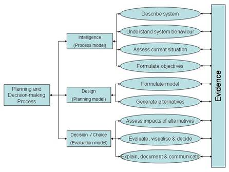
The framework for a planning and decision making process involving different phases of intelligence, design and decision/choice (Sharifi, 2003) is depicted in Figure 1. The intelligence phase is confined to defining, understanding and assessing the existing situation along with evolving appropriate metrics for quantifying urban sprawl. In the design phase, the dynamics of urban sprawl are captured and subsequently modelled. The design phase concludes with the generation of alternatives. In the decision/choice phase, the review and evaluation of the different policy options are undertaken to arrive at policy recommendations for managing and mitigating the urban sprawl.
Figure 1 : The planning and decision-making process (Sharifi, 2003)
4.2 Evolution of SPSS through integrated SD and agent-based land-use models
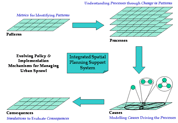
Keeping in line with the framework for planning and decision-making suggested by Sharifi (2003), a prototype of the SPSS was developed with the following four components: patterns, processes, causes and consequences. Accordingly, the evolution of the PSS is depicted in Figure 2.
Figure 2 : Evolution of the PSS
Modelling the dynamics of urban sprawl is attempted by a combination of system dynamics and agent-based models over a geospatial domain (Sudhira and Ramachandra, 2007). Initially, the land-use of the region, Bangalore, was characterised using the satellite remote sensing data and the metrics for depicting the patterns were computed accordingly. A multi-stage classification process was employed resulting in classification of the entire landscape into four broad land-use categories. In order to characterise sprawl, some of the metrics computed are: built-up area, built-up density, patchiness (all spatial metrics), population and their densities. Apart from these metrics the percentage of different land-uses were also monitored. Further, to attempt modelling the processes and causes using system dynamics, variables were identified and depicted in a causal loop diagram.
The process of modelling in system dynamics begins with a clear statement of the problem, followed by gathering necessary data and identifying the key variables contributing to the problem. The variables are mapped on to what is referred to as causal loop diagrams (CLDs). With the gathered data and establishing relations with the variables amongst the variables are the stock flow diagrams created. It is possible to simulate the behaviour of the system through a stock flow diagram and plot the behaviour of key variables, test for different hypothesis and study the implications of specific interventions. The problem in question here is the pressure on land due to the extent of city outgrowth or the sprawl. The consequences of the interventions that can be attempted towards addressing this are analysed through this analysis.
In Bangalore, one of the prominent measures to limit growth is by way of enforcing building height restrictions formalised through the floor area ratio (FAR). These restrictions are one of the popular measures of controlling the zoning of central and several parts of the city. Though the planners in Bangalore have already enforced such restrictions, this in turn has also resulted in increasing the extent of the city outgrowth. SPSS intends to explore the options of relaxations with the FAR to visualize the probable land-use patterns, which would be of interest for planners.
Accordingly, based on the analysis, the key variables identified were: population growth, economic activity, pressure for new housing and industrial areas, land-use zoning, available land, built-up area, level of services and building height restrictions. The typical approach to cause-effect modelling, the ‘disjointed viewpoint’ and ‘linear, control viewpoint’ of one cause leading to one effect, is replaced by a ‘causal-loop, nonlinear feedback viewpoint’ where multiple effects are the result of multiple factors (Sterman, 2004), as also depicted in Figure 3.
Figure 3 : Causal loop diagram for urban sprawl
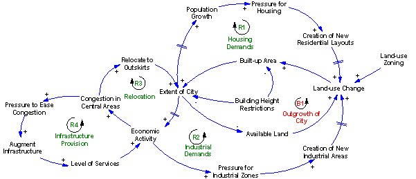
Analysing the feedbacks generated – reinforcing and balancing, the resultant dynamics reveal that certain practices are actually proving counter-productive. The five feedbacks generated in this system are: (i) reinforcing feedbacks: housing demands (R1); industrial demands (R2); relocation (R3) and infrastructure provision (R4); and (ii) balancing feedback: outgrowth of the city (B1). The reinforcing feedbacks, R1 and R2, quite natural for most cities, set the demand for development of land into residential layouts/apartments or industrial estates, respectively. As the city grows, there is congestion in central areas forcing residents to relocate in the outskirts. This is captured by the reinforcing feedback, R3. The other reinforcing feedback, R4, for infrastructure provision suggests that augmenting infrastructure in a congested area can be counter-productive. Indeed this insight is well established by the classic Braess paradox (Braess, 1968). This was demonstrated by adding a link within the network to ease congestion would be counter-intuitive in a congested road network. Reinforcing feedbacks often generate exponential growth and then collapse. Systems that are self-regulating or self-correcting are comprised of balancing loops. The only balancing feedback, B1, results in the outgrowth of the city through the process of land-use change limited by the availability of land for development. The other control variable, building height restrictions, suggests that it influences the extent of outgrowth and built-up areas negatively. Bertaud and Brueckner (2004) have shown that in an unrestrictive building height conditions the extent of the city spread is contained with higher densities in central areas.
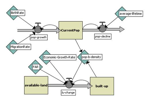
Further, the causal loop diagram is translated into a stock-and-flow diagram with appropriate numbers for the variables and assumptions. An important assumption relating to the process of land-use change was that economic activity combined with an increase in the workforce (through migration) would lead to higher demand for land for development and hence drive the land-use change. It is observed that it is the market forces operating in the context of a market economy, which are influencing the process of land-use change. Thus the analysis of land-use change has to acknowledge the implications of prevailing market conditions and the supply and demand aspects of land. The stock-and-flow diagram capturing the dynamics of population growth and land-use change is depicted in Figure 4. Essentially the stock-and-flow diagram sets the demand for new built-up areas.
Figure 4 : Stock and flow diagram capturing population growth and land-use change
4.3 Prototype design and implementation
4.3.1 Visualisation environment, design and implementation
The prototype of the spatial PSS has been developed as the BangaloreSim model, implemented using NetLogo (Wilensky, 1999), an agent-based modelling environment developed by the Centre for Connected Learning and Computer Based Modelling, Northwestern University, USA which facilitates encapsulation of processes through rule-based procedures and offers adequate monitors and plots to visualize pattern, model the causes and evaluate the consequences through simulation. The pseudo code of the BangaloreSim model is presented in Figure 5, which outlines the sequence of processes involved in the simulation.
| Figure 5 : BangaloreSim model pseudo code |
INITIALIZATION
Set Parameters -> User Defined or Set from earlier start-up
Import land-use data, elevation, transportation networks and CDP (Land-use Policy)
Initialise System Dynamics setup
- Initialise for Population, Economic Growth Rate (City Development Product), Available Land
EACH TIME STEP
Check for Simulation End Time and Available Land [Stop run if exceeds either of them]
Compute Demand for Land (Inputs from System Dynamics Model – Stock & Flow Diagram)
- Population Growth Model Runs -> Current Population
- Current Population -> Population Density -> Land-use Change
- Land-use Change ~ Population Density, Available Land, Economic Growth Rate
- Land-use Change ~ Requirement for New Built-up
Change Land-use
- Obtains Built-up Demand from Land-use Change
- Site-Suitability
- Suitability for patches based on Distance from City Centre, Transportation Networks, Weightages for Certain Land-use based & LU Policy, and Proximity to Growth Pole
- Allocate Land
- Check for Built-up Demand [Stop run if exceeds current built-up or No Available Land]
- Check for Maximum Site Suitability in the Neighbourhood (3x3) and allocate Land-use to Built-up
Compute Metrics ~ Check for Impacts on Resources and Access to Services
Update Views and Draw Plots
END
Agents are Growth Pole centres influencing land-use in their neighbourhood |
4.3.2 Development of Prototype and Evaluation
Among the key criteria considered during the prototype development was enabling the user-interface for visualisation of land-use along with the other requisite metrics in the common interface. Thus, the entire parameters are presented in a single interface with provisions to change views for different land-uses, sprawl metrics, transportation networks,
land-use policy (the comprehensive development plan) and suitability. Subsequently, for a spatial PSS to be effective, it would require the modeller/expert to control relevant parameters for generating scenarios simultaneously enabling dynamic interaction. Considering these key criteria, the prototype developed is depicted in Figure 6. The base year for the model was considered as 2000 with the classified land-use map for the same year serving as the input.
Figure 6 : Prototype of the SPSS
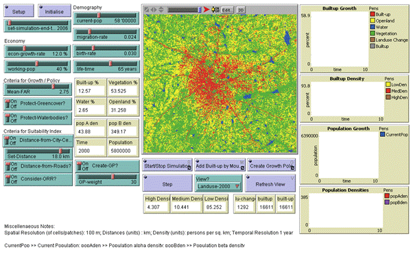
The evaluation of the spatial PSS involved calibration of the suitability weights with mean floor area ratio and location of industrial estates as growth-poles. The FAR was set to 2.75 based on the average permissible ratio of the land-use zoning policy. Considering these model set-up parameters, the suitability weights for different factors like land-uses, distance from city centre and distance from transportation network were calibrated. The calibration for the weights was performed comparing the classified land-use and the simulated land-use for 2006.
In the earlier test simulations (before acknowledging growth poles) the land-use changes could not forecast the land-use for 2006 appropriately. There were other initiatives by the State Government like the creation of an outer ring road, which were captured in the system. The industrial estates were ascribed as a growth pole (GP) agent to capture these changes. The GP agent essentially boosts suitability of any particular land-use in the neighbourhood with the greater probability to change into built-up (see underlined procedure in the pseudo code in Figure 5).
The simulation for year 2006 considering the influence of growth-pole agents and the mean FAR with the calibrated weights for suitability is presented in Figure 7. The comparison of these outputs were also analysed using the Map Comparison Kit 3 (Hagen-Zaker et al. 2006). The simulated land-use (Figure 7(a)) was compared with the classified land-use of 2006 (Figure 7(b)). The Kappa statistic of built-up areas was 0.413 and Kloc was 0.427 with Moran’s I for the simulated and classified image being 0.643. The calibrated model was then used to perform policy analysis.
| Figure 7 : Classified and simulated land-use of Bangalore for 2006
|
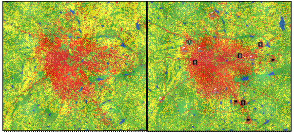 (a) Classified land-use (2006) (b) Simulated land-use (2006) (a) Classified land-use (2006) (b) Simulated land-use (2006) |
4.4 Policy analysis
The scope of policy analysis is restricted for evaluating the impact of increasing floor area ratio on extent of sprawl up to year 2015. The effect on sprawl was analysed based on the percentage built-up areas and built-up densities. The simulations revealed that higher FAR resulted in increase of built-up areas (386.6 sq. km, 93.2 per cent) with high densities and the rate of built-up growth declining. However, during the duration of increase in density of built-up areas, the population ‘b-density’ (population over built-up area) depicted ‘U’ type behaviour. Accordingly, the population b-density decreased initially and increased after certain duration of time. This suggests that initially the expansion of the built-up area in spite of FAR continued and only after a threshold, the population chose to locate within the city’s extent over locating in the outskirts. The increase in built-up areas with high densities suggests more congestion in certain parts of city. It is in these parts wherein infrastructure and services needs to be augmented to accommodate the forecasted population b-densities. The policy analysis revealed the probable effects of change in FAR on extent of built-up areas and their densities. The spatial PSS was effective in locating areas with higher densities of built-up area and requiring augmentation of infrastructure and services to relieve of impending congestion in these localities. While this exercise was useful in generating a scenario of urban land-use, there can be many more scenarios generated by undertaking the simulations for different policy settings to understand their respective consequences.
4.5 Drawbacks and recommendations
An important distinction in the spatial PSS was the ability to incorporate the process that lead to land-use changes like creation of growth poles and studying the effect of outgrowth through the FAR. A spatial PSS thus facilitates the analysis of choices, visualisation of such decisions and evaluation of certain policy decisions. However, the success of these will rest on the modellers and planners who can identify and capture these processes to realise the best possibilities from a PSS.
The scale of analysis affects the computational complexity of the system. Higher spatial scales increase the computational resources required to perform the simulations optimally and vice versa. In the current model, the spatial scale is set for 100 metres x 100 metres grid, with yearly time scales. Caution should also be exercised on the choice of scale based on the problem and processes that are modelled.
The research here is yet to validate the spatial PSS with the government functionaries. Validation of agent-based land-use models has been a contentious issue in recent times. However, recent work by Brown et al. (2005) has attempted to clarify this debate by acknowledging path dependence and bringing out the distinction of achieving predictive accuracy and process accuracy. Consequently, it is important that any spatial PSS should have greater process accuracy and be able to generate patterns resulting out of numerous processes. But planners and decision makers would always want some amount of predictive accuracy informing them what type/pattern of growth will emerge at which locations. Thus spatial PSS should be ideally achieving reasonable predictive and process accuracies. The process accuracy and predictive accuracy of this model is yet to be ascertained. However, the spatial PSS in its current state allows the modeller or experimenter to test for various options and evaluate the consequences.
The contention of the process accuracy can be either addressed by following a similar approach of Brown et al. (2005) or engaging in a focus group evaluation involving key bureaucrats, planners, policy makers and experts who would verify the processes captured in the SPSS and outcomes of the simulation in the SPSS. With such a focus group evaluation, it will also make it beneficial for SPSS to be adopted in their current planning practices.
5. Conclusions and future directions
Proper implementation of master/development plans is a critical aspect in regulating the development of urban areas. Although 1,200 master/development plans for important towns and cities have been prepared in India, their implementation so far has not been satisfactory due to a variety of reasons. City planning mainly addresses the preparation of land-use plans through zoning to cater for projected populations. However, civic authorities also need to plan for meeting the demand for infrastructure facilities and ensuring delivery of basic services. This is dismal in current planning practice since these are normally static master plans or development plans mostly addressing land-use issues. These plans are also less equipped to review and evaluate any policy decisions dynamically by visualising the potential implications of a policy directive and the regions of potential sprawl. It is therefore necessary to support administrators and planners by providing them with better understanding, methods and tools to tackle the problem of urban sprawl. Further, administrators and planners need to be informed of possible areas of sprawl to take corrective actions to mitigate the implications. The problem of urban sprawl is observed to be an outcome of improper planning, inadequate policies and lack of effective governance due to various reasons. The inability of the administration and planning machinery to visualise probable areas of sprawl and its growth is persistent with the lack of appropriate spatial information and indicators.
Thus, in the present context, with the escalating problem of urban sprawl, the evolution of a PSS in the form of the BangaloreSim model is the first step in this direction. The PSS aids in undertaking policy analysis for certain policy measures and its impact on urban land-use. The PSS was also effective in evaluating the influence of FAR on controlling urban sprawl. However, there are numerous challenges for incorporating the complex urban system in a dynamic modelling framework with which to support participatory decision making. The PSS can be used to regularly monitor and check the nature of sprawl for compliance with policy recommendations over time.
Most PSS allow analysis, evaluation and visualisation only on standalone systems, wherein each stakeholder has to choose/decide the options on same system/platform. This would suggest that all stakeholders have to meet physically to evaluate and decide. Moreover, such initiatives are not normal and very difficult to moderate. In this context, it becomes necessary for a parallel and distributed simulation framework to support PSS, so that all stakeholders and managers/administrators are able to interact, organise, plan, evaluate and decide through a network. Then the challenges are two fold: initially to integrate different models that are required to carry out the simulations, and then to synchronise the model inputs, feedbacks and outputs over space and time. Design of PSS with participatory simulation framework will largely contribute to its ready usage in urban planning and decision-making process.
The PSS is developed on an agent-based modelling environment as a process-based land-use model. The developments in PSS can significantly complement research in temporal geographic information science transforming the temporally static GIS to temporally dynamic systems. The exchange of geospatial data (import and export functions) is now possible for ASCII grid formats. In future, it is imperative that these systems are interoperable and support most of the standard geospatial formats. Provision of PSS over the internet can also imply that they may be accessible to everyone and can become pervasive. Such a web-based PSS can be a very effective tool for monitoring, planning and decision-making encouraging community participation. At the outset, the future development of the PSS can facilitate exchange of standard geospatial data formats and evolve as a web-based system.
Acknowledgements
We thank Indian Institute of Science for financial and infrastructure support. The Global Land Cover Facility (GLCF), Institute for Advanced Computer Studies, University of Maryland, USA and the National Remote Sensing Agency (NRSA), Department of Space, Government of India is duly acknowledged for making available the remote sensing satellite data for the study.
References
Allen, P.M. and Sanglier, M. (1979) A dynamic model of urban growth: II, Journal of Social and Biological Systems, 2(4): 269-278.
Batty M., Xie Y., and Sun Z. (1999) The dynamics of urban sprawl, Working Paper Series, Paper 15, Centre for Advanced Spatial Analysis, University College London, England.
Batty, M. and Torrens, P. (2001) Modelling complexity: the limits to prediction, Working Paper Series, Paper 36, Centre for Advanced Spatial Analysis, University College London, England.
Benenson I. and Torrens P.M. (2004) Geosimulation: Automata-based Modeling of Urban Phenomena, John Wiley and Sons, Chichester.
Braess D. (1968) Ãoeber ein paradoxon aus der verkehrsplanung, Mathematical Methods of Operations Research, 12(1): 258-268.
Brown, G. D., Page, S., Riolo, R., Zellner, M. and Rand, W. (2005) Path dependence and the validation of agent-based spatial models of land-use, International Journal of Geographic Information Science, 19(2): 153-174.
Galster, G., Hanson, R., Ratcliffe, M.R., Wolman, H., Coleman, S. and Freihage, J. (2001) Wrestling sprawl to the ground: defining and measuring an elusive concept, Housing Policy Debate, 12(4): 681-717.
Geertman, S. and Stillwell, J. (2004) Planning support systems: an inventory of current practice, Computers, Environment and Urban Systems, 28(4): 291-310.
Hagen-Zanker, A., Engelen, G., Hurkens, J., Vanhout, R. and Uljee, I. (2006). Map Comparison Kit 3, Research Institute of Knowledge Systems (RIKS bv), Maastricht, The Netherlands, from http://www.riks.nl/mck
Jothimani, P. (1997) Operational urban sprawl monitoring using satellite remote sensing: excerpts from the studies of Ahmedabad, Vadodara and Surat, India, 18th Asian Conference on Remote Sensing, Malaysia 20-24, October, 1997.
Klosterman, R. E. (1999) The What If? collaborative support system, Environment and Planning B, 26: 393-408.
Lata, K. M., Sankar Rao, C. H., Krishna Prasad, V., Badrinath, K. V. S. and Raghavaswamy (2001) Measuring urban sprawl: a case study of Hyderabad, GIS Development, 5(12): 22-25.
Lowry, I.S. (1967) Seven models of urban development: a structural comparison, In Hemmens, G.C. (ed.) Urban Development Models, Special Report 97, Highway Research Board, Washington DC, 121-163.
Pumain, D., Saint-Julien, T. and Sanders, L. (1986) Urban dynamics of some French cities, European Journal of Operational Research, 25(1): 3-10.
Sharifi M. A. (2003) Integrated Planning and Decision Support Systems for Sustainable Water Resources Management: Concepts, Potentials and Limitations, Seminar on Water Resources Management for Sustainable Agricultural Productivity, organized by Asian Productivity Organization, Lahore, Pakistan.
Sterman, J. D. (2000) Business Dynamics: Systems Thinking and Modeling for a Complex World, Irwin McGraw-Hill, Boston.
Subudhi, A. P. and Maithani S. (2001) Modeling urban sprawl and future population prediction using remote sensing and geographical information system techniques. In: Subudhi, A.P., Sokhi, B.S. and Roy, P.S. (eds.) Remote Sensing and GIS Application in Urban and Regional Studies, Human Settlement and Analysis Group, Indian Institute of Remote Sensing, Dehradun, India.
Sudhira, H. S. and Ramachandra T.V. (2007) Modelling the dynamics of urban sprawl using system dynamics and agent-based models, International Conference on Framing Land Use Dynamics II, University of Utrecht, The Netherlands, 18-20, April 2007.
Sudhira, H. S., Ramachandra, T. V. and Bala Subrahmanya M. H. (2007) Integrated Spatial Planning Support Systems for Managing Urban Sprawl, 10th International Conference on Computers in Urban Planning and Urban Management (CUPUM), Iguassu Falls, Brazil, 11-13, July 2007.
Sudhira, H. S., Ramachandra, T.V. and Jagadish, K.S. (2004) Urban sprawl: metrics, dynamics and modelling using GIS, International Journal of Applied Earth Observation and Geoinformation, 5(1):29-39.
Sudhira, H.S., Ramachandra, T.V., Raj, K.S. and Jagadish, K.S. (2003) Urban growth analysis using spatial and temporal data, Photonirvachak, Journal of Indian Society of Remote Sensing, 31(4): 299-311.
Torrens, P.M. and Alberti, M. (2000) Measuring sprawl, Working Paper Series, Paper 27, Centre for Advanced Spatial Analysis, University College, London.
Uljee, I., Engelen, G. and White, R. (1999) Integral Assessment Module for Coastal Zone Management, RAMCO 2.0 User Guide, Research Institute of Knowledge Systems BV, Maastricht, The Netherlands.
United Nations (2004) Executive Summary, World Urbanisation Prospects: The 2003 Revision, Population Division, Department of Economic and Social Affairs, United Nations, New York, USA.
Waddell, P. (2002) UrbanSim: Modeling urban development for land-use, transportation and environmental planning, Journal of the American Planning Association, 68(3): 297-314.
Walter, H. (1975) Urban Systems Models, Academic Press, USA.
White, R. and Engelen, G. (2000) High-resolution integrated modelling of the spatial dynamics of urban and regional system, Computers, Environment and Urban Systems, 24: 383-400.
Wilensky, U. (1999) NetLogo, Center for Connected Learning and Computer-Based Modeling, Northwestern University, Evanston, IL, USA. from http://ccl.northwestern.edu/netlogo
Additional Reading
Batty, M. (2001) Models in planning: technological imperatives and changing roles, International Journal of Applied Earth Observation and Geoinformation, 3(3): 252-266.
Batty, M. and Torrens, P.M. (2005) Modelling and prediction in a complex world, Futures, 37: 745-766.
Couclelis, H. (2004) The construction of digital city, Environmental and Planning B, 31: 5-19.
Forrester, J.W. (1969) Urban Dynamics, Wright Allen Press, Cambridge, Massachusetts.
Gakenheimer, R. (2002) Planning, transportation and land use for cities in India, Workshop on Integrated Planning for Transportation, Land Use and the Environment in Indian Cities, Harvard University Centre for Environment and Administrative Staff College of India, Hyderabad.
Wegener, M. (1994) Operational urban models: state of the art, Journal of the American Planning Association, 60: 17-29.