INTRODUCTION |
Fisheries play an important role in augmenting food supply and raising nutritional levels, generating employment and foreign exchange. Water bodies with fish communities relatively unaffected by man have tremendous genetic significance. Fishes have a key role in monitoring water quality. All too often, the first sign of pollution is dead fish. Fish species composition of any lake is related to the water quality, chemistry and morphology of the lake as well as the characteristics and productivity of the watershed.
Fishes by far play the most important role in aquatic ecosystems. They occupy a high position in the trophic level of aquatic organisms, depend much on the quality of primary producers, consumers of lower order and the water quality. They are quite susceptible to sudden or drastic changes in the physico-chemical properties of water, which occur due to natural or anthropogenic activities. Natural events include the seasonal variations but in most cases of fish mortality reported so far, the main agents are sewage, industrial effluents, spraying of various biocides etc. Fish kills are classified into minor, moderate and major types and it was noticed that a significant correlation exists between the extent of fish kill and the status / quality of water.
Previous investigations report that low dissolved oxygen levels are mainly responsible for fish kill. Benjamin et.al, (1995) carried out an intensive study of the water, soil and fish samples after a large-scale fish mortality in Sankey tank, Bangalore during June-July 1995. Investigations revealed that the sewage let into the tank caused a drastic decrease in the dissolved oxygen levels (avg. 3.026 mg/l).
Surveys on the impact and evaluation of water pollution on the reservoir fisheries with special reference to microorganisms were conducted in Kumaun (Himalayas, India) by several investigators (Jhigran, 1990; Wilson J.G 1976; Pant et. al, 1985; Pathak, J. K. and Bhatt, S. D., 1995; Khulbe et.al, 1988). Water quality in this area deteriorated due to the inflow of sewage and industrial effluents and construction activities in the catchment area. The decrease in water quality has incontestably brought a massive increase in fish mortality. Contaminated waters harbour diverse microorganisms, which act as potential pathogens to aquatic organisms, especially fish. Microbiological analysis revealed the presence of coliform due to faecal contamination.
India is endowed with both inland and marine fisheries. This resource potential is estimated at approximately 8.4 million tonnes/annum. In the marine sector, India has a long coastline of 8085 km. The inland fishing sector comprises a water-spread of about 6.87 million hectares (brackish water - 1.4 million hectares, reservoirs - 1.97 million hectares, tanks and ponds - 2.2 million hectares, oxbow lakes and derelict water - 1.3 million hectares) and 0.16 million km of rivers and canals with immense scope and potential for capture and culture fisheries.
The state of Karnataka, India has about 2000 perennial and about 30,000 seasonal tanks with a total water spread area of 3,000,000 hectares. The average annual fish yield from these tanks is estimated to be about 350 kg per hectare per year.
Mysore district is located between latitude 11?45' to 12?40' N and longitude 75?57' to 77?15' E. The district covers an area of about 6940 sq. km. There are about 86 major tanks and 921 minor tanks with a total water spread of 11,230 hectares. The lake water is mainly used for agriculture, fishery and drinking. As the district has no coastline, fishing is confined to inland waters. The district contributes 5,322 metric tonnes of inland fish out of the state total of 40,000 tonnes per year.
The climate of the district is moderate throughout the year, temperature ranging from 16.1? C to 31.1? C during winter (Nov. to Feb.) and 19.7? C to 35.1? C in summer. The rainy season extends from May to October with a maximum annual rainfall of 620880mm.
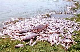
Yennehole or Dadadahalli kere is situated on the Ooty - Mysore main road in Mysore taluk. The lake covers an area of 485.8 hectares with a mean depth of 10m. The water of this lake is mainly used for agriculture and fishery.Figs. 1 to 4 show some features of the lake including the fish mortality