|
Wetlands (and lakes) constitute the most productive ecosystems with a wide array of goods and services. These ecosystems serve as life support systems; serve as habitat for a variety of organisms including migratory birds for food and shelter. They aid in bioremediation and hence aptly known as ‘kidneys of the landscape’.
Water bodies constitute vital components of the regional hydrological cycle. Major services include flood control, wastewater treatment, arresting sediment load, drinking water, protein production, and more importantly recharging of aquifers apart from aiding as sinks and climate stabilisers. The wetlands provide a low cost way to treat the community’s wastewater, while simultaneously functioning as wild fauna sanctuary with public access. These ecosystems are valuable for education and scientific endeavours due to rich biodiversity. They also enhance the aesthetics of the landscape and support many significant recreational, social, and cultural activities, aside from being a part of our cultural heritage.
Today, most urban wetlands are being seriously threatened by conversion to non-wetland purposes, encroachment of drainage through landfilling, pollution (sustained inflow of untreated domestic and industrial effluents, disposal of solid wastes), hydrological alterations (water withdrawal and inflow changes), and overexploitation of their natural resources. This results in loss of biodiversity and disruption in goods and services provided by wetlands. These are highly productive ecosystems, evident from the tangible benefits (fish, fodder, etc.) of Rs10500 per hectare/day at Rachenhalli Lake.
Bengaluru is experiencing unprecedented rapid urbanisation due to concentrated developmental activities with focus on industrialisation for the economic development of the region. This has led to large-scale land cover changes with serious environmental degradation. The process has posed serious challenges such as climate change, enhanced greenhouse gases emissions (Ramachandra et al., 2012; 2015), lack of appropriate infrastructure, traffic congestion, and lack of basic amenities (electricity, water, and sanitation) in many localities, etc. Apart from this, major implications of urbanisation are:
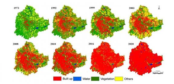
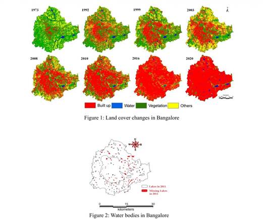
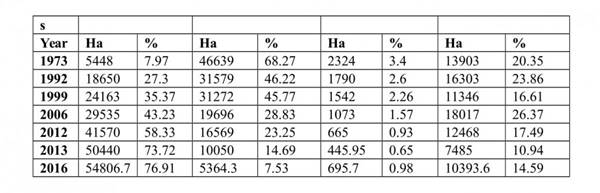
Loss of wetlands and green spaces: Urbanisation (1005% concretisation or paved surface increase) has telling influences on the natural resources such as decline in green spaces (88% decline in vegetation) including wetlands (79% decline) and / or depleting groundwater table. Table 1 and Figure 1 gives an insight to the temporal land cover changes during 1973 to 2013. The built-up area has increased from 7.97% in 1973 to 58.33 % in 2012 (Ramachandra et al, 2012) and 73.72% in 2013 (Table 1). Bengaluru, once branded as the Garden city due to dense vegetation cover, has seen its green cover decline from 68.27% (1973) to less than 15% (2013). Similar to vegetation, Bengaluru was also known as City of Lakes for its numerous lakes (209 lakes). The impact of urbanisation has diminished lake bodies (93 lakes as per 2011) (Figure 2) and also loss of feeder canals (rajakaluve). The water bodies have reduced from 3.4% (1973) to less than 1% (2013). Quantification of number of trees in the region using remote sensing data with field census reveal 1.5 million trees to a human population of 9.5 million, indicating one tree for seven persons in the city. This is insufficient even to sequester respiratory carbon (due to breathing which ranges from 540 -900 g per person per day). Geo-visualisation of likely land uses in 2020 through multi-criteria decision making techniques (Fuzzy-AHP: Analytical Hierarchal Process) reveals calamitous picture of 93% of Bengaluru landscape filled with paved surfaces (urban cover) and drastic reduction in open spaces and green cover. This would make the region GHG rich, water scarce, non-resilient and unlivable, depriving the city dwellers of clean air, water and environment.
Temporal Land use dynamics
Latest field survey of 105 wetlands (Ramachandra et al., 2016) reveals that lakes (98%) have been encroached for illegal buildings (high rise apartments, commercial building, slums, etc.). A field survey of all lakes (in 2014-15) showed that nearly 90% of lakes are sewage fed, 38% surrounded by slums and 82% showed loss of catchment area. Also, lake catchments were used as dumping yards for either municipal solid waste or building debris. The surroundings of these lakes have illegal buildings and most of the time slum dwellers occupy the adjoining areas. At many sites, water is used for washing and household activities and even fishing was observed at one of these sites. Multi-storied buildings have come up on some lake beds that have intervened in the natural catchment flow leading to sharp decline and deteriorating quality of water bodies. Unauthorised construction in valley zones, lakebeds and rajakaluves highlight the apathy of decision makers while revealing weak and corrupt governance. This is correlated with the increase in concrete area (built up area, etc.), affecting severely open spaces and in particular water bodies.
Floods: Conversion of wetlands to residential and commercial layouts has compounded the problem by removing the interconnectivities in an undulating terrain. Encroachment of natural drains, alteration of topography involving the construction of high-rise buildings, removal of vegetative cover, reclamation of wetlands are the prime reasons for frequent flooding even during normal rainfall post 2000.
Decline in groundwater table: Studies reveal the removal of wetlands has led to the decline in water table. Water table has declined to 300 m from 28 m over a period of 20 years after the reclamation of lake with its catchment for commercial activities. In addition, groundwater table in intensely urbanised area such as Whitefield, etc. has now dropped to 400 to 500m.
Heat island: Surface and atmospheric temperatures are increased by anthropogenic heat discharge due to energy consumption, increased land surface coverage by artificial materials having high heat capacities and conductivities, and the associated decreases in vegetation and water pervious surfaces, which reduce surface temperature through evapotranspiration. The study unravels the pattern of growth in Greater Bengaluru and its implication on local climate (an increase of ~2 to 2.5 ºC during the last decade) and also on the natural resources (78% decline in vegetation cover and 79% decline in water bodies), necessitating appropriate strategies for the sustainable management of natural resources.
Recurring episodes of large scale fish mortality: Sustained inflow of untreated sewage has increased the organic content beyond the threshold of remediation capability. With the onset of summer, increasing temperature (of 34 to 35 °C) enhances the biological activities (evident from higher BOD and ammonia) lowering dissolved oxygen levels, which has led to frequent large-scale fish death due to asphyxiation.
Increased carbon footprint: Mismanagement of solid and liquid wastes has aggravated the situation. Dumping of solid and liquid waste in lakes has increased the anaerobic condition in the water body leading to emissions of greenhouse gases (methane, CO2, etc.).
Conservation and Management of Wetlands: The loss of ecologically sensitive wetlands is due to the uncoordinated pattern of urban growth happening in Bengaluru. This is due to a lack of good governance and decentralised administration evident from a lack of coordination among many para-state agencies, which has led to unsustainable use of the land and other resources. Failure to deal with water as a finite resource is leading to the unnecessary destruction of lakes and marshes that provide us with water. This failure in turn is threatening all options for the survival and security of plants, animals, humans, etc. There is an urgent need for:
- Restoring and conserving the actual source of water—the water cycle and the natural ecosystems that support it—are the basis for sustainable water management.
- Reducing the environmental degradation that is preventing in attaining the goals of good public health, food security, and better livelihoods.
- Improving the human quality of life that can be achieved in ways while maintaining and enhancing environmental quality.
- Reducing greenhouse gases to avoid the dangerous effects of climate change is an integral part of protecting freshwater resources and ecosystems.
A comprehensive approach to water resource management is needed to address the myriad water quality problems that exist today from nonpoint and point sources as well as from catchment degradation. Watershed-based planning and resource management is a strategy for more-effective rejuvenation, protection and restoration of aquatic ecosystems and for protection of human health. In this regard, recommendations to improve the situation of the lakes are:
- The need for good integrated governance systems in place with a single agency with statutory and financial autonomy to act as the custodian of lakes for maintenance and action against polluters.
- Effective judicial systems for speedy disposal of conflicts related to encroachment
- Access to information for the public through digitisation of land records and availability of this geo-referenced data with query based information systems
- Measures to clean and protect lakes
- Removal of encroachments from lakes, lake water beds and storm water drains, regular cleaning of lakes
- Proper measures such as fencing to protect lakes and prevent solid waste from going into lakes
- Install water fountains (music fountains) which enhances the aesthetic value of the lake and also aid as recreation facility to IT professionals (working in IT sector in this locality) and elderly people. This also helps in enhancing oxygen levels through aeration.
Introduce ducks (which helps in aeration): Introduces fish (surface, column and benthic dwellers) which helps in maintaining food chain in the aquatic ecosystem. This has to be done in consultation with fish experts.
No exotic fish species introduction; avoid commercial fish culturing (commercial fishery): Decentralised treatment of sewage and solid waste (preferably at ward levels). Sewage generated in a locality /ward is treated locally and letting only treated sewage into the lake (Integrated wetlands ecosystem as in Jakkur lake). Integrated wetlands system consists of sewage treatment plant, constructed wetlands (with location specific macrophytes) and algal pond integrated with a lake. Constructed wetland aid in water purification (nutrient, heavy metal and xenobiotics removal) and flood control through physical, chemical, and biological processes.
When sewage is released into an environment containing macrophytes and algae a series of actions takes place. Through contact with biofilms, plant roots and rhizomes processes like nitrification, ammonification and plant uptake will decrease the nutrient level (nitrate and phosphates) in wastewater. Algae based lagoons treat wastewater by natural oxidative processes. Various zones in lagoons function equivalent to cascaded anaerobic lagoon, facultative aerated lagoons followed by maturation ponds. Microbes aid in the removal of nutrients and are influenced by wind, sunlight and other factors (Ramachandra et al., 2014). This model is working satisfactorily at Jakkur.
The sewage treatment plant removes contaminants (evident from lower COD and BOD) and mineralises organic nutrients (NO3-N, PO43—P to inorganic constituents. Integration of the conventional treatment system with wetlands [consisting of reed bed (with typha etc.) and algal pond] would help in the complete removal of nutrients in the cost effective way. Four to five days of residence time in the lake helps in the removal of pathogen apart from nutrients. However, this requires regular maintenance through harvesting macrophytes and algae (from algal ponds).
Harvested algae would have energy value, which could be used for biofuel production. The combined activity of algae and macrophytes helps in the removal of ~45% COD, ~66 % BOD, ~33 % NO3-N and ~40 % PO43-P. Jakkur lake acts as the final level of treatment that removes ~32 % COD, ~23% BOD, ~ 0.3 % NO3-N and ~34 % PO43-P. The lake water with a nominal effort of sunlight exposure and filtration would provide potable water. Replication of this model in rapidly urbanising landscapes (such as Bengaluru, Delhi, etc.) would help in meeting the water demand and also mitigating water scarcity through recharging of groundwater sources with remediation.
Better regulatory mechanisms such as
- To make land grabbing a cognisable, non-bailable offence
- Implementation of the polluter pay principle
- Ban on construction activities in the valley zones
- Restriction of diversion of the lakes for any other purposes
- Decentralised treatment of sewage and solid waste and restriction for entry of untreated sewage into the lakes
Encouraging involvement of local communities: Decentralised management of lakes through involvement of local communities in the formation of local lake committees involving all stakeholders.
Acknowledgement
We thank (i) the Ministry of Environment, Forests and Climate Cahnge, Government of India, (ii) Indian Institute of Science and (iii) the NRDMS Division, the Ministry of Science and Technology, DST, Government of India for the sustained financial and infrastructure support to energy and wetlands research.
Author:
Ramachandra TV & Bharath H. Aithal
Dr. T.V. Ramachandra, FIE, FIEE (UK) obtained Ph.D. in Ecology and Energy from Indian Institute of Science. At present, Coordinator of Energy and Wetlands Research Group (EWRG), Convener of Environmental Information System (ENVIS) at Centre for Ecological Sciences (CES). During the past twenty years he has established an active school of research in the area of energy and environment. Details of the research and publications are archived at (http://ces.iisc.ac.in/energy).
References
Ramachandra, T.V., Bharath H. Aithal and Durgappa D. S. 2012. Insights to urban dynamics through landscape spatial pattern analysis, Int. J Applied Earth Observation and Geoinformation, 18; 329-343, http://dx.doi.org/10.1016/j.jag.2012.03.005.
Ramachandra T.V., Durga Madhab Mahapatra, Sudarshan P. Bhat, Asulabha K.S., Sincy Varghese, Bharath H. Aithal, 2014. Integrated Wetlands Ecosystem: Sustainable Model to Mitigate Water Crisis in Bangalore, ENVIS Technical Report 76, Environmental Information System, CES, Indian Institute of Science, Bangalore 560012
Ramachandra T.V., Bharath H. Aithal and K. Sreejith, 2015. GHG footprint of major cities in India, Renewable and Sustainable Energy Reviews 44 (2015) 473–495, http://dx.doi.org/10.1016/j.rser.2014.12.036
Ramachandra T V, Asulabha K S, Sincy V, Sudarshan Bhat and Bharath H.Aithal, 2016. Wetlands: Treasure of Bangalore, ENVIS Technical Report 101, Energy & Wetlands Research Group, CES, IISc, Bangalore, India
|