STUDY AREA |
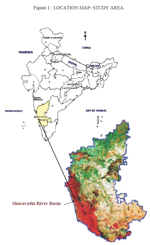
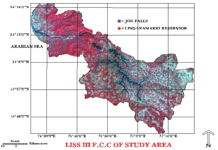
The Sharavathi river originating in the central Western Ghats runs through the districts of Shimoga and Uttara Kannada (Karnataka state, India) and is depicted in Figure 1. The river has a catchment area of about 3600 sq. km (Figure 2). The river, and its tributaries and numerous streams run through the rugged terrain of the Ghats. The river, which takes birth at Ambuthirtha in Thirthahalli taluk flows northwesterly for 130 km to join the Arabian Sea at Honnavar, in Uttara Kannada district. At Jog, the river drops precipitously from a height of 253 m into a deep gorge creating, one of the most spectacular scenic places of the Western Ghats. The major tributaries of the river are, Nandiholé, Haridravathi, Sharmanavathi, Hilkunjiholé, Nagodiholé, Hurliholé, Yenneholé, Mavinaholé, Gundabalaholé, Kalkatteholé, and Kandodiholé.
The river basin has been harnessed for hydroelectric projects to its fullest potential. The Mahatma Gandhi Hydroelectric Project with present installed capacity of 120 MW, was commissioned in 1948. This was followed by Sharavathi Generating Station (1035 MW) commissioned in 1964-65, the Linganamakki Dam Power House (55 MW) and the Sharavathi Tail Race Project (240 MW) at Gerusoppa in 2001. These account for about 45 % of the total installed capacity of hydroelectric power in the state. Sharavathi river alone, in its fullest potential, accounts for an estimated electricity generation of about 6,000 million units (kWh) per annum.
The river water is stored in three major reservoirs, at Linganamakki (14deg 10 24N, 74deg 50 54 E), Talakalale (14deg 11 10N, 74deg 46 55 E) and Gerusoppa (14deg 15N, 74o 39E). The areas submerged for these reservoirs are 326.34, 7.77 and 5.96 sq. km respectively. The Linganamakki reservoir resulted in the full or partial submergence of 99 villages in the Sagar and 76 villages in the Hosanagar taluks of Shimoga district, also causing the displacement of 12000 people. The Talakalale reservoir resulted in the full or partial submergence of 3 villages in the Sagar taluk. Whereas, the Gerusoppa reservoir did not affect any populated village or caused any displacement of humans, but the submergence of 5.96 sq. km of tropical evergreen to semi-evergreen forests. In addition, for the Sharavathi Tail Race project, 4.72 sq. km of forest and 0.08 sq. km of other lands was also acquired for the township, roads, etc.
The current study went a long way in identifying the cumulative environmental impacts of river basin projects. In this regard, the foremost necessity was gathering baseline information on the prevailing ecosystem condition. The outcome of this study, carried out by a multidisciplinary team of scientists and engineers helped in diagnosing the adverse effects of the project on the ecology. This study highlights the need for adopting higher standards in environmental management, which should include conservation, restoration and management strategies for natural ecosystems, like the restitution of corridors of animal migration and improving the quality of aquatic ecosystems and terrestrial ecosystems surrounding the reservoir. The outcome of the study is also a substantial addition to the current benchmark database on existing biodiversity and ecology of the Sharavathi River Valley. The recommendations if implemented properly would certainly help in restoring and conserving the ecosystem in Sharavathi river basin.
The Linganamakki reservoir has a catchment area of nearly 1991 sq.km. It receives water mainly from rainfall and also from the Chakra and Savahaklu reservoirs, which are linked to Linganamakki through a canal. The water from Linganamakki dam flows to Talakalale Balancing Reservoir through a trapezoidal canal with a discharge capacity of 175.56 cumecs. The length of this channel is about 4318.40 m with a submersion of 7.77 sq. km. It has a catchment area of about 46.60 sq.km. The gross capacity of the reservoir is 129.60 cu m.
Due to the hilly terrain, the submergence and consequent increase in water spread area has resulted in creation of several islands distributed throughout the reservoir. There are about around 125 islands with sizes ranging from 2-3 hectares to less than 25 sq. km. In most of the submerged areas the highlands and hilltops protrude out of the water-filled surroundings as islands. During monsoon the water level reaches its peak leaving the top of the hills and hillocks on which the vegetation thrives. However, summer season interconnects the Islands as the water level recedes. The remnants of once inhabited villages that got submerged during construction of the dam can be seen in this region as water level goes down. The entire submersion area is rich in relics of varied kinds which speak of its human habitation once. These relics include temples and idols, asphalted roads , pots and other earthenwares, stone inscriptions etc., lie randomly reminding us of the bygone history and culture. Rows of dead stems of arecanut palms and remains of irrigation channels also surface when the water level goes down, in addition to the diversity of a lot of kinds of trunks of dead trees.