Lake
ecosystems vital functions such as recycling of nutrients, purification of
water, recharge of groundwater, augmenting and maintenance of stream flow and
habitat provision for a wide variety of flora and fauna along with their
recreation values necessitates their sustainable management through appropriate
conservation mechanisms. Failure to restore these ecosystems will result in
extinction of species or ecosystem types and cause permanent ecological damage.
In Bangalore, lakes have played
a prominent role serving the needs of agriculture and drinking water. But the
burgeoning population accompanied by unplanned development has led to the
drastic reduction in their numbers (from 262 in 1976 to 81 at present). The
existing water bodies are contaminated by residential, agricultural, commercial
and industrial wastes/effluents.
Varthur lake is situated in the
south taluk of Bangalore district.
It has a large surface area and is the main irrigation source to the nearby
agricultural fields and supports a wide variety of flora and fauna. The main aim
of undertaking the present study was to evaluate the ecological status of the
Varthur lake, the results of which would help in restoration efforts.
The study consisted of three
parts (i) Morphometric survey to provide the information on the depth,
surface area, width, etc of the lake; (ii) Water quality survey to elucidate
the quality of lake water and the nearby groundwater; (iii) Socio-economic
survey to assess the dependency of the nearby residents on the lake
ecosystem.
The morphometric survey
consisting of depth profiling, contour mapping, volumetric calculations and
other general parameters (surface area,
shoreline, maximum length, maximum width, and mean width) were estimated by
field studies supplemented with GIS software and statistical calculations.
Several physico-chemical parameters of both the lake and nearby groundwater were
analysed according to standard methods of APHA. A random socio-economic survey
was conducted in the nearby villages of Varthur, Baligere and Ramagondanahalli
using a standard questionnaire.
The results of the above studies revealed the following:
(i) The morphometric survey showed that the lake occupies an area of 1 478 000 m2 with a mean depth of 1.05m. The morphometric results emphasise the fact that the whole of Varthur Lake is shallow in relation to its surface area.
(ii) The results of the water quality analysis show that the lake is eutrophic with high concentrations of phosphorous and organic matter. All the parameters analysed were above the standards prescribed for surface waters. The lake was also subjected to faecal contamination. The groundwater analysis did not reveal any contamination by lake water, but further analysis has to be undertaken to rule out the possibility of groundwater pollution.
(iii) The socio-economic aspects of Varthur lake showed that local residents continue to rely heavily on the lake for cattle fodder and irrigation of crops.
The
total land irrigated by the lake water amounts to 1537 acres. Various crops like
paddy, arecanut, bananas, greens, vegetables, flowers and coconuts are grown
using the lake water. There is a possibility that contamination of water
supplies is having a negative effect on the quality and quantity of crops
produced using the lake water. This poses a threat to the primary source of
income for people living near the lake and warrants further investigation.
The results reveal the need and importance for the restoration and management of the Varthur lake. Restoration can be brought about in many ways, the important ones being pollution abatement, desilting of the tank and educating the stakeholders and the local population on the importance for restoring the lake ecosystem. All the conservation measures should have a holistic approach with watershed management practices.
Though, the majority of our
planet is covered by water, only a very small proportion is associated with the
continental areas to which humans are primarily confined. Of the water
associated with the continents, a large amount (more than 99%) is in the form of
ice or groundwater and is difficult for humans to use. Human interactions with
water most often involve fresh streams, marshes, lakes and shallow ground
waters; thus completely relying on a relatively scarce and rare commodity.
Lake ecosystems are one of the
most productive ecosystems in the biosphere and play a significant role in the
ecological sustainability of the region. They constitute an essential component
of human civilization, meeting crucial needs to sustain life on earth, such as
water (agriculture, drinking, etc.), food (protein production, fodder, etc),
biodiversity (diverse flora and fauna), energy (fuel wood, etc), recreation
(tourism), transport, water purification, flood control, pollutant sink and
climate stabilisers. The values of wetlands though overlapping (like cultural,
economic and ecological factors) are inseparable. The geomorphological,
climatic, hydrological and biotic diversity aspects have contributed to wetland
diversity.
Anthropogenic activities
including deforestation, agriculture, and watershed development are known to
affect the input rates of nutrients and organic matter into lakes, often
increasing the overall productivity of lake biota. Lakes are under increasing threat due to the separate, but often
combined impact of identifiable point sources such as municipal and
industrial wastewater, and non-point degradation like urban and agricultural
run-off within a lakes watershed. Major
degrading factors include excessive eutrophication due to nutrient and organic
matter loading; siltation due to inadequate erosion control in agriculture,
construction, logging and mining activities; introduction of exotic species;
acidification from atmospheric sources and acid mine drainage; and contamination
by toxic (or potentially toxic) metals such as mercury and organic compounds
such as poly-chlorinated biphenyls (PCBs) and pesticides. In addition, physical
changes at the land-lake interface (eg. draining of riparian wetlands) and
hydrologic manipulations (eg. Damming outlets to stabilise water levels) have
major impacts on the structure and functioning of these ecosystems.
Lakes have played a
major role in the history of Bangalore serving as an important drinking and
irrigation source. They occupy
about 4.8% of the citys geographical area (640 sq. km) covering both urban
and non-urban areas. Bangalore has many man-made wetlands but has no natural
wetlands. They were built for various hydrological purposes and mainly to serve
the needs of irrigated agriculture. The spatial mapping of water bodies in the
district revealed the number of waterbodies to have decreased from 379 (138 in
north and 241 in south) in 1973 to 246 (96-north and 150-south) in 1996 and 81
at present. This overall decrease of 35% was attributed to urbanisation and
industrialisation (Deepa et.al., 1997). The tanks were reclaimed for various
purposes such as residential layouts, commercial establishments, sport
complexes, etc. Only 30% of the lakes are used for irrigation at present.
Fishing is carried out in 25% of the lakes surveyed, cattle grazing in 35%,
agriculture in 21%, mud-lifting in 30%, drinking in 3%, washing in 36% and
brick-making in 38%. This highlights the need for appropriate conservation,
restoration and management measures.
The following Table
1provides the distribution of tanks by taluks in Bangalore.
Table
1: Talukwise distribution of tanks
|
S no |
Name of the Taluk |
No. of tanks |
|
1 |
Bangalore North |
61 |
|
2 |
Bangalore South |
98 |
|
3 |
Hoskote |
23 |
|
4 |
Anekal |
44 |
|
5 |
Magadi |
11 |
|
6 |
Nelamangala |
13 |
|
7 |
Devanahalli |
12 |
Varthur Lake is an artificial
lake, or tank, located in the
Bangalore South taluk of the Bangalore District in Karnataka. This lake has
played an important role in maintaining water resources for irrigation since its
construction during the Ganga Empire over 1,000 years ago (Karnataka State
Gazetteer, 1990). Over the centuries, it has developed into a complex ecosystem
that provides habitat for a variety of plant and animal species, including
resident and migratory waterfowl. The lake also endows the local community with
a pleasant microclimate and considerable aesthetic appeal.
The lake is surrounded by small
farms that grow rice, raggi, coconut, flowers, and a variety of fruits and
vegetables. The largest town in the immediate area is Varthur, which had a
population of 5,431 as per 1981 census (Census of India, 1981). Several smaller
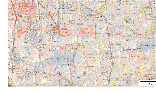
villages are also located near the periphery of the lake. Figure 1.1 presents a
view of southeastern Bangalore and Varthur Lakes catchment area as surveyed
in 1970 to 1974. Human settlements and the roadways are marked in red; the
outskirts of Bangalore city proper can be seen in the upper left-hand corner.
Figure 1.1 Varthur Lake and Surrounding Area
Source:
Survey of India, 1980. Bangalore District. 1st Edition
No. 57 H/9.
Varthur Lake is part of a system
of interconnected tanks and canals that receive virtually all the surface
runoff, wastewater, and sewage from the Bangalore South taluk. Rapid development
and population expansion, both within Bangalore and in the surrounding towns and
villages, have taken a heavy toll on many of the tanks in the area, and Varthur
is no exception. The Bangalore South taluk alone has experienced a surge in its
population from 2,84,556 to 4,45,581 between 1971 and 1981 (Census
of India, 1981). Pollution loading has exceeded the lakes ability to
assimilate contaminants, leading to visible degradation of the quality of water
in the lake. Examining the current ecological status and economic value of the
lake is crucial for developing appropriate remediation strategies. Figure 1.2
presents the interconnectivity of lakes as per the satellite image.
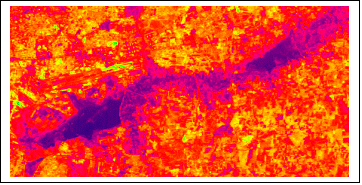
Figure 1.2: Interconnected lakes
The purpose of the study was to identify the most immediate threats to the ecological status of the Varthur Lake and to evaluate the necessity of undertaking restoration efforts in order to maintain the benefits provided by this tank. The results of this study will also provide a base for future analysis of the ecology of the lake and its importance to local residents.
The study was composed of the following components:
§ Morphometric Survey of Varthur Lake, including depth profiling and calculation of volume, to evaluate the risks posed by sedimentation and to provide general morphometric information for future analysis of Varthur Lake.
§ Water Quality Survey of lake water to determine the extent of the pollution in Varthur Lake during the post-monsoon and dry winter seasons and analysis of groundwater to detect potential contamination from lake seepage.
§ Socio-Economic Survey of the stakeholders living in close proximity to Varthur Lake to determine their dependency on the lake, how their use of the lake has changed over time, and their willingness to support restoration efforts.