This study was
carried out on the Bangalore - Mysore highway. Eight taluks straddle the
Bangalore - Mysore highway as well as areas adjacent to these, which have been
influenced by the highway. It includes Mysore taluk of Mysore district,
Srirangapatna, Mandya and Maddur taluks of Mandya district, Channapatna,
Ramanagaram, Bangalore South and Bangalore North taluks of Bangalore district.
This is one of the well-linked regions of Karnataka state and covers an area of
4,152 sq. km with about 1,013 settlements. This segment happens to be one of the
prime urban corridors of the state. The cities like Mysore, Srirangapatna and
Bangalore have been capitals of erstwhile kingdoms and so naturally development
has its effect since historical time. However expansion of Bangalore in recent
times, as a major economic centre with development of industries and commercial
establishments has given impetus to the growth. Early 90's boom in the software
sector with consequent infrastructure initiatives, has contributed to hike in
population, mainly due to migration from other parts of India to Karnataka. The radial sprawl due to Bangalore city's growth is seen
curbing smaller villages on the periphery.
The details of the villages are shown in Appendix D.
The present
investigation analyses the growth pattern within a buffer of 4 km across the
roads connecting Bangalore with Ramanagaram, Ramanagaram with Channapatna,
Channapatna with Maddur, Maddur with Mandya, Mandya with Srirangapatna and
Srirangapatna with Mysore (Figure 1).
During the exploratory survey, it was found that there was a strong presence of
sprawl within a buffer of 4 km around the highway and hence detailed
investigations within a buffer of 4 km around the highway were undertaken.
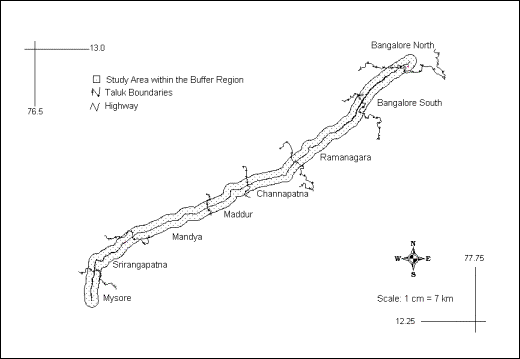
Figure
1: Location of Study Area
This study was
carried out in the region surrounding the highway between Tiruchirapalli,
Tanjavore and Kumbakonam, Tamil Nadu, India (Figure 2). The highway passing
between these cities is the region for detailed investigation. A buffer region
of 4 km on each side is marked as the specific area for thorough investigation.
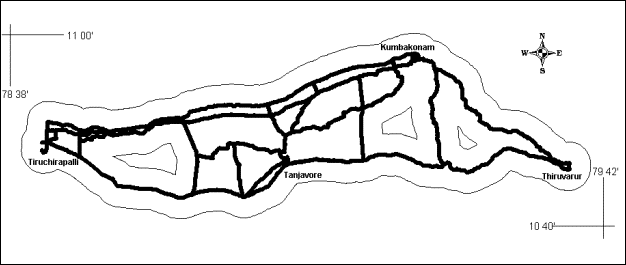
Figure 2: Tiruchirapalli - Tanjavore – Kumbakonam – Thiruvarur with the Road Network
This study was
carried out in the region surrounding the National Highway between Udupi and
Mangalore, Karnataka, India (Figure 3). The National Highway (NH) no. 17 passes
through Mangalore and Udupi. The distance between the two urban centres is 62
km. A buffer region of 4 km on each side is marked as the specific area for
thorough investigation.
The total
study area is 434.2 sq. km. The annual precipitation in this area is
approximately 4242.5 mm in Mangalore and 4128.1 mm in Udupi. The southwest
monsoon during the months of June to October is mainly responsible for the
precipitation. The next round of precipitation occurs in the months of November
and December due to the northeast monsoon. The relative humidity is considerably
high mainly due to the proximity of the region to the coast. Mean annual
temperature ranges from 18.6 o C to 34.9 o C (Census of
India, 1981).
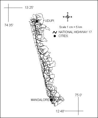
Figure 3: Location of Study Area - Udupi Mangalore Segment
Since the
region is in the coastal zone and the presence of a harbour from a long time,
this region has been one of the major ports of coastal India. The entire region
is very famous for financial institutions and hence has brisk economic activity
as evinced from the growth of cities and infrastructure developments.
Mangalore is the headquarters of Dakshin Kannada district. Until recently Udupi was also in the Dakshin Kannada district, while now it is a new district. There are 39 and 35 villages in Mangalore and Udupi taluks respectively which fall under the study area, the details of which are shown in Appendix E.
| Energy | CES | IISc | Envis | Envis Node |
