The study of urbanisation has evinced interest from a wide range of experts. The multidisciplinary gamut of the subject invokes the interest from ecologists, to urban planners and civil engineers, to sociologists, to administrators and policy makers, and finally the common man. This is because of the multitude of activities and processes that take place in the urban ecosystems everyday. Urban ecosystems are the consequence of the intrinsic nature of humans as social beings to live together. Thus when the early humans evolved they settled on the banks of the rivers that dawned the advent of civilisations. An inadvertent increase in the population complimented with creativity, humans were able to invent wheel and light fire, created settlements and started lived in forests too. Gradually, with the development of their communication skills by the form of languages through speech and script, the humans effectively utilised this to make enormous progress in their life styles. All this eventually led to the initial human settlements into villages, towns and then into cities. In the process humans now live in complex ecosystems called urban ecosystems.
An
unprecedented population growth and migration, an increased urban population
and urbanisation are inadvertent. More and more towns and cities bloomed with
a change in the land use along the myriad of landscapes and ecosystems found
on earth. Today, humans can boast of living under a wide range of climatic and
environmental conditions. This has further led to humans contributing the urban
centres at almost every corner of the earth. These
urban ecosystems are a consequence of urbanisation through rapid industrial
centres and blooming up of residential colonies, also became hub of economic,
social, cultural, and political activities.
To understand the various components and processes that play an important role in the ecosystems are necessary to be understood. This requires a holistic approach dealing with the various components of the ecosystem. Looking back from the formation of the earth, the origin of life and subsequent evolution of life adds more light into the understanding of the current significance of urban ecosystems. The role of scientific and technological innovations in driving the urban ecosystems is an important aspect that is to be considered in the prevalent conditions. The changing lifestyles coupled with rapid urbanisation has also implicated on the material and energy cycles that have a participation in the urban ecosystems apart from the living organisms. Ultimately a clear-cut understanding of the urban ecosystem will enable us to appreciate various life processes and phenomena-taking place. The paradox of the human civilisation today is the inability to appreciate the enormous amounts of biotic and abiotic interactions that play a role in the survival and normal operation of the various ecosystem functions.
In the recent years "sustainable development"
is a commonly used terminology among various sections of the society subsequent
to the publication of Brundtland report in 1987. The Rio 1992, Agenda 21, all
endorsed this need. The sustainable development is defined as, "development
that meets the needs of the present without compromising the ability of the
future generations to meet their own needs" (World Commission on Environment
and Development, 1987). In order to sustain development, the supply and quality
of major consumables and inputs to our daily lives and economic production -
such as air, water, energy, food, raw materials, land, and the natural environment
needs to be taken care of. Land is essential because our food and raw materials
originate from them and is a habitat for flora and fauna. Similar to other resources
it is a scarce commodity. Any disturbance to this resource by way of change
in land use e.g. conversion of forestland, agricultural land into built-up,
is irreversible. The use of land unsuitable for development may be unsustainable
for the natural environment as well as to the humans.
In India, with
an unprecedented population growth and migration, an increased urban population
and urbanisation is inadvertent. More and more towns and cities are blooming
with a change in the land use along the highways and in the immediate vicinity
of the city. This dispersed development outside of compact urban and village
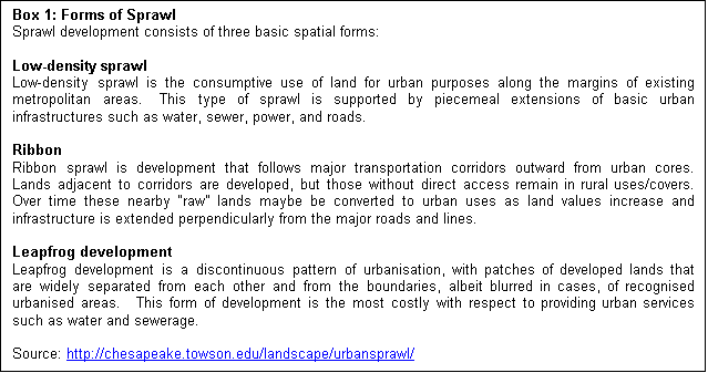
centres along highways and in rural countryside is defined as sprawl (Theobald,
2001). Urbanisation is a form of metropolitan growth that is a response to often
bewildering sets of economic, social, and political forces and to the physical
geography of an area. Some of the causes of the sprawl include - population
growth, economy, patterns of infrastructure initiatives like the construction of
roads and the provision of infrastructure using public money encouraging
development. The direct implication of such urban sprawl is the change in land
use and land cover of the region.
Sprawl
generally infers to some type of development with impacts such as loss of
agricultural land, open space, and ecologically sensitive habitats. Also,
sometimes sprawl is equated with growth of town or city (radial spread). In
simpler words, as population increases in an area or a city, the boundary of the
city expands to accommodate the growth; this expansion is considered as sprawl.
Usually sprawls take place on the urban fringe, at the edge of an urban area or
along the highways.
In
industrialised countries the future growth of urban populations will be
comparatively modest since their population growth rates are low and over 80% of
their population already live in urban areas. Conversely, developing countries
are in the middle of the transition process, when growth rates are highest. The
exceptional growth of many urban agglomerations in many developing countries is
the result of a threefold structural change process: the transition away from
agricultural employment, high overall population growth, and increasing
urbanisation rates (Grubler, 1994). The biggest challenge for science,
engineering and technology in the 21st century is how to ensure adequate
housing, sanitation and health, and transportation services in a habitable urban
environment in developing countries. Sprawl is seen as one of the potential
threats for such development.
Normally, when rural pockets are connected to a city
by a road, in the initial stages, development in the form of service centres
such as shops, cafeteria, etc. is seen on the roadside, which eventually become
the hub of economic activities leading to sprawl.
Eventually a significant amount of upsurge could be observed along these
roads. This type of upsurge caused by a road network between urban / semi-urban
/ rural centres is very much prevalent and persistent in most places in India.
These regions are devoid of any infrastructure, since planners are unable to
visualise this type of growth patterns. This growth is normally left out in all
government surveys (even in national population census), as this cannot be
grouped under either urban or rural centre.
The investigation of patterns of this kind of growth is very crucial from
regional planning point of view to provide basic amenities in these regions.
Further, with the Prime Minister of India's pet project, "Golden
Quadrilateral of National Highways Development Project" initiative of
linking villages, towns and cities and building 4-lane roads, this investigation
gains importance and significance. Prior visualising of the trends and patterns
of growth enable the planning machineries to plan for appropriate basic
infrastructure facilities (water, electricity, sanitation, etc.). The study of
this kind reveals the type, extent and nature of sprawl taking place in a region
and the drivers responsible for the growth. This would help developers and town
planners to project growth patterns and facilitate various infrastructure
facilities. In this direction, an attempt is made to identify the sprawl
pattern, quantify sprawl across roads in terms of Shannon's entropy, and
estimate the rate of change in built-up area over a period with the help of
spatial and statistical data of nearly three decades using GIS.
The process of
urbanisation is fairly contributed by population growth, migration and
infrastructure initiatives resulting in the growth of villages into towns, towns
into cities and cities into metros. However, in such a phenomenon for
ecologically feasible development, planning requires an understanding of the
growth dynamics. Nevertheless, in most cases there are lot of inadequacies to
ascertain the nature of uncontrolled progression of urban sprawls. Sprawl is
considered to be an unplanned outgrowth of urban centres along the periphery of
the cities, along highways, along the road connecting a city, etc. Due to lack
of prior planning these outgrowths are devoid of basic amenities like water,
electricity, sanitation, etc. Provision of certain infrastructure facilities
like new roads and highways, fuel such sprawls that ultimately result in
inefficient and drastic change in land use affecting the ecosystem. With respect
to the role of technology in urbanisation, Berry (1990) has illustrated a new
linkage between transport infrastructure development cycles and spurts in
urbanisation.
Urban
infrastructure development is unlikely to keep pace with urban population
growth. Both local environmental impacts, such as deterioration of water quality
in streams and an increased potential for harbouring disease vectors, and
offsite land cover changes, such as the loss of woodland and forest to meet
urban fuel wood demands, are likely to occur (Douglas, 1994).
Mapping urban sprawl provides a "picture"
of where this type of growth is occurring, and helps to identify the
environmental and natural resources threatened by such sprawls, and suggests the
likely future directions and patterns of sprawling growth. Analysing the sprawl
over a period of time will help in understanding the nature and growth of this
phenomenon. Ultimately the power to manage a sprawl resides with local municipal
governments that vary considerably in terms of will and ability to address
sprawl issues.
GIS and remote sensing are very useful in the
formulation and implementation of the spatial and temporal changes, which are
essential components of regional planning to ensure the sustainable development.
The different stages in the formulation and implementation of a regional
development strategy can be generalised as determination of objectives, resource
inventory, analysis of the existing situation, modelling and projection,
development of planning options, selection of planning options, plan
implementation, and plan evaluation, monitoring and feedback (Yeh and Xia,
1996). GIS and remote sensing techniques are quite developed and operational to
implement such a proposed strategy. The spatial patterns of urban sprawl on
temporal scale is studied and analysed using the satellite imageries and
cadastral data from Survey of India, mapped, monitored and accurately assessed
from satellite data along with conventional ground data. The image processing
techniques are also quite effective in identifying the urban growth pattern from
the spatial and temporal data captured by the remote sensing techniques. These
help in delineating the growth patterns of urban sprawl such as, the linear
growth and radial growth patterns.
Mathematical
models and computational techniques merely increase the capabilities of
generating information that can be used in the decision making process. A model
is a simplified representation of the physical system. Some simplified
definitions of models are - a representative of the system that attempts to
reproduce its significant elements of the system. A model is simply the symbolic
mathematical form in which a physical principle is expressed.
Models are basically built by consideration of the pertinent physical
principles operated on by logic and modified by experimental judgment and plain
intuition.
It is
important to recognise that modeling is a part of science and part of art. The
science part involves identifying the physical principles that affect the
system. The artistic part consists of deciding which of these processes are
sufficiently important with respect to the goals and objectives of the study to
be included in the model and placing the processes in a form that reflects the
interaction involved. The artistic part also involves simplification of the
system so that model solutions can be achieved with a reasonable effort but
without a loss of rationality or accuracy.
Models
synthesise and act as the "glue" between the perception and problem,
the observational data from the laboratory and field, and the current state of
scientific understanding. However, it should always be stressed that modellers
and their models do not make management and control decisions but only provide
information to the process.
The model
should and can reflect the dynamic characteristic and evolutionary nature of the
environment. Its most important function is to establish a basis for a
comprehensive plan of the entire area. Given a set of criteria, the model would
analyse the alternate engineering solutions to achieve this level. Given the
necessary social inputs and constraints, it would be possible to arrive at
optimal solutions between the limits of some acceptable minimal treatment and
maximum technologically practicable treatment. The main objectives of models
are:
|
Descriptive - to integrate observations,
information and theories concerning a system; to aid understanding of
system behaviour. |
|
|
Predictive - to predict the
response of the system to the future changes. |
|
|
Optimised Allocation - to allocate certain resources in order to optimise certain conditions within the system. |
Environmental
modelling as one of the scientific tools for prediction and assessment is well
established in the field of environmental research (Ferda K, 1993).
Environmental modelling has a considerable history and development. The
analytical approaches applied to biological and ecological problems date back to
Lotka-Volterra and the fields like hydrology - water quality modelling also date
back to early twentieth century with Streeter-Phelps. With the enhanced
computational techniques using microcomputers, the numerical solutions to these
have become feasible. There are a variety of models in environmental studies,
which will suit specific situations. For urban growth modelling suitable models
can be used as effective tools in management of urban growth and population
growth leading to land pressures. Depending on the type of method employed in
the construction of equations, the models can be classified into four types –
i.
Analytical Models - These are the models, which
involve construction of solutions of partial differential equations, which
represent the urban systems and the land use changes considered spatially.
ii.
Numerical Models - These are the models in which an
attempt has been made to represent the natural systems and to solve the
equations, which describe the conventional, numerical methods.
iii.
Physical Models - These models involve construction
of physical system at a smaller scale. These types of models are least employed
because of the lack of knowledge of scaling relationships, and thus limitations
experienced in simulating urban growth processes
iv.
Cartographic Models - A cartographic model is a
graphical representation of the data and analytical procedures followed
methodically in a specific study. The purpose of a cartographic model is to help
the analyst organise and structure the necessary procedures as well as identify
all the data required for the analysis.
There are two
basic reasons for constructing representations of urban systems through
mathematical modeling. First is the need to increase the level of understanding
of the cause-effect relationships operative in urban growth dynamics, and
secondly, to apply that increased understanding to aid the decision making
process for the urban growth management.
GIS serves
theoreticians, programmers, and practitioners alike. An understanding of GIS
modeling is important for practitioners who will create the models;
theoreticians, who develop the concepts of new models; and programmers, who must
code to make the models work inside a GIS. The GIS automates geographic
concepts, assists in decision-making, helps explain distributions and can assist
in hypothesis formulation and testing. These tasks can be applied to a wide
range of both practitioners and theoreticians by allowing them to manipulate
portions of the earth that are stored as map data in the computer. The current
popularity of GIS is in the multitude of domains in which they can be applied
and in their ability to automate simple but repetitive map based tasks as well
as complex ones (DeMers, 2002). Especially these tools enable the user to
collate, integrate, analyse and model a large amount of spatial data along with
their attribute information. Harnessing the total potential of the GIS in
environmental modeling rests with the user capable of understanding the concepts
of environmental systems and applications of GIS.
The real world
cannot solely be represented in two dimensions as is commonly accepted. This
certainly is a very limiting view of the reality that we perceive around us.
Most modelling in GIS has been two dimensional especially in the context of
urban planning. The development in the field of "fuzzy logic" and
"artificial neural networks" is providing the option of incorporating
indeterminate and ambiguous information from the real world into GIS. This will
be particularly useful while considering the cognitive models and individual
perception of people and incorporating them for reference into GIS (Agarwal, P.,
2000).
The
main objectives of this study are
|
Identify the patterns of urban
sprawl – spatially and temporally; |
|
|
Analyse the urban sprawl pattern
through remote sensing and geographic information system techniques; |
|
|
Analyse causal factors of urban
sprawl, and |
|
|
Model urban sprawl. |
These
objectives are attained through the following approach:
|
Collateral data: temporal population
data from the government agencies, cadastral data from land records department
and toposheets from Survey of India. |
|
|
Creation of GIS layers: digitisation
of built up area, drainage network and village boundaries from the toposheets
(1972) for the study area. |
|
|
Remote sensing data from National
Remote Sensing Agency, Hyderabad. |
|
|
Geo-correction of remote sensing
data and collection of training data. |
|
|
Application of image processing
techniques (temporal data - remote sensing data) to identify the spatial
changes in built up area over the period. |
|
|
Modelling of these changes (both spatial and temporal). |
| Energy | CES | IISc | Envis | Envis Node |
