|
H.
S. Sudhira
|
|
Centre for Ecological Sciences, Indian Institute
of Science, Bangalore 560 012, India
|
|
T.
V. Ramachandra
|
|
Centre for Ecological Sciences, Indian Institute
of Science, Bangalore 560 012, India
|
|
K.
S. Jagadish
|
|
Department of Civil Engineering, Indian Institute
of Science, Bangalore 560 012, India
|
In India, unprecedented population growth coupled with unplanned developmental activities has resulted in urbanization, which lack infrastructure facilities. This also has posed serious implications on the resource base of the region. The urbanization takes place either in radial direction around a well-established city or linearly along the highways. This dispersed development along highways, or surrounding the city and in rural countryside is often referred as sprawl. Some of the causes of the sprawl include - population growth, economy and proximity to resources and basic amenities. Patterns of infrastructure initiatives like the construction of roads and service facilities (such as hotels, tea shops, etc.) also often encourage the regional development, which eventually lead to urbanization. Identification and analyses of the patterns of sprawl in advance would help in effective infrastructure planning in urban area. In order to estimate and understand the behaviour of such urban sprawls, which is crucial for sound environmental planning and resource management, current study was undertaken along the Mangalore - Udupi National Highway (NH 17).
The pattern of urban sprawl is identified and modeled using remotely sensed data. This helped in identifying the linear and radial pattern of growth and its rate. The analyses involved were land cover, land use, spatial and temporal changes and urbanization growth pattern recognition in a buffer zone of 4 km wide on either side of the highway. The spatial and temporal analyses techniques such as Geographic Information Systems (GIS) and Remote Sensing are used to analyze and interpret the changes in the study region. The cadastral data comprises of the characteristics of land use / land cover, drainage network, roads and railway network and the administrative boundaries of 1972 from the toposheets of scale 1:50,000. Each character was digitized separately as vector layers. The remote sensing data was classified for land use, based on themes - built up, transportation (road and rail network), water bodies (sea, rivers, streams, etc.), agriculture and barren (uncultivable and waste land). For the change detection, temporal data between 1972 and 1999 (IRS platform) were used. This helped to identify the patterns of the change with respect to time.
The entropy approach was applied for quantifying the urban sprawl. Modeling of the sprawl was done considering both spatial and statistical parameters - land use, built-up, watershed, transportation and population. Sensitivity analysis was carried out considering the causal factors and their growth rates. The population growth rate and population density increase, are based on the demographic data for the period 1951- 2001, which is incorporated in the Decision Support System. The decisions were based on various alternatives arising under a given set of criterion for a given objective. These also help to predict the sprawl in the subsequent years.
In India, unprecedented population growth coupled with unplanned developmental activities has led to urbanization, which lacks infrastructure facilities. This also has posed serious implications on the resource base of the region. The urbanization takes place either in radial direction around a well-established city or linearly along the highways. This dispersed development along highways, or surrounding the city and in rural countryside is often referred as sprawl (Theobald, 2001). Some of the causes of the sprawl include - population growth, economy and proximity to resources and basic amenities. Patterns of infrastructure initiatives like the construction of roads and service facilities (such as hotels, etc.) also often encourage the regional development, which eventually lead to urbanization. The direct implication of such urban sprawl is the change in land use and land cover of the region. The ability to service and develop land heavily influences the economic and environmental quality of life in towns (Turkstra, 1996). Identification of the patterns of sprawl and analyses of spatial and temporal changes would help immensely in the planning for proper infrastructure facilities.
Patterns of sprawl and analyses of spatial and temporal changes could be done cost effectively and efficiently with the help of spatial and temporal technologies such as Geographic Information System (GIS) and Remote Sensing (RS) along with collateral data (such as Survey of India maps, etc.). GIS and remote sensing are land related technologies and are therefore very useful in the formulation and implementation of the land related component of the sustainable development strategy. The different stages in the formulation and implementation of a sustainable regional development strategy can be generalized as determination of objectives, resource inventory, analyses of the existing situation, modeling and projection, development of planning options, selection of planning options, plan implementation, and plan evaluation, monitoring and feedback (Yeh and Xia, 1996). GIS and remote sensing techniques are developed and operational to implement such a proposed strategy.
The spatial patterns of urban sprawl over different time periods, can be systematically mapped, monitored and accurately assessed from satellite data (remotely sensed data) along with conventional ground data (Lata et al., 2001). Mapping urban sprawl provides a "picture" of where this type of growth is occurring, helps to identify the environmental and natural resources threatened by such sprawls, and to suggest the likely future directions and patterns of sprawling growth. Ultimately the power to manage sprawl resides with local municipal governments that vary considerably in terms of will and ability to address sprawl issues.
Remote sensing and GIS can be used separately or in combination for application in studies of urban sprawl. In the case of a combined application, an efficient, even though more complex approach is the integration of remote sensing data processing, GIS analyses, database manipulation and models into a single analyses system (Michael and Gabriela, 1996). Such an integrated analyses, monitoring and forecasting system based on GIS and database management system technologies requires an understanding of the problem and the application of available technologies. The integration of GIS and remote sensing with the aid of models and additional database management systems (DBMS) is the technically most advanced and applicable approach today.
Remote sensing applications are growing very rapidly with the availability of high-resolution data from the state of the art satellites like IRS-1C/1D/P4 and LANDSAT. The advancement in computer hardware and software in the area of remote sensing also enhances the remote sensing applications. IRS-1C/1D/P4 provides data with good spectral resolution (LISS data) and the spatial resolution of 5.6 m in panchromatic mode. The remote sensing satellites with high-resolution sensors and wide coverage capabilities provides data with better resolution, coverage and revisit to meet the growing applications needs. The image processing techniques are also quite effective in identifying the urban growth pattern from the spatial and temporal data captured by the remote sensing techniques. These aid in delineating the specific growth patterns of sprawl which could be linear or radial or both.
The physical expressions and patterns of sprawl on landscapes can be detected, mapped, and analyzed using remote sensing and geographical information system (GIS) (Barnes et al., 2001) with image processing and classification. The patterns of sprawl are being described using a variety of metrics and through visual interpretation techniques. Characterization of urbanized landscapes over time and computation of spatial indices that measure dimensions such as contagion, the patchiness of landscapes, fractal dimension, and patch shape complexity are done statistically by Northeast Applications of Useable Technology In Land Use Planning for Urban Sprawl (Hurd et al., 2001; NAUTILUS, 2001). Epstein et al. (2002) bring out the techniques for mapping suburban sprawl. They evaluate the traditional unsupervised classification and proposed GIS buffering approach for mapping the suburban sprawl. They also discuss the problems associated with the classification of urban classes (built-up) in comparison with rural and urban centers.
Yeh and Li (2001) use Shannon's entropy, which reflects the concentration of dispersion of spatial variable in a specified area, to measure and differentiate types of sprawl. This measure is based on the notion that landscape entropy or disorganization increases with sprawl. The urban land uses are viewed as interrupted and fragmented previously homogenous rural landscapes, thereby increasing landscape disorganization. Lata et al (2001) have also employed a similar approach of characterizing urban sprawl for Hyderabad City, India. Pontius et al. (2000) studied the scenarios of land use change in the Ipswich watershed, USA over a period of two decades. This study found that a conversion of forest into residential areas is a predominant land use change. Considering this type of land use change they predict the future land use changes in the Ipswich watershed based on the model calibrated for 1971 and 1985, and validated for 1991. With this model, the extent of deforestation in the watershed is predicted under different scenarios. The results of this are verified by Kappa index.
In recent years, considerable interest has been focused on the use of GIS as a decision support system. The use of GIS as a direct extension of the human decision making process-most particularly in the context of resource allocation decisions is indeed a great challenge and an important milestone. With the incorporation of many software tools to GIS for multi-criteria and multi-objective decision-making - an area that can broadly be termed decision strategy analysis there seems to be no bounds for the application of GIS. The land use changes in the region under different scenarios are done using the multi-criteria evaluation through the decision support system. The decision support is based on a choice between alternatives arising under a given set of criterion for a given objective. A criterion is some basis for a decision that can be measured and evaluated. Criterion can be of two kinds: factors and constraints, and this can pertain either to attributes of the individual or to an entire decision set. In this case the objective being to urbanize; constraints include the already existing built-up area, road-rail network, water bodies, etc., where there is no scope for further sprawl; and factors include the components of population growth rate, population density and proximity to the highway and cities. The decision support system evaluates these sets of data using multi-criteria evaluation. This predicts the possibilities of sprawl in the subsequent years using the current and historical data giving the output images for the objective mentioned. Closely associated with the decision strategy analysis is the uncertainty management. Uncertainty is not considered as a problem with data, but else, it is an inherent characteristic of the decision making process. With the increasing pressures on the resource allocation process, the need to recognize uncertainty as a fact of the decision making process that needs to be understood and carefully assessed. Uncertainty management thus lies at the very heart of effective decision-making and constitutes a very special role in GIS (Eastman, 1999). This paper focuses on the urban sprawl pattern recognition and explores the causal factors.
The main objective of the study was to
These objectives are attained through the following approach:
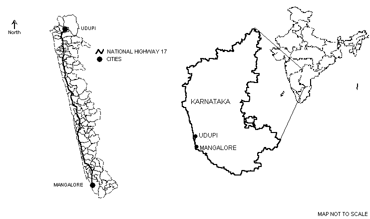
This study was carried out in the region located within coordinates of latitudes 12o 49' 35'' N and 13o 22' 50" N and longitudes 74o 42' 5" E and 74o 54' 55" E surrounding the National Highway between Udupi and Mangalore (Figure 1). The National Highway (NH) no. 17 passes between Mangalore and Udupi. The distance between the two urban centers is 62 km. A buffer region of 4 km on each side is marked as the specific area for thorough investigation.
The total study area is 434.2 sq. km. The annual precipitation in this area is approximately 4242.5 mm in Mangalore and 4128.1 mm in Udupi. The southwest monsoon during the months of June to October is mainly responsible for the precipitation. The next round of precipitation occurs in the months of November and December due to the northeast monsoon. The relative humidity is considerably high mainly due to the proximity of the region to the coast. Mean annual temperature ranges from 18.6o C to 34.9o C (Census of India, 1981).
 |
The data collection was carried out in two phases. This involved primary data collection and secondary data collection. The nature of these data and their source are shown in Table 1.
TABLE 1: PRIMARY AND SECONDARY DATA DETAILS FOR THE STUDY AREA
|
SEGMENT
|
UDUPI MANGALORE
|
SOURCE
|
||||
| PRIMARY DATA |
|
|
||||
|
SECONDARY DATA
|
|
|
The toposheet of 1:50000 used for the current study area has the following features:
- Land use / land cover
- Drainage, water bodies, irrigation systems
- Contours and slopes
- Land geomorphology and soils
- Roads and rail network
- Administrative boundaries
Measuring Urban Sprawl
To understand the complexity of a dynamic phenomenon such as urban sprawl; land use change analyses, urban sprawl pattern and computation of sprawl indicator indices were determined.
The characteristics of land use / land cover, drainage network, roads and railway network and the administrative boundaries from the toposheets were digitised. Individual layers for each character were digitized. The highway passing between the two cities was digitized separately and a buffer region of 4 km around this was created using MAPINFO 5.5. This buffer region demarcates the study region around the highway.
Urban sprawl over the period of three decades (1972-99) was determined by computing the area of all the settlements from the digitized toposheets of 1971-72 and comparing it with the area obtained from the classified satellite imagery for the built-up theme.
The vector layers were digitized from the toposheets of 1972, included themes as; highway in the buffer region, built-up area, drainage (sea, rivers, streams and water bodies), administrative boundaries, and road network.
The toposheets as mentioned in Table 1, were first geo-registered. Since urban sprawl is a process, which can affect even the smallest of villages, each and every village was analyzed. Details of villages like taluk it belongs to, village name, population density, distance to the cities, were extracted from census books of 1971 & 1981 and were added to the attribute database. The area under built-up (for 1972) was later added to this attribute database after digitization of the toposheets for the built-up feature for each village.
Satellite image - IRS data for Path 97 and Row 67 dated 29th March 1999 was procured from NRSA, Hyderabad. From the LISS imagery available the analysis for 1999 was undertaken using Idrisi 32.
The standard processes for the analyses of satellite imagery such as extraction, restoration, classification, and enhancement were applied for the current study. The Maximum Likelihood Classifier (MLC) was employed for the image classification. The original classification of land-use of 16 categories was aggregated to vegetation, built-up (residential & commercial), agricultural lands & open, and water bodies. Area under built-up theme was recognized and the whole built-up theme from that imagery was digitized; this vector layer gave the urban area of 1999. Further, by applying vector analyses, the built-up area under each village was calculated.
Built-up area as an indicator of urban sprawl
The percentage of an area covered by impervious surfaces such as asphalt and concrete is a straightforward measure of development (Barnes et al, 2001). It can be safely considered that developed areas have greater proportions of impervious surfaces, i.e. the built-up areas as compared to the lesser-developed areas. Further, the population in the region also influences sprawl. The proportion of the total population in a region to the total built-up of the region is a measure of quantifying sprawl.
Considering the built-up area as a potential and fairly accurate parameter of urban sprawl has resulted in making considerable hypothesis on this phenomenon. Since the sprawl is characterized by an increase in the built-up area along the urban and rural fringe, this attribute gives considerable information for understanding the behaviour of such sprawls. This is also influenced by parameters such as, population density, population growth rate, etc.
Pattern recognition helps in finding meaningful patterns in data, which can be extracted through classification. Digital image processing through spectral pattern recognition wherein the spectral characteristics of all pixels in an image were analysed. By spatially enhancing an image, pattern recognition can also be performed by visual interpretation.
Shannon's Entropy
As an important exercise, the Shannon's entropy approach (Yeh and Li, 2001) was quantified to detect the urban sprawl phenomenon. The Shannon's entropy, Hn is given by,
Hn = - S Pi log (Pi) .. 1
where; Pi = Proportion of the variable in the ith zone
n = Total number of zones
The value of entropy ranges from 0 to log n. If the distribution is very compact then the entropy value would be closer to 0 and when the distribution is very dispersed the value will be closer to log n. Large value of entropy indicates the occurrence of urban sprawl.
Image Analysis and Interpretation
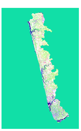
The standard image processing techniques such as, image extraction, rectification, restoration, and classification were applied in the current study. The image obtained from the NRSA in three bands, viz., Band 2 (green), Band 3 (red) and Band 4 (near infrared), were used to create a False Colour Composite (FCC) as shown in Figure 2. Training polygons were chosen from the composite image and corresponding attribute data was obtained in the field using GPS. Based on these signatures, corresponding to various land features, image classification was done using Guassian Maximum Likelihood Classifier.
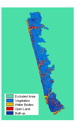
From the original classification of land-use of 16 categories the image was reclassified to four broader categories as vegetation, water bodies, open land, and built-up.
The classified image is shown in Figure 3. From the classified image the area under the built-up theme was computed. Area under built-up theme for each village in the study area was also computed by overlaying a vector layer with village boundaries and tabulated accordingly for further analyses.
|
Figure 2 False Colour Composite |
Figure 3 Classified Image |
Table 2: Built-up Area, Population and Shannons Entropy for the Study Area
|
Segment |
Built-up Area (sq. km) |
Population |
Shannons Entropy |
||||
|
1972 |
1999 |
1972 |
1999 |
1972 |
1999 |
log N |
|
|
Udupi - Mangalore |
25.1383 |
61.7603 |
312003 |
483183 |
1.7673 |
1.673 |
1.9138 |
Population Growth and Built-up Area
The rate of development of land in the region of Udupi - Mangalore is far outstripping the rate of population growth. This implies that the land is consumed at excessive rates and probably in unnecessary amounts as well. Between 1972 and 1999, population in the region grew by about 54% (Census of India, 1971 and 1981) while the amount of developed land grew by about 146%, or nearly three times the rate of population growth. (Figure 4) This means that the per capita consumption of land has increased markedly over three decades. The per capita land consumption refers to utilization of all the land development initiatives like the commercial, industrial, educational, and recreational establishments along with the residential establishments per person. Since most the initiatives pave way for creation of jobs and subsequently helps in earning livelihood, the development of land is seen as a direct consequence of this and hence one can conclude that the per capita land consumption is inclusive of all the associated land development.
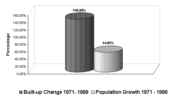
Figure 4 Rates of Growth in Population and Built-up from 1971 - 1999
Shannon's entropy was calculated from the built-up area for each village wherein each village was considered as an individual zone (n = total number of villages). From the Shannon's entropy calculation, it revealed that the distribution of built-up in the region in 1972 was more dispersed than in 1999. However the degree of dispersion has come down marginally and that distribution is predominantly dispersed or there is the presence of sprawl. It should be recollected that the entropy value indicates the degree of dispersion or compaction of the built-up in the region. The values obtained here being 1.7673 in 1972 to 1.673 in 1999, are closer to the upper limit of log n, i.e. 1.914, thus showing the degree of dispersion of built-up in the region.
URBAN SPRAWL MODELING
In the recent years, a lot of thrust in this field has been to understand and analyze the urban sprawl pattern. Various analysts have made considerable progress in quantifying the urban sprawl pattern (Theobald, 2001; Lata et al, 2001; Torrens and Alberti, 2000; Batty et al, 1999; Barnes et al, 2001). However all these studies have come up with different methodologies in quantifying sprawl. The common approach is to consider the behaviour of built-up area and population density over the spatial and temporal changes taking place and in most cases the pattern of such sprawls is identified by visual interpretation methods.
Defining this dynamic phenomenon with relative precision and accuracy for predicting the future sprawl is indeed a great challenge to all working in this arena. One of the basic and major challenges is the quantification of such sprawls. Although different sprawl types were identified and defined there has been an inadequacy with respect to developing mathematical relationships to define them. Further as if aggravating this problem, much of the work related to studying dynamics of urban sprawl are not carried out in the developing countries, except a few. Thus giving very little relevance to correlate the available findings in the context of developing countries. However the negative impacts of such urban sprawls in the developing countries is more severe and intense compared to that of developing countries. Typically, the developing countries are faced with an unprecedented population growth and potentially threatened vast natural resources. In such a scenario, it is definitely an exacting effort to study, characterize and model the urban sprawl phenomenon in the context of developing countries. This paper is an attempt in such exploration of understanding the urban sprawl phenomenon, pattern recognition and modeling studies as well.
The causal factors affecting the urban sprawl pattern were analysed. For the analyses, the causal factors that were considered responsible for sprawl were:
The percentage built-up is the proportion of the built-up area to the total area of the village. The a population density (POPADEN) is the proportion of the population in every village to the built-up area of that village. The b population density (POPBDEN) is the proportion of population in every village to the total area of that village. The b population density is often referred as population density. Since the built-up area plays an important role in the current study for the purpose of analyses, the percentage built-up, a and b population densities are computed and analyzed village-wise and categorized as a sub-zone. The distance from the city centers, viz. Udupi and Mangalore to each village were calculated. Thus the effect of proximity of the cities on the urban sprawl of these sub-zones were analyzed by regression analyses with the parameter percentage built-up (PCBUILT) as dependent variable. The causal factors / parameters of urbanization such as population, a and b population densities, etc. were the independent variables (Table 3).
Table 3 Correlation coefficients among causal factors and percentage built-up by linear regression analyses
|
Dependent Variable (Y) |
Independent Variables (X) |
Equation |
% Error |
Correlation Coefficient (r) |
|
pcbuilt |
pop99 |
Y = 0.000611 X + 10.87149 |
4.77 |
0.2966 |
|
pcbuilt |
popaden |
Y = - 0.0004 X + 19.5719 |
3.24 |
0.3727 |
|
pcbuilt |
popbden |
Y = 0.005774 X + 7.849476 |
0.046 |
0.3350 |
|
pcbuilt |
mangdist |
Y = - 0.31149 X + 22.93755 |
2.55 |
0.3965 |
|
pcbuilt |
udupidist |
Y = 0.315763 X + 5.584017 |
2.58 |
0.4070 |
The linear regression analyses revealed that the distance from urban centers (such as UDUPIDIST and MANGDIST) play a significant role in the sprawl phenomenon.
Multiple variable regression analysis was done to assess the cumulative effect of causal factors (except POPADEN) and the probable relationship is,
PCBUILT = - 11.7781 + 0.000417*POP99 + 0.001844
POPBDEN + 0.252492*MANGDIST + 0.543125*UDUPIDIST . . 2
The correlation coefficient being, r = 0.503.
Multiple variable analyses (leaving out POP99) revealed,
PCBUILT = - 13.0645 + 0.004476*POPBDEN + 0.275183*MANGDIST + 0.546952 *UDUPIDIST .. 3
The correlation coefficient being, r = 0.485.
Predicting the Scenarios of Urban Sprawl
The causal factors and set of constraints were considered for predicting the scenarios of urban sprawl. Considering the decadal population growth rates from 1961-2001, the population of the village was projected for 2051 and 2101. Using population of 2051 and 2101 (POP51 & POP01), the new POPBDEN51 & POPBDEN01 were calculated. Thus, substituting the values of POPBDEN51 and POPBDEN01 in Equation 3, the relationship is,
PCBUILT = - 13.0645 + 0.004476*POPBDEN51 + 0.275183*MANGDIST + 0.546952 *UDUPIDIST 4
PCBUILT = - 13.0645 + 0.004476*POPBDEN01 + 0.275183*MANGDIST + 0.546952 *UDUPIDIST 5
Using the relationships 4 and 5, it was found that the percentage built-up for 2051 and 2101 would be 17.55 % and 20.53 % respectively. This indicates that the pressure on land would continue to increase as ever and the agriculture fields, open grounds and water bodies would become prime targets for sprawl. With an understanding of the land requirement under the current trend the techniques of GIS and RS can be applied for effective infrastructure facilities and resource utilization.
The urban sprawl over a period of nearly thirty years was quantified in terms of the change in built-up area as well as Shannon's entropy index. The percentage change in built-up (145.68%) was found to be very much higher than the percentage change in population growth (54.05%).
Further the thrust being on the modeling studies, the study successfully defines the sprawl phenomenon with respect to mathematical relationships. From these the possibility of sprawl in terms of percentage built-up were estimated for 2051 and 2101. The future scope of this work would look into generating the images of further sprawl under different scenarios to understand any threat to natural resources and ecosystem. This endeavor demonstrates the application of GIS and RS techniques in studying urban sprawl and its dynamics.
With the development and infrastructure initiatives mostly around the urban centers, the impacts of urban sprawl would be on the natural resources and ecology. The wisdom lies in how effectively we plan the urban growth without hampering the natural resources and disturbing the rural setup. But else, the planning should also focus on a dispersed economic structure and aim at creation of balanced ecological, social, and economic system.
We thank ISRO - IISc Space Technology Cell for financial assistance to carry out field investigations and NRSA, Hyderabad for providing the satellite data required for the study. We are grateful to Ministry of Environment and Forests, Government of India and Indian Institute of Science for infrastructure support.
Barnes K. B., Morgan III J. M., Roberge M C., and Lowe S, 2001. "Sprawl development: Its patterns, consequences, and measurement", Towson University.
Available online: http://chesapeake.towson.edu/landscape/urbansprawl/download/Sprawl_white_paper.pdf
Batty M., Xie Y., and Sun Z., 1999. "The dynamics of urban sprawl", Working Paper Series, Paper 15, Centre for Advanced Spatial Analysis, University College London.
Available online: http://www.casa.ac.uk/working_papers/
Census of India, 1971. "District Census Handbook South Kanara District" Series 14, Mysore, Directorate of Census Operations.
Census of India, 1981. "District Census Handbook Dakshin Kannada District" Series 9, Karnataka, Directorate of Census Operations.
Epstein, J., Payne, K., and Kramer, E., 2002. "Techniques for mapping suburban sprawl", Photogrammetric Engineering and Remote Sensing, Vol. 63(9): pp 913 918.
Eastman, J. R., 1999. Idrisi32: Guide to GIS and Image Processing, Volume 1 & 2, Clark Labs, Clark University, USA.
Hurd, J. D., E. H. Wilson, S. G. Lammey, and D. L. Civeo. 2001. Characterization of forest fragmentation and urban sprawl using time sequential Landsat Imagery. Proceedings, ASPRS Annual Convention, St. Louis, MO. April 2327, 2001.
Available online: http://resac.uconn.edu/publications/tech_papers/index.html
Lata K. M., Sankar Rao C. H., Krishna Prasad V., Badrinath K. V. S., Raghavaswamy, 2001. "Measuring urban sprawl: a case study of Hyderabad", GISdevelopment, Vol. 5(12).
Michael, F. B., and Gabriela, M. A., 1996. "Remote sensing and geographic information systems", Hydrological Sciences, Journal des Sciences Hydrologiques, Vol. 41(4): pp 593 607.
Nautilus. 2001. Characterization of Urban Sprawl.
Available online: http://resac.uconn.edu/research/urban_sprawl/index.htm
Pontius Jr, R. G., Claessens, L., Hopkinson Jr, C., Marzouk, A., Rastetter, E. B., Schneider, L. C., Vallino, J., 2000. "Scenarios of land-use change and nitrogen release in the Ipswich watershed, Massachusetts, USA", Paper presented at 4th International Conference on Integrating GIS and Environmental Modeling (GIS/EM4): Problems, Prospects and Research Needs. Banff, Alberta, Canada, September 2 - 8, 2000.
Theobald, D. M., 2001, "Quantifying urban and rural sprawl using the sprawl index", Paper presented at the annual conference of the Association of American Geographers in New York, on March 2nd, 2001.
Torrens P. M., and Alberti M., 2000. "Measuring sprawl", Working paper no. 27, Centre for Advanced Spatial Analysis, University College London.
Available online: http://www.casa.ac.uk/working_papers/
Turkstra J. 1996. Urban growth and land use options for lower-income groups: a case study of Villavicencio, Columbia. ITC Journal, 1996-1: pp. 57 63.
Yeh, A. G. O., and Xia Li, 1996. Urban growth management in the Pearl river delta: an integrated remote sensing and GIS approach. ITC Journal, Special Habitat-II issue, 1996 - 1: pp. 77-86.
Yeh, A. G. O., and Xia Li, 2001. "Measurement and Monitoring of Urban Sprawl in a Rapidly Growing Region Using Entropy", Photogrammetric Engineering and Remote Sensing, Vol. 67(1): pp 83.
internet resources on urban sprawl:
http://www.sierraclub.org/sprawl/
http://www.vtsprawl.org/casestudies.htm
http://www.osc.edu/education/webed/Projects/urban_sprawl/