|
Free and Open Source Software (FOSS) is liberally licensed to grant the right of users to study, change, and improve its design through the availability of its source code. It has more scope for being available in multiple languages and for being adapted or tweaked to particular needs. FOSS enable users to freely copy and distribute the software. This option benefits students, researchers, teachers and scientists wanting to use legal software appropriate for their needs with modest budgets. FOSS has gained both acceptance and momentum in India and worldwide as the potential benefits have been increasingly recognized globally. Open source software are those, for which the human-readable source code is made available under a copyright license (or arrangement such as the public domain) that meets the Open Source Definition (http://www.fsf.org/). Copyleft such as (GNU General Public License) is a form of licensing and may be used to modify copyrights for works such as computer software, documents, etc. It also allows reproducing, adapting or distributing the work.
Over the last decade, the paradigm of FOSS development has made strides in the GIS arena, resulting in the creation of several very sophisticated GIS software projects for numerous purposes. FOSS for Geoinformatics aids in studying the variation in landscapes over multiple spatial and temporal scales encompassing a variety of research, such as land use and land cover change, climate change, water resources, urban development, natural disaster mitigation, etc. FOSS GIS are increasingly being used as the principal tool for such digital exploration of variation in landscapes, as they provide the necessary functions for spatial data collection, management, analysis and representation. Among the many GIS tools that are frequently used, Desktop GIS, Mobile GIS, Remote Sensing and Image Processing software, GIS extensions and libraries, Spatial Database Management Systems, Mapserver and Geostatistical tools are the most commonly used that facilitate customisation, provide good support via forums and email lists and have up-to-date documentation. OSGeo-Live is a self-contained bootable DVD, USB thumb drive or Virtual Machine based on Xubuntu that allows a wide variety of open source geospatial software without installing anything. It provides pre-configured applications for a range of geospatial applications, including storage, publishing, viewing, analysis and manipulation of data
(http://live.osgeo.org/en/index.html). FOSS avoids reinventing the wheel and allows adaptation without restrictions. In addition to these general research advantages, the use of FOSS licenses can enhance education and knowledge transfer, particularly in developing countries that don't have the (financial) resources. Students can freely and legally download the software and study the algorithms. Finally it benefits society in general, as the use of free software licenses can facilitate the application of new technologies and knowledge that enables a sustainable use of resources. If such unified software development and research efforts could be initiated then we see great potential to accelerate Geoinformatics research world wide.
GRDSS (Geographic Resources Decision Support System) based on GRASS GIS (http://wgbis.ces.iisc.ac.in/grass) is one such FOSS GIS that aids in data management, image processing, graphics production, spatial modeling and visualisaiton (http://wgbis.ces.iisc.ac.in/foss).
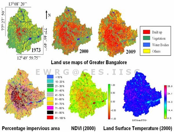
Case study: Bangalore is one of the fastest growing cities in Asia and is experiencing unprecedented urbanisation and sprawl in recent times due to concentrated developmental activities with impetus on industrialisation for the economic development of the region (http://wgbis.ces.iisc.ac.in/energy/water/paper/P25_1/index.htm). This concentrated growth has resulted in the increase in population and consequent pressure on infrastructure, natural resources, ultimately giving rise to a plethora of serious challenges such as climate change, enhanced green-house gases emissions, lack of appropriate infrastructure, traffic congestion, and lack of basic amenities (electricity, water, and sanitation) in many localities. A study was carried out using multi-resolution remote sensing data using GRDSS which showed 632% urban growth across 37 years (1973 to 2009). Urban heat island phenomenon is evident in large number of localities with higher local temperatures with an increase of 2 to 2.5 ºC. The natural resources such as vegetation declined by 76% and water bodies reduced by 79%, necessitating appropriate strategies for the sustainable management (http://wgbis.ces.iisc.ac.in/energy). Urbanisation and the consequent loss of vegetation and water bodies have led to the decrease in catchment yield, water storage capacity, wetland area, number of migratory birds, flora and fauna diversity and ground water table. As land is converted from agricultural to impervious surface, it loses its ability to absorb rainfall. The relationship between land surface temperature and NDVI investigated through the Pearson’s correlation coefficient at a pixel level and the significance tested through one-tail Student’s t-test, confirmed the relationship for all land use types. The urban growth poles are towards north, northeast, south and southeast of the city indicating intense urbanisation process due to growth agents like setting up of Information Technology and Biotechnology corridors, industrial units, etc. Newly builtup areas in these regions consisted of maximum number of small-scale industries, software companies, multistoried building and private houses that came up in the last two decades. The growth in northern direction is attributed to the new Bangalore International Airport, encouraging other commercial and residential hubs.
Useful links:
|
