
Mega-Regional Development and Environmental Change in China and India

|
Mega-Regional Development and Environmental Change in China and India |
|
 |
||||||
Jefferey M. Sellers, Bharath Aithal, Huang Jingnan, B. Uttam Kumar, Mingjun Peng, T. V. Ramachandra and Liu Yong | ||||||
Citation: Jefferey M. Sellers, Bharath Aithal, Huang Jingnan, Uttam Kumar, Mingjun Peng, T. V. Ramachandra and Liu Yong, 2015. Mega-Regional Development and Environmental Change in China and India [ARCP2013-22nMY-selleRs], APN Science Bulletin, Issue 4, March 2014, Pp 116-118 |
| Summary |
Urbanisation in Asia and elsewhere in the developing world represents one of the largest anthropogenic global shifts ever to take place, with major crosscutting implications for land use, biodiversity, greenhouse gas (GHG) emissions and human welfare. Worldwide, the largest proportion of urban growth in the coming decades will occur in China and India. This project examines the increasingly important dynamics of urbanisation beyond the largest urban agglomerations and their immediate peripheries, and the consequences for land use and the environment
Thus far, research on urban dynamics and their consequences has focused mainly on individual cities and metropolitan areas (e.g., Angel et al., 2005; Schneider & Woodcock, 2008). Throughout the developing world, however, urban growth increasingly clusters in wider areas beyond the bounds of individual metropolitan regions. Reflective of long-standing trends in developed countries, diffuse or distributed patterns of urbanisation more have emerged across large scale regions or transportation corridors of 100,000 km2 (Florida et al., 2008; Seto et al., 2012). Policy choices in domains from economic development, planning and infrastructure to migration often shape these dynamics. As regional dynamics beyond the largest urban centres play out in areas of institutional fragmentation and limited governmental capacities, an array of new challenges for policy-making and governance has emerged. Dynamics at this wider regional scale are especially critical to the cumulative environmental consequences from urbanisation, such as land degradation, increasing GHG emissions and loss of biodiversity
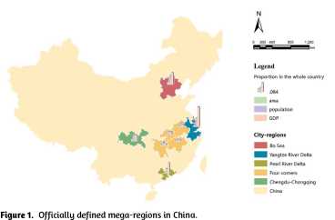
Mega-regional development is common to both India and China, but major national institutional, economic and social differences shape its dynamics. Chinese local governments possess institutional instruments and resources to shape urban growth that Indian local governments usually lack, but that can also undermine the sustainability of developmental trajectories. China has also recently introduced cooperative planning among governments at the inter-urban scale of mega-regions (Figure 1) that so far has no parallel in India. National differences in an array of legal rules and planning practices, as well as other related policies such as residency requirements, further affect the course of urbanisation. An earlier APN project undertaken by the same team, including a comparative study of urban form in ten cities of each country, showed that the dynamics of peri-urban land expansion and urban form have diverged systematically between the two countries (Ramachandra et al.,
2012; Sellers et al., 2013a, 2013b). This project employs remote sensing images and GIS to examine mega-regional dynamics and their consequences at both the macroscale and microscale in four emerging Chinese and Indian regions. The study will examine several interrelated topics such as: (1) large-scale regional dynamics of urban development; (2) policy, economic and institutional sources of variations in trajectories of mega-regional development; (3) the effects of these variations on regional environmental change; and (4) based on projections of future developmental trajectories and their consequences, future policies to address the dynamics and the environmental consequences from regional trajectories of urban development. A nested research design will combine region-wide spatiotemporal analysis of urban form and land-use change with matched cases of urbanising corridors and micro-level analysis of particular localities or districts within each mega-region. Groundwork for the project has begun prior to its commencement in early 2014 (Aithal et al., 2013; Ramachandra et al., 2013). Project activities will run until early 2016. Analyses will focus on the patterns of urbanisation from 1990 to the present in mega-regions emerging around Chennai, Bangalore and Mangalore in South India, around Mumbai and Pune in Central India, in the Pearl River
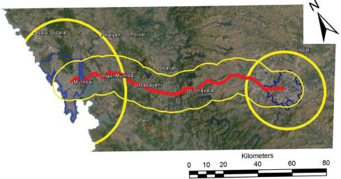
Figure 2. Study area for analysis of urban corridor between Mumbai and Pune.
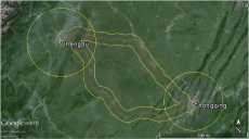
Figure 3. Study area for analysis of urban corridor
between Chengdu and Chongqing.
Delta of China, and around Chengdu and Chongqing in Western China. Standardised protocols for defining boundaries and analysing remote sensing and other data will incorporate identical definitions of boundaries and image processing procedures in each country. This will enable side by side comparison of mega-regional dynamics in such matched contexts as the urbanising corridors between large cities of each country (Figures 2 and 3). At least four or five papers are scheduled to be published from the project. A volume is planned that will synthesise analyses and findings from this project and the previous one
| References |

| E-mail | Sahyadri | ENVIS | Energy | GRASS | CES | IISc | E-mail |