| Back | 5.1 | 5.2 | 5.3 |
Ecological status assessment involved the investigations of both terrestrial and aquatic ecosystems. Table 5 lists the major components and methods used in the study.
Table 5. Methods used in Ecological status assessment of SVWS. |
|
| Terrestrial Ecosystem | |
i. Land-cover and Land-use Analysis
|
Slope based VI has been attempted depending on the extent of vegetation cover in the region for the land-cover analysis. Land-use analysis for eight categories was done using maximum likelihood classifier. |
ii. Vegetation Composition |
Transect cum quadrats method was used for sampling. The diversity indices, tree basal area, IVI, % evergreen, and % endemics have been calculated. The regeneration status of trees (based on girth classes) has been computed. |
iii. Faunal Distribution. |
Opportunistic sampling has been carried for species composition and distribution. |
| Aquatic Ecosystem | |
i. Phytoplankton |
Sampling has been carried out using phytoplankton net of mesh size 63 m m (bolting silk net No.25) in the reservoir area of the sanctuary. |
ii. Zooplankton |
Sampling has been carried out using plankton net with mesh size 50 µm and 75 µm in the reservoir area of the sanctuary. |
iii. Ichthyofauna |
Sampling has been carried out with the help of fishermen, using devices such asgill nets, and hooks and lines. The nets of varying mesh sizes (2 cm ´ 2 no., 5 cm ´ 2 no., and 12 cm ´ 1 no.) were used and laid in an approximate area of 200 ´ 200 sq.m. The lengths of the nets were maintained to 100 metres. The nets were laid in the evenings and early in the morning they were removed. The total duration of netting is 12-14 hours, complying with the routine practices of the fishermen. Shallow streams were sampled using cast net and dragnets. |
| iv. Amphibians | Time constrained samplings were carried out (2x2 person-hours) from 17:30 to 19:30 hrs. During the survey, amphibians were searched using torchlight and also based on their vocal calls. |
| Humans | |
i. Socio-Economic-Energy Studies |
Questionnaire based sampling has been carried out. |
| 5.1 Terrestrial Ecosystems | 5.1 | 5.2 | 5.3 |
5.1.1 Land-Cover and Land-Use Analysis
Land-cover and land-use determines vegetation of a region. These in turn help in understanding the natural resources, hydrological cycles and associated biodiversity pattern that are important in formulating conservation and management strategies. Land-cover refers to the predominating physical feature on the surface of the land such as vegetation and non-vegetation, whereas land-use refers to the particular usage (from human perspective) of the land viz., built-up, agricultural land, open land, forest land, etc. Land-use change analyses help to understand (i) the driving forces (exogenous variables) of land-use as they operate through the land manager; (ii) the land-cover implications of land-use; (iii) the spatial and temporal variability in land-use/cover; and (iv) impacts on biodiversity and ecosystem functioning.
Vegetation index (VI) was used to determine the land-cover (vegetation against non-vegetation). Red and near infra red (NIR) wavelengths of electromagnetic spectra behave analogous to a vegetated region. There is a strong absorption in the region of 0.6-0.7 µm in a vegetated area that corresponds to red band, where as due to the internal structure of the leaves, 0.7-0.9 m m of near infrared is highly scattered and reflected back. Based on this contrasting nature of red and near infrared, which helps in delineating vegetation and non-vegetation areas, VI was calculated to analyse vegetation pattern.
Slope based VI was computed depending on the extent of vegetation cover in the region for the land-cover analysis. Slope based VI was adopted for regions with good vegetation i.e. western part of the study area where soil reflection is very less because of dense canopy covers.
The principle behind slope-based VI is the contrast between the red and near infrared spectra to the vegetation. The values indicate both the status and abundance of green vegetation cover and biomass. Normalised Difference Vegetation Index (NDVI) has the ability to minimise topographic effects in any vegetated area while producing a linear measurement scale and is given by
![]()
It ranges from 1 to 1, the negative value represent non-vegetated area (like soil, water, etc.), while positive values represent vegetated area (forests, agriculture, plantation, etc.).
Land-use analysis for seven categories was done using maximum likelihood classifier. This classification is based on probability density function associated with a particular signature (training site). Pixels are assigned to most likely class based on a comparison of the posterior probability that it belongs to each of the signatures being considered.
The landscape in this region is a mosaic of a variety of elements, which are caused by human impacts through historical times to current period. A preliminary examination or reconnaissance of the study area was made to get a general picture of the landscape and its vegetation. Regional and topographic maps and survey maps were procured to assist in determining access routes, topographic obstacles, study of onsite features, and for spatial analysis (GIS-Geographic Information System). In reconnaissance survey, the place has been traversed rapidly and following features are indicated:
• Major vegetation patterns and plants communities, including their growth forms and dominant species.
• Correlation between plant communities and features such as topography, geology, soil and water.
• Past and present human influence on the vegetation.
• Identification of unknown plants was done either in the field or the plant materials were collected for later determination. Herbarium is prepared in needy cases.
Data Collection
Primary data collection in representative sample plots was based on both qualitative and quantitative assessments. The frequency and number of the species present in different quadrat samples assess species abundance and diversity. Secondary data collection, which includes the preparation of species list (Phytoplankton to higher plants) occurring in the study area, has been done by site visits and by consulting published literature.
The natural vegetation ranges from the climax tropical evergreen to semi-evergreen forests along the high rainfall areas of the main hill ranges of the Western Ghats to the moist deciduous forests in the undulating plains and low hills along the eastern drier tracts of the river basin. The vegetation was studied in 41 randomly chosen localities in the sanctuary.
Sampling Methods
A transect based quadrat method was used for vegetation sampling. A total of 41 transects cum quadrats, accounting for 201 quadrats were sampled. The transect length ranged between 120 to 180 m. Maintaining uniformity in transect length was difficult in view of the patchy nature of vegetation and undulating terrain. However, in extreme cases, as in small islands and very large homogenous patches, transect length was deviated from the general range. Quadrats of 20 X 20 m area were laid along the transect, alternating on either side at intervals of 20 m, as shown in Figure 2. Table 6 lists the parameters recorded in quadrats.
Table 6. Parameters recorded during sampling. |
||||||
| Sl. No. | Species name | GBH (cm) | Height (m) | Phenology | Climbers | Remarks |
Using Global Positioning System (GPS) the latitude and longitude values of the quadrat positions were noted. Any special observations like sighting epiphytes, parasites, unusual branching patterns, etc. were noted in the remark column.
Figure 2. Typical transect with quadrats, A - 20m x 20m for trees; B - 5m x 5m for shrub layer; C - 1m x 1m herbs/herb layer.
Sampling of Trees
In each quadrat, height and girths of all the trees [having = 30 cm girth at breast height (gbh) or at 1.30 m above the ground] were recorded. The approximate height of tree was estimated in metres. The climbers and epiphytes associated with trees were noted.
Ground Vegetation sampling
Shrub layer: The ground layer of plants (+1 m height and higher but GBH < 30 cm) was sampled using two sub-quadrats of 5 X 5 m each, located within the tree quadrat, as shown in Figure 2. Tree saplings and shrubs as well as tall herbs were enumerated in these 25 m 2 sub-samples.
Sampling of herbs/herb layer: Within the 5 X 5 m sub-quadrats, two quadrats of one square meter each were placed as shown in Figure 2 for sampling the diversity of herb layer (plants less than 1 m height). The herb layer included lower plants like the pteridophytes, herbs, shrubs, juvinles of climbers as well as tree seedlings.
Estimate of Canopy Cover
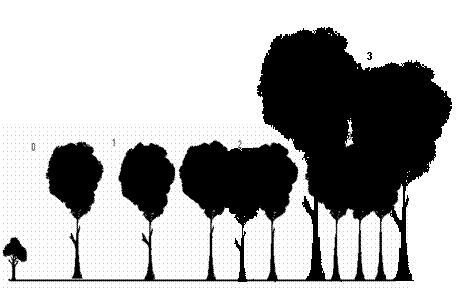
Multi-layered canopy structure is greatly significant in forest ecology, such as in breaking the force of the torrential tropical monsoon rains, in preventing soil erosion, in maintaining humidity and shade, in matters connected to water percolation into the soil and stream flow, etc. Within each tree quadrat of 20 m 2 the nature of canopy cover was observed at 5 points and ranked as 0, 1, 2 and 3 as shown in Figure 3. Mean value of the 5 points was taken as the canopy for respective quadrat.
Figure 3. Gradation of forest canopy.
Description of the Study Localities
The following additional details were recorded from each sampled locality.
• Location: Local name of the locality surveyed, hamlet, village, taluk, forest beat and forest range.
• Patch type: Evergreen, semi-evergreen, moist-deciduous, scrub, etc.
• Legal status.
• Transect number, Transect length.
• Nature of the terrain: steep slope/moderate/low to flat/undulating.
• The occurrence of a stream associated with the site.
• Rock outcrops or rockiness: high/moderate/poor to nil.
• Nature of rocks: lateritic/non-lateritic.
• Soil erosion on the site: high/moderate/least.
• Nearest human habitation (distance).
• Notes on human interference viz., lopping, tree cutting, burning, fuel extraction, litter collection, cattle grazing and any other activities.
• Sacred value.
• Non-Timber Forest Produce (NTFP) collection.
Ecological Measurements
A number of basic measurements are used in describing population and communities. Among these are density, frequency, coverage and biomass. Other important ecological measurements such as population distribution, species diversity and productivity are made from these.
Diversity is an indicator of status of an ecosystem. It consists of two components, the variety and the relative abundance of species. The higher value indicates higher diversity. Diversity was estimated using the Shannon-Weiner and Simpson methods. Various indices that were used in the biodiversity studies, which include both flora and fauna, have been listed in Table 7.
Table 7. Diversity parameters and indices used in the study. |
|||
Index |
Equation |
Remarks |
References |
| Density | Number of species A /
Area sampled (m2) |
Compactness with which a species exists in an area. | Elzinga et al., (2001) |
| Relative Density | Density of species/ A x 100 Total density of all species | ||
| Dominance | Basal area of species A / Area sampled (m2) | The occupancy of a species over an area | |
| Relative dominance | Dominance of species/ A x 100 Total dominance of all species | ||
| Frequency | Number of quadrats with species A/ Total number of quadrats sampled | The repeated occurrence of a species | Elzinga et al., (2001) |
| Relative Frequency | Frequency of species / A x 100 Total frequency of all species | ||
| Important Value Index | R. density + R. frequency + R. basal area | ||
| Abundance | Number of individuals of a species x 100/ Number of sampling units | ||
| Numerical Species richness | |
It is the numerical estimation of species richness dependent on sample size. But it completely ignores the composition and misses information of rare and commonness of a species. | Margalef (1958), Ludwig and Reynolds (1988) |
| Shannon Weiner's | The value ranges between 1.5 and 3.5 and rarely surpasses 4.5. | Ludwig and Reynolds (1988); Legendre and Legendre 1998 | |
| Simpson's |  |
The value varies from 0 to 1. A value of 0 indicates the presence of only one species, while 1 means that all species are equally represented. |
Ludwig and Reynolds (1988) |
Forest Classification
The forest has been classified as evergreen, semi-evergreen and moist deciduous based on the percentage of evergreen trees present in the sampled localities. Table 8 details the vegetation classification used in this study.
Table 8. Vegetation classification |
|
| Vegetation type | Evergreen trees (%) |
| Evergreen | 90 to 100 |
| Semi-evergreen | 50 to 90 |
| Moist deciduous | Less than 50 |
The geographical distributions of all plant species identified were listed with the help of the flora (publications such as floras of Karnataka, Shimoga, Hassan, etc. and Western Ghats biodiversity information system at http://ces.iisc.ac.in/biodiversity). Similarly, the percentages of the Western Ghats endemics were estimated for each transect.
Regeneration Status
The regeneration status of various tree species was calculated in the sampled localities based on the representation of any given species of tree in different girth classes. The tree species distributed in all girth classes are considered as having good regeneration, whereas the ones with representation only in higher girth classes might indicate the prevalence of different ecological conditions in the past.
Faunal studies have been carried out through opportunistic sampling and mapping of selected taxa ants, coleopterans, butterflies, molluscans, reptiles, birds and mammals. In addition to the field investigations, data was collected from the respective administrative ranges of the wildlife division, Karnataka Forest Department.
| 5.2 Aquatic Ecosystem | 5.1 | 5.2 | 5.3 |
Five localities were selected in SVWS to assess phytoplankton composition. Samplings were carried out in Muppane, Talakalale, centre of the reservoir, Yenneholé and Madenur. The sampling was made on monthly basis for three consecutive months of October-December. In each sampling station, phytoplankton collection was made by towing a bolting silk net No.25 for 5 minutes. Sedimentation of phytoplankton was made in 4% formaldehyde. Hustedt (1976) and Prescott (1982) were followed to identify phytoplankton. Drop count method of Trivedy and Goel (1984) was followed for enumeration of phytoplankton and they are expressed as organisms per litre (O/L).
5.2.2 ZooplanktonThe samples were collected using plankton nets with a mesh size of 50 µm and 75 µm, and samples were fixed in 4% formaldehyde solution. Later zooplankton was sorted out using binocular microscope. Rotifera was mounted on glycerine medium and identified under a compound microscope based on its lorica morphology and trophi structure. Taxonomically important parts of Cladocera and Copepoda were dissected under the binocular microscope by means of two tungsten needles and mounted on slides for further identification. Measurements were carried out using calibrated ocular micrometers. Species identification was done using available literature of Dussart and Fernanto (1988), Flossner (1972), Golden (1968), Lindberg (1957), Michael and Sharma (1982), Reddy (1994) and de Vande (1984).
Fish samples were collected at Holebagilu, Muppane, Konjavalli, Melmanji and Kogar sampling sites with the help of fishermen, to study the fish diversity and fisheries of the reservoir and tributary streams. Multiple sampling (n>=3) in the same localities was carried out. To get the complete picture of the study area on diversity aspects, opportunistic sampling was also carried out in several randomly selected streams of the SVWS using cast net and dragnets.
The fishermen predominantly use gill nets, and hooks and lines for fishing. The density and time duration of gill nets were standardised. The nets of varying mesh sizes (2 cm x 2 no., 5 cm x 2 no., and 12 cm x 1 no.) were chosen and laid in an approximate area of 200 x 200 sq.m. The lengths of the nets were maintained to 100 metres. The nets were put in the evenings and removed in early morning. The total duration of netting is 12-14 hours, conforming to the standard paractice of most local fishermen. In general the total effort is standardised in gill net sampling to represent the actual fishing system.
The biomass contributions by individuals vary with species. With respect to fisheries, it is the biomass that matters and not the number of individuals. Thus in each sampling the catch has been weighed species-wise to represent species to estimate species-wise composition in the total catch.
Time constrained samplings were carried out (2x2 man hours) from 17:30 to 19:30 hrs in four selected localities namely, Muppane nature camp; Karni state forest; Kanur state forest and Yenneholé. During the survey, amphibians were searched using torch light and also based on their vocal calls. Microhabitats like litter, wood logs, water bodies, rocks, bushes, etc., were thoroughly searched. Keys of Daniel (1963a and b, 1975); Daniel and Sekhar (1989) and Daniels (1997a, b and c) were used for species identification.
| 5.3 Human Socio-Economic-Energy Studies | 5.1 | 5.2 | 5.3 |
As the study of interactions and dependency of people with their environment, their prevailing socio-cultural and economic systems is necessary to design a sound management strategy for the wildlife sanctuary, we used a questionnaire-based approach for surveying socio-economic and energy related aspects.