Back
5. RESULTS AND DISCUSSION
Next
Back |
5. RESULTS AND DISCUSSION |
Next
|
The land use patterns in each sub-basin were analysed with the remote sensing data and are listed in Table 4 and 5 respectively. The same is depicted in Figure 6. The quality of the water in the eight tributaries was assessed. The nature of vegetation influences the soil quality of catchment and also the stream flow. Water quality of selected twelve streams in three sub-basins Nandiholé, Nagodiholé and Yenneholé of River Sharavathi was also investigated to understand the quality aspects associated with the micro level anthropogenic activities.
Figure 6: Land use analysis Upstream of Sharavathi river basin
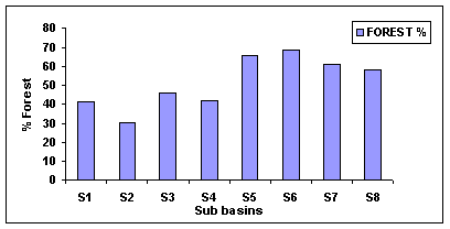
NandiholéThe total area of Nandiholé sub basin is 143.6 km2 in which 38.12 % area is covered by moist deciduous forest, followed by 30.56 % as grassland and scrub cultivable waste land. The habitation, road, rocky area and constructions occupied 11.14 %. Agricultural land and plantations occupied 11.33% and 5.52 % respectively. The amount of evergreen and semi-evergreen forest in Nandiholé catchment area ranks only 3.31 %. Finally the water bodies occupied 0.01% of the total area. This results show that the majority of catchment area occupied by disturbed forests and agricultural lands.
In Haridravathi sub basin of the total area of 278.9 km2 , 31.91 % is occupied by grassland, scrub and cultivable wasteland. Nearly 18.19 % of Haridravathi sub basin is used as agricultural land and 5.58 % for acacia and areca plantations. The evergreen and semi evergreen forests range about 2.28 % and deciduous forests ranges as 28.17 %. Habitation, road network and rocky area occupied 13.86 % of the total sub basin. The water bodies occupy 0.02 % of the total area of the sub basin.
MavinaholéThe third sub basin from the eastern side of the reservoir is Mavinaholé, its total area ranges 95.1 km2 . The maximum area of this sub basin covered by moist and deciduous forests about 41.62 %, followed by 24.68 % as grassland, scrub and cultivable wasteland. Habitation, road network, rocky area and constructions consume 11.6 % in total area. The agricultural and plantation activities occupied 9.81 % and 7.88 % respectively. The area occupied by water bodies in Mavinaholé sub basin is 0.03 %. The evergreen and semi evergreen forest ranges about 4.37 % in total area.
SharavathiSharavathi is the second largest sub basin in upstream with total area of 119.4 km2 , in which grassland, scrub and cultivable wasteland occupy 20 % of the land. 22.95 % of the total area occupied by deciduous and moist deciduous forests. Habitation and road network occupied 12.49 % that is 14.91 km 2 . 19.16 % of the total area consists of evergreen and semi evergreen forests. Agricultural land and plantations occupied 10.33 % and 14.66 %.
HilkunjiThe total area of Hilkunji sub basin is 85.1 km2 , in which 43.27 % of the land covered by the evergreen and semi evergreen forests. The deciduous and moist deciduous forest cover occupies 22.46 % in total area. Habitation, road network, rocky area and constructions make up 5.57 % of total area. Grassland and cultivable wasteland occupies 12.96 % of total cover.11. 5 % and 4.18 % of the total area of Hilkunji is used for plantation and agricultural activities.
Hurliholé
Habitation, road network, rocky area, construction, etc cover an area of 7.56 % of the 119 sq. Km of Hurliholé. 18.18% is covered by grassland, scrub, cultivable wastelands, etc. The semi-evergreen and evergreen forests make up 32.78% of the total area. Moist deciduous forests make up 27.91% whereas 10.74% of the total land area is planted with acacia and areca. The water bodies make up 0.88 % and the agricultural land covers about 1.97%.
YenneholéYenneholé sub-basin covers an area of 68.6 sq. km. 10.1% of that area is covered by habitation, road, rocky area and construction. The grassland, scrub and cultivable wastelands make up 14.86% while semi-evergreen and evergreen forests make up 37.89%. Moist deciduous forests cover 19.76% of the area and acacia and areca plantation cover 15.8%. 0.14% of the total area of 68.6 km2 is covered by water-bodies.
NagodiholéNagodiholé is the one of the smallest sub basin in the up stream with total area of 68.6 km2 . 52.14 % of the total area is occupied under evergreen and semi evergreen forests followed by 16.58 % of deciduous and moist deciduous forests. The land occupied for agriculture and plantations are 1.08 % and13.66 % in total area. Habitation, roads, rocky area and constructions occupy 7.46 % of total area. The land with grassland, scrub and cultivable wastes are 9.07 % in total area. The water bodies in Nagodiholé sub basin are 0.01 % in total area of 68. 6 km2 .
Sub basin |
Class - 1 |
Class -2 |
Class- 3 |
Class- 4 |
Class- 5 |
Class- 6 |
Class- 7 |
Total |
Nandiholé |
15.99 |
43.88 |
4.75 |
54.74 |
7.92 |
0.014 |
16.26 |
143.6 |
Haridravathi |
38.65 |
88.99 |
6.35 |
78.56 |
15.56 |
0.055 |
50.73 |
278.92 |
Mavinaholé |
11.03 |
23.47 |
4.15 |
39.58 |
7.49 |
0.028 |
9.32 |
95.09 |
Sharavathi |
14.91 |
24.36 |
22.87 |
27.40 |
17.50 |
0 |
12.33 |
119.4 |
Hilkunji |
4.74 |
11.02 |
36.82 |
19.11 |
9.83 |
0 |
3.55718 |
85.1 |
Nagodiholé |
5.11 |
6.22 |
35.76 |
11.37 |
9.37 |
0.006 |
0.74 |
68.6 |
Hurliholé |
8.99 |
21.63 |
39 |
33.21 |
12.7 |
1.04 |
2.34 |
119.02 |
Yenneholé |
6.92 |
10.19 |
25.99 |
13.55 |
10.83 |
0.096 |
0.93 |
68.54 |
Note: Class-1: Habitation, road, rocky area, and constructions. Class-2: Grassland, scrub, cultivable wasteland. Class-3: Evergreen to semi evergreen forests. Class-4: Moist deciduous forests. Class-5: Plantations. Class-6: Water bodies. Class-7: Agricultural land. |
||||||||
Sub basin |
Class 1 |
Class -2 |
Class- 3 |
Class- 4 |
Class- 5 |
Class- 6 |
Class- 7 |
Nandiholé |
11.4 |
30.56 |
3.31 |
38.12 |
5.52 |
0.01 |
11.33 |
Haridravathi |
13.86 |
31.91 |
2.28 |
28.17 |
5.58 |
0.02 |
18.19 |
Mavinaholé |
11.6 |
24.68 |
4.37 |
41.62 |
7.88 |
0.03 |
9.81 |
Sharavathi |
12.49 |
20.41 |
19.16 |
22.95 |
14.66 |
0 |
10.33 |
Hilkunji |
5.57 |
12.96 |
43.27 |
22.46 |
11.56 |
0 |
4.18 |
Nagodiholé |
7.46 |
9.07 |
52.14 |
16.58 |
13.66 |
0.01 |
1.08 |
Hurliholé |
7.56 |
18.18 |
32.78 |
27.91 |
10.74 |
0.88 |
1.97 |
Yenneholé |
10.1 |
14.86 |
37.89 |
19.76 |
15.8 |
0.14 |
1.37 |
Note: Class-1: Habitation, road, rocky area, and constructions. Class-2: Grassland, scrub, cultivable wasteland. Class-3: Evergreen to semi evergreen forests. Class-4: Moist deciduous forests. Class-5: Plantations. Class-6: Water bodies. Class-7: Agricultural land. |
|||||||
WATER QUALITY
The eight main tributaries of River Sharavathi were selected around the catchment area on the basis of their location and the streams feeding the Linganamakki reservoir. The tributaries feeding the reservoir on the eastern side include Nandhiholé, Haridravathi and Mavinaholé. These tributaries can be grouped under the same category, as they confluence at reservoir from eastern part. The tributaries feeding on the southern side include Sharavathi and Hilkunji. The western tributaries are Nagodiholé, Hurliholé and Yenneholé. The major differences between these three groups are land use pattern and topography, the parameters that determine hydrological activities. The results of physico chemical parameters of the tributaries are shown in Figures 7-11 and Table 6.
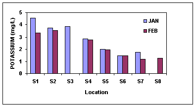
The Nandiholé tributary water quality was analysed during January and February. The results show that the pH was slightly alkaline during February with a pH value of 7.95. Similarly total dissolved solids (69.22 mg/l), electrical conductivity (138.3 µS), turbidity (25-50 NTU), alkalinity (64 mg/l), sodium (22.79mg/l) were high during the month of February compared to that of January. This is mainly due to the low stream discharge and subsequent concentration of the ions. Algal pollution index shows the probable evidence of organic pollution with the score of 14 and 15.
Haridravathi, one of the major tributary of River Sharavathi from the eastern side and its water quality results are listed in Table 6. The pH value was slightly alkaline (7.54-7.98) for the both the sampling period. The increase in the dissolved ions is shown by the high TDS (65.94-76.02 ppm), electrical conductivity (130.8-152µS), sodium (23.18-23.57), potassium (3.5-3.7), and turbidity values (25-50 NTU). Palmer's index gives the score of 2 and 11; it shows very less amount of organic pollution. The coliform test shows positive results through out the sampling period.
In Mavinaholé the pH ranges between 6.2-7.24, it shows the hydrogen ion concentration is near neutral condition. The TDS varies from 39.13- 58.51 ppm through out the study period; the increase in the dissolved ions concentration is also shown by electrical conductivity value (78-116.7µS) and sodium and potassium values 15-18 mg/L and 4.15-6.03 mg/L. The Palmer's pollution index (2 and 9) shows no evidence for the organic pollution.
The pH of the tributary Sharavathi varied slightly (6.6 7.13) through out the sampling period. And the conductivity was found in the range of 75.72-116 µScm-1 . The reason for this variation may be dissociation of minerals from soil or other human activities in tributary like washing and bathing. The total hardness and alkalinity were found in the range of 20-25 and 28mg/l, respectively. The concentration range of both the parameters were found within the soft water limits. Turbidity value ranges between 10-25 NTU. The sodium and potassium values are 12.7-13.29 and 2.77-2.87 mg/l respectively. The coliform test showed positive results through out the sampling period. The Palmer's algal pollution index shows the value of 8 and 7, indicating that organic pollution is not high.
The pH range of Hilkunji was near neutral condition (6.44-6.98). The amount of the dissolved ions are very less in this station, it is clearly shown by low TDS (21.52-25.54 ppm), electrical conductivity (43.07-50.84µS). Algal index value for this station is recorded as nil and 8; it shows the absence of any pollution indicator species for first collection and very less score in second collection. The western tributary Nagodiholé showed near neutral pH values (6.45 7.52), high turbidity values during the month of February (25-50 NTU), low values of alkalinity (12mg/l), acidity (5 mg/l), chlorides (4.9 and 5.9 mg/l), hardness (20 and 25 mg/l), calcium, magnesium, sodium, potassium etc. All these values were within permissible limits for inland water quality. The Palmer's algal index shows nil and very low amount of organic pollution with the scores of 0 and 8 respectively.
The pH range of Hurliholé shows the neutral status of hydrogen ion concentration (6.6-7.0). The total dissolved solids ranges from 21.19-27.41 ppm. The electrical conductivity values are in the range 42.46-54.44 µS. The alkalinity and acidity ranges 16-20 and 4-5 respectively. The coliform test shows positive results through out the sampling period indicating the faecal contamination. The algal pollution status determines no evidence of organic pollution.
The pH range of Yenneholé ranges with in the neutral condition 6.3-6.8. The total dissolved solids are in the range of 16-29.34ppm. The chloride content ranges from 3.9-7.4 mg/L. The sodium and potassium values range from 3.9-6.0mg/L and1.2 mg/L respectively. Algal index shows the value of 0 and 4, which indicates the very less organic pollutant content in the water.
Figure 7: Variations of pH between the Sub basins
S1 |
S2 |
S3 |
S4 |
S5 |
S6 |
S7 |
S8 |
|||||||||
JAN |
FEB |
JAN |
FEB |
JAN |
FEB |
JAN |
FEB |
JAN |
FEB |
JAN |
FEB |
JAN |
FEB |
JAN |
FEB |
|
| W T-C° | 29 |
30 |
28 |
30 |
28 |
29 |
30 |
34 |
29 |
33 |
n/a |
33 |
28 |
33 |
29 |
33 |
| pH | 6.88 |
7.95 |
7.54 |
7.98 |
6.92 |
7.24 |
6.6 |
7.13 |
6.44 |
6.98 |
n/a |
6.63 |
6.688 |
7.09 |
6.45 |
7.52 |
| TDS-ppm | 60.44 |
69.22 |
76.02 |
65.94 |
50.7 |
58.51 |
58.06 |
37.86 |
21.52 |
25.54 |
n/a |
20.88 |
21.19 |
27.41 |
20.02 |
23.8 |
| EC-µs/cm | 121 |
138.3 |
152 |
130.8 |
100.3 |
116.7 |
116 |
75.72 |
43.07 |
50.84 |
n/a |
41.55 |
42.46 |
54.44 |
40.13 |
47.38 |
| Tur-NTU | 25-50 |
25-50 |
25-50 |
25-50 |
25-50 |
25-50 |
10-25 |
10-25 |
10-25 |
25-50 |
n/a |
10-25 |
10-25 |
10-25 |
10-25 |
25-50 |
| Alk-mg/L | 52 |
64 |
76 |
60 |
20 |
48 |
28 |
28 |
20 |
16 |
n/a |
12 |
16 |
20 |
12 |
12 |
| Aci-mg/L | 15 |
16 |
25 |
12 |
15 |
20 |
5 |
16 |
10 |
8 |
n/a |
4 |
5 |
4 |
5 |
4 |
| Chl-mg/L | 12.49 |
5.9 |
9.99 |
7.9 |
4.99 |
7.9 |
7.49 |
3.9 |
4.99 |
3.9 |
n/a |
5.9 |
7.49 |
5.9 |
4.99 |
5.9 |
| Har-mg/L | 35 |
40 |
75 |
50 |
45 |
50 |
20 |
25 |
15 |
20 |
n/a |
10 |
20 |
20 |
25 |
20 |
| Cal-mg/L | 20 |
25 |
50 |
30 |
25 |
15 |
10 |
5 |
10 |
10 |
n/a |
5 |
10 |
5 |
5 |
10 |
| Mag-mg/L | 15 |
15 |
25 |
20 |
20 |
35 |
10 |
20 |
5 |
10 |
n/a |
5 |
10 |
15 |
20 |
10 |
| Sul-mg/L | 3.827 |
3.04 |
6.49 |
6.666 |
4.028 |
3.742 |
3.019 |
2.572 |
3.269 |
2.806 |
n/a |
2.339 |
2.908 |
2.105 |
2.361 |
2.105 |
| Pho-mg/L | 0.02 |
0.02 |
0.006 |
0.015 |
0.002 |
0.0041 |
0.023 |
0.013 |
0.007 |
0.006 |
n/a |
0.008 |
0.006 |
0.0061 |
0.0102 |
0.0105 |
| Nit-mg/L | 0.59 |
0.53 |
0.5 |
0.52 |
0.49 |
0.47 |
0.52 |
0.55 |
0.48 |
0.48 |
n/a |
0.48 |
0.49 |
0.54 |
0.46 |
0.48 |
| Sod-mg/L | 25.026 |
22.79 |
23.57 |
23.18 |
14.84 |
18.43 |
12.7 |
13.29 |
9 |
7.76 |
n/a |
3.97 |
7.85 |
5.43 |
5.23 |
4.36 |
| Pot-mg/L | 4.55 |
3.36 |
3.762 |
3.56 |
3.86 |
6.03 |
2.87 |
2.77 |
2 |
1.98 |
n/a |
1.28 |
1.78 |
1.18 |
1.48 |
1.48 |
| Coliform | P |
P |
P |
P |
P |
P |
P |
P |
P |
P |
n/a |
N |
N |
P |
P |
N |
| S1 = Nandhiholé, S2 = Haridravathi, S3 = Mavinaholé, S4 = Sharavathi, S5 = Hilkunji, S6 = Yenneholé, S7 = Hurliholé, S8 = Nagodiholé. | ||||||||||||||||
| WT; Water Temperature, TDS; Total Dissolved Solids, EC; Electrical Conductivity, Tur; Turbidity, Alk; Alkalinity, Aci; Acidity, Chl; Chlorides, Har; Hardness, Cal; Calcium, Mag; Magnesium, Sul; Sulphates, Pho; Phosphates, Nit; Nitrates, Sod; Sodium, Pot; Potassium, Coliform = P; Positive & N; Negative | ||||||||||||||||
Figure 8: Variations of Conductivity between the Tributaries
Figure 9: Variations of TDS between the Tributaries
Figure 10: Variation of Sodium between the Tributaries
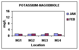
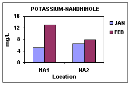
Figure 11: Variation of Potassium between the Tributaries
Figure 12: Percentage Forest in the catchment of the Tributaries
STREAM FLOW
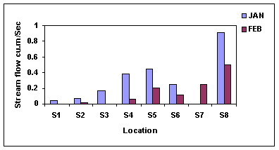
The stream flow analyses show a wide variation between the tributaries of eastern and western side of the reservoir. In Nandiholé stream flow was 0.04 and 0.0018m3 /second for the month of January and February. It shows drastic change between the first and second collection. In Haridravathi first month stream flow was 0.07 m3/second and followed by 0.01 m3 /second. Mavinaholé, the third tributary from eastern side showed 0.17 m3 /second during the first observation and flow was stopped during the second collection. 0.38 m3 /second and 0.06 m3 /second were the flow rate observed in Sharavathi. It is one of the perennial water sources in the study area, but the varied stream flow between months shows the anthropogenic pressure (creating bunds for agriculture) on the aquatic ecosystem. In Hilkunji the first observation shows the discharge of 0.45 m3 /second and in second observation it reduced half in to 0.24 m3 /second. Incase of the Hurliholé the discharge measured for the first observation is 0.24 m3 /second and followed by 0.11 m3/second in second month. Due to inaccessibility only February month discharge is available for Yenneholé, during this time it shows a discharge rate of 0.24 m3 /second. The highest stream flow observed across the upstream was at Nagodiholé. During the first collection it shows 0.92 m3 /second and on the second observation it was 0.5 m3 /second.
Figure 13: Variation of Stream flow between the Tributaries
RAINFALL
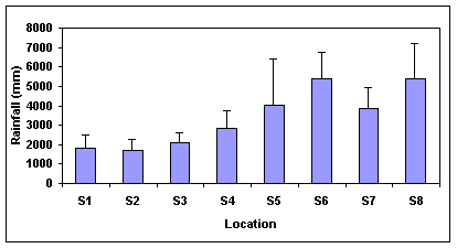
The average rainfall variation between the sub basins was computed by last 20 years rainfall data. The annual rainfall in Nandhiholé (S1) and Haridravathi (S2) sub basins ranges between 1500 2000 mm. In Mavinholé (S3) the annual rainfall ranges between 2500 3000mm. Sharavathi (S4) sub basin receives rainfall of 3000-4000 mm per annum. Hilkhunji (S5) sub basin receives annual rainfall of 4000-5000 mm. The annual rainfall in Yenneholé (S6) sub basin ranges about 5000-7000mm. Hurliholé (S7) sub basin receives 4000-5000 mm of rainfall per year. Nagodiholé receives 5000-6000 mm of rainfall annually. It shows that the eastern side sub basins receive least rainfall while comparing with the western side sub basins of Sharavathi river basin. The variation of rainfall across the sub basins is shown in Figure 14.
MICRO SCALE ASSESSMENT
Vegetation Analysis
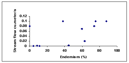
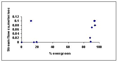
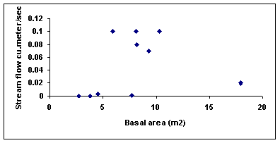
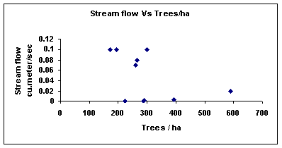
The vegetation analysis in the catchment area of the streams of Nandiholé, Nagodiholé and Yenneholé reveal inter relationships among various components of the ecosystem. The catchment area of the streams of Nandiholé sub basin shows the very low Western Ghats endemism (4.35%, 8.62%, 11.71%, and 38 %) and evergreenness (0%, 11.76%, 18.97%, and 15.56 %) and it indirectly shows that the disturbance in the forest of catchment area. The vegetation analysis in Nagodiholé sub basin stream catchment shows the endemism values of 59.62%, 73.58% and 87.5 % and evergreeness values in the range of 90.38%-94.34 %. The endemism of trees in the catchment area of Yenneholé sub basin was 44.44%, 62.71% and 75.36 % and the percentage evergreeness is 88.14%, 88.89% and 94.2 %. The total basal area for each quadrate was calculated and it was seen that wherever the basal area was high, the stream flow was also high as shown in the Figure 20. The endemism and evergreenness was positively co-related with stream flow as shown in the Figures 18 and 19. The sub-basin with higher endemism, evergreenness and the total basal area has streams with higher stream discharge. Catchment of Nagodiholé and Yenneholé streams showed higher endemism, evergreeness and total basal area and thus in the stream discharge, whereas in Nandiholé stream discharge decreased and so did the endemism, evergreenness and total basal area of trees. This corroborates that the status of catchment vegetation is correlated to the water discharge, which is shown in figure 15 - 17.
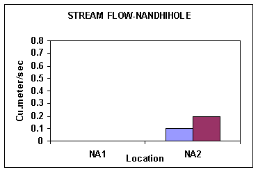
The stream flow measurement varied radically between the first and second order streams of the three sub basins as shown in the Figures 15 - 17 . In Nandiholé sub basin, during the study period, the streams Byadarakoppa (NA3) and Hosur (NA4) dried up during January and February. In the first month stream discharge observation Hebbailu shows 0.0011 m3 /second and consecutive month as 0.0002 m3 /second. Hunsevalli stream in this sub basin shows 0.1 m3 /second for the month of January and 0.26 m3 /second during second observation. In this stream the discharge rate was increased during the second month, because people opened the bunds after the irrigation. It shows the anthropogenic activities in the stream by the human activities.
In Nagodiholé sub basin, Alagodu stream shows 0.24 m3 /second and 0.19 m3 /second stream discharges during the study period. In Gurta stream the first month stream discharge was 0.1 m3 /second and during the second observation it was 0.7 m3 /second. In Chengavalli stream the stream discharge for January and February was 0.08 and 0.04 m3 /second respectively. The fourth stream selected in Nagodiholé sub basin was Kodachadri in this stream January month discharge was 0.1 m3 /second and in February it showed 0.065 m3 /second.
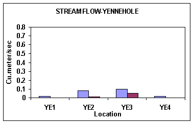
The streams selected in Yenneholé sub basin are Keshvapura, Chengodu, Beligar and Karini. Keshvapura stream showed the discharge of 0.03 and 0.02 m3 /second for the month of January and February. In Chengodu January month stream discharge was 0.08 m3 /second and in February it was recorded as 0.01 m3 /second. In the first month stream discharge observation in Beligar shows 0.1 m3 /second and consecutive month as 0.05 m3 /second. Karini stream in this sub basin shows 0.02 m3 /second for the month of January and 0.0039 m3 /second during second observation.
Figure 15: Variation of Stream flow in Nandhiholé sub basin
Figure 16: Variation of Stream flow in Nagodiholé sub basin.
Figure 17: Variation of Stream flow in Yenneholé sub basin
Figure 18: Correlation between Endemism and Stream flow
Figure 19: Correlation between Evergreeness and Stream flow
Figure 20: Correlation between Basal Area and Stream flow
Figure 21: Correlation between Trees/ha and Stream flow
Water quality analysisThe sub-basin wise physico-chemical and biological analysis of the water samples is presented in Tables 7-9. The streams in the sub-basins were selected based on their topography, land-use pattern and rainfall. The month-wise variations in the physico-chemical parameters across the three sub-basins are given in Figures 25 33.
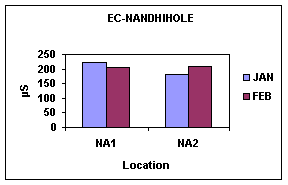
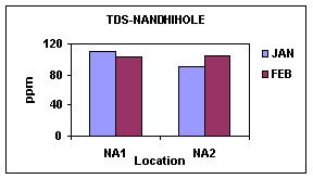
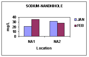
NandiholéThe pH of the water was slightly alkaline with values ranging from 6.7 to 7.65, which was also reflected in increased alkalinity (46 100 mg/l). The total dissolved solids during all the months in all the streams in Nandiholé sub-basin were high (TDS 53.37 110.6 mg/l). This was shown by high Electrical conductivity (106.1 221.4µS) and turbidity (> 25 - >100 NTU), which exceeded the Indian standard values for inland waters. These high values are mainly due to the increased agricultural run-off from the catchment area. The vegetation studies in the catchment area show a very less percentage of endemism and evergreeness, which shows the quality of forest situated in the catchment area. The sub-basin is characterized by low altitude and low rainfall with an average of 1800 mm. Consequently, the forest area in the sub-basin is only 41% and the rest of the area is cultivated. Hence, the anthropogenic activities in the catchment area of the streams in the sub-basin contribute to the pollution load in the water. The coliform test was positive for all the streams during all the months in the sub-basin indicating faecal contamination. Palmer's algal pollution index shows the probable evidence for organic pollution in both the locations; the score range from 6-17.
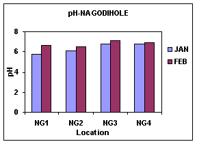
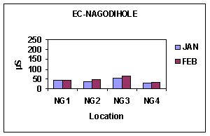
Nagodiholé
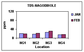
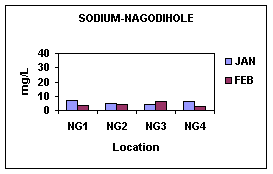
In Nagodiholé sub-basin the streams Alagodu (NG1), Garta (NG2), Chengavalli (NG3) and Kodachadri (NG4) are selected for study. The pH in all the streams was slightly acidic to neutral (5.73 7.09). The stream flow was present throughout the sampling period. The total dissolved solids (15.24 32.41 mg/l), electrical conductivity (30.47 64.75µS), turbidity (10-25 NTU) were within the standard values for inland waters. The other parameters like nitrates (0.219 0.5 mg/l), phosphates (0.005-0.028 mg/l), sulphates (1.754 3.4 mg/l), sodium (2.71- 6.768mg/l), potassium (0.891-2.69 mg/l), nitrates (0.214 0.51 mg/l), etc were within the permissible limits. The faecal coliform test was negative for most of the streams. Algal pollution status confirms that there is no evidence for the organic pollution. The results of this sub-basin reveal that there is no inflow of contaminants to the streams and there is no anthropogenic influence in the sub-basin.
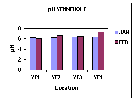
Yenneholé
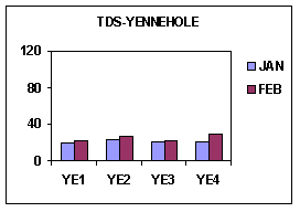
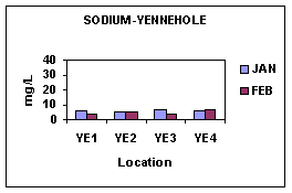
The Yenneholé sub-basin included the streams of Karini (YE1), Chengode (YE2), Beligar (YE3) and Keshavapura (YE4). The pH was nearly neutral with values ranging from 6 7.26. The total dissolved solids (20.15 29.1mg/l), conductivity (40.1-58.3µS), turbidity (10-25 NTU), alkalinity (8-16mg/l), acidity (4-10mg/l), chlorides (3.9 9.9 mg/l), phosphates (0.004-0.008mg/l), etc were within the standard limits for inland water samples. The stream flow was present throughout the sampling period. Palmer's algal pollution index confirms that there is no evidence for the organic pollution with the scores of 2-7. The results show that there is no pollution load in the streams in the Yenneholé sub-basin. The Figures 21 29 represent the results of physico-chemical analysis of the three sub-basins.
Figure 22 |
Figure 23 |
Figure 24 |
Figure 25 |
Figure 26 |
Figure 27 |
HEBBAILU (NA1) |
HUNSEVALLI (NA2) |
|||
JAN |
FEB |
JAN |
FEB |
|
Temperature- °C |
31 |
31 |
32 |
29 |
PH |
6.78 |
6.828 |
7.64 |
7.27 |
TDS-ppm |
110.6 |
103.7 |
91.07 |
104 |
EC-µs |
221.4 |
207 |
181.8 |
207.8 |
Turbidity-NTU |
25-50 |
25-50 |
25-50 |
25-50 |
Alkalinity-mg/l |
46 |
88 |
92 |
100 |
Acidity-mg/l |
15 |
28 |
10 |
24 |
Chlorides-mg/l |
9.9 |
9.9 |
12.4 |
13.9 |
Hardness-mg/l |
40 |
15 |
75 |
100 |
Calcium-mg/l |
25 |
15 |
45 |
55 |
Magnesium-mg/l |
15 |
0 |
30 |
45 |
Sulphates-mg/l |
3.482 |
3.625 |
4.002 |
3.508 |
Phosphates-mg/l |
0.01 |
0.016 |
0.006 |
0.0192 |
Nitrates-mg/l |
0.56 |
0.59 |
0.436 |
0.52 |
Sodium-mg/l |
21.24 |
35.01 |
31.71 |
27.83 |
Potassium-mg/l |
5.24 |
13.06 |
6.63 |
7.82 |
Coliform |
Positive |
Positive |
Negative |
Positive |
KARINI (YE1) |
CHENGODE (YE2) |
BELIGAR (YE3) |
KESHVAPURA (YE4) |
|||||
JAN |
FEB |
JAN |
FEB |
JAN |
FEB |
JAN |
FEB |
|
| Temperature- °C | 25 |
27 |
25 |
24 |
28 |
32 |
26 |
28 |
| PH | 6.23 |
6 |
6.2 |
6.63 |
6.29 |
6.44 |
6.3 |
7.26 |
| TDS-ppm | 20.15 |
22.66 |
22.85 |
27.93 |
21.48 |
22.01 |
21.36 |
29.1 |
| EC-µs | 40.1 |
45.17 |
42.49 |
55.28 |
42.9 |
44 |
42.52 |
58.3 |
| Turbidity-NTU | 10-25 |
10-25 |
10-25 |
10-25 |
10-25 |
10-25 |
10-25 |
10-25 |
| Alkalinity-mg/l | 16 |
16 |
12 |
12 |
8 |
12 |
16 |
16 |
| Acidity-mg/l | 5 |
8 |
5 |
5 |
10 |
4 |
5 |
8 |
| Chlorides-mg/l | 4.99 |
3.9 |
7.49 |
7.49 |
7.49 |
5.9 |
4.99 |
9.9 |
| Hardness-mg/l | 15 |
30 |
20 |
20 |
20 |
20 |
10 |
30 |
| Calcium-mg/l | 10 |
5 |
10 |
10 |
10 |
10 |
5 |
15 |
| Magnesium-mg/l | 5 |
25 |
10 |
10 |
10 |
10 |
5 |
15 |
| Sulphates-mg/l | 1.684 |
1.52 |
2.257 |
2.339 |
1.684 |
1.52 |
2.069 |
2.572 |
| Phosphates-mg/l | 0.004 |
0.006 |
0.007 |
0.0073 |
0.008 |
0.0073 |
0.0072 |
0.00761 |
| Nitrates-mg/l | 0.42 |
0.47 |
0.49 |
0.56 |
0.41 |
0.45 |
0.41 |
0.48 |
| Sodium-mg/l | 5.82 |
4.07 |
5.43 |
5.33 |
6.98 |
3.97 |
6.01 |
6.59 |
| Potassium-mg/l | 0.79 |
0.69 |
1.72 |
2.97 |
2.178 |
0.89 |
1.68 |
2.67 |
| Coliform | Negative |
Positive |
Negative |
Positive |
Positive |
Positive |
Positive |
Positive |
ALAGODU (NG1) |
GARTA |
(NG2) | CHENGAVALLI (NG3) |
KODACHADRI (NG4) |
||||
JAN |
FEB |
JAN |
FEB |
JAN |
FEB |
JAN |
FEB |
|
| Temperature- °Cs | 28 |
28 |
29 |
27 |
28 |
27 |
28 |
28 |
| PH | 5.73 |
6.63 |
6.07 |
6.51 |
6.77 |
7.09 |
6.75 |
6.93 |
| TDS-ppm | 20.67 |
20.16 |
18.58 |
22.3 |
26.56 |
32.41 |
15.24 |
17.37 |
| EC-µs | 41.41 |
40.27 |
37.26 |
44.63 |
53.38 |
64.75 |
30.47 |
34.72 |
| Turbidity-NTU | 10-25 |
10-25 |
10-25 |
10-25 |
10-25 |
10-25 |
10-25 |
10-25 |
| Alkalinity-mg/l | 8 |
12 |
12 |
12 |
24 |
20 |
8 |
8 |
| Acidity-mg/l | 5 |
4 |
5 |
4 |
5 |
4 |
5 |
4 |
| Chlorides-mg/l | 9.9 |
5.9 |
4.99 |
3.9 |
4.99 |
5.9 |
4.99 |
3.9 |
| Hardness-mg/l | 15 |
20 |
15 |
15 |
20 |
10 |
15 |
20 |
| Calcium-mg/l | 5 |
5 |
5 |
10 |
15 |
5 |
5 |
5 |
| Magnesium-mg/l | 10 |
15 |
10 |
5 |
5 |
5 |
10 |
15 |
| Sulphates-mg/l | 2.648 |
1.871 |
2.015 |
1.754 |
2.358 |
2.455 |
2.056 |
1.754 |
| Phosphates-mg/l | 0.0059 |
0.008 |
0.01 |
0.028 |
0.008 |
0.008 |
0.0049 |
0.0138 |
| Nitrates-mg/l | 0.46 |
0.51 |
0.42 |
0.5 |
0.48 |
0.57 |
0.39 |
0.49 |
| Sodium-mg/l | 6.98 |
3.2 |
4.94 |
4.07 |
4.17 |
6.01 |
6.59 |
2.71 |
| Potassium-mg/l | 1.485 |
1.18 |
1.28 |
1.38 |
0.891 |
1.58 |
1.683 |
1.08 |
| Coliform | Negative |
Positive |
Positive |
Positive |
Negative |
Positive |
Negative |
Positive |
Figure 28 |
Figure 29 |
Figure 30 |
Figure 31 |
Figure 32 |
Figure 33 |
Figure 34 |
Figure 35 |
Figure 36
Soil Analysis
Soil samples representative of the Nandiholé sub-basin was collected from catchment area of Byadarakoppa, Hunsevalli, Hosur, Hebbailu and Jamburmane and they were subjected to physico-chemical analysis. The soil pH was acidic to moderately acidic (pH - 4.831 6.777), which may be due to the agricultural activities in the catchment area. The bulk densities of the soil in the sub-basin were high ranging from 1.197 g/cc 1.758 g/cc. In these areas the water holding capacity was quite low with values ranging from 9.367 31.93 %. The percentage of organic matter in all the sampled areas was less (Organic matter 0.23 4.03%). The relative concentration of the other elements were Potassium > Phosphates > Calcium > Magnesium > Sodium. The low concentrations of these ions show the degraded quality of the soil due to various anthropogenic activities, mainly agriculture in the catchment area. The variations in the physico-chemical parameters are presented in Table 10.
The representative soil samples collected from the Nagodiholé sub-basin subjected to physico-chemical analysis revealed that the soil is slightly acidic with pH values of 5.26 6.32 and high organic content. Such soils are optimal for plant growth and microbial activity. The soils of Nagodiholé sub-basin had high moisture content (9.3 21.23 %) and high water holding capacity ranging from 19.92 % to 44.135%. The concentration of other elements like calcium, magnesium, potassium, sodium, etc revealed that the soil was fertile.
The soil samples collected in the sub-basin show high moisture content (14.3-16.3%), high water holding capacity (32.804 38 %) and high organic matter (1.27 5.88%). The soils were rich in potassium (42 kg/ha 100 kg/ha) and phosphates (0.64 kg/ha 1.9 kg/ha), revealing a highly productive soil.
The difference among the sub-basins in the soil and water quality can be attributed to the land-use pattern in the catchment area, rainfall pattern and topography. The streams of the Nandiholé sub-basin was organically polluted as seen by high values of pH, alkalinity, electrical conductivity, total dissolved solids, sodium, potassium, palmer's index, coliform bacteria, etc whereas the streams in the Yenneholé and Nagodiholé sub-basin were relatively less polluted. This is mainly due to agricultural activities and the resultant run-off in the Nandiholé sub-basin. The catchment area of Nagodiholé and Yenneholé were characterized by the presence of evergreen, semi-evergreen and moist deciduous forests. The soil quality analysis revealed that the soil was productive in the Nagodiholé and Yenneholé sub-basins whereas the low concentration of essential ions in the Nandiholé sub-basin showed degraded soils.
Location |
Bulk Density g/cc |
Moisture content % |
WHC |
pH |
EC µS |
Organic matter % |
Calcium mill.equ |
Magnesium milli.equ |
Sodium milli.equ |
Potassium mg/ G |
Phosphorous mg/G |
NA1 |
1.3823 |
12.4 |
9.367 |
6.296 |
35.45 |
4.03 |
0.45 |
0.3 |
0.00275 |
14.20288 |
1.64 |
NA2 |
1.0965 |
9.7 |
12.964 |
5.987 |
30.7 |
4.67 |
0.4 |
0.4 |
0.002 |
5.3504 |
1.53 |
NA3 |
1.197 |
15.4 |
13.68 |
6.065 |
61.06 |
3.29 |
0.45 |
0.2 |
0.00175 |
19.35872 |
0.6 |
NA4 |
1.3073 |
17.7 |
12.63 |
6.374 |
53.97 |
3.89 |
0.3 |
0.2 |
0.002 |
30.93504 |
0.8 |
NA5 |
1.658705 |
11.48515 |
13.2 |
4.831 |
24.72 |
0.67 |
0.1 |
0.05 |
0.00275 |
5.44768 |
3.4 |
NA6 |
1.360138 |
21.6 |
31.93613 |
6.777 |
31.01 |
1.27 |
0.25 |
0.2 |
0.00475 |
9.33888 |
0.96 |
NA7 |
1.227442 |
19.15323 |
29.31727 |
5.839 |
77.73 |
0.53 |
0.1 |
0.15 |
0.002 |
2.9184 |
0.831 |
NA8 |
1.758227 |
17.52988 |
13.77246 |
6.274 |
56.5 |
0.23 |
0.15 |
0 |
0.003 |
2.72384 |
0.4 |
NG1 |
1.5587 |
9.3 |
35.956 |
6.322 |
55.06 |
4.13 |
0.8 |
0.25 |
0.00275 |
19.456 |
0.92 |
NG10 |
1.094745 |
21.23016 |
41.8 |
6.305 |
14.55 |
3.96 |
0.9 |
0.2 |
0.003 |
24.70912 |
0.35 |
NG2 |
1.133 |
10.5 |
30.953 |
5.487 |
21.03 |
2.55 |
0.2 |
0.1 |
0.00175 |
7.00416 |
0.76 |
NG3 |
1.15 |
11.7 |
38.604 |
5.606 |
34.3 |
2.45 |
0.4 |
0.1 |
0.00225 |
15.75936 |
0.29 |
NG4 |
1.592357 |
7.056452 |
28.88446 |
5.117 |
18.48 |
1.44 |
0.05 |
0.05 |
0.00325 |
4.76672 |
0.85 |
NG5 |
1.426486 |
15.55118 |
44.13519 |
5.846 |
33.01 |
3.59 |
0.35 |
0.15 |
0.0025 |
13.52192 |
0.8 |
NG6 |
1.592357 |
10.6 |
19.92032 |
5.51 |
22.2 |
2.75 |
0.25 |
0.15 |
0.00225 |
17.80224 |
0.25 |
NG7 |
1.29379 |
9.306931 |
43.71257 |
5.676 |
25.21 |
2.79 |
0.3 |
0.25 |
0.0025 |
13.42464 |
0.9 |
NG8 |
1.691879 |
4.970179 |
39.84064 |
5.26 |
24.21 |
1.51 |
0.1 |
0.2 |
0.00275 |
12.16 |
0.5 |
NG9 |
1.592357 |
20.6 |
31.26253 |
5.209 |
16.05 |
1.27 |
0.05 |
0.05 |
0.015 |
3.4048 |
0.7 |
YE1 |
1.1282 |
16.3 |
38 |
6.118 |
116 |
5.88 |
0.8 |
0.4 |
0.004 |
44.65152 |
0.201 |
YE2 |
1.0976 |
14.3 |
32.804 |
6.037 |
38.33 |
1.27 |
0.4 |
0.4 |
0.00225 |
18.9696 |
0.39 |
| NA1-NA8 = Samples from Nandhiholé sub basin, NG 1-10 = Samples from Nagodiholé sub basin, and YE-1 and 2 = Samples from Yenneholé sub basin. | |||||||||||