Back
3. STUDY AREA
Next
Back |
3. STUDY AREA |
Next
|
The Western Ghats or Sahyadris are the main hill range in peninsular India that run along the states of Maharastra, Goa, Karnataka, Kerala and Tamil Nadu starting from the river Tapti in the north to Kanyakumari in the south, extending over a length of 1300 km is one of the 18 biodiversity hot spots (Myers, 1990, Gadgil, 1996) of the world. Since the ghats extend parallel to the coast rising up to the elevation of 900 1500 m above sea level, it forms a barrier to the monsoon winds from the southwest. The western side of the Ghats gets an average annual rainfall of 2000 4000 mm while the rainfall in eastern range is between 400 800 mm. These hill ranges are the main watershed in peninsular India from most of the rivers originates and flow into either Arabian Sea or Bay of Bengal.
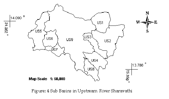
The Sharavathi River basin lies in the latitude 75° 17'38 to 75° 17'38 and longitude 14° 25'08 to 13° 42'36. Sharavathi takes its origin in Ambutirtha in Tirthahalli Taluk of Shimoga district and it is the one of the major West flowing river of Karnataka. The total length of the river is about 132 km and has a drainage area of 2771 sq km. It joins the Arabian Sea at Honnavar of Uttara Kannada district. The river drops to a vertical fall of about 253 m in Jog. The portion of the river above the Linkanamakki dam is upstream and the rest as downstream. The major tributaries in upstream (Linganamakki reservoir catchment) as shown in Figure 4, are Nandiholé, Haridravathi, Mavinaholé, Hilkunji, Yenneholé, Hurliholé, and Nagodiholé.
Figure: 3 Sharavathi River Basin.
US1: Nandhiholé US4: Sharavathi US7: Nagodiholé |
US2: Haridravathi US5: Yenneholé US8: Hilkunji US9 |
US3: Mavinholé US6: Hurliholé US9: Linganamakki |
Sharavathi River Basin has the monsoon period from May to October, followed by winter from November to January and summer from February to May. The average rainfall variation in the sub-basin ranges from 1200 mm to 5000 mm. Average minimum and maximum temperature is about 15-38oC. Southwest monsoon brings 5000-8000 mm of rainfall per annum in Sharavathi River Basin.
Soils in the region are mainly lateritic in origin and tend to be predominantly acidic and reddish to brownish in colour. The various type of soil existing in the study area is clay loamy, clayey, clayey-skeletal, and loamy.
The study area is mainly made up of metamorphic rocks, some regions in western parts made up of residual capping and volcanics or meta-volcanics. Various metamorphic processes on the pre existing rocks form metamorphic rocks. Residual capping is the insoluble products of rock weathering. The volcanics and meta-volcanics are igneous rock formed by the cooling and crystallization of lava erupted from the volcanoes.