Back
1. INTRODUCTION
Next
Back |
1. INTRODUCTION |
Next
|
In many countries, legislation mandates assessment of the water chemistry, biota, and physical environment of rivers, many of which have been highly impacted by human activities. For example, the objective of the Water (Prevention and Control of Pollution) Act, 1974 is the prevention of control of water pollution and the maintaining or restoring of wholesomeness of water, Clean Water Act of the United States is to restore and maintain the chemical, physical, and biological integrity of the nations' surface waters. Similarly, the Water Framework Directive of the European Union includes consideration of: (1) biological elements such aquatic flora, benthic invertebrates and fish; (2) hydro-morphological elements such as water flow, groundwater dynamics, river depth, width and continuity; and (3) chemical and physiochemical elements such as thermal and oxygenation conditions, salinity, acidification, nutrients, and specific pollutants (Stalzer and Bloch, 2000). Addressing such diverse components poses a serious challenge for monitoring riverine systems. Landscape ecology emphasizes the interaction between spatial pattern and ecological process (Turner, 1989; Turner et al., 2001) and has conceptual and technical tools relevant to the monitoring of rivers and their associated catchments. Simple landscape metrics describing the amount of human altered habitats can be useful indicators of water chemistry, biotic and hydrologic variables, which in turn save the aquatic ecosystem.
Aquatic ecosystem is one of the most productive ecosystems in the world. In spite of the enormous volume of the water in the planet, only a small portion of it is available for our use. 97 % of the total water is present in oceans and sea as saline water, which is not useful; while fresh water makes up only 2.6 % and 4 / 5 of that is immobilized as ice and thus equally useless. Fresh water aquatic ecosystems include streams, rivers, lakes, ponds, and ground water. The large proportion of the earth's biodiversity resides in aquatic environments (McAllister et al , 1997; Groombridge and Jenkins 1998). Numerous plants and animals, ranging from microscopic algae to large plant, from protozoans to mammals, a variety of morphological, anatomical, and physiological adaptations allow them to survive and grow in water (Gopal and Chauhan, 2001).
Aquatic ecosystem provide many critical services to humans, such as plants (both macrophytes and algae) carry out photosynthesis and produce the oxygen and bacteria process the organic waste products and maintain good water quality. Riparian vegetation mitigates floods and provides more stable river and spring flows, more reliable flow regimes can be utilised for food production, transport, water supply or to support terrestrial ecosystems and wildlife. Healthy ecosystems ensure maintenance of biodiversity and hence resilience to the pressures of utilization. Fresh water environments are divided in to two major categories, lotic ( lotus = washed or running water), and lentic ( lenis = calm or standing water) habitats based on the currents and ratio of the surface area. Lotic habitats are those existing in relatively fast running streams, springs, rivers and brooks. Lakes, ponds, swamps, etc represents the lentic habitats (Diwan and Arora, 1995). The holistic approaches in planning involving all components are required to ensure the sustainability. This requires timely and accurate data pertaining to the quality and quantity. This necessitates inventorying, and regular mapping and monitoring of the drainage basin.
Aquatic bodies can be fully assessed by three major components, hydrology, physico-chemical, and biology. A complete assessment of water quality is based on appropriate monitoring of these components.
Aquatic quality assessment is the overall process of evaluation of the physical, chemical and biological nature of the water in relation to natural quality, human effects and intended uses, particularly which may affect human health and health of the aquatic ecosystem. The main theme of the aquatic quality assessment is to:
• define the status of water quality,
• identify the trends in water quality,
• define the causes of observed condition and trends,
• identify the types of water quality problems that occur in specific geographical areas, and
• provide the accumulated information and assessments in a form that resource management and regulatory agencies can use to evaluate alternatives and make necessary decisions
All freshwater bodies are inter-connected, from the atmosphere to the sea, via the hydrological cycle. Thus water constitutes a continuum, with different stages ranging from rainwater to marine waters. The hydrodynamic characteristics of each type of water body are highly dependent on the size of the water body and on the climatic conditions in the drainage basin.
Hydrology: Water in the catchment, its occurrence, distribution and circulation, its physical and chemical properties, their effect on the environment and on life of all the forms is well understood through proper understanding of the hydrologic process in the catchment. The direction of movement of the water is fundamental property of lotic ecosystem. Dissipation of energy from moving masses of water affects the morphology of streams, sedimentation patterns, water chemistry, and biology of organisms inhabiting them. The continual down gradient movement of water, dissolved substances, and suspended particles in streams and rivers is derived primarily from the land area draining into a given stream channel. The hydrological, chemical, and biological characteristics of a stream or river reflect the climate, geology, and vegetation cover of the drainage basin (Hynes, 1970; Oglesby et al., 1972; Beaumont, 1975; Likens et al., 1977).
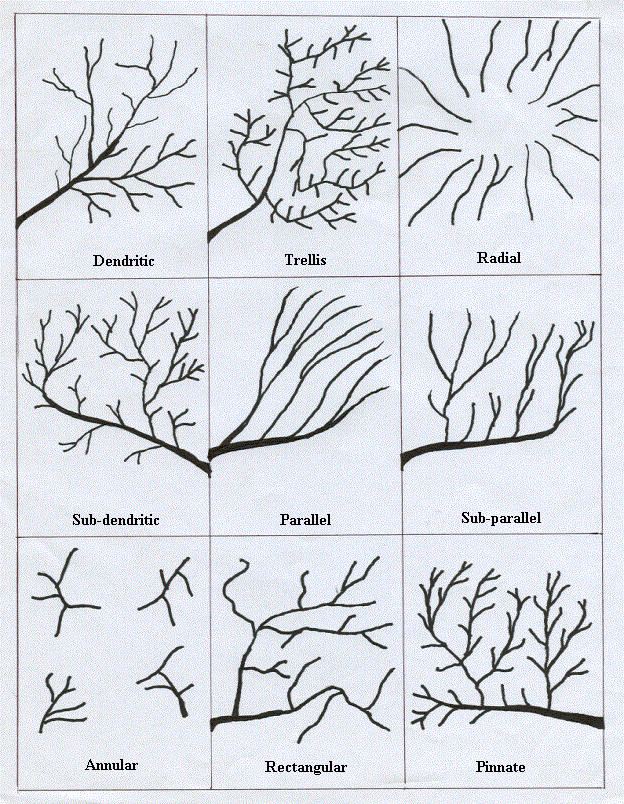
Drainage basin (drainage basin is equivalent term to watershed, catchment) is the area drained by tributary streams that coalesce into a main channel. The line, which divides the surface runoff between two adjacent river basins, is called the topographic water divide, or the watershed divide. The divide follows the ridgeline around the basin crossing the stream only at the outlet point. It marks the highest points between the basins, but isolated peaks within a basin may reach higher elevations than any point on the divide. The combined effects of climate and geology on the catchment topography yield an erosion pattern, which is characterized by a network of streams. Some of the frequently observed stream patterns are,
i. Dentric: When a region is homogenous offering no variation in the resistance to the flow of water, the resulting streams run in all directions without definite preference to any one particular region.
ii. Trellis: The trellis drainage pattern is develops when the underlying rock is strongly folded or sharply dipping. The longer streams will have preference to one particular orientation and the other tributaries will have an orientation and the tributaries will have an orientation at right angles to this.
iii. Radial: The drainage pattern from dome Mountains and volcanoes is of radial type where the streams emanate from a central focus and flow radially outward.
iv. Parallel and Sub parallel: The internal geological structure of the land, sometimes the parallel and sub parallel patterns are formed. The most of the streams run in the same direction is the main characteristic feature.
v. Annular: The streams, which form in the weaker strata of the dome mountain, indicate approximately circular or annular pattern. The annular pattern may be treated as a special form of trellis pattern.
vi. Rectangular: A region consisting of many rectangular joints and faults may produce a rectangular drainage pattern with streams meeting at the right angle.
vii. Pinnate: In pinnate stream pattern, all the main streams run in one direction with the tributaries joining them at an oblique angle.
Figure 1: Stream Drainage Pattern.
The Horton Strahler method (Hortan, 1945; and Strahler, 1952) is widely used among several methods used for ordering the tributary streams in a drainage network (reviewed by Gregory and Walling, 1973; Gordon et al ., 1992). The smallest permanent streams are designated as the first order and the confluences of two first order streams give rise to second order stream and so on. The order of trunk stream is not altered by the addition of lower order. The order of the stream will increase only by the addition of streams of same order (Wetzel, 1991).
Figure 2: Ordering of Streams
The influence of the catchment area in the stream flow is very important. The important features that affect the stream flow are physiography of watershed, soil and geology, land use and vegetation cover.
The physiography of the watershed includes size, shape, land slope, drainage density and drainage pattern of the watershed. The size of the watershed is an important parameter in determining the peak rate of runoff. Long and narrow watersheds are likely to have longer times of concentration resulting in lower runoff rates than more square- shaped watersheds of the same size which have a number of tributaries discharging into the main channel near one point. The time and concentration also affects the amount of water, which will infiltrate into the soil in the watershed. The speed and extent of runoff water depend on the slope of the land. The drainage density affects runoff pattern, in that a high drainage density drains runoff water rapidly, decreases the lag-time and increases the peak of hydrograph, it depends on length of streams and catchment area. Drainage pattern refers to the design of stream course and its tributaries and the slope of land, lithology and structure mainly influences it.
The soil and the geology of the watershed determine the amount of water infiltration. When the water comes in contact with sloping land in quantity exceeding immediate surface evaporation, part or all of it normally enters into soil. If the amount exceeds the immediate intake capacity of the soil, the excess flows along the surface as runoff. The proportion of the total precipitation that is finally disposed of in one or more of these forms (runoff, evaporation, transpiration, percolation, absorption) is greatly affected by the quantity and intensity of the rainfall, by the soil type, slope, type as well as density of vegetation cover, surface roughness, and such artificial barriers to off flowage as contour ridges, terraces, and water traps etc. In addition to the surface effects of vegetation in restraining runoff and increasing infiltration, other benefits from underground effects, such as increased organic supply and channels opened by ramifying root penetration. The quantity of organic matter contained in soils is important from many standpoints. The organic fraction of soil has a greater capacity, proportionately, for absorbing and storing water than mineral fraction. The infiltration capacity depends on the type of the soil, Sandy loam soil having more infiltration capacity than clay loam soil, because of high porosity and permeability in sandy loam (Bennett, 2001). The land in the watershed is used for several purposes like agriculture, roads, etc. Land use affects the rates of runoff, infiltration, water quality and vegetation of the watershed (Tideman, 1996). The quality and quantity of vegetation cover in the watershed determines the runoff, infiltration, erosion and evapotranspiration rates.
The water quality assessment is carried out by physical, chemical and biological investigations. Each fresh water body has an individual pattern of physical and chemical characteristics, which are largely determined by the climatic, geomorphological and geochemical conditions prevailing in the drainage basin. If the surface waters were totally unaffected by human activities, up to 90-99 % of global fresh waters, depending on the variable of interest, would have natural chemical concentrations suitable for aquatic life and most human uses. Natural events and anthropogenic influences can affect the aquatic environment in many ways, like synthetic substances may get added to water, the hydrological regime may be altered or physical or chemical nature of the water may be altered.
Most of the organisms living in a water bodies are sensitive to any changes in their environment. The response of organisms towards changes varies from inhibition of enzyme system to death of the organisms. Once the responses of particular aquatic organisms to any given changes have been identified, they may be used to determine the quality of water with respect to its suitability for aquatic life. The two main approaches used in biological assessment are estimation of quality by community structure or by the indicator organisms.
The vegetation studies reveal the nature of the land use in the catchment area. The endemics are species with restricted range (WCMC, 1992). A taxon is considered endemic, if confined to a particular area through historical, ecological or physiological reasons. The quantitative evergreens of the sampling site show the nature of the forest type of the catchment.
GIS: The computer based geographical information system (GIS) is a tool that allows spatial and temporal analysis of all types of data (Marble, 1987; Walsh, 1987). Since GIS are capable of combining large volumes of spatial data with attribute information from a variety of sources, it is a useful tool for many aspects of water quality investigations. They can be used to identify and to determine the spatial extent and cause of water quality problems, such as the effects of land-use practices on adjacent water bodies. They can also:
• Help to determine location, spatial distribution and area affected by point source and non-point source pollution,
• Be used to correlate land cover and topographical data with a variety of environmental variables such as run-off, drainage and drainage basin size.
• Be used for assessing the combined effects of various anthropogenic (e.g. land use) and natural (e.g. bedrock, precipitation) factors on water quality.
The two basic types of geographic data structures used in most GIS are raster and vector. The raster data structure is analogous to a grid placed over an image. This structure allows for the efficient manipulation and analysis of data, and preferred for overlay operations. Geographic features such as rivers, roads and boundaries are represented as vectors.
Ecological investigation is a combination of techniques, which enables data to be collected, relatively cheaply, on the life support capacities of large areas of land. The data concern plants, animals, earth components and people. The ecological investigations are mainly carried out in two ways,
• On the ground, either from fixed station or by mobile team of observer.
• From space, using information and visual images supplied by orbiting satellites.
Ecological investigation therefore begins with a survey of the habitats involved. Though vegetation survey is an important constituent of habitat monitoring, much more also is involved like the growth of vegetation, and the species mix most likely to survive, which depends on such factors as soil type and depth, water bodies, the nature and efficiency of natural drainage systems, faunal population, climatic factors such as rainfall, wind, and insolation, and the type of land-form involved like steep slope, broad valley, rocky outcrops, etc.
For long-term planning and management of water resources, future change of the pattern of land use, water demand and water availability should be analysed well in advance. Understanding how a water resources system responds to changing trends and variability requires knowledge of how it is affected by those conditions today and how it might respond in the future if those conditions change (UNEP, 2001).
Forests, occupying more than a quarter of the world's land area, have been degraded at unprecedented rates during the last century by farmers, ranchers, logging and mining companies, and fuel wood collectors. Population growth and falling labour demand in many areas have released a huge flood of migrants seeking new livelihoods on forest frontiers. Transport infrastructure and control of diseases made such areas attractive. Also, these settlements have often been encouraged by governments, occasionally with support of the international development agencies. One reason for the high rate of over-exploitation is that too many functions of tropical forests are still undervalued by those responsible for their management. Unclear ownership rights and unstable legislation provide additional disincentives for their sustainable use.
Deforestation, understood as the net conversion from forest to non-forest land cover (Bruijnzeel, 1990), is usually discussed from the perspective of (i) global warming and global carbon budget (Crutzen, 1987; McElroy & Wofsy, 1986), (ii) forests productivity, (iii) immense source of food, fibre, timber, medicine, and fuel (Boom, 1985, Lea, 1975), and (iv) cultural and spiritual functions to the peoples of the tropics (Jacobs, 1988). However, it also affects the habitats for animals and plants and affects soil erosion. In the literature review, Bruijnzeel (1990) presents different views on the effects of deforestation on soil erosion. Some scientists suggest that deforestation in the tropics results in widespread soil erosion, floods, droughts, and desertification, while others explain increased soil errosion by poor landuse practices and constructing activities following clearing of the forest. It is generally believed that in a forest, the ground is protected agaist splash erosion during intensive rainfalls. However, it was shown that a larger size of canopy drip may increase erosive power of rainfall (Brandt, 1988; Vis, 1986; Wiersum, 1985). The protective value of trees is rather related to development of a porous, well structured, and rich in organic matter litter layer (Wiersum, 1985), which favours infiltration and percolation of water. The loss of a tree cover is particularly harmful in the tropic regions, where high intensity rainfall can easily wash away topsoil humus layer. Soil loss from cultivated land can be several hundred tunes higher than from forested areas (Newson, 1992). Apart from severe losses of fertile soil, it obviously has damaging consequences for water quality with excessive sediment loads ending up in dams, lakes or coastal areas (Pearce, 1992).
Wetlands, accounting for about 6% of the total land area, are the most threatened of all landscape types. The significance of wetlands ecosystems is often reviewed in a context of their productivity, their role as birds and fish habitats and hydrological buffers (Ramachandra et al , 2001, 2002). Until the jump in economic development, wetlands were protected by their vastness, marginal direct usefulness for economic activities, and in particular by their remoteness. The pressure of population growth and ever growing need to satisfy humanity's demand for water, food, and energy caused intensive wetlands exploitation. Moreover, economical and industrial development improved access to wetland zones and increased their attractiveness as a new land resource.
Irrigation may cause water quality problems such as (i) salinisation, (ii) alkalinisation, (iii) erosion of irrigated land, (iv) loss of the fertility effect of river sediments in downstream areas following the construction of irrigation dams. Dissolved solids in water applied for irrigation can pose a threat of excessive salinisation of irrigated soils. Worldwide, 100 mln ha, or 40% of all irrigated land is at risk from salinisation or waterlogging (Hisgen, 1993). FAO estimates that the loss of productive cropland due to salinisation is about 2 million hectares per year, and the World Commission on Environment and Development claims that millions of hectares of productive land are being abandoned annually (WCED, 1987). Less often mentioned is the water pollution that follows irrigation. To dissolve and flush away excessive salts, soils are treated with additional masses of water irrigation return flow. It transports the excessive amounts of dissolved solids to surface and groundwater. In some areas serious pollution problems for the aquatic ecosystems and for humans depending on the water source have occurred.
Land degradation induced by deforestation, wetland transformation, overgrazing, and careless cultivation practices has enormous direct impact on hydrology through change in precipitation, soil erosion and transport of dissolved solids, etc. Indirectly, the quality of water bodies is also affected by losses of soil productivity and changes of vegetation cover.
Freshwater research and management efforts could be greatly enhanced by a better understanding of the relationship between landscape-scale factors and water quality indicators. This is particularly true in urban areas, where land transformation impacts stream systems at a variety of scales. Despite advances in landscape quantification methods, several studies attempting to elucidate the relationship between land use/land cover (LULC) and water quality have resulted in mixed conclusions. However, these studies have largely relied on compositional landscape metrics. For urban and urbanizing watersheds in particular, the use of metrics that capture spatial pattern may further aid in distinguishing the effects of various urban growth patterns, as well as exploring the interplay between environmental and socioeconomic variables. However, to be truly useful for freshwater applications, pattern metrics must be optimized based on characteristic watershed properties and common water quality point sampling methods. Buck et al (2004) studied the influence of land use on the water quality in stream integrity, which is scale dependent and varies in time and space. They examined the streams in two pasture catchments and a native grassland catchment on the south island of New Zealand, and included the range of stream sizes and sampling sizes in study. The study reveals that upstream land use is more influential in larger streams, while local land use and other factors may be more important in smaller streams. The authors used the geographical information system (ArcView, ESRI Ltd) and remote sensing techniques (ERDAS IMAGINE 8.5) to quantify the landscape structure and assess the influences of terrestrial ecosystems on river water quality.
Griffith (2002) re views the recent advances in studies of landscape-water quality relationships using remote sensing techniques. The conclusion states that the increasing feasibility of using remotely-sensed data, landscape-water quality studies can now be more easily performed on regional, multi-state scales. The traditional method of relating land use and land cover to water quality has been extended to include landscape pattern and other landscape information derived from satellite data. Three items are focused in this article are:
i.) the increasing recognition of the importance of larger scale studies of regional water quality that require a landscape perspective;
ii.) the increasing importance of remotely sensed data, such as the imagery derived normalized difference vegetation index (NDVI) and vegetation phenological metrics derived from time series NDVI data; and
iii.) landscape pattern. In some studies, using landscape pattern metrics explained some of the variation in water quality not explained by land use/cover.
However, in some other studies, the NDVI metrics were even more highly correlated to certain water quality parameters than either landscape pattern metrics or land use/cover proportions. Although studies relating landscape pattern metrics to water quality have had mixed results, this recent work applying these landscape measures and satellite derived metrics to water quality analysis has demonstrated their potential usefulness in monitoring watershed conditions across large regions.
Kearns et al, (2005) used a freely available LULC data set for the Santa Clara Basin, California, USA, and quantified landscape composition and configuration for sub watershed areas upstream of individual sampling sites, reducing the number of metrics based on: (1) sensitivity to changes in extent and (2) redundancy, as determined by a multivariate factor analysis. The first two factors, interpreted as (i) patch density and distribution and (ii) patch shape and landscape subdivision, explained approximately 85% of the variation in the data set, and are highly reflective of the heterogeneous urban development pattern found in the study area. Although offering slightly less explanatory power, compositional metrics can provide important contextual information.
Gutierrez et al (2004) assessed the watershed of Rio Conchos, USA. For this study satellite images were used to evaluate the ecological impacts of precipitation and land use on selected segments. The variation in the size and turbidity of reservoir, riparian vegetation, soil salinity and land use of watershed were analysed using Landsat TM images. These data were combined with the historical land use data and one time water quality and soil EC data. Sikka et al (2003) studied the hydrological response of watersheds to the conversion of natural grassland into bluegum (Eucalyptus globulus) in the catchments of hydroelectric reservoirs in the Nilgiris, South India. Low flow index (LFI) was used as a tool to study and quantify the effects of plantation on low flow regime. The planting of eucalyptus resulted in decreased low flow value as well as peak flow, which also increases the soil moisture loss. This study clearly reveals that caution needs to be exercised while planning large-scale conversion of plantations.
Sharadha et al (1998) studied the possible adverse effects of converting natural forested watershed with Eucalyptus globules. This study evaluates the implications of coppiced bluegum plantations on hydrological behaviour during the 10 years of the second rotation using the paired watershed technique in a montane temperate humid climate. The results show that the coppiced bluegum growth (1982-91) on the 59 % of the catchment area reduced the mean annual total runoff by 25.4 % and base flow by 27 % over the natural grassland. Putuhena and Cordery (2000) identified some hydrological effects of changing forest cover from eucalyptus to Pinus radiata in Australia . This study examines the effects of vegetation species change and growth rates on stream flow. It reveals that during the first 16 years growth of the P.radiata greatly affects the stream flow and other water balance components. The clearance of forest affects the canopy and litter interception, which indirectly affects the stream flow.
Selvaraj et al (2003) studied the hydrology and fish diversity of River Tamiraparani in Tamil nadu, the study reveals that the species diversity of the fish depends on the quality and quantity of the water in the river. The Shannon-Weiner index shows that the fish diversity is inversely proportional to the pollution level. Sivasubramani (1999) carried out the water quality analysis of river Periyar in Tamil Nadu during 1989 to 1991. The study included the hydrological, physico-chemical and the biological analysis of the river water. The analysis revealed that owing to urbanization the quality of Periyar river water had deteriorated. The deterioration was shown by high values of hardness (90.5 to 220 mg/L), phosphorous (0.05 to 0.23 mg/L), conductivity (200 to 350.9 µmhos), total coliform, etc in the downstream area due to sewage contamination. The flow rate varied from 0.02 to 5.4 m3/second. The peak flow rates were recorded in the months of August and November due to high velocity winds.
Gburek and Folmer (1999) investigated the chemical contribution and stream flow in an upland watershed on east-central Pennsylvania, USA. This study shows that the tributaries draining a forested ridge exhibited low ionic concentrations, while those originating within agricultural area exhibited higher ionic concentration (NO3 - N up to 20 mg-1 ). Caruso (2001) investigated the ecological impacts on river flow, water, and aquatic ecology. In this study it was found that the low flow in the agricultural catchments enhances the bacterial contamination, algal bloom due to increased nutrient (nitrogen and phosphorous) level due to lack of dilution of the nutrients.
Jain (2001) undertook hydro chemical study of mountainous watershed of river Ganga. The study reveals that the conductivity (330µS/cm) gets increased during the low flow periods and the total dissolved solids (2002 mg/L) are increased during the monsoon periods due to the high sediment concentration. The amount of nitrates and phosphates compounds is slightly high in the samples due to agricultural activities in the catchment area. Korfali and Jurdi (2003) investigated the water quality of the river systems of Lebanon. The study involved two different water bodies, one a free flowing river and the other a reservoir. The result revealed that the river with catchment area having agricultural and industrial activities had a high pH (8.4) than the free flowing river, which received domestic wastewater (high carbon dioxide content). The statistical analysis of parameters like bicarbonate, calcium, phosphate, sulphate, chlorides, metals like iron, zinc, lead, cadmium etc revealed significant differences in the water quality between the two water bodies. The study indicated that the differential water quality would be attributed to the nature of the water resources and the exposure to the contaminants. This is crucial in recommending intervention studies to protect the quality and promote the role of surface water use, as an integrated component of water management in Lebanon.
Ravichandran et al (1996) conducted the ecoregional water quality analysis in Tamiraparani river basin, South India. The methodology consisted of principal component analysis (PCA) of 23 features of the geological, geomorphological, basin morphometry and land-use aspects of the Tamiraparani basin defined in terms of 23 micro-basins. The PCA scores calculated on the five components were used to cluster the micro-basins into groups based on the similarity measure. The groups identified in the analysis were traced in the drainage map to delineate nine ecoregions. The PCA of the water quality of the identified nine-ecoregions revealed that three main processes are important for the water quality viz, geological origin of ionic richness variables, nutrient leaching from agricultural operations and the carbonate systems. Hussain and Ahmed (2002) identified the variability of physico-chemical parameters of River Pachin, Itanagar. The variability in the physico-chemical parameters for different flow periods maybe assigned to dilution of river water by dilution runoff, runoff, human activities and organic load. Douterelo et al (2004) performed water quality assessment by cyanobacteria in rivers of Spain. The experiment coupled with physico-chemical analysis of water with the cyanobacterial analysis revealed that the cyanobacterial population is significantly correlated with the increased nutritional status. The increase in the cyanobacterial population reduced the species richness of the community. The result confirms the suitability of cyanobacterial community for monitoring eutrophication in rivers.
Bharathi and Krishnamurthy (1990) studied the effect of industrial effluent on the lotic habitat, River Kali in Dandeli, Karnataka. It was confirmed that the organic load in river water enhances the growth of indicator species like Pandorina morum, Scenedesmus dimorphus, Cyclotella meneghiniana. Navicula spp, Oscillatoria chalybea and Euglena spp. Zafar (1981) studied the algal species composition according to the nature of effluent. In this study author described the list of species according to source of effluent. According to this experiment different types of pollution from the industry can be identified with help of the indicator organisms, which are source specific in nature.
Arvidsson (1998) studied the influence of soil texture and organic matter on soil physical properties and crop yields in the agricultural fields in Sweden. The study showed that the organic matter makes the soil more resistant to compaction, so the higher organic matter content paves the way to air circulation and water permeability. Sonakar (2004) studied the physico-chemical properties of soils of Jabalpur as affected by the plantations of different tree species. The study reveals that there is an appreciable change in the C.E.C, exchangeable cations, nitrogen, phosphorous, pH and organic matter in the soil under Tectona grandis followed by Dalbergiu sissoo, Cassia siamea and Albiziz procera. The results indicate that the existing vegetational cover determine the physico-chemical variation in soil. Rawls et al (2003) studied the effect of soil organic carbon on soil water retention in USA. The results shows that the increase in organic matter content led to increase in the of water retention in sandy soil, and decrease in fine-textured soils.
Chandran (1993) studied the vegetational changes in the evergreen forest belt of Uttara Kannada District of Karnataka. In this investigation it was found that that endemism of Western Ghats is very high among the evergreen tree species than the deciduous one. The significant positive correlation exists between ever greenness and endemism. The process of vegetation changes affects the survival of the endemic plants, which leads to the loss of evergreen forests.