

Cheppudira G. Kushalappa
|
Sacred groves of
Kodagu, Western Ghats: Need for landscape approaches in conservation management
|
| Back | ||
| Cheppudira G. Kushalappa |
The sacred groves tradition in India has received considerable attention from researchers – anthropologists, biologists, ecologists, economists, historians, and sociologists alike. The sacred groves of Kodagu (Devarakadus) in the Western Ghats are no exception.
This
article discusses the necessity of a landscape approach in the analysis and
presents the results based on an empirical study on diversity of trees, birds
and mushrooms in a South Kodagu landscape. The
study highlights that sacred groves of Kodagu cannot be looked at in
isolation – the landscape that surrounds them is not only crucial in determining
biodiversity found within these forest patches, but also has important consequences
for their conservation management. A
strategy for biodiversity conservation in Kodagu is suggested with an emphasis
to consider the religious significance of sacred groves along with the integrity
of the protected area and the biodiversity-friendly management of coffee plantations.
| Approaches used for studying sacred groves of Kodagu |
One of the first documentation of the occurrence of sacred groves in Kodagu
can be found in Brandis’ (1897) paper on Indian Forestry. Brandis
mentions,
“Very little has been published regarding the sacred groves in India, but they
are, or rather were, very numerous. I
have found them in nearly all provinces. As
instances I may mention the Garo and Khasia hills which I visited in 1879; the
Devara Kadus or sacred groves of Coorg
[now Kodagu] which I became acquainted with in 1868, and the hill ranges of
Salem district in the Madras presidency examined by me in 1882.”
Although
Brandis’ approach to documentation of sacred groves is at best a travelogue,
his pioneering observations of the forest patches protected by local people
have set the scene for sacred groves research in Kodagu, if not in the entire
Indian Subcontinent. These numerous
forest patches have fascinated researchers since then. During
our work, we have estimated that there is at least one sacred grove for every
300 ha of land in Kodagu (Kushalappa & Bhagwat 2001). Although the total geographical area they occupy is insignificant
(less than 2% of the total tree covered area of the district), the mere density
of sacred groves in the Kodagu landscape is remarkable. The
Forest Department of Karnataka State has enumerated 1241 sacred groves in the
entire district (Kushalappa & Kushalappa 1996), 500 of which are in the
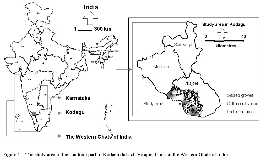
southern part of the district, Virajpet taluk , (Figure 1), where we carried
out most of our fieldwork.
Click on Image for larger View
Kushalappa
& Kushalappa (1996) have taken a systematic approach to studying sacred
groves of Kodagu. As part of a
study commissioned through the Karnataka State Forest Department, extensive
field surveys were carried out in sacred groves in order to assess tree diversity,
regeneration status and growing stock. In
addition, the study also attempted to measure the quality of forest in adjacent
protected areas in order to compare how sacred groves fare in comparison with
the nearby unbroken forest. This work has laid foundation for the subsequent
studies of sacred groves in Kodagu. Chandrakanth
& Nagaraja (1997), from a socio-economic point of view, have highlighted
why maintaining sacred forest patches for their religious significance is important.
While they have emphasised the benefits of this tradition, they have also stressed
that the tradition is under constant economic pressure, and the forests in sacred
groves suffer from the risk of degradation. Kalam
(1996), in his socio-historical study, has found historical evidence for degradation
of forest quality in sacred groves and supported his argument by presenting
case studies of sacred groves where such degradation has occurred. A
recent study by Garcia (2002) has emphasised that cultivation of lucrative cash
crops has been detrimental to sacred groves tradition and new management rules
are necessary. Based on his surveys
in sixteen sacred groves, one privately owned forest and the continuous protected
area, Garcia has claimed that sacred groves do not play any role in biodiversity
conservation (Coffeeland News 2003). Garcia
et al. (2003) have also argued that contrary to the romantic and idealized
image that has been portrayed in the literature, sacred groves in Kodagu are
not remnants of pristine forest; nevertheless, their conservation is important
for social and cultural reasons rather than biological or ecological.
| Review of earlier work |
A
recent publication by Ramakrishnan (2000) has made commendable effort to bring
together a multidisciplinary team of Kodagu researchers. While this publication provides an useful source of information
about Kodagu landscape, it has fallen short of identifying links between different
studies – for example, Moppert (2000) has succinctly presented the effects of
expansion of coffee plantations on landscape changes, but has failed to link
her study to that of Kalam’s (2000), commenting on modern-day encroachments
on sacred groves by neighbouring coffee plantations; and that of Bonn’s (2000)
explaining socio-economic dimension of encroachments on sacred groves.
Many
researchers tend to reach conclusions about “biodiversity” in sacred groves
although their study is often limited to diversity of trees, or at best trees
and other angiospermic plants. Garcia’s
claim that sacred groves do not play any role in biodiversity conservation (Coffeeland
News 2003) is, therefore, unsubstantiated. Not
only are the diversity patterns of trees uncorrelated with those of other life
forms (Bhagwat 2002), but also without rigorous comparison of diversity of multiple
taxa in sacred groves and in protected area, it is unreasonable to comment on
the value of sacred groves for biodiversity conservation. In
this article, the patterns of diversity in trees, birds and mushrooms are presented.
It shows that there is no congruence. Also, it emphaises that sacred groves
are important storehouses of non-timber forest products (including a variety
of mushrooms), useful for the livelihoods of some local communities.
While
sacred groves may be impoverished in endemic species of trees as compared to
the protected area (Garcia et al.
2003), their presence in the otherwise manmade and intensively cultivated Kodagu
landscape may mean that they have significant conservation value, such as for
species that are useful for the livelihoods of some local communities. In
other words, presence of sacred groves in the landscape is an insurance policy
for maintaining the integrity of the adjacent protected area. While ecological
patterns of species distribution in sacred forest patches are important, sacred
groves cannot be looked at in isolation from the surrounding landscape, a strategy
for landscape-level conservation in Kodagu is proposed in this article.
| Importance of landscape approaches |
Sacred
groves in Kodagu are patches of forest in a landscape that once-upon-a-time
might have had continuous tree cover. Their sizes range from a fraction of a
hectare to a few tens of hectares. The
smallest sacred grove in our study area was just 0.2 hectares, while the largest
was 48.1 hectares in size. In addition
to biogeographical processes, complex human–nature interactions have shaped
the modern Kodagu landscape – there are tall forests; forest patches; tree-covered
land where understorey is cleared for planting cash crops; and open paddy fields.
This means that an approach that
recognises the characteristics of the complex landscape matrix is necessary
for studying Kodagu landscape. Heuristic
frameworks in biogeography, such the equilibrium theory of island biogeography
(MacArthur & Wilson 1967) predicts, based on the observations of oceanic
islands, how biodiversity would be distributed in patches of various sizes and
at various distances from one another. Metapopulation Theory (Hanski & Gilpin 1991) predicts population
dynamics of species that occupy, breed, undergo local extinction within patches
and immigrate between patches. However, one of the main limitations of applying these theories
to terrestrial landscapes is that they do not recognise the role that landscape
matrix between patches plays in determining biodiversity within patches. Landscape
ecology (Forman & Gordon 1986), with its ability to recognise the role of
structure, composition, configuration and complexity of the intervening landscape
matrix provides a more suitable framework for studying biodiversity in sacred
groves. This is of particular relevance in Kodagu, where the sacred
forest patches are surrounded by tree covered landscape matrix in form of shade
coffee plantations that easily allow movement (of mobile organisms such as birds,
butterflies, small mammals, and even large mammals such as elephants where they
exist) and dispersal (of immobile organism such as trees, other plants and mushrooms)
between sacred groves. This means
that a study of biodiversity within patches cannot be separated from biodiversity
that exists between patches; consideration of the native tree cover in coffee
plantations and its role in maintaining biodiversity is, therefore, essential.
| Biodiversity |
Sampling was done in the localities along the boundary of the protected area – the Brahmagiri Wildlife Sanctuary in south-western Kodagu. The total geographical area of our study area was about 60,000 ha (600 sq. km). Coffee plantations occupied about 60% of the area, the protected area occupied about 30% of the area, and sacred groves occupied less than two percent of the total geographical area. The rest eight percent was occupied by paddy fields and other non-tree covered land uses. Sacred groves were at variable distances from the nearest boundary of the protected area and from one another. Coffee plantations were ubiquitous outside the protected area and in the landscape between sacred groves. After initial reconnaissance surveys, 58 localities (Table 1) were selected for sampling in the Virajpet taluk of Kodagu. Twenty-five sacred groves, 23 coffee plantations and 10 localities within the protected area were sampled for trees, birds and mushrooms in 1999 and 2000. The sampling scheme adopted here (Figure 2) was designed for providing a framework for inventories aimed at rapid assessment of biodiversity in more than one taxon. In the present study, the sampling localities were very variable in size – the protected area was uninterrupted and large; sacred groves were patchy; and coffee plantations, although contiguous, were composed of small individual land-holdings. In order to overcome the problem of variable sizes and differences in the biological and ecological characteristics of organisms in question, emphasis was on sampling randomly the same number of individuals (observations in the case of birds and mushrooms) at each site rather than sampling equal areas. An individual (for trees) is an ecologically more meaningful unit than an area (Condit et al. 1996). For assessing diversity of birds, numbers of observations are more meaningful for comparison than measures such as the time spent recording, which will result in different numbers of observations depending upon the time of the day when the sampling is carried out (Bibby 1998). Rapid assessment methods that make use of morphological characteristics of an organism for species identification (morphospecies, but referred to as ‘species’ for brevity in the rest of this article) are suitable for measuring diversity in a group such as mushrooms, for which shortage of expertise is compounded by the long time required to sort records down to the level of species (e.g. Balmford et al. 2000).
Table 1 – List of sampling localities – sacred groves,
continuous protected area, and coffee plantations in Kodagu. The localities are
identified by the abbreviated names of villages in which they occurred (Bg –
Beeruga; Bk – Badagarakeri; Br – Begur; Bt – Bettoli; Hg – Heggala; Ht
– Halligattu; Ic – Ichur; Kb – Kolathodu-Bygodu; Kd – Kunda; Kt –
Kottoli; Ku – Kuttandi; Pd – Poradu; Pl – Palangala; Th – Theralu; To
– Thora; Ts – T-Shettigeti; Vb – Vanbhadrakali-Hathur; Wn – West Nemmale);
the number at the end of each locality name represents the sampling reference
number.
|
Sampling
locality |
Latitude
– Longitude |
Altitude
(m) |
Patch
size (ha) |
Distance
from the protected area (km) |
|
Protected
area localities |
|
|
Continuous |
|
|
1. Bgrf31 |
11o
59’ 44” N, 75o 57’ 50” E |
870 |
> 10,000 |
0 |
|
2.
Bgrfr32 |
11o
59’ 44” N, 75o 57’ 50” E |
870 |
> 10,000 |
0 |
|
3.
Hgrf43 |
12o
08’ 00” N, 75o 45’ 42” E |
878 |
> 10,000 |
0 |
|
4.
Kurfn49 |
12o
05’ 24” N, 75o 50’ 02” E |
927 |
> 10,000 |
0 |
|
5.
Kurfs50 |
12o
05’ 22” N, 75o 50’ 03” E |
923 |
> 10,000 |
0 |
|
6.
Thrfc41 |
11o
59’ 07” N, 75o 53’ 55” E |
856 |
> 10,000 |
0 |
|
7.
Thrfn03 |
11o
58’ 48” N, 75o 54’ 47” E |
833 |
> 10,000 |
0 |
|
8.
Thrfs40 |
11o
58’ 45” N, 75o 54’ 40” E |
832 |
> 10,000 |
0 |
|
9.
Torfe36 |
12o
09’ 36” N, 75o 41’ 57” E |
857 |
> 10,000 |
0 |
|
10.
Torfw35 |
12o
09’ 36” N, 75o 41’ 57” E |
857 |
> 10,000 |
0 |
|
Sacred
groves |
|
|
Patchy |
|
|
11.
Bgdsg30 |
11o
59’ 02” N, 75o 56’ 52” E |
935 |
21.59 |
1.4 |
|
12.
Bkdsg26 |
12o
01’ 57” N, 75o 54’ 07” E |
855 |
9.4 |
2.7 |
|
13.
Brdsg21 |
12o
05’ 59” N, 75o 55’ 53” E |
812 |
1.3 |
5.3 |
|
14.
Brlsg01 |
12o
05’ 45” N, 75o 54’ 30” E |
799 |
2.4 |
1.7 |
|
15.
Btdsg42 |
12o
11’ 24” N, 75o 47’ 19” E |
879 |
12.1 |
4.8 |
|
16.
Hgdsg18 |
12o
08’ 40” N, 75o 46’ 04” E |
917 |
2.4 |
1.0 |
|
17.
Hglsge16 |
12o
08’ 35” N, 75o 46’ 07” E |
912 |
39.7 |
6.3 |
|
18.
Hglsgw15 |
12o
08’ 35” N, 75o 46’ 07” E |
912 |
39.7 |
6.9 |
|
19.
Htdsg57 |
12o
07’ 32” N, 75o 55’ 36” E |
822 |
8.9 |
8.2 |
|
20.
Icdsg53 |
12o
09’ 00” N, 75o 54’ 31” E |
858 |
4.0 |
8.0 |
|
21.
Kbdsg51 |
12o
09’ 55” N, 75o 51’ 37” E |
843 |
12.4 |
4.3 |
|
22.
Kdpaim54 |
12o
09’ 44” N, 75o 54’ 07” E |
966 |
6.6 |
8.6 |
|
23.
Ktdsg44 |
12o
11’ 35” N, 75o 46’ 03” E |
918 |
0.2 |
5.1 |
|
24.
Kudsg45 |
12o
06’ 10” N, 75o 51’ 53” E |
860 |
3.7 |
1.9 |
|
25.
Kuhdsg48 |
12o
06’ 38” N, 75o 52’ 08” E |
857 |
3.2 |
2.8 |
|
26.
Kulsg47 |
12o
06’ 20” N, 75o 51’ 50” E |
847 |
1.4 |
2.2 |
|
27.
Pdlsg27 |
12o
01’ 53” N, 75o 55’ 29” E |
870 |
7.1 |
4.9 |
|
28.
Pldsg13 |
12o
11’ 13” N, 75o 43’ 05” E |
930 |
2.1 |
2.5 |
|
29.
Pllsge08 |
12o
11’ 12” N, 75o 42’ 57” E |
935 |
48.1 |
1.4 |
|
30.
Pllsgw11 |
12o
10’ 55” N, 75o 42’ 56” E |
956 |
48.1 |
4.7 |
|
31.
Topaij39 |
12o
09’ 28” N, 75o 42’ 44” E |
910 |
NA |
1.6 |
|
32.
Tslsg58 |
12o
02’ 24” N, 75o 57’ 22” E |
820 |
14.0 |
6.4 |
|
33.
Vbdsg52 |
12o
09’ 11” N, 75o 52’ 27” E |
824 |
7.6 |
5.7 |
|
34.
Wndsg24 |
12o
01’ 07” N, 75o 57’ 12” E |
845 |
2.3 |
4.4 |
|
35.
Wnlsg22 |
12o
00’ 54” N, 75o 56’ 49” E |
849 |
18.8 |
4.3 |
|
Coffee
plantations |
|
|
Continuous |
|
|
36.
Bgcofd33 |
11o
59’ 02” N, 75o 56’ 52” E |
935 |
> 10,000 |
1.3 |
|
37.
Bgcofs34 |
11o
59’ 02” N, 75o 56’ 52” E |
935 |
> 10,000 |
1.4 |
|
38.
Bkcofc29 |
12o
01’ 57” N, 75o 54’ 07” E |
855 |
> 10,000 |
2.9 |
|
39.
Brcofj02 |
12o
05’ 45” N, 75o 54’ 30” E |
799 |
> 10,000 |
2.7 |
|
40.
Brcofn20 |
12o
05’ 45” N, 75o 54’ 30” E |
799 |
> 10,000 |
2.3 |
|
41.
Hgcofa19 |
12o
08’ 35” N, 75o 46’ 07” E |
912 |
> 10,000 |
1.2 |
|
42.
Hgcofu17 |
12o
08’ 35” N, 75o 46’ 07” E |
912 |
> 10,000 |
1.5 |
|
43.
Kdcofl55 |
12o
09’ 44” N, 75o 54’ 07” E |
866 |
> 10,000 |
8.3 |
|
44.
Kdcofs56 |
12o
09’ 44” N, 75o 54’ 07” E |
866 |
> 10,000 |
8.5 |
|
45.
Kucofp46 |
12o
06’ 10” N, 75o 51’ 53” E |
860 |
> 10,000 |
2.1 |
|
46.
Pdcofc28 |
12o
01’ 53” N, 75o 55’ 29” E |
870 |
> 10,000 |
4.7 |
|
47.
Plcofc10 |
12o
10’ 55” N, 75o 42’ 56” E |
956 |
> 10,000 |
3.4 |
|
48.
Plcofd12 |
12o
11’ 06” N, 75o 43’ 12” E |
910 |
> 10,000 |
1.2 |
|
49.
Plcofh09 |
12o
11’ 12” N, 75o 42’ 57” E |
935 |
> 10,000 |
1.5 |
|
50.
Plcofr14 |
12o
11’ 24” N, 75o 42’ 57” E |
902 |
> 10,000 |
2.1 |
|
51.
Thcofa04 |
12o
00’ 00” N, 75o 53’ 43” E |
847 |
> 10,000 |
1.8 |
|
52.
Thcofb05 |
11o
59’ 47” N, 75o 53’ 37” E |
865 |
> 10,000 |
1.7 |
|
53.
Thcofg06 |
11o
59’ 11” N, 75o 54’ 08” E |
836 |
> 10,000 |
8.8 |
|
54.
Thcofs07 |
11o
59’ 11” N, 75o 54’ 08” E |
836 |
> 10,000 |
8.0 |
|
55.
Tocofc38 |
12o
09’ 28” N, 75o 42’ 44” E |
910 |
> 10,000 |
8.0 |
|
56.
Tocofj37 |
12o
09’ 28” N, 75o 42’ 44” E |
910 |
> 10,000 |
7.0 |
|
57.
Wncofd25 |
12o
01’ 07” N, 75o 57’ 12” E |
845 |
> 10,000 |
4.5 |
|
58.
Wncofl23 |
12o
00’ 54” N, 75o 56’ 49” E |
849 |
> 10,000 |
4.1 |
Click
on Image for larger View
At
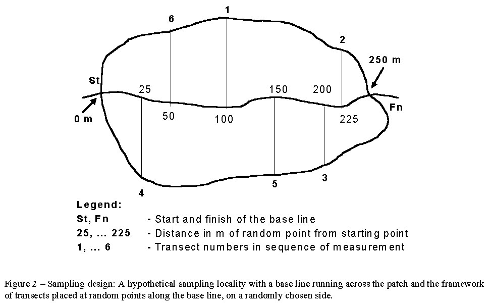
each locality, trees were sampled before birds and mushrooms. Prior to visiting the sampling locality (for tree sampling),
random numbers, in multiples of five, were generated. A base line was selected at each locality (marked by 'St' and
'Fn' in Figure 2), which often ran along a natural or man-made linear landscape
feature (e.g. a cart track, path, fence, boundary, stream) across the extent
of the area. Starting points of
individual transects were located on the base line in the same sequence as the
random numbers. For example, if
the first random number was 100, transect number one was placed at 100 m
from the starting point along the base line on a randomly chosen side – left
or right. After completion of sampling
along the first transect, the second transect was placed at the distance equal
to the second random number from the starting point.
The process was repeated until a sufficient number of trees had been
sampled at each locality. The base
line was demarcated by painting arrows on adjacent trees using blue oil paint
which allowed the relocation of the line easily when the sampling locality was
revisited in order to sample birds and mushrooms.
The direction of the base line was usually along the cardinal directions.
The vegetation transects were established exactly along a North-South
line if the base line was roughly East-West and vice versa.
Thus, at each locality, one base line and several transects running parallel
to each other and perpendicular to the base line provided a framework for sampling.
The start and the finish of each transect was marked and all trees ≥ 10
cm dbh falling within the boundaries of the transects were marked with blue
paint. Sampling for birds and mushrooms
was carried out later using the same framework.
In order to make the sampling design compatible for inventories of all
three taxa under investigation and to consider a possibility of re-measuring
diversity for monitoring in future, this sampling framework was found to be
the most suitable.
| Landscape structure analysis |
Spatial information is central to landscape ecological research. However, availability of detailed land use information is often problematic. Although detailed land use data are becoming increasingly available thanks to the modern remote sensing technology, they are expensive (Nagendra & Gadgil 1998). Furthermore, such information is not sufficiently detailed, nor are the Survey of India topographic maps (scale – 1:50,000 or 1:25,000). The problems in obtaining spatial information in India are further compounded by government regulations – many maps are restricted to military use and difficult to obtain. Village land survey maps (scale – 1:7920) are locally available from Land Revenue departments and relatively easy to obtain, but often very old, which were used as referenece maps. Forty-two land survey maps (scale – 1:7920) were verified using GPS surveys, and digitised using a GIS software package in order to generate a landscape map(Figure 3). The characteristics of the landscape surrounding sacred groves were measured. Using geographical information systems (GIS) it was possible to measure patch areas of sacred groves, their isolation from the protected area; and measures of integrity, heterogeneity and complexity of the surrounding landscape matrix. In addition to the landscape configuration, forest stand configuration was measured (Table 2).
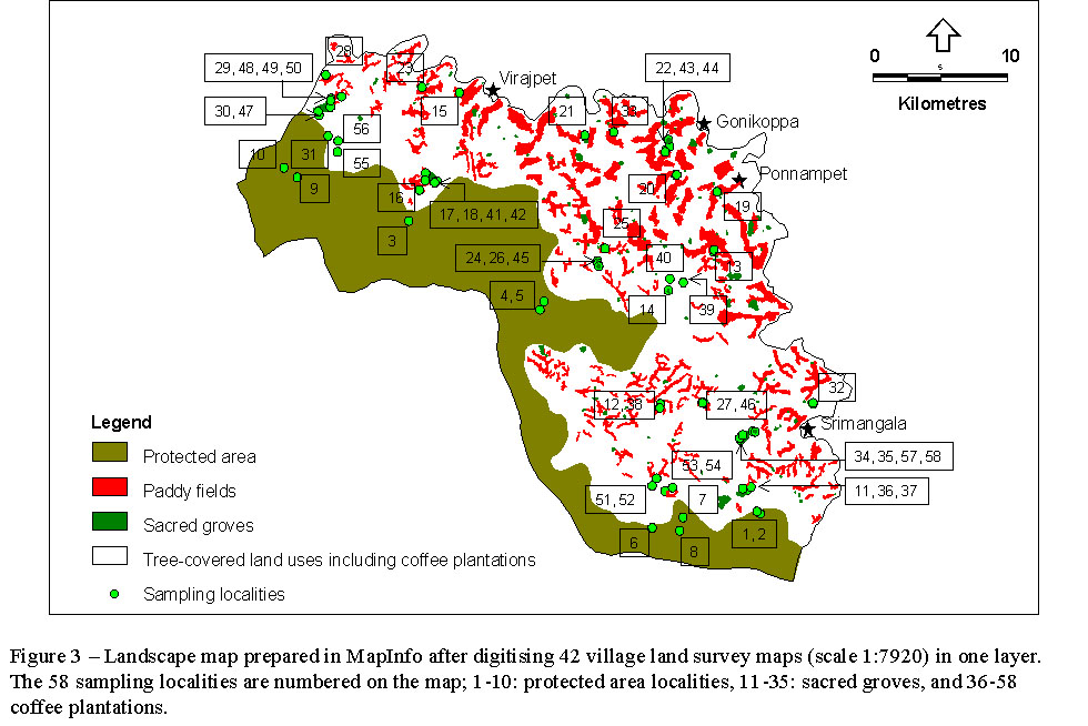
Table 2 – The variables of landscape structure and their ecological interpretations.
(A) Variables
of landscape configuration
|
Variable |
Description
of landscape parameter |
A
measure of |
|
DRF |
Distance from the protected area |
Isolation |
|
AT |
Percentage area of tree-covered land |
Landscape integrity |
|
NPT |
Total number of patches within a buffer[1] |
Landscape heterogeneity |
|
LET |
Total length of edges within a buffer |
Landscape complexity |
Note:
AT, NPT and LET were measured for 250, 500, 750 and 1000 m buffers.
(B) Variables of
forest stand configuration
|
Variable |
Description
of structural parameter |
A
measure of |
|
SD |
Number of stems ≥ 10cm dbh per hectare |
Forest structural complexity |
|
BAR |
Basal area range (5-95 percentiles) in sq. m |
Forest structural heterogeneity |
|
HTR |
Canopy height range (5-95 percentiles) in m |
Extent of disturbance to the ecosystem |
|
CCR |
Canopy-scope[2] measurement range (5-95 percentiles) |
Micro-habitat heterogeneity in the canopy |
|
LIA |
Number of lianas per hectare |
Micro-habitat complexity in the understorey |
[1] A buffer is a zone of a given distance surrounding a patch.
[2] The ‘Moosehorn’ (Garrison 1949) was re-designed as a transparent Perspex screen with a 20 cm cord attached to one corner. The cord is used to ensure that the screen is always held at the same distance from the eye. The screen was engraved with 25 dots, approximately 1 mm in diameter spaced 3 cm apart (centre to centre), in a 5 x 5 – square array. This instrument was re-named as a canopy-scope.
| Landscape structure and biodiversity |
CHAID
analyses gave a good preliminary idea of the measures of landscape structure
that may be responsible for determining diversity of trees, birds and mushrooms.
For example, how far a sacred grove
was from the protected area was found to be important for explaining tree
diversity, while how much tree cover is available in the surrounding landscape
explained best the diversity of birds. For
diversity of mushrooms, the most important variable appeared to be the
complexity of landscape surrounding sacred groves, which was also correlated
with the measures of humidity in the air (Bhagwat 2002).
The measures of landscape structure were then examined in further detail
in order to explore the effects on communities and species of trees, birds and
mushrooms (Table
3).
Table 3 – The effects of long-term landscape modification
and land management on trees, birds and mushrooms in Kodagu; an asterisk denotes
a significant (P < 0.05) difference; the sacred groves are
abbreviated as ‘Sacred’, the protected area as ‘Protected’, and coffee
plantations as ‘Coffee’.
|
|
Trees |
Birds |
Mushrooms |
|
Effects of landscape degradation in Kodagu on communities of organisms |
|||
|
Intensity of land management on diversity |
No effect |
No effect |
No effect |
|
Intensity of land management on number of unique species |
More species in Protected* |
No difference between Protected, Sacred and Coffee |
More species in Sacred* |
|
Patch size on diversity |
No effect |
No effect |
No effect |
|
Isolation on diversity |
Decline |
No effect |
No effect |
|
Intervening landscape matrix on diversity |
No effect |
Matrix in the immediate surroundings of patches important for explaining bird diversity* |
Matrix in distant surroundings important for determining diversity of mushrooms* |
|
Distribution of ecological groups |
|||
|
Habitat preference |
Deciduous trees increase and evergreen trees decrease with intensity of land management* |
Non-forest dwellers increase and forest dwellers decrease with intensity of land management* |
Mushrooms fruiting on wood less frequent and those fruiting on litter more frequent in Sacred* |
|
Body size in birds |
NA |
Large-bodied birds more abundant in Coffee and small-bodied in Sacred* |
NA |
|
Fecundity in birds |
NA |
Birds with low fecundity more abundant and those with high fecundity less abundant in Protected* |
NA |
|
Feeding guilds in birds |
NA |
Understorey insectivores less abundant in Coffee; nectarivores more abundant in Sacred* |
NA |
|
Mycorrhizal mushrooms |
NA |
NA |
More frequent in Sacred |
|
Distribution of species of conservation importance |
|||
|
Endemic |
More abundant in Protected* |
No difference |
No information |
|
Threatened |
More abundant in Sacred* |
Insufficient sample size |
No information |
|
Useful |
More abundant in Coffee* |
NA |
More frequent in Sacred* |
|
Medicinal |
More abundant in Coffee* |
NA |
More frequent in Sacred* |
| Species distribution in the landscape |
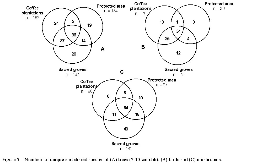
A total of 215 tree species, 86 bird species and 163 mushroom species were recorded in the protected area, sacred groves and coffee plantations. Their distribution in the three land use types is shown in Figure 5. Species that were found only in a single type are referred to as ‘unique’, those shared by any two of the three types are ‘shared’ and those found in all three types are referred to as ‘ubiquitous’. Forty-five percent of all tree species were ubiquitous, 26% shared, and 29% unique. Nearly 40% of bird species were ubiquitous, 35% shared, and 25% unique. About 39% of all mushroom species were ubiquitous, 21% shared, and 40% unique – 75% of which were unique only to sacred groves. The expected distribution of unique species was calculated by adjusting the species numbers to the sample sizes in the respective land use types. The observed number of unique tree species was higher than expected in the protected area but lower in the sacred groves (χ2 test, χ2 = 6.992, df = 2, P = 0.0195). Coffee plantations had nearly the same number of observed and expected tree species. The observed numbers of unique bird species were not significantly different to the expected numbers (χ2 test, χ2 = 2.631, df = 2, P = 0.0977) in any of the three land use types. The distribution of mushroom species between the three land use types was significantly different from expected (χ2 test, χ2 = 26.262, df = 2, P < 0.0001) due to the high numbers found in sacred groves.
Click
on Image for larger View
The
distribution of ecological groups of trees, birds and mushrooms; as well the
distribution of species of conservation importance are listed in Table
3. The intensity of land
management (protected areas were considered as the least intensively managed
land use; sacred groves were considered to have moderate management intensity
and the coffee plantations were considered to have the highest intensity of
management) caused an increase in deciduous trees and a decrease in evergreen
trees; an increase in non-forest dwelling birds and a decrease in forest dwellers;
an increase in the frequency of mushrooms fruiting on litter and a decrease
in the frequency of mushrooms fruiting on wood.
Large-bodied birds were more abundant in coffee plantations and small-bodied
birds in sacred groves; birds with low fecundity were more abundant and those
with high fecundity less abundant in the protected area; the understorey insectivorous
birds were less abundant in coffee plantations and nectarivorous birds more
abundant in sacred groves. Mycorrhizal
mushrooms were more frequent in sacred groves.
The useful species of trees and those with medicinal properties were
more abundant in sacred groves; and useful species of mushrooms and those with
medicinal properties were also more frequent in sacred groves. While
endemic trees were more abundant in the protected area, threatened trees were
more abundant in sacred groves.
| Conservation aspects |
While
habitat specialist, endemic species might have been lost from forest patches
in the managed landscape of Kodagu, modern land uses harbour populations of
useful species (cf. Boraiah et al.,
2003). Traditional systems of conservation
are still valuable for offering protection to certain elements of diversity
including endemic and threatened species.
On the other hand, species such as those endemic to the Western Ghats
may require large unbroken forest in the protected area. The resource availability in the already degraded landscape
in the form of useful species may be important in removing the pressure of resource
use from the protected area to the traditionally managed land, thus achieving
a better conservation of a strictly protected area.
A combination of approaches is therefore necessary for conservation of
biodiversity in Kodagu; maintaining the integrity of the three land use types
studied is critical for the conservation of Kodagu landscape.
While the long-term human use has caused landscape degradation, the protected
area is still relatively intact. It
accounts for the protection of species with special habitat requirements – 63%
of trees species unique to the protected area are endemic, in contrast to only
10% of those found in sacred groves and coffee plantations, but not in the protected
area. At the same time, sacred
groves and coffee plantations together have successfully protected trees useful
to the local people – 84% of the tree species found in sacred groves and coffee
plantations, but not in the protected area, produce useful non-timber forest
products.
The
protected area is instrumental in protecting many species of conservation
importance – the Western Ghats’ endemic trees, birds with low fecundities
and possibly mushrooms with co-evolved interdependencies such as the one found
exclusively growing on elephant dung in the Theralu and Thora forest reserves
(personal observation). Conservation
of such species cannot take place without the protected area.
The removal of coffee plantations from the Kodagu landscape or the
replacement of native shade trees with exotics would result in rapid depletion
of biodiversity. The disappearance
of trees in coffee plantations that are useful and have medicinal value to the
local people would result in resource-use pressure on sacred groves and the
protected area. The matrix of
coffee plantations is likely to change in future, in species composition, unless
dwindling populations of native trees are replaced by proactive planting.
In the present study, sacred groves were found to be situated in a
variety of habitats – some were adjacent to water-logged paddy fields, others
were on hill-slopes and still others on tree-covered hill tops.
These patches protect a greater variety of habitats than a single
protected area would (e.g. Quinn & Harrison 1988; Lapin & Barnes 1995).
The loss of sacred groves would result in the decline of landscape-level
heterogeneity that these patches provide.
A
study of butterfly diversity in the southern Western Ghats found that about 46%
of the butterfly species are in low abundance in a few patchily distributed
locations. Species such as the
Travancore Evening Brown (Parantirrhoea
marshalli Wood-Mason) or the Malabar Banded Swallowtail (Papilio
liomedon Moore) are restricted to low elevation evergreen forests in the
southern Western Ghats that are excluded from the protected area network (Soubadra
Devy & Ganeshaiah 2001 pers. comm.).
In the present study, tree species such as Actinodaphne
lawsonii Gamble; Hopea ponga (Dennst.)
Mabberley; Madhuca neriifolia (Moon)
H.J. lam; and Syzygium zeylanicum (L.)
DC., that are listed as threatened in their home ranges (FRLHT 1999; IUCN 2000),
were unique to sacred groves. Other
threatened species such as Michelia
champaca L. and endemic species such as Pittosporum
dasycaulon Miq. were found in sacred groves and coffee plantations but not
in the protected area. While these
species are restricted to the low-lying areas, the current protected areas along
the western hilly region of the district do not include their preferred
habitats. In addition, bird species
such as the Loten’s sunbird (Nectarinia
lotenia L.), an endemic, and the Nilgiri Flycatcher (Eumyias albicaudata (Jerdon)), an endemic and threatened bird, were
restricted to sacred groves and coffee plantations. Forty-nine out of 163 species of mushrooms were unique to
sacred groves. It is likely that
the landscape outside protected area in Kodagu shelters species of some groups
of organisms that cannot be protected within the formal protected area network (Bhagwat
1998), and conservation of such species will require protection of land outside
the protected area. Although we
acknowledge that the examples above are only illustrative and more
species-specific data and intensive field research are necessary to determine
occurrences of individual species and to substantiate the findings of the
present study, these examples offer basic information on which future studies
can be based; our investigation has provided a practical directive to the sacred
groves research in Kodagu.
| Conservation strategy |
It
would appear that Kodagu has been successful in maintaining a balance between
conservation and development through the formal (state-initiated conservation)
and the informal (community-based conservation) systems, besides a comparatively
thriving coffee economy (private enterprise) that makes the region prosperous.
However, currently, there are threats to the integrity of the protected
area as well as of sacred groves and coffee plantations.
Unplanned
forestry activities and illegal smuggling of timber has made the current system
of protection of the forest reserve vulnerable. Despite
a moratorium on logging in hilly areas imposed by the Indian government since
1983 (MoEF, 1985) timber is still illegally extracted from these forests. Furthermore,
for cultural reasons, gun ownership is legal in Kodagu (Ponnappa, 1997), which
has exacerbated illegal hunting. While
the government has always been the custodian of the sacred forests, the local
people have had a say in their management (see Haller, 1910). The extent and quality of the woodland in these sacred forests
is reported to have suffered due to their misappropriation under the ‘open
access’ regime of the revenue department (Kalam, 1996), in accordance with the
‘tragedy of the commons’ model described by Hardin (1968). This has been attributed to the careless policy changes and
unprecedented tenure transfer (from the Forest to the Revenue Department)
between government departments resulting in the confusion among local people
about the actual ownership and exact boundaries of sacred forests (Kalam, 2000).
In addition, the unobtrusive
temples in sacred forests have been replaced by sophisticated concrete
constructions (Chandran et al., 1998) in the process of Sanskritization
(transformation of local belief system and its homogenisation with the main
stream Hindu religious practice). This
has caused decline in the quality of vegetation within sacred forests. After
coffee trade was privatised in the mid-1990s, the small landowners were able to
sell their produce on the free market making the venture more profitable. Subsequently, the Human Development Index (Narayana, 1999) of
Kodagu increased far beyond the rest of India. In order to maintain the increased standard of living,
valuable native tree species were illegally felled for timber. In
Kodagu, a growing demand for coffee on the free market encouraged planters to
intensify coffee cultivation resulting in modification of forest wherever
circumvention of local rules and regulations was possible. Simultaneously,
paddy fields were converted into ginger, banana and areca nut plantations. In
addition, sacred forests were encroached by landowners in their neighbourhoods
(Bonn, 2000).
| How to go about maintaining biodiversity in Kodagu? |
A
three-prong strategy for the conservation of biodiversity in Kodagu is proposed.
This includes preventative measures for activities that result
in the modification and supportive ones for those that achieve conservation,
so as to accomplish the maintenance of biodiversity at the landscape level.
Prevention
of hunting and timber-smuggling from the forest reserve
While
Akbar Sha (1987) and Forest Survey of India (1995) have mentioned the role of
the forest reserve in protecting the populations of large mammals, illegal
hunting and timber smuggling are the two activities that currently pose the
greatest threat to the forest reserve. The following three solutions are
proposed.
(1)
Control of illegal hunting and logging
Currently
there are regulations designed to prevent hunting and logging – the moratorium
on logging since 1983 and the Wildlife (Protection) Act amended in 1991. However, the Forest Department has insufficient manpower to
police illegal activities because of the vast expanse of the forest reserve. It
is essential to resurvey and to consolidate the boundaries of the forest reserve
as the first step. Along with a
strong legislation at the state level, governments should develop and implement
innovative incentives to interest local communities in forest stewardship (Gadgil,
1992; Alcorn, 1996). The latest developments in India, the Biodiversity Act,
2002 and the National Biodiversity Strategy and Action Plan, NBSAP (2004) that
comply with the international initiatives such as CBD, TRIPS (GATT) and CITES
are important steps. The co-operation in preventing and monitoring illegal
forest exploitation should be linked to concrete benefits (Glastra, 1999). Currently,
there is a practice of recruiting members of the local community as temporary
‘forest watchers’ in Kodagu in return for small monetary compensation. The government should introduce more secure employment as
incentive for the qualified local inhabitants to work as guards and officers in
the Forest Department. In order to
secure the forest reserve from illegal logging, other measures such as the
certification of timber should be enforced.
(2)
Control of recreational hunting by local people
The
depletion of wildlife is partly attributable to recreational hunting by local
people. It has been a common
experience that management systems are likely to fail if there are changes in
technologies, such as the introduction of guns (Redford, 1992), although such
changes are inevitable when there is technological revolution in the world
outside. One of the ways for
tackling this problem could be to implement changes in the legislation for
unrestricted licensing of guns in Kodagu. The
licensing legislation should be able to recognise those who are in real need of
guns for self-defence and subsistence.
(3)
Alternative sources of timber for local people
Jennings
et al. (2000) have argued that the only viable strategy for conservation
of Mahogany (Swietenia macrophylla
King) forests in the Brazilian Amazon is to find sustainable livelihoods
for rural populations. In Kodagu,
unless local people have access to timber, conservation of the rest of the
forest area cannot be effectively implemented. The
coffee plantations in Kodagu are a valuable source of timber and non-timber
forest products, and will continue to be so if managed responsibly. Trees do not regenerate in coffee plantations because of
intensive land management, thus coffee plantations are likely to change in
future, in tree species composition. Therefore,
proactive planting of native timber trees by coffee plantation owners is
essential.
Maintaining
the integrity of coffee plantations
Larson
& Bromley (1990) have suggested that when market prices are exogenous and do
not reflect local scarcity, intensified agricultural production to meet
subsistence needs can lead to resource degradation. In
Kodagu, the privatisation of coffee market has had exactly this effect. The
following three measures are proposed in order to maintain the integrity of
coffee plantations.
(1)
Revitalisation of co-operative institutions
The
co-operative institutions such as The Coffee Board that used to exist in the
late 1990s are now defunct. The
privatisation of coffee market and modification of the native tree cover have
advanced hand-in-hand because the planters look at valuable native trees as an
alternative source of income when coffee prices dwindle. Co-operative
institutions are necessary to regulate coffee prices in the domestic market as
well as to bargain for good prices so that small planters have a stable income. In
this way, there will be fewer fluctuations in coffee prices, an assured income
for small planters and control of the depletion of native trees in Kodagu.
(2)
Disincentives for planting exotic trees and support for planting native trees
Evidence
form Latin America suggests that although shaded coffee plantations help to
preserve biodiversity (Greenberg et al., 1997) a recent trend among
planters, of replacing native trees with exotics, has been motivated by
increased coffee yields per hectare. In
Kodagu better irrigation facilities have allowed farmers to fell native trees
(which retain moisture in the plantations due to their dense foliage) and
replace them with exotics (which often have sparse canopies). Trees
such as Silver Oak (Grevillea robusta
Cunn.) have straight boles, which can be easily used to train black
pepper (Piper nigrum L.)
vines, an important source of additional income for coffee planters. A
system of sanctions – in form of higher taxes and no subsidies – on planters
who use exotic trees in coffee plantations (and thereby violate ecological
consideration in plantations management) could be enforced in order to prevent
the native tree cover from dwindling further. On the other hand, plantation owners could be encouraged to
maintain tree cover of native species because of its benefits to wildlife. In
order to facilitate this, the government should make available saplings of
native shade trees from the State Forest Department nurseries. The
government can develop incentive systems by way of cash rewards, reduced taxes,
greater subsidies etc. for those landowners who employ ecological consideration
in plantations management.
(3)
‘Biodiversity-friendly’ coffee cultivation
It
has been shown in South America that if the local landowners reach some basic
level of economic security, they become interested in ecological sustainability,
long term environmental planning and biodiversity conservation (Southgate &
Clark, 1993). Gobbi (2000) has
suggested that in El Salvador, for biodiversity conservation in shade coffee
plantations to be viable, incentives to small farmers from the government are
necessary. These could be in form
of tax reductions, loan facilities, subsidies and a secure market for
biodiversity-friendly coffee. For
such cultivation practices to be successful in Kodagu, it is necessary that the
government takes interest in the issues of small-scale farmers in order to
encourage them to help biodiversity conservation. Furthermore,
certification of coffee plantations by setting standards for sustainable
management can encourage planters to grow coffee in a biodiversity-friendly
manner. The recent efforts in
Kodagu of organic and biodynamic coffee cultivation are right steps in this
direction. In addition to this, the
market access of certified products should be facilitated by specific government
policies and appropriate legislation; and market-driven mechanisms i.e.
effective marketing of ‘biodiversity friendly’ coffee in the international
market can complement the policies and the legislation.
Participatory
management and conservation of sacred forests
Miranda
& LaPalme (1997) suggest that if there is a strong tradition of
community-based ownership or customary rights, governments should take advantage
of such relationships for effective biodiversity conservation. Despite
the disputed effectiveness in biodiversity conservation, community-managed
traditional reserves are one of the few mechanisms available that allow local
groups to manage natural resources over the long term and to achieve a
sustainable linkage between conservation and development (Brandon, 1997). The
following three steps can help in achieving better management of sacred forests.
(1)
Official recognition of sacred forest traditions
In
modern-day India, although many traditions are eroding, a large number of sacred
forests are still conserved through taboos and religious beliefs. Chandrakanth
et al. (1990) suggest that such sacred acts should be recognised by the
government. Bhatt & Kothari
(1997) identify the incompleteness of the IUCN protected area categories and
suggest an additional category, ‘Community Reserve’, that is appropriate in
the Indian context. It is
recommended that such areas should be allocated mostly for the protection of
traditional conservation practices, besides controls on limited resource use and
protection against outside commercial forces. While
official recognition at the national and the international level is important
for land-tenure security of sacred forests to the stakeholder communities,
participation of local people in the management is also essential.
(2)
A system of rewards for effective protection and a mechanism for sharing of
benefits
A
large number of sacred forests in the southern part of Kodagu (study area) are
still well protected. Maintaining
sacred forests is important to the local people as well as to the community
outside (Chandrakanth & Nagaraja, 1997) because of the cultural and
spiritual appeal that such landscapes have (Posey, 1998). However,
sacred forests are currently under threat of encroachment by coffee plantation
owners. In such a situation, a
system of rewards may work for their effective protection (Gadgil & Rao,
1994). The success of protection
could be assessed periodically by a panel of impartial judges, and the village
committees that are making sincere efforts at conserving their village sacred
forests could be rewarded by the State (Chandrashekara & Sankar, 1998). The
funds thus generated will help local people to undertake development activities
in villages. Non-governmental
organisations in Kodagu have a very good rapport with the local people. Their involvement in co-ordinating the system of positive
incentives is essential. While the
ownership of sacred forests should rest initially with the State Forest
Department, in order to avoid idiosyncratic management decisions (such as
misappropriation of land for other land uses) by individuals or committees,
representatives from the local community should be involved in making decisions
about access to the resources in such forests, so that no particular social
group can monopolise their management. Sacred
forests are important resources for non-timber forest products. Local
people depend on them for fuelwood, green fodder, medicinal herbs and other
livelihood necessities. An
organised system for harvesting, utilising and marketing such products is
essential. It should be recognised that the local people will not be able
to operate entirely on their own – the State should, apart from facilitating
their efforts and assisting with planning and management, oversee the smooth
running by resolving conflicts among the local communities. The profit generated from such enterprises should be shared
equitably between the State and the local community. There is an existing 90:10 resource sharing arrangement
between local communities and the State forest department for dead and fallen
trees. Such efforts need to be
complemented by appropriate legislation that can provide the necessary
land-tenure security (such as devolution of ownership to those local village
committees who have been successful in conservation of their sacred forests) and
resource-use rights to local communities, while recognising local peoples’
rights as a precondition (see Chambers et al., 1989).
(3)
Towards joint planning and management
Khare
et al. (2000) have found that foresters and villagers in some parts of
India view Joint Forest Management (JFM) very differently – many forestry
department officials see JFM primarily as a means of ensuring the rehabilitation
of degraded forests, while village communities view it as a solution to the
growing shortage of biomass, a means of obtaining the daily requirements of
forest products and a way to increase income. Therefore,
it is necessary to bring foresters and villagers together to initiate dialogue
and to reach agreement on the objectives of JFM of sacred forests. Currently, JFM is not recognised as a way to manage government
protected areas in India. In Kodagu,
no co-ordinated efforts have been undertaken by the government departments,
communities and institutions to develop and implement conservation strategies
for sacred groves (Gokhale et al.,
2004). The State Forest Department
should explore ways in which the JFM philosophy could be used in managing the
forest reserve in Kodagu.
Recently, there have been some serious attempts in Kodagu at adapting JFM to the local socio-cultural setting – a scheme of joint forest planning and management of sacred forests, which was proposed through a public initiative, has been accepted by the government. This scheme proposes to form a federation of sacred forest committees (who look after the management of local sacred forests), also consisting of local forest officers and community leaders. In order to mediate the negotiations between foresters and villagers, impartial representatives from the local College of Forestry and active non-governmental organisations are also members of the committee and participate in meetings (Kushalappa et al., 2001). Efforts such as this will be important in protecting the integrity of the cultural landscape in Kodagu.