Dynamics of Foreshore along Karwar Beach , Central West Coast of India |
||
| Back | Shramik Patil and U.G.Bhatt, Dept of Marine Biology, KUPG Center, Kodibag, Karawar |
Next |
Foreshore dynamics of Karwar beach along the central west coast of India (14° 50'N and 74° 07') was monitored by way of the profiling method during January to September 2006 in order to understand the nature of beach and magnitude of erosion and accretion process in space and time.
The paper presents information on erosion and accretion at three stations in Ravindranath Tagore beach, Karwar during pre monsoon and monsoon period starting from January to September 2006. The study revealed that the beach experiences maximum sediment storage around April May, followed by rapid rate of erosion with the onset of the southwest monsoon wind and resultant waves. Calm condition prevailed during the other months. Tropical cyclones produce large rainfall and strong winds, which generate high-energy sea waves, resulting in severe damage on land and sea. The present study site was found to face considerable erosion during monsoon in recent years. Station no 1 and 3 experienced higher degree of erosion than station no 2.
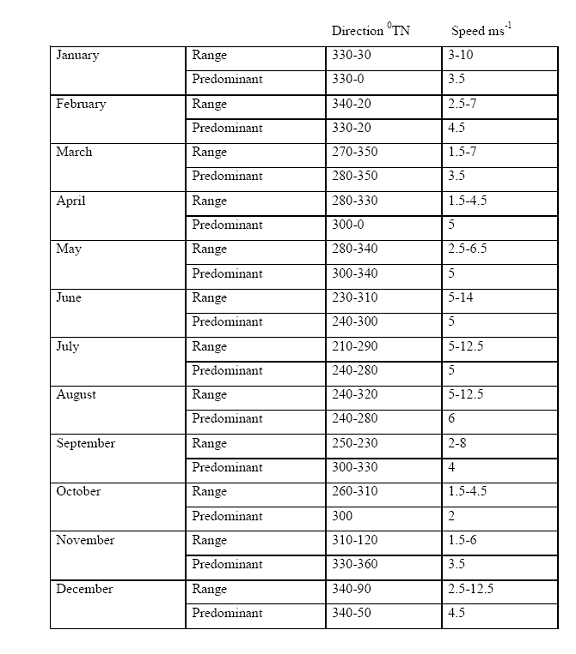
Values of wind speed, wind direction and rainfall are also discussed to substantiate the observations.
Introduction
Stability of a beach can be assessed from the profile changes during rough and fair weather seasons and can be monitored by recording the winds, waves, currents, tides breaker characteristics, sediment characteristics. If the beach material is washed away during the rough weather season, they are redeposited during fair weather. Thus, erosion and accretion are continuous processes.
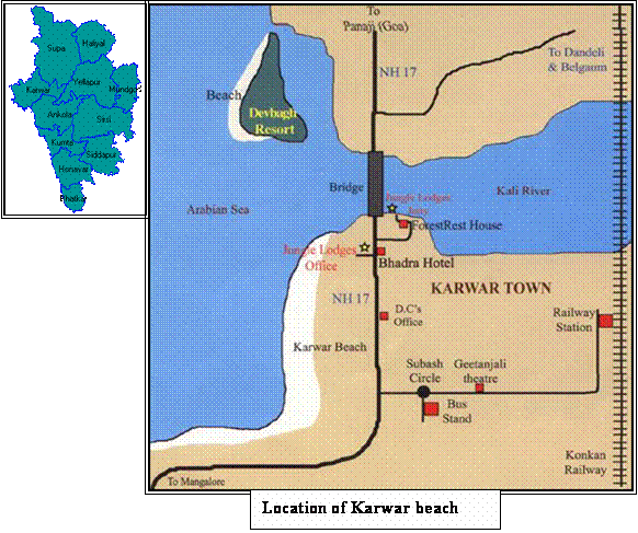
Karwar is one of the important coastal towns along the east coast of India situated at latitudes 14 0 50' and longitudes 74 0 07' which is known for fishing and recreational activities. The sandy beach situated at western side having a length of about 3.2 kms is quite interesting to study in relation to the beach processes which are contracted by various factors. Earlier a channel was made for ships to enter the harbour, which is adjacent to the shore. Wave pattern changed in that area and it caused severe erosion in the Tagore beach area since then.
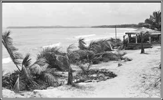
The pre-monsoon of 2006 (30 th May) witnessed cyclonic wind in the coastal Karwar, and considerable erosion occurred at various stretches of Karwar coast. The Tagore beach is one such area where the tress was uprooted and concrete structures erected because recreational irruption crumbled. The beach profile recorded before and after the storm has given a clear picture of the erosion / accretion pattern of the sting area.
Morphology of the coast
At the right, the kali estuary opens its mouth into the sea at left fishing harbour; to stop strong waves, a stone wall is constructed at the side of the harbour. THe harbour is protected by a big hill. The highway passes just a few metres from the coast. A garden is developed in the Tagore beach at left and at right the mini train is started for children, one Navy ship INS Chapal is made a museum. At the side of this marine aquarium, and after that up to kali estuary, the whole coast is guarded by cajurina trees. The Karwar coast is protected by small islands like Karumgad (7 km away from karwar coast), Light house (14 Km). sequentially 1 st is Devgad island (Oyster rocks) 2 nd Sunsi island (Madlingad), Pig island, etc.
The whole Karwar beach is covered with sand dunes. Near the Kali river mouth behind P.G. Centre the beach becomes comparatively wider and more amount of sand dunes are grown there. Two major sewage drains are open in the sea one is near the London Bridge and another one is near the mini train area. This beach is totally sandy that's why no rocks are found there except in monsoon small stones are scattered on the whole Karwar beach.
The general orientation of the Karwar beach in N-S direction. The sediment found on the beach is fine in nature. The total length of the beach is 3200 m and the width varies from 70-170 m. This beach is open type and the nature of the beach is moderate. (G.N.nayak.1986).
Methods and observations
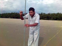
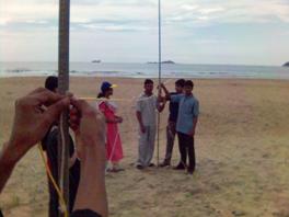
Changes in the beach are recorded at three stations (fig 1) at Tagore beach along each profile, reading was taken at suitable intervals till low tide line. The profile is taken by emery method. Two poles at about three metre length were used for measuring beach profile wind and rain data is recorded monthly.
The west coast of India is subjected to the depressions or the storms originating in the Arabian Sea . The highest numbers of cyclonic storms occur during months of Jun to July. In May, wave generates along shore current towards northeast. During study period in 27-28 May changes in wind and wave directions are observed and in 29 th May, the Sea becomes very rough due to strong winds. The maximum speed of wind observed in cyclonic period was 51 kmph and the observed breaker height is more and beaker time is less.
During this period, wave approached this stretch of the coast from south west in contrast to that on 29 th and 30 th May all along the beach breakers with height of 1.5 to 2.5 metres with period 5 to 6 seconds making the angle to the shore lead to increase long shore currents. Due to these strong wave attacking on the beach, the dunes present on the beach are damaged and the lighter sand particles carries off shore and along shore leaving heavy sand on the beach.
During the period of cyclone in 29 th May a Mining ship; Ocean Seara hits the oyster rocks and breaks it leading to oil spill and a patch of oil is seen all along the Karwar coast.
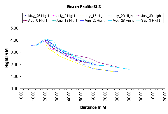
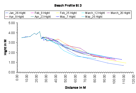
The variations in beach profiles taken on the beach at three stations in study period is given below.
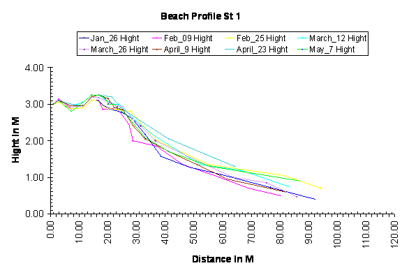
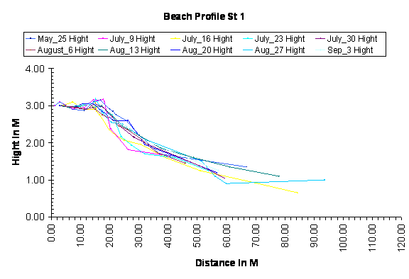
The beach profile of station no 1 is given below Figs.
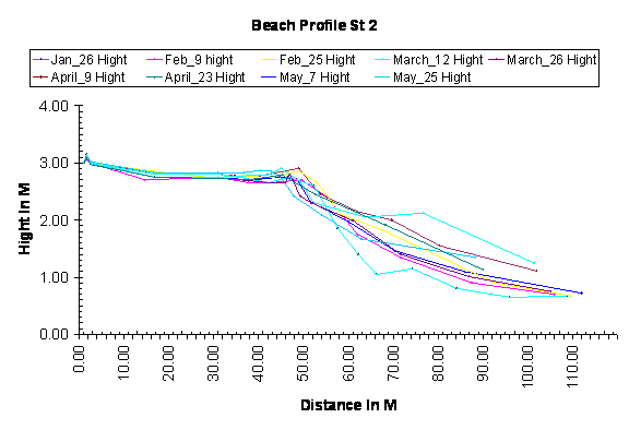
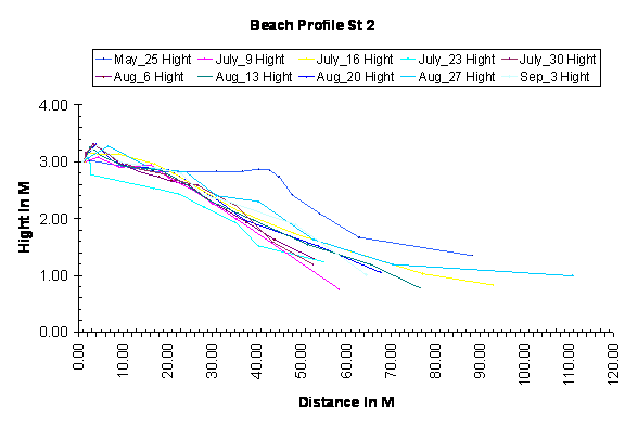
The beach profile of station no 2 is given below Figs.
The beach profile of station no 3 is given below figs.
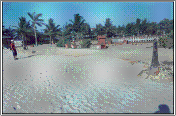
The photograph showing erosion occur at Tagore beach st. no 1
 |
 |
 |
 |
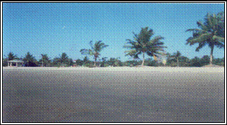
| The photograph showing location of station no 2 |
|
 |
 |
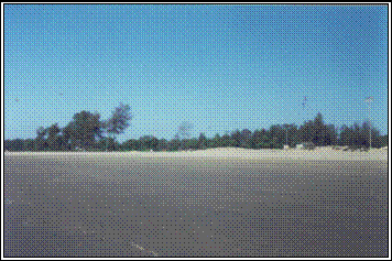
The photograph showing location of station no 3 |
|
The mean size of sediments analysed are In January 1.17, February 1.53, March 1.65, April 1.67, May1.71, June1.82, July 2.06, August 1.59, September 2.03.
Predominant winds: direction and magnitude in Karwar area
Result and discussion
The studies on the Karwar beach indicate that, the time of maximum erosion during the year occurring at different places in different months as indicated as the observed lowest elevation of beach profile. This difference in time of maximum erosion in along Karwar beach is attributed to plants; in general, Karwar beach undergoes erosion during southwest monsoon and accretion during post monsoon (LaFord & prasada Rao, 1954) considering the level of maximum erosion of the year as datum. The quantity of material deposited along the length of beach in April and May is maximum. The Diagram shows that the stations 1, 2 and 3 experimented several erosion quantitatively more than annual maximum erosion was lowered by 1-2 metres. The plantation and dunes experienced due to increased wave run-up leading to vertical cuts of 1 to 2 metres. Particularly erosion is very high in station no 1 and 3 because these areas are filled with red soil and plantation. While station no 2 is open and wider than the other two. At station no 3 the rocks usually buried in the sand were exposed. The narrow width at station no.1 the waves attack on the edges of garden and the coconut plants are washed away and it caused damage to adjacent properties also. Due to red soil used for construction of garden and of vertical steep slope.
Comparing the quantity of beach sediment in April May 2006 and June July 2006 it is understood that the beach has experienced several erosions due to cyclone. From these observations taken the little deposition and beach started to restore in one month consequently in the remaining part of the beach erosion continued and lost additional quantity of sediment. A study by Dr. G.N. Nayak on one location along this beach in December to January 1982-83 indicate the high rate of deposition. In contrast, the study reveals the significant variable rates of deposition particularly after the beach is subjected to such severe cyclonic storms. This is probably due to the variation in wave energy expended on the elastic boundary of the beach.
Refrences:
Studies on beach changes at Vishkhapatnam P.Chandramohan, T.V. Narasimha and D.Panakala Rao. Regional centre of national institute of oceanography, Waltair, Vishakhapatnam . (1982)
LaFend and R. Prasada Rao, (1954) Beach erosion cycles near Waltair in bay of Bengal. Andhra university. Memories in oceanography.
Stability and safety of Anjuna Beach Goa. G.Narayana Swami, V.V.R.Varadachari. National institute of oceanography, Dona Paula, Goa 403004
Beach changes at Vishkahpatnam due to cyclone of May 1979 P.Chandramohan Rao. Regional centre of national institute of oceanography, Andhra university campus, Waltair, Vishakhapatnam-530003. (1983)
Studies on morphology, texture and mineralogy of the beaches along north Karnataka coast, around Karwar India . G.N.Nayak.(1986).