 |
|
|
|
GISdevelopment > Application > Environment > Conservation & Monitoring Overview | Conservation & Monitoring | Planning & Policy | Wetland Management | Wildlife Management | Forest Fire Management | Water Pollution | Air Pollution | Climate Change | Relevant Links Biodiversity in the
Western Ghats Finally, at the most detailed scale of analysis,
IRS 1B LISS 2 data of March 1993 was purchased for a single
landscape of 27.5 sq. km from Siddapur taluk of Karnataka (400 - 600
m altitude, 14°16’- 14°19’N latitude and 74°52’- 74°54’E longitude).
Supervised and unsupervised classification of this imagery mapped
the landscape into seven ecotope types. 246 quadrats of 10 by 10 m
were distributed in the landscape, and used to record the tree layer
species distributed in these seven ecotope types. Within these,
sub-quadrats of 5 by 5 m and 1 by 1 m were used to record the
angiosperm species (excluding grasses, which could not be accurately
identified in the field) present in the shrub and herb layers
respectively. Analysis of species composition of quadrats belonging to various ecotope types determined that ecotope types as identified by supervised classification differ significantly in their species composition. However due to increased misclassification, ecotope types identified by unsupervised classification did not differ significantly in their species composition. Discussion This case study of the Western Ghats - West Coast moist forest region of India thus demonstrates the applicability of a multi-scale methodology employing satellite-based classification as well as field surveys, using a nested hierarchy of classification of ecological entities, for assessing species diversity. This study establishes the linkages between these seemingly disparate scales of analysis. Classification at the scale of the Western Ghats delineates ecomosaic types, which differ significantly from each other in their composition and configuration of their constituent ecotope types, as determined by classification at a finer scale. In turn, these ecotope types differ significantly in their species composition, as determined from field sampling. Based on this, a strategy for biodiversity assessment and monitoring at regular intervals of time can be outlined for the Western Ghats and western coast of India. Ecomosaic level classification produces a map of 205 patches belonging to eleven ecomosaic types. For each ecomosaic type, the identification of 5-10 landscapes is proposed, located in different patches. This set of 50-100 landscapes, of the order of 25-50 km2, can be mapped to the ecotope level, using four band IRS LISS 2 or LISS 3 imagery. At a still lower scale, within each landscape, quadrats of 10 by 10 m may be used to sample plant distributions on ground. A schematic outline of the methodology proposed, encompassing a range of different scales of observation, and a combination of remotely sensed data and field information, is depicted in Figure 1. 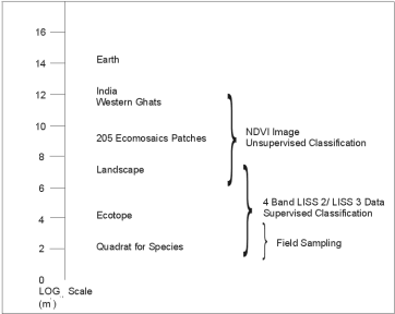 Fig 1: Proposed scheme of biodiversity investigations at diferent scales. Modified with permission from Current Science 75(3): 264-271 In the present classification of twelve landscapes, a total of twenty-three ecotope types were encountered. For the entire Western Ghats however, one may expect to find about 30-40 ecotope types, since in this study a few regions of the Ghats such as the high altitude shola-grasslands, were not investigated. For these 30-40 ecotope types, field sampling of various organisms, including but not restricted to plants, butterflies and birds, can be used to establish the set of species that are found associated with specific ecotope types. Within these landscapes, one must also investigate the extent to which latitude, longitude, topography and climatic factors influence the variation in species composition that is unexplained by ecotope distribution - for which purpose GIS will prove very useful. Regular monitoring of this set of landscapes, at 2-3 year intervals, along with repeated field inventories, will enable us to monitor changes in biodiversity. Mapping logical Sciences over the past five years with the Western Ghats Biodiversity Network, a network of college teachers and students who have aided us in this investigation, we believe such a scheme to be practically feasible, in a decentralized fashion. Previous large scale studies which use remote sensing for biodiversity assessment have been mainly carried out in the relatively species poor and homogeneous temperate ecosystems. This exercise is a first of its kind to be carried out at this scale in the tropics, explicitly investigating the linkages between information collected at such widely different spatial scales, combining remote sensing with field based species inventories. The scheme suggested here may be used as a basis to organize other programmes for assessment of biodiversity, elsewhere in the tropics too. Page 2 of 2
| Previous | Overview | Conservation & Monitoring | Planning & Policy | Wetland Management | Wildlife Management | Forest Fire Management | Water Pollution | Air Pollution | Climate Change | Relevant Links Other Application Sections Agriculture | Natural Resource Management | Natural Hazard Management | Urban Planning | Archaeology | Health | Geology | Military | Land Information Systems | Utility | Miscellaneous | Business GIS Other Sections Technology | News | Books | Publications | Downloads |
|
|