Back
MATERIALS AND METHODS
Next
Back |
MATERIALS AND METHODS |
Next
|
Study area: Five river basins, namely Kali, Bedti, Aghanashini, Sharavathi and Venkatapura of Uttara Kannada district in the Central Western Ghats (between 12°-16°N) were considered for the this study as depicted in Figure 1. These rivers are west flowing rivers and form the part of Uttara Kannada, the district with highest forest cover (78%) in Karnataka.
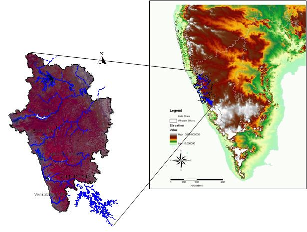
Figure 1. False colour composite image of Uttara Kannada district.
River Kali – It is the northern most rivers in coastal Karnataka, originates at Diggi in Supa Taluk, Uttara Kannada district and traverses for about 184km before joining Arabian Sea at Karwar. For the initial 100 km, the river flows south eastwards and at Thattihalla due to geological fault it flows towards southwest. The river has four major and two minor dams constructed across river Kali. Major dams are at Supa, Bommanalli, Kodasalli and Kadra, while minor ones are at Tattihalla and Kaneri. Pandri, Ujli, Nujji, Thananala, Kaneri and Vaki are the other strems that joins Kali at various places. The entire river basin is about 5,104 sq. km, encompassing dry deciduous-evergreen-mangroove vegetation of the Western Ghats. The Kali river basin receives on an annual rainfall between 850-3200 mm. Figure 2 illustrates drainage network and sampling sites in River Kali.
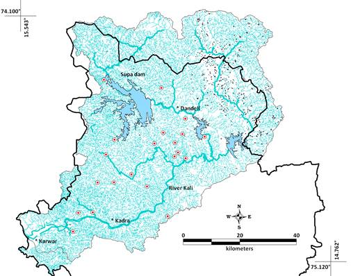
Figure 2. Drainage network and sampling sites in Kali River basin.
River Bedti – River Bedti (also called Gangavalli) originates at Dharwad District as Shalmala and confluences at Kalghatgi with another stream from Hubli, flows westward for about 161km to merge with Arabian sea. It has a catchment of about 3878sq.km, the second largest catchment in Uttara Kannada district. There are two tributaries to this river Shalmala and Sonda. The river forms a fall at Magod from about 220m. The river has dense evergreen, semi-evergreen to deciduous forests along its path. Soils are mainly lateritic. Annual rainfall ranges from 1,700 - 6,000 mm. Figure 3 depicts sampling sites and drainage network in River Bedti.
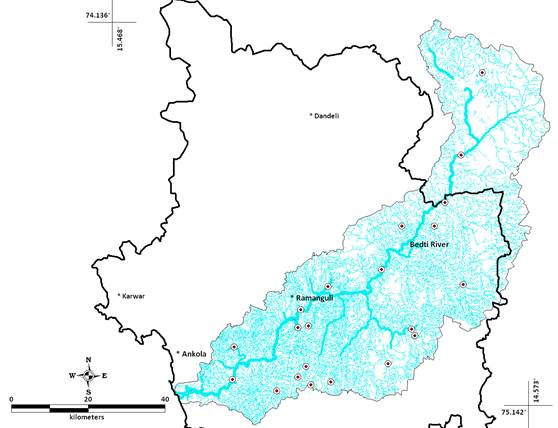
Figure 3. Drainage network and sampling sites in Bedti River basin.
River Aghanashini - River Aghanashini having a catchment of about 1390.52 sq.km traverses westward for about 121km from the origin at Manjguni of Sirsi Taluk, and confluences with Arabian Sea at Tadri. Estuarine part of Aghanashini is 13km long making it as the longest among Uttara Kannada rivers. Unchalli falls (Lashington falls) forms a major water fall of this river. Figure 4 shows drainage map and sampling sites in River Aghanashini. Despite being a small river basin, Aghanashini has diverse vegetation predominates with evergreen-semi-evergreen to mangrove.
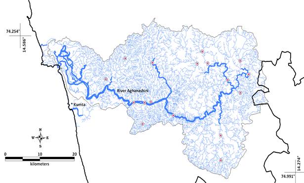
Figure 4. Drainage network and sampling sites in Aghanashini River basin.
River Sharavathi – It originates near Ambuthirtha of Shimoga district, traverses for about 132km and confluences at Honnavar to the Arabian sea. The magnificent waterfall, Jog, is situated in the course of this river. The catchment area of this river is about 3005 sq.km. Only down stream part of the river is within Uttara Kannada district. This river has four dams across its catchment. The first dam was built way back in 1940 at Hirebhaskar, which got submerged after the construction of Linganmakki Dam in 1964. It was among the largest in Asia at that time submerging an area of 326sq.km. Figure 5 illustrates catchment area and sampling sites in Sharavathi River.
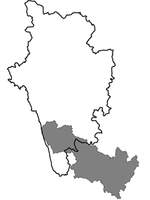
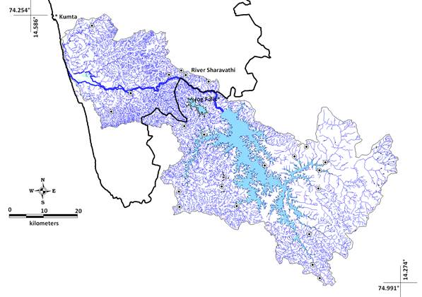
Figure 5. Drainage network and sampling sites in Sharavathi River basin.
River Venkatapura – Smallest of the rivers in Uttara Kannada, Venkatapura has very small catchment area of about 326.2sq.km. The vegetation is predominantly low land evergreen forests. Figure 6 illustrates the sampling sites and catchment of River Venkatapura.
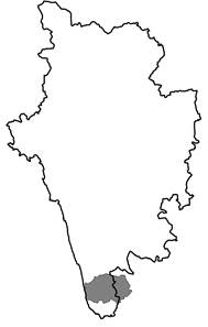
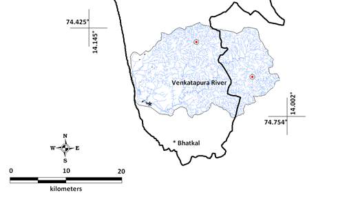
Figure 6. Drainage network and sampling sites in Venkatapura River basin.
Site Selection: Based on the land use and the extent of catchment area in each river basin, 83 sampling sites were selected: two from Venkatapura, 22 from Sharavathi, 15 from Aghanashini, 22 each from Bedti and Kali river basins.
Habitat Variables: Altitude (meters above sea level), rainfall (annual, mm), stream perenniality (seasonal or perennial) and predominating land-use (from the LULC analysis) are used to determine anuran distribution. These habitat variables were graded from lowest to highest. For the analysis, these grades are used than the actual values. River basin wise sampling sites and habitat variables are given in Table 1.
Table 1. Sampling sites and respective habitat variables.
# |
River |
Place |
Altitude (m) |
Rainfall(mm) |
Landuse |
Stream |
1 |
Venkatapura |
Ondalasu |
94 |
4429 |
1 |
1 |
2 |
Venkatapura |
Kelanur |
231 |
4662 |
4 |
2 |
3 |
Sharavathi |
Malemane |
309 |
4171 |
4 |
2 |
4 |
Sharavathi |
Kathalekan |
599 |
4079 |
4 |
2 |
5 |
Sharavathi |
Watehalla |
698 |
4119 |
4 |
2 |
6 |
Sharavathi |
Mavingundi |
611 |
3859 |
4 |
2 |
7 |
Sharavathi |
Dabbe |
609 |
4302 |
4 |
2 |
8 |
Sharavathi |
Hosagadde |
41 |
4240 |
1 |
1 |
9 |
Sharavathi |
Magod |
8 |
4145 |
1 |
1 |
10 |
Sharavathi |
Chandavar |
22 |
3693 |
3 |
2 |
11 |
Sharavathi |
Nandihole |
561 |
2198 |
1 |
1 |
12 |
Sharavathi |
Haridravathi |
563 |
2339 |
1 |
1 |
13 |
Sharavathi |
Mavinhole |
593 |
2583 |
3 |
2 |
14 |
Sharavathi |
Sharavathi |
610 |
3655 |
4 |
2 |
15 |
Sharavathi |
Hilkunji |
601 |
4402 |
3 |
2 |
16 |
Sharavathi |
Nagodi |
572 |
4040 |
4 |
2 |
17 |
Sharavathi |
Hurli |
605 |
3999 |
3 |
2 |
18 |
Sharavathi |
Karni |
657 |
4877 |
4 |
2 |
19 |
Sharavathi |
Yennehole |
578 |
4744 |
4 |
2 |
20 |
Sharavathi |
Muppane |
575 |
4069 |
3 |
2 |
21 |
Sharavathi |
Mundigesara |
657 |
2284 |
3 |
2 |
22 |
Sharavathi |
Niluvase |
763 |
4124 |
4 |
2 |
23 |
Sharavathi |
Sampekai |
578 |
2516 |
1 |
1 |
24 |
Sharavathi |
Hubse |
586 |
2959 |
1 |
1 |
25 |
Aghanashini |
Kathagal |
45 |
3662 |
3 |
2 |
26 |
Aghanashini |
Ullur |
69 |
3793 |
1 |
1 |
27 |
Aghanashini |
Sapurti |
512 |
3196 |
3 |
2 |
28 |
Aghanashini |
Baillalli |
534 |
3769 |
4 |
2 |
29 |
Aghanashini |
Yanahole |
72 |
3553 |
2 |
1 |
30 |
Aghanashini |
Bennehole |
418 |
3769 |
3 |
2 |
31 |
Aghanashini |
Revankatta |
520 |
3300 |
1 |
1 |
32 |
Aghanashini |
Bolurhole |
495 |
3054 |
3 |
2 |
33 |
Aghanashini |
Bilgihole |
489 |
3655 |
1 |
1 |
34 |
Aghanashini |
Hulidevaragadde |
55 |
3694 |
1 |
1 |
35 |
Aghanashini |
Donnehole |
26 |
3641 |
3 |
2 |
36 |
Aghanashini |
Nellimadke |
526 |
2757 |
1 |
1 |
37 |
Aghanashini |
Neralamane |
504 |
3019 |
1 |
1 |
38 |
Aghanashini |
Deevalli |
30 |
3676 |
3 |
2 |
39 |
Aghanashini |
Mudagi |
31 |
3617 |
3 |
1 |
40 |
Bedti |
Abageri |
405 |
3582 |
4 |
2 |
41 |
Bedti |
Andhalli |
491 |
2642 |
2 |
1 |
42 |
Bedti |
Angadibailu |
84 |
3481 |
3 |
2 |
43 |
Bedti |
Chitageri |
524 |
1574 |
2 |
1 |
44 |
Bedti |
Daanandi |
492 |
2245 |
2 |
1 |
45 |
Bedti |
Dabguli |
89 |
2742 |
4 |
2 |
46 |
Bedti |
Devnalli |
541 |
3322 |
1 |
1 |
47 |
Bedti |
Gundabala |
8 |
3478 |
1 |
1 |
48 |
Bedti |
Gunjavathi |
505 |
1747 |
2 |
1 |
49 |
Bedti |
Hasehalla |
71 |
3044 |
3 |
2 |
50 |
Bedti |
Hemmadi |
485 |
2278 |
2 |
1 |
51 |
Bedti |
Kalghatgi |
517 |
1153 |
1 |
1 |
52 |
Bedti |
Kalleshwara |
104 |
3131 |
4 |
2 |
53 |
Bedti |
Karadrolli |
490 |
2025 |
2 |
1 |
54 |
Bedti |
Kelginkeri |
344 |
3481 |
1 |
1 |
55 |
Bedti |
Makkigadde |
52 |
3427 |
3 |
2 |
56 |
Bedti |
Manchikeri |
424 |
2506 |
2 |
1 |
57 |
Bedti |
Melinkeri |
428 |
3496 |
4 |
2 |
58 |
Bedti |
Nyctisite |
531 |
3496 |
4 |
2 |
59 |
Bedti |
Tarihal |
647 |
849 |
1 |
1 |
60 |
Bedti |
Vajagadde |
563 |
3518 |
4 |
2 |
61 |
Bedti |
Yerebail |
497 |
1555 |
2 |
1 |
62 |
Kali |
Goira |
63 |
3074 |
1 |
1 |
63 |
Kali |
Badapoli |
532 |
3407 |
2 |
1 |
64 |
Kali |
Anshi |
529 |
3332 |
3 |
2 |
65 |
Kali |
Jhalavali |
546 |
3191 |
2 |
1 |
66 |
Kali |
Kaneri |
489 |
3149 |
2 |
2 |
67 |
Kali |
Cyntheri |
445 |
2812 |
2 |
1 |
68 |
Kali |
Ulvi |
645 |
3093 |
1 |
1 |
69 |
Kali |
Gunda road |
483 |
2635 |
2 |
1 |
70 |
Kali |
Water1 |
579 |
2430 |
2 |
1 |
71 |
Kali |
Amgaon |
557 |
2370 |
1 |
1 |
72 |
Kali |
Water2 |
564 |
2452 |
2 |
1 |
73 |
Kali |
Mines |
661 |
2531 |
2 |
1 |
74 |
Kali |
Nagzhari1 |
180 |
2414 |
2 |
1 |
75 |
Kali |
Nagzhari2 |
391 |
2224 |
2 |
1 |
76 |
Kali |
Kulgi |
502 |
2085 |
2 |
1 |
77 |
Kali |
Virnolii |
457 |
1932 |
2 |
1 |
78 |
Kali |
Sakatihalla |
17 |
3055 |
3 |
1 |
79 |
Kali |
Beegaru |
257 |
3014 |
4 |
2 |
80 |
Kali |
Kanshirda |
473 |
2012 |
2 |
1 |
81 |
Kali |
Deriye |
640 |
3015 |
3 |
2 |
82 |
Kali |
Castlerock |
571 |
2894 |
3 |
2 |
83 |
Kali |
Gowliwada |
534 |
2125 |
2 |
1 |
Landuse – 1: Agriculture, 2: Deciduous, 3: Semi-evergreen, 4: Evergreen; Stream – 1: Seasonall, 2: Perennial |
||||||
Ecological Guilds: Anuran amphibians in this study were classified into ecological guilds (Table 2) on the basis of four variables describing their functional ecology, namely, endemism (referring to their spatial extent of occurrence), threat status (IUCN, 2009), habitat specificity (aquatic to arboreal, considering aquatic to be very primitive) and finally tadpole habitat (direct development being considered most advanced).
Table 2. Ecological guild gradation used in the present study.
Variable |
Range |
Grade |
Endemism |
Non-endemic |
1 |
|
Endemic to Western Ghats-Sri Lanka Hotspot |
2 |
|
Endemic to the Western Ghats |
3 |
Threat status |
Data deficient |
1 |
|
Least concerned |
2 |
|
Near threatened |
3 |
|
Vulnerable |
4 |
|
Endangered |
5 |
Habitat specific |
Aquatic |
1 |
|
Semi-Aquatic |
2 |
|
Terrestrial |
3 |
|
Fussorial |
4 |
|
Arboreal |
5 |
Tadpole |
Aquatic |
1 |
|
Semi-aquatic |
2 |
|
Arboreal/Direct development |
3 |
Sampling of amphibians: Amphibian sampling was carried out very systematically covering all seasons. Visual encounters, calls, tadpoles, foam nests, spawn are used to record the amphibians in the field. Two man hours of searching is made using torch lights between 19:00-20:00 hr, by walking across the streams, forest floors, gleaning leaf litters, prodding bushes, wood logs, rock crevices etc. All the species encountered are identified up to species level using the keys of Bossuyt and Dubois (2001), and Daniels (2005). New species names are based on literature by Biju et al, (2010) and Dinesh et al, (2010). Opportunistic encounters are also recorded to enlist the species of the region.
Statistical Analysis: Using presence data for species, grading in ecological guilds and environmental variables, non-metric multidimensional analysis (NMDS) is carried out. Non-metric multidimensional scaling is based on Bray-Curtis distance matrix. In NMDS, data points are placed in 2 or 3 dimensional coordinates system preserving ranked differences. Absolute distances are not taken into consideration. Spatial interpolation by Krigging technique is used to produce map with continuous spatial estimate of species endemism based on scattered data points.